
2014
Type of resources
Available actions
Topics
Keywords
Contact for the resource
Provided by
Years
Formats
Representation types
Update frequencies
-
Catchment stream monitoring of water chemistry. Mountainous catchment (59% bare rock) on acid-sensitives soils, 580-690 masl
-
Terrestrial ecosystems monitoring site located in boreal coniferous forests
-
Dataset provides soluble reactive phosphorus (SRP) concentrations measured in Lake Santo Parmense during the period 1953-1954. Water samples for SRP analysis were collected only from the surface layer at the point of maximum depth of the lake. No information on the analytical method used is available.
-
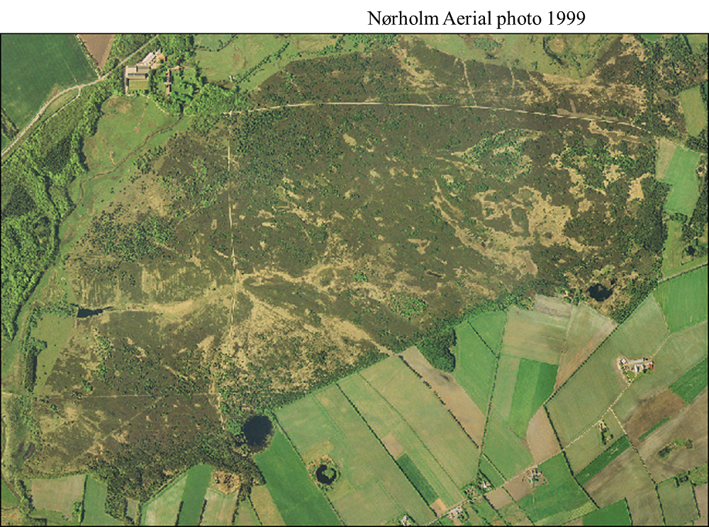
Nørholm Hede (Heath) is situated in the southwestern part of Denmark (8º 37´ E, 55º 41´ N). The 350 ha heath was abandoned and left for free succession since 1895. It was legally protected in 1913 and succession from heather dominated heath over crowberry heath or grass dominated heath towards forest has continued without human interference for about 120 years. Already in 1921, the first survey of tree colonization and development of flora was conducted in permanent grid and plots. Since 1921 a total of 10 surveys have been conducted. The soil is fluvioglacial sand covered by shifting sand in the eastern part. The soil is a sandy podzol but especially in areas with cultivated fields, the profile includes an Ap horizon of 15 to 30 cm and the mor layer is thinner. The western part of the heath was cultivated until 1820 and again in 1870 (Fig 1a). The central and eastern part of the heath is old podsolized dry heathland, which has never been cultivated. Sheep and cattle grazed the heath until about 1895. The fields were probably abandoned several years before. Since 1895 only occasional exploitation of the gravel has occurred.
-
grass dominated catchment located at the south-western coast of Norway, monitored by The Norwegian Agricultural Environmental Monitoring Programme (JOVA)
-
mixed agricultural catchment located in the south-eastern part of Norway, monitored by The Norwegian Agricultural Environmental Monitoring Programme (JOVA)
-
Dataset provides water transparency measured by means of a Secchi disk in Lake Santo Parmense in 1991.
-
Dataset provides phytoplankton densities recorded in Lake Santo Parmense on one date in may 1990. Samples were collected by means of a Ruttner bottle at different depths over the whole water column at the point of maximum depth of the lake. An integrated sample was subsequently obtained by combining equal proportions of samples collected at the various depths and phytoplankton were identified and counted with an inverted microscope according to Utermöhl (1958).
-
Dataset provides phytoplankton densities recorded in Lake Santo Parmense in 1991. Samples were collected by means of a Ruttner bottle at different depths over the whole water column at the point of maximum depth of the lake. Phytoplankton were identified and counted with an inverted microscope according to Utermöhl (1958). Densities on each date are reported as average of the values measured at different depths.
-
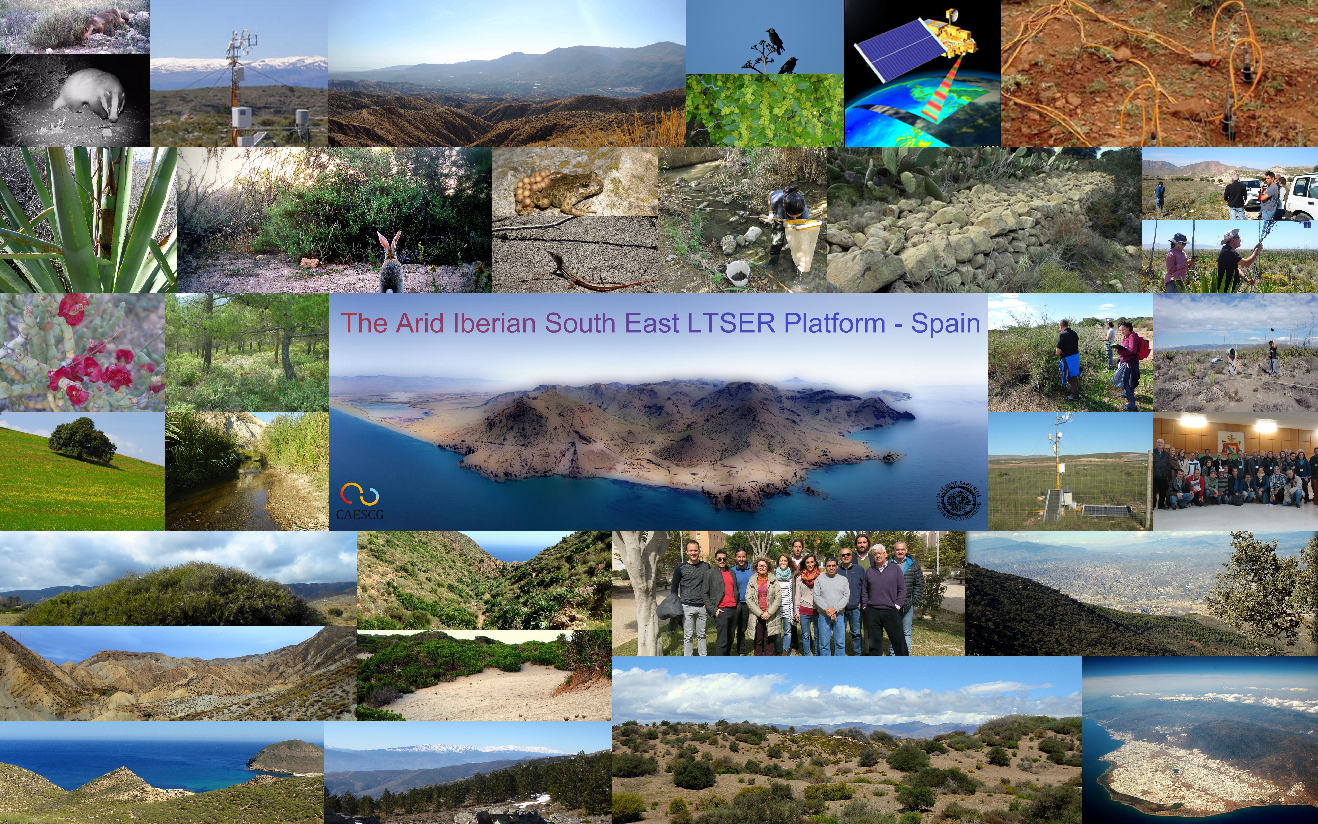
The Arid Iberian South East LTSER Platform aims to seek multidisciplinary solutions to the environmental problems occurring in the socio-ecological systems of Anthropocene. The Platform encompasses a wide range of humanized and semi natural landscapes which make up interesting socio-ecosystems. These singular environments represent both natural processes of aridification as traditional land uses, forcing an effective management of the scarce and irregular water resources. Further, agricultural land abandonment linked to land use changes is driving biodiversity loss and alteration of the ecosystem functioning. All these features provide excellent natural laboratories where researching “in live” similar scenarios as those forecasted in other Mediterranean regions and testing adaptive management models to improve ecosystem resilience. The platform area has an extension of 1,426446 ha including a wide orographic heterogeneity and an altitude gradient from the sea level until 2,260 m. The climate is Mediterranean hot (annual average temperature between 12º-15ºC ) and dry, with some localities where rainfall is lower than 200 mm/year. The traditional uses of natural resources were mining and the exploitation of the species Macrochloa tenacissima as vegetable fibre. Currently, the most frequent land uses are intensive agriculture (e.g., greenhouses), marble quarries, tourism and the service sector derived from these activities. The monitoring program includes several dozens of standardised methodological protocols producing up to date results on ecosystem functioning, biophysical processes, biodiversity trends and social perceptions. Facilities are composed by a laboratory on remote sensing and GIS, a laboratory for biological and chemical analysis, Eddy covariance systems for carbon and water fluxes measurement (atmosphere- ecosystem-soil), a weather station, field instrumental for measuring ecophysiological processes, biological collections, a 4x4 wheel vehicle. The research areas covered by the Arid Iberian South East LTSER Platform are regional ecology by using remote sensing, carbon/water exchange ecosystem-atmosphere/soil-atmosphere and water balance, phenology of xerophytic vegetation, occurrence of invasive alien species, climate trends, land use changes, biophysical and socio-cultural assessment of ecosystem services, spatial distribution of species (birds, mammals and plants), ecological integrity of arid riparian environments, karst systems, and water quality. We are working to guarantee the quality of our datasets and searching for collaborators with the aim of expanding our current dataset catalogue.