
above ground net primary production
Type of resources
Available actions
Topics
Keywords
Contact for the resource
Provided by
Years
Formats
Representation types
-

The National Park covers ca. 70 000 hectares and was founded in 1971. It is located at a climatic transition zone (the climate is Temperate/Atlantic Sub-Mediterranean), with 1-2 dry months in summer. Annual rainfall is usually above 2000 mm, reaching 3500 mm in summits. Granite is by far the dominant bedrock type. The main ecosystem/land cover types are deciduous oak forests, heathland and scrub, meadows and rock outcrops (in highlands), and forest plantations, scrub, urban and agriculture (in lowlands). This site is the only national park in the country, with over 40 years of experience in conservation and management, and since 1997 also part of a transnational park and of a UNESCO Biosphere Reserve (Gerês-Xurés). Also a Natura site (both SCI and SPA). It holds one of the highest diversity of Annex I habitat types in the country. The Park hosts several plant and animal species of high conservation value, including the Iberian wolf (EU priority species) and many other Iberian endemic species of fauna and flora. Also important for several European plant species having their only national occurrence in the National Park. High potential for rewilding in the highest elevations where human activities and only occasional. Available measurements include: updated land cover and Annex I habitat maps (1:10 000 and 1:25 000 scales; for multiple dates); many data available on plant and animal diversity; several PhD projects developed in the Park over the last 15 years; reasonable coverage of climatic stations; geological maps and soil maps available at various scales; low and medium resolution satellite imagery available, and a few HR and VHR satellite images available from previous projects. Main drivers of change (and potential threats) in highlands are farmland and pastoral abandonment, infrastructures (wind farms), changes in wildfire regimes. In lowlands, the key drivers/threats are intensive forestry, expansion of non-native invasive plants, urban development, tourism and infrastructures. Climate change may become an important driver throughout the Park due to its elevation range and climatic transitional situation.
-
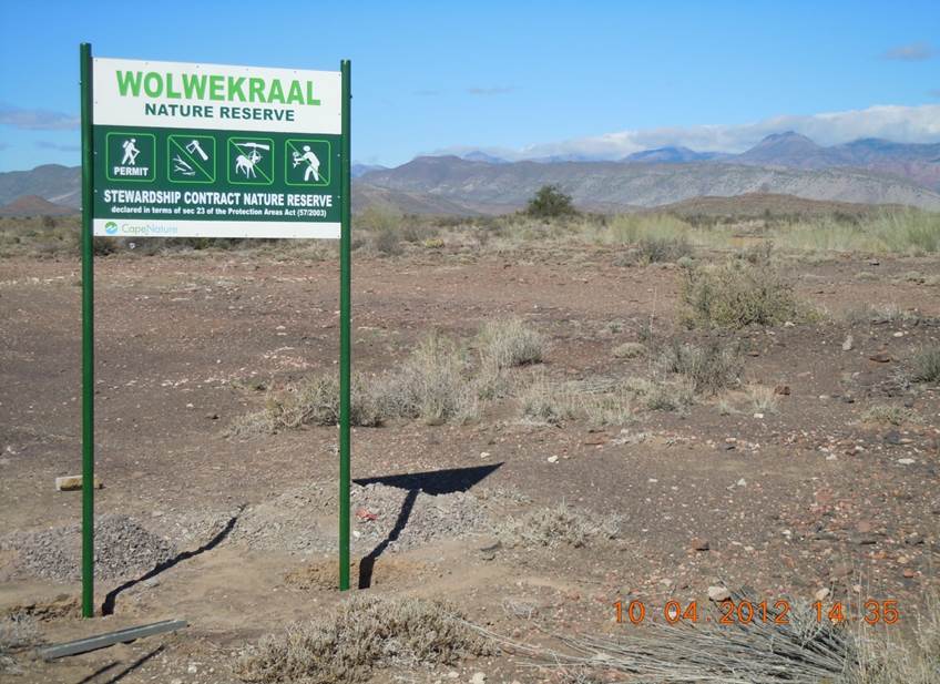
The field site comprises 123 ha of natural Karoo shrubland. The Dorpsrivier passes through the nature reserve. Habitats include exposed Ecca mudstone plains, a north-facing ridge, pockets of aolian sand, and quatzite pebble bed conglomerate along the levees of the Dorpsrivier. The field site has been fenced to exclude domestic livestock since the 1970s.
-
None
-
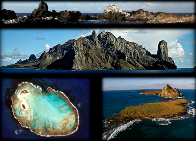
Islands are unique place to be characterized as a long-term monitoring site, sustaining communities and preserved high rate of endemism. For not having the typical impacts of increasing urbanization in the coastal zone, it becomes possible to reliably identify the appropriate sources of impacts (such as overfishing), and the direct consequences on the system. This statement is difficult to precisely on the coast where the synergism disorders does not isolate each process. Still being the islands of control ICMBio with some protection status (Fernando de Noronha = National Park; Atol das Rocas = Biological Reserve), or with ongoing research programs with the logistical support of the Navy of Brazil and funding CNPQ (Archipelago St. Peter and St. Paul and Trindade island), management and conservation rules can be more efficiently deployed without generating conflicts with the various groups of users of the areas, which is a common situation when it comes to coastal systems where 50% of the population live.
-
evergreen broad-leaved forest The mature and old-growth forests dominated by Distylium racemosum, Quercus acuta, Q. salicina, Percea thunbergii and other species. In total, more than 50 tree species are found in the 4-ha plot.
-
Boreal forest consisting of Betula and Acer species.
-
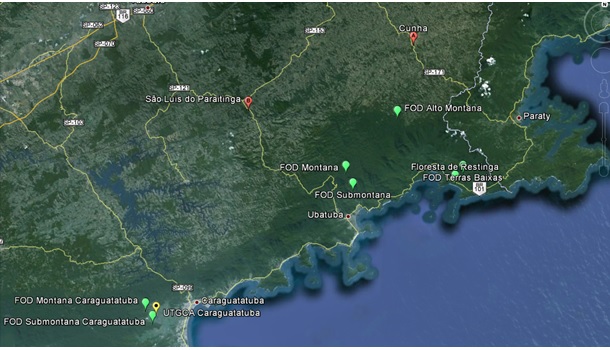
This research site develops long-term ecological studies in experimental units located in Protected Areas along the altitudinal gradient of Atlantic Forest types: Low Altitude Ombrophilous Dense Forest (5 to 50 m above sea level), Submontana Ombrophilous Dense Forest (50 to 500 m above sea level), and Montane Ombrophilous Dense Forest (500 to 1.200 m above sea level). In each altitude, all trees with a DBH ≥ 5,0 cm that fall inside 4 independent 1 hectare permanent plots, divided into a grid of 10 x 10 meter parcels, are being considered. The site extends from 23°15' S a 23° 40 S to 44° 40’ a 45° 40’ W. within areas of the Nucleus Caraguatatuba, Cunha, Picinguaba and Santa Virginia from the Serra do Mar State Park/PESM. The database on composition and structure of the forest will allow a choice of species for more detailed studies on reproduction biology; seed anatomy and reserves; germination; photosynthesis and water use efficiency; nitrogen assimilation, transport and metabolism; plant populations structure and dynamics; techniques; genetic structure of plant populations using molecular markers; determination of forest age by DBH classes and using 14C; determination of annual average growth rates of key species; and phenology. Multivariate analyses has been used to check for functional groups, or groups of species that share a common behavior and ecology. The comparison of different groups along the altitudinal gradient will allow investigation of the effect of altitude in the functioning of these groups. Simultaneously, the inputs of nitrogen through precipitation, biological fixation, and soil mineralization and nitrification are being determined, along with key parameters of N losses through denitrification and export by streams, allowing a preliminary nitrogen mass balance along the altitudinal gradient. Water and carbon balance of the forest will be estimated along with the seasonal variation of this balance through use of micrometeorological towers and Eddy-covariance technique. The photosynthesis/respiration balance of the ecosystem will be used to determine the role of the forest as a sink or source of carbon to the atmosphere. Our final goal is to integrate the results of all activities listed above, scaling-up from individual trees, to families, to functional groups, and finally to phytophysiognomies, allowing us to investigate in detail the structure and the functioning of the forest.
-
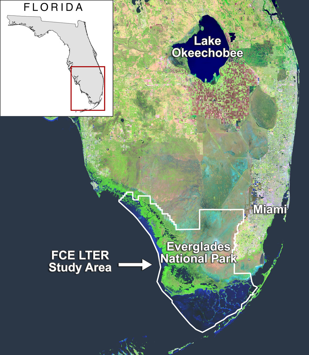
The majority of Florida Coastal Everglades LTER sites are located in freshwater marsh, estuarine mangroves, seagrass estuary ecosystems in Everglades National Park. Everglades National Park covers approximately 4300 km² of south Florida and is part of the greater Everglades ecosystem which extends north to Lake Okeechobee and the Kissimmee River.
-
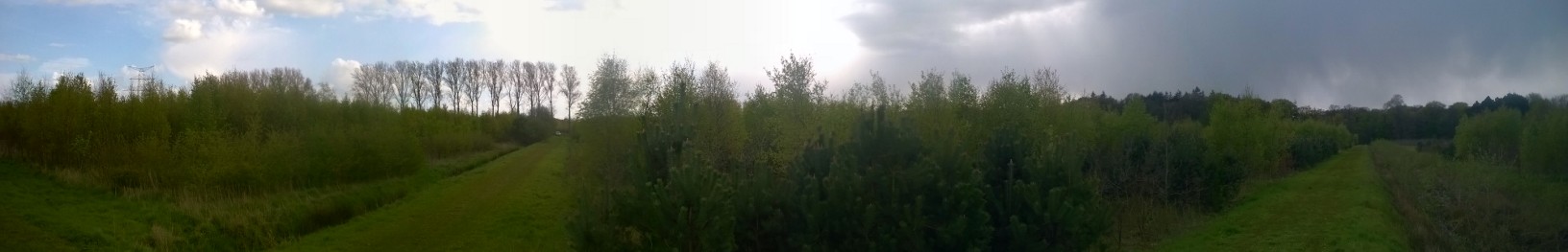
FORBIO is an innovative, large-scale forest biodiversity experiment established in Belgium between 2009 and 2012. The acronym stands for assessment of the effects of tree species diversity on FORest BIOdiversity and ecosystem functioning. At three sites with contrasting site conditions, plots were planted with one up to four tree species. Various aspects of ecosystem functioning will be compared between plots that differ in tree species richness but have developed under the same abiotic conditions. The sites are located in Gedinne (Gribelle, Gouverneurs), Hechtel-Eksel and Zedelgem.
-
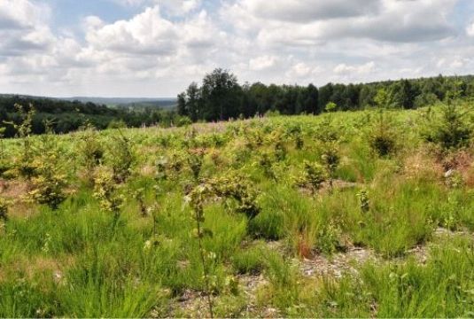
FORBIO is an innovative, large-scale forest biodiversity experiment established in Belgium between 2009 and 2012. The acronym stands for assessment of the effects of tree species diversity on FORest BIOdiversity and ecosystem functioning. At three sites with contrasting site conditions, plots were planted with one up to four tree species. Various aspects of ecosystem functioning will be compared between plots that differ in tree species richness but have developed under the same abiotic conditions. The sites are located in Gedinne (Gribelle, Gouverneurs), Hechtel-Eksel and Zedelgem.