
air water vapour pressure
Type of resources
Available actions
Topics
Keywords
Contact for the resource
Provided by
Years
Formats
Representation types
-
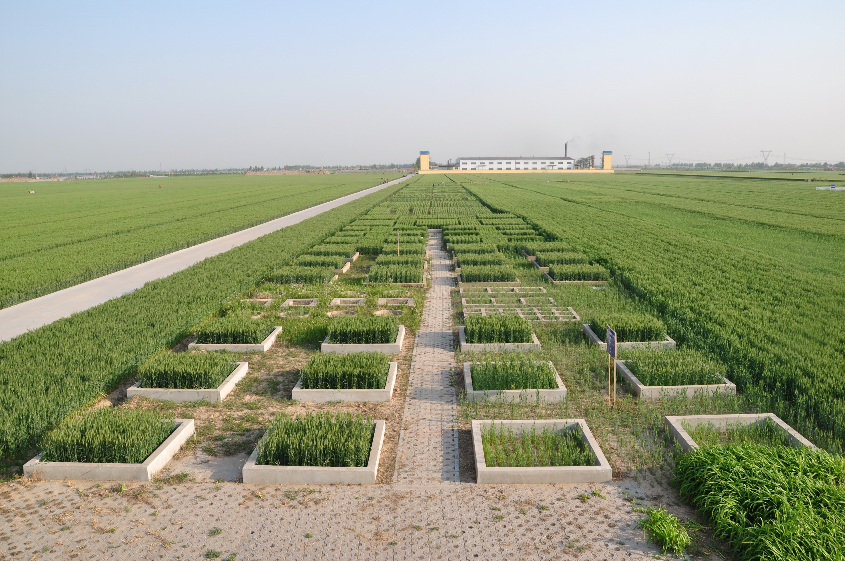
Luancheng station, established in 1981, is one of the field stations of the Chinese Ecosystem Research Network (CERN) and a member of Global Terrestrial Observation System (GTOS). The station is also a demonstration base for modern agricultural technologies in Hebei province. In 2005, the station became one of the stations of the China National Ecosystem Observation and Research Network(CNERN). Luancheng Station is located in Luancheng county of Hebei province (37°53' N, 114°41'E and elevation at 50.1 m), represents the typical high production area in the northern part of the North China Plain. The rapid declining groundwater table has become the main problem that threatens the sustainable agricultural development in this area. The researches conducted at the station focus on the long-term investigations of farmland ecosystem, water and nutrients transfer and regulation mechanisms, modern water-saving technologies, molecular breeding, precision agriculture and regional sustainable agro-ecosystem demonstration models etc.. The station has 28 ha land for field research and provides accommodation for scientists and students to stay. There are laboratories, field research infrastructure and equipments to be used for different experiments.
-
Located in the Cape Horn Biosphere Reserve (UNESCO 2005), the southernmost part of Chile, the Omora Park has a mountain landscape covered by subantarctic forests and wetlands. Omora Park is a botanical garden and protected area, in the north of the Navarino Island, Cape Horn, Region of Magallanes, on the southern shore of the Beagle Channel. This park develops scientific research, education, philosophy, ethics and conservation of the species of the Chilean southern region.
-
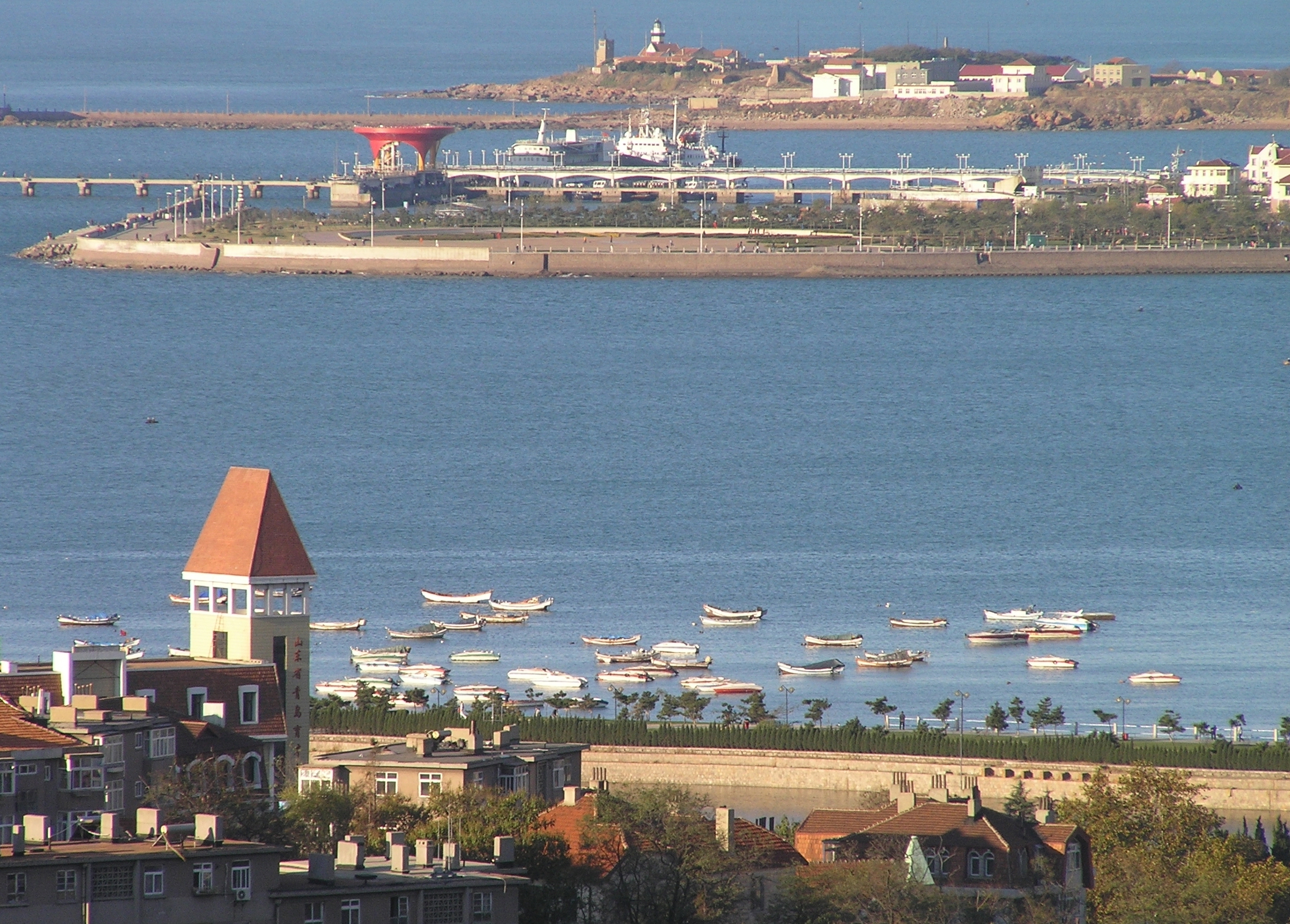
The Jiaozhou Bay, covering an area of 390 km2 between 3538′ and 3618′ N and 12004′ and 12023′ E, surrounded by the Qingdao city. As a semi-enclosed, fan-shaped bay, the narrowest place at the channel connecting with the Yellow Sea, from the Tuan Island to the Xuejia Island, is only 3000 m wide. Its average depth is 6-7 m, with most part of the bayshallower than 5 m, and the tidal zone adds up to 125 km2. The tide of Jiaozhou Bay is regular semidiurnal type. The speed of the flood is greater than that of the ebb, and the duration of the flood is shorter than that of the ebb. There are many peninsulas and islands in the bay, so the circulation inside is complicated. After the residual current analysis, six circulation systems were observed in Jiaozhou Bay. Marine biodiversity and productivity is high in the bay. With the development of Qingao City, the population is increasing quickly around Jiaozhou Bay. Farms, factories, highways, ports, tourism etc. can all affect the environments of the bay. Most of the land-sourced input are from several rivers, such as the Dagu, Haibo, Licun and Nan Jiaolai rivers.
-
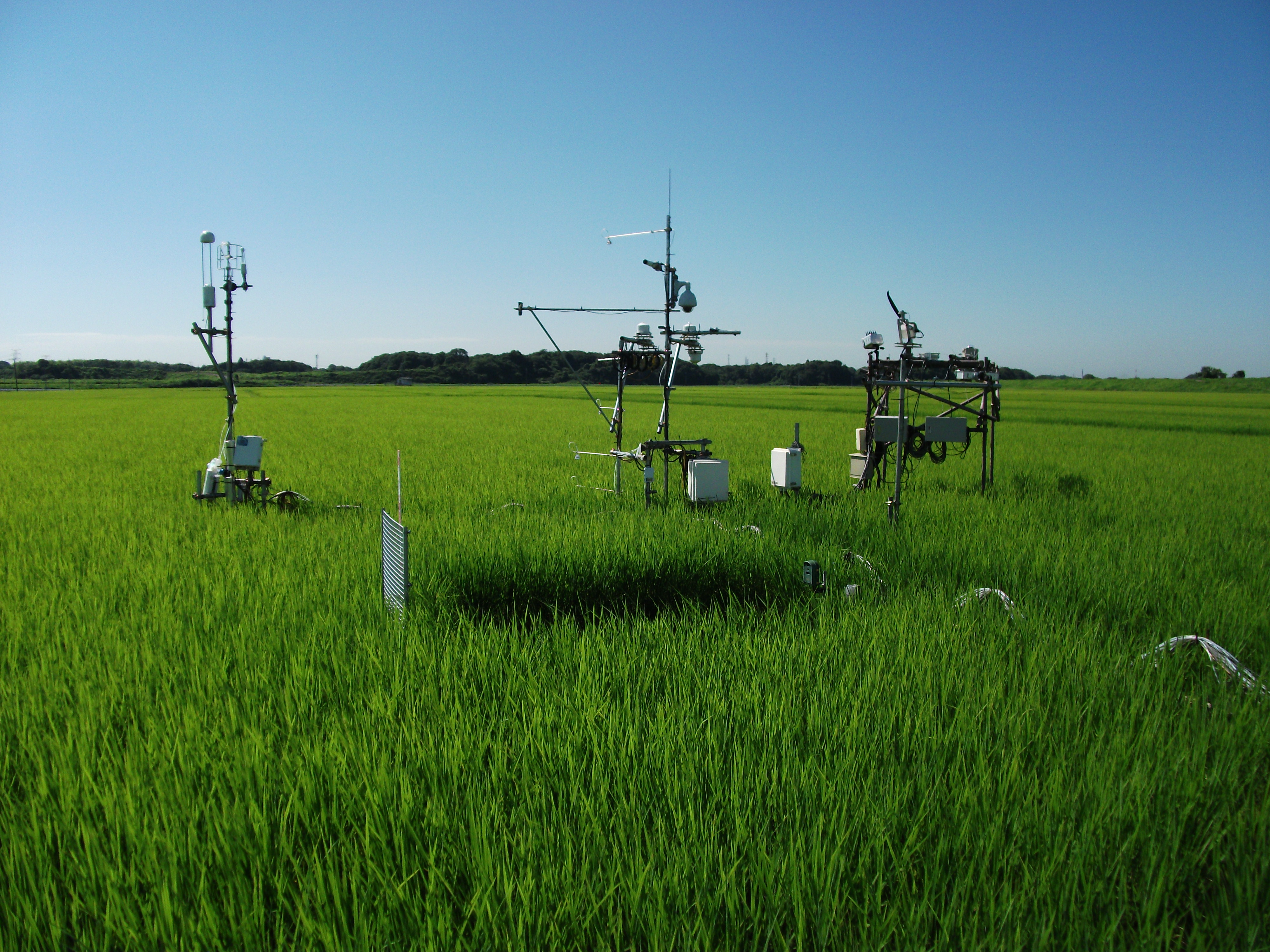
The Mase rice paddy site is a flux station in the AsiaFlux micrometeorological tower network. Located in a regularly cultivated rice paddy area of the Kanto plain in Japan, the site was established in 1999. The initial motivation was to quantify the energy and carbon balance in the rice paddy (ca, 54 a) where the tower was situated. Because of the accessibility and line-power availability, the site has involved many researchers and students from universities and institutes, broadening its target to studies on satellite and field remote sensing, ecosystem modelling, and nutrient cycling.
-
This site experienced peat extraction. It contains Sphagnum plots and Vaccinium oxycoccos, but the peatland is dominated by graminoids forming tussocks.
-
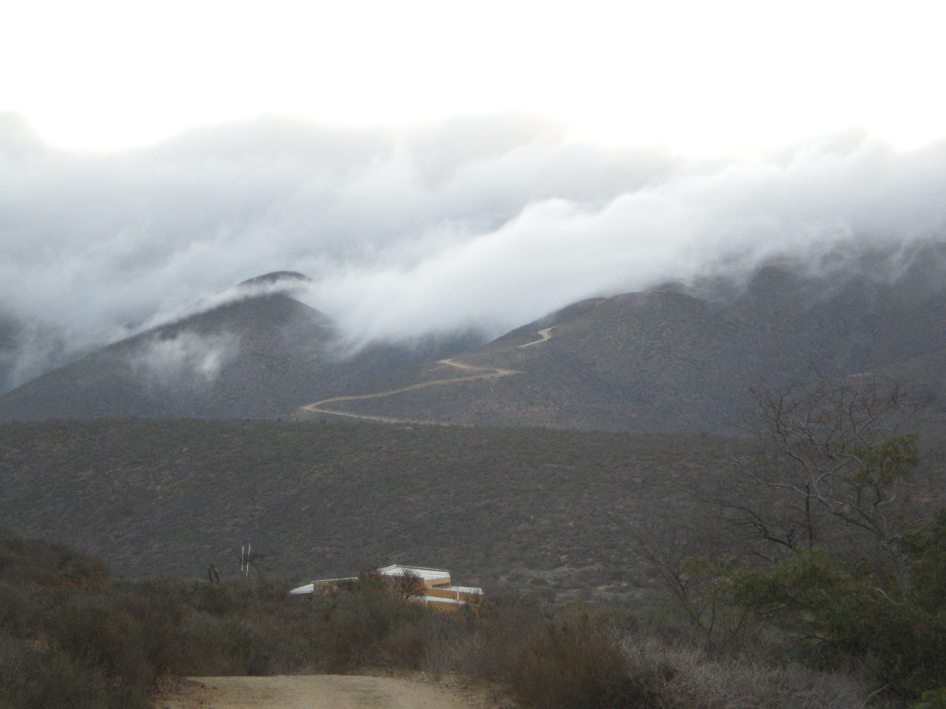
The Fray Jorge experimental site is located inside the Fray Jorge National Park, in the Region of Coquimbo. Its characteristic vegetation is Mediterranean and at the top of the coastal range exists evergreen temperate forests (cloud forests). The climate is Mediterranean with coastal influence.
-
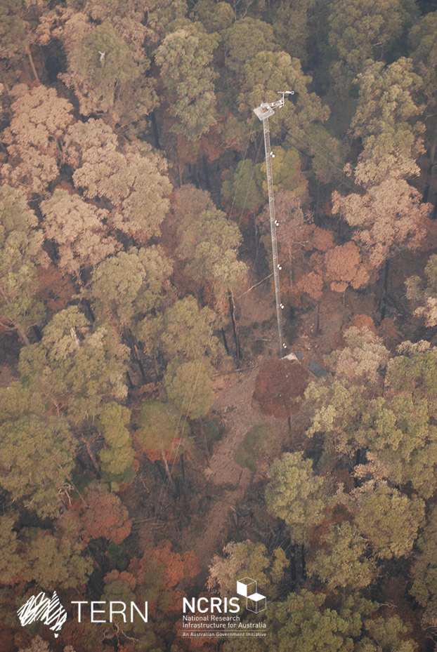
Warra Tall Eucalypt SuperSite is a member of the Australian SuperSite Network (SuperSites, http://www.supersites.net.au/), a facility within the Australian Terrestrial Ecosystem Network (TERN, http://www.tern.org.au/). SuperSites aims to answer both network wide and site-specific science questions through long term monitoring using both sensor technology and classical field methods. The Warra Tall Eucalypt SuperSite is located in southern Tasmania, where tall, wet Eucalyptus obliqua forests predominate, and are part of the cool, temperate wet forest biome. These forests are among the most productive terrestrial ecosystems in the world and their management generates a disproportionately high social and political interest. The site also includes some areas of moorland, temperate rainforest, riparian and montane conifer forest and scrubs. Warra is partly within the Tasmanian Wilderness World Heritage Area, which is managed for conservation, and partly within State forest, which is managed for multiple purposes including wood production. Warra Tall Eucalypt was established as a Long-term Ecological Research (LTER) site in 1995, and is one of Australia’s most scientifically productive. It is a hub for intensive, multi-disciplinary research to understand the fundamental ecological processes in E. obliqua forests and the long-term effects that management has on those processes in contrast with natural disturbance. Current research is focussing on the bio-physical processes that support the biota and how they fluctuate across scales both spatial and temporal. Detailed knowledge exists for many elements of the biota at Warra Tall Eucalypt their habitats, their distribution and their response to disturbance. Importantly, research done at Warra Tall Eucalypt has directly driven improvements in forest management more generally, e.g. the introduction of variable retention silviculture in mature tall, wet eucalypt forests. Key research objectives - What are the fundamental ecological processes in E. obliqua wet forests? - What are the current biodiversity and geodiversity of the site and how are these changing, evolving and interacting? - What are the long-term effects of different forest management and fire regimes on biodiversity, geodiversity and ecological processes? - What are the flows of water, nutrients and energy, the biota through which those flows occur, and how do they assemble, interact, and change over time? - How do disturbances, both natural and human-induced alter the biological, physical and geochemical properties of the ecosystem? In particular, what are the mechanisms through which the ecosystem recovers following disturbance, what are the feedbacks that determine or alter those responses, and what are the thresholds beyond which state changes occur? TERN acknowledges the palawa and pakana people (Tasmanian Aboriginal community) as Traditional Owners of lutruwita (Tasmania).
-
It is located in the region of the Grand Causses, south of the Massif Central. The karstic aquifer of Durzon represents a surface of 100 km² which feeds the spring of Durzon. This spring supplies the drinking water of the Aveyron part of Larzac. The observatory has a set of sites dedicated to gravimetric, inclinometric and hydro-geodesic observations, as well as a flow tower for evapotranspiration measurements.
-
The Sany Bay, covering an area of 120 km2 between 109.3333 and 109.5 E and 18.183 and 18.3 N, surrounded by the Sanya city. It is a typical tropical bay in China. Dongmao Island, Ximao Island and Luhuitou, located in the bay mouth, possess mostly coastal coral reefs. The Sanya River, located in the eastern part of the bay, has many kinds of tropical habitats including coral reefs, mangroves, rocky and sandy shores, mudflats, etc. The coral reefs and mangroves have special resource value and ecological benefits and are, therefore very important to the sustainable social and economical development in these tropical coastal areas. Coral reefs and mangrove areas have important relationships to the regulation and optimization of the tropical marine environments.
-
Curonian lagoon biosphere polygon is a part of ecologic and specialized monitoring system for biological diversity and NATURA2000.