
allele frequency
Type of resources
Available actions
Topics
Keywords
Contact for the resource
Provided by
Years
Formats
Representation types
-
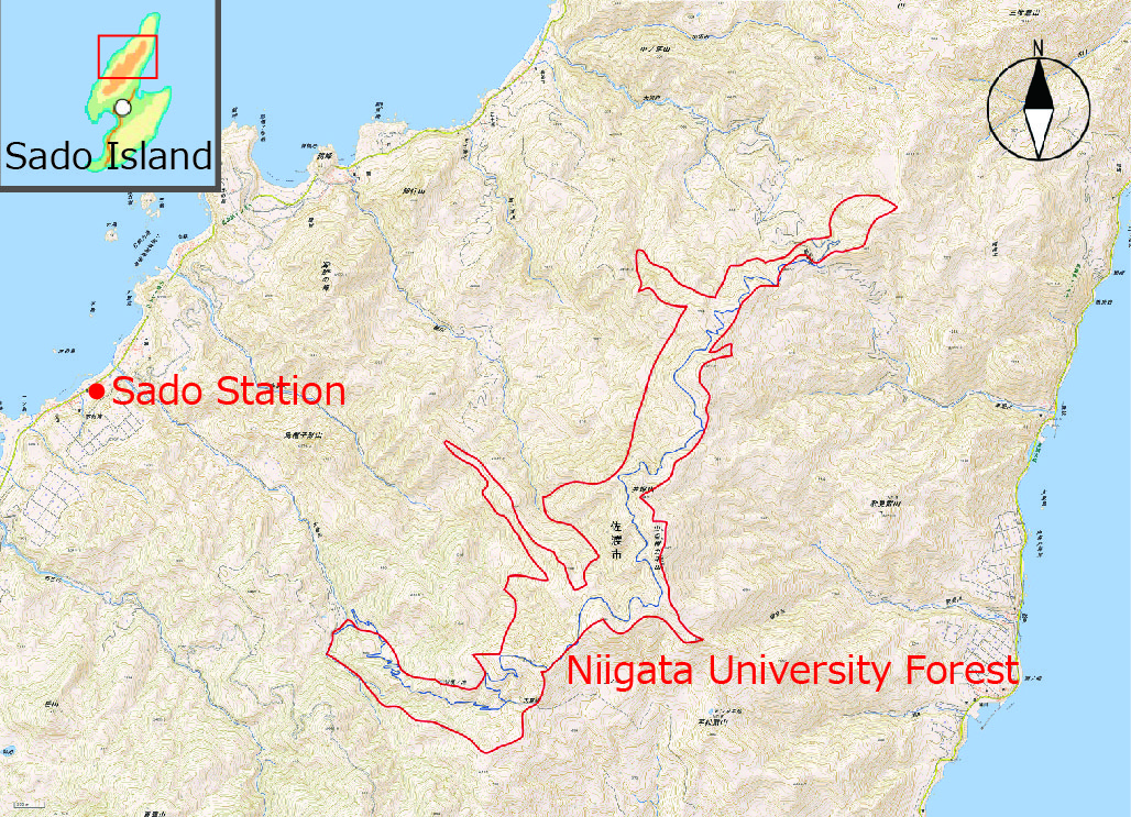
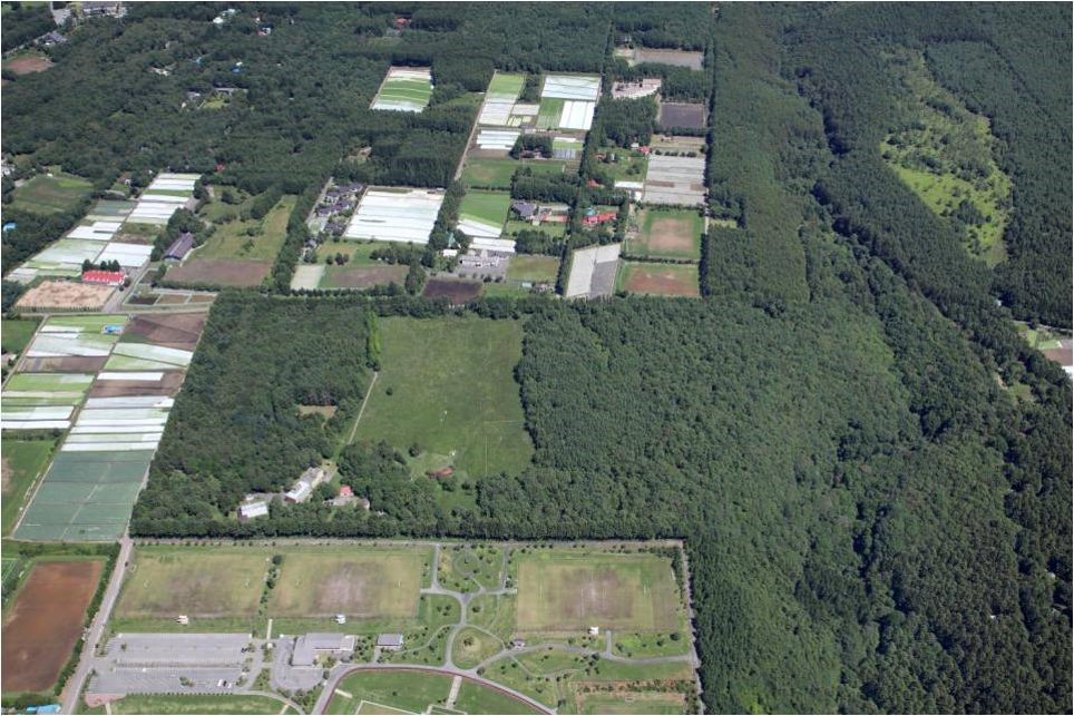
NUF (500ha), which is in the Faculty of Agriculture of Niigata University, is located on Osado Mountains in Sado Island. NUF was found on 1955 and it has been used mainly for education and research of forestry and forest science. NUF has been noted for huge, long-lived conifer timbers (Cryptmeria japonica), two endemic mammals (Lepus brachyurus lyoni and Sorex sadonis), an endemic beetle (Damaster blaptoides capito), and many endangered perennial flowers. Four investigators and Seven technicians are engaged in the station.
-
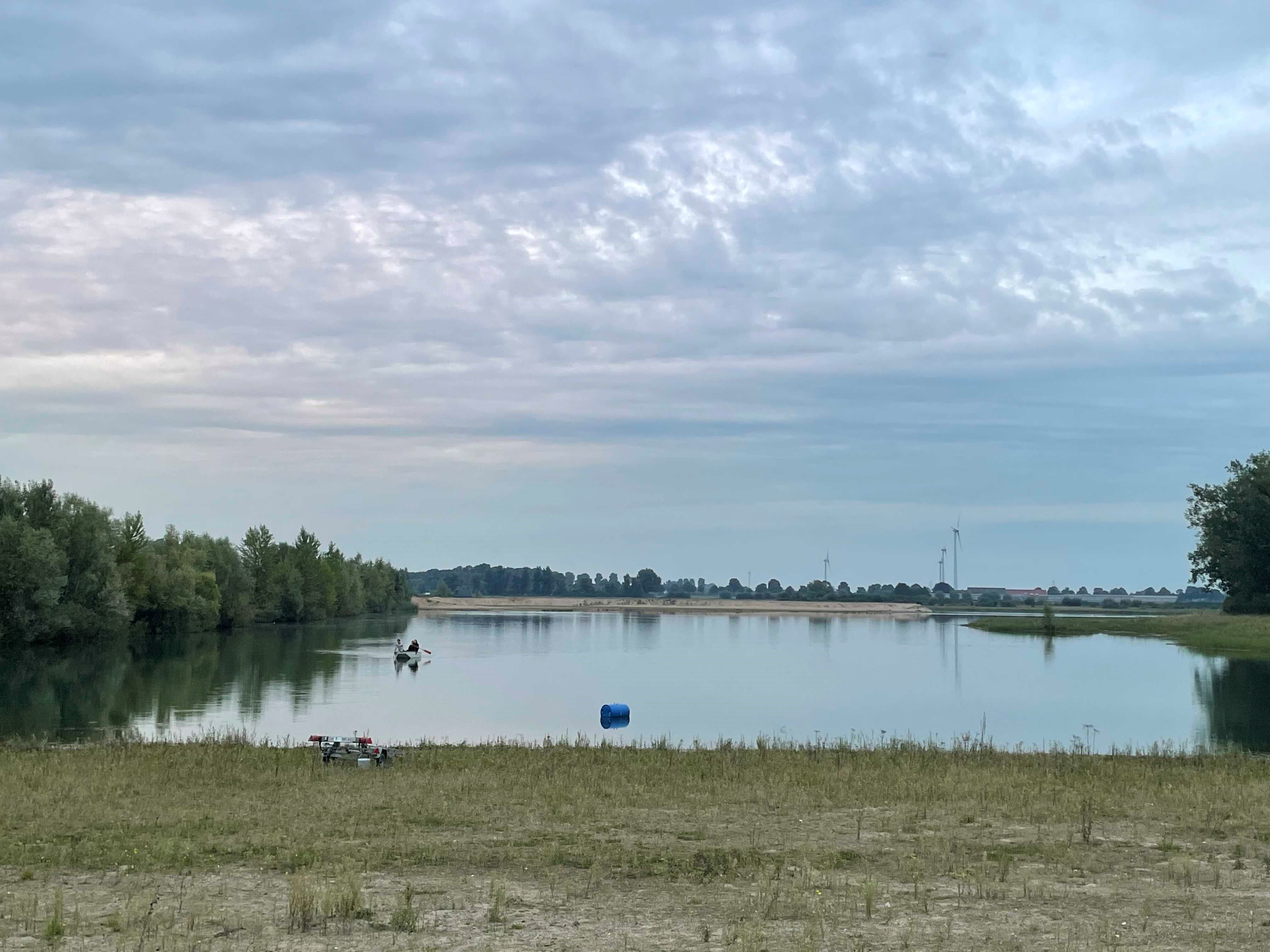
How do freshwater ecosystems react to changing environmental conditions and to what extent can these changes be captured in the dynamics of eco-evolutionary processes? The project REES ('Rhine Eco-Evolutionary System') aims at the long-term assessment of eco-evolutionary interactions in the Rhine as a limnic habitat under consideration of diverse associated water bodies. The study area includes the main flow channel of the Rhine (km 845, North Rhine-Westphalia), as well as Rhine oxbows, Rhine water-fed gravel pit lakes in ecological succession and the surrounding floodplain (Rees, district of Kleve). The Ecological Research Station Rees-Grietherbusch of the Institute of Zoology (University of Cologne) and the Nature Conservation Center District Kleve e.V. form the central infrastructure of the study area. In addition, the Ecological Rhine Station of the University under the direction of Prof. Dr. Arndt is also associated to the project, which enables direct sampling and experimental recording of the main Rhine flow channel. The extensive system of standing and flowing freshwater bodies covered in the REES study site allows the investigation of dynamic variations in biodiversity composition at all levels, from species diversity of communities to genomic diversity at the molecular level of individuals and populations. Along a selected trophic cascade, representative species will be long-term observed and analyzed ecologically and especially also (population-)genomically. The incorporation of ecological genomics is the core aspect of this LTER-D project, which is intended to capture the feedback of evolutionary changes on the ecological system. Population genomic approaches can be used to infer both evolutionary and ecological processes from genomic data. To cope with the dimension of this project, REES is designed as an interdisciplinary collaboration project and currently counts seven project partners with corresponding subordinate projects.
-
A small watershed that collects floods and run-off. The lowest place is home to a (relativity) dense Acacia savana. The slopes are completely bare. The wadi is covered with alluvium resting on a 6 m layer of red surface of late Pleistocene, which includes silt, clay and fine sand. Rainfall is 30 mm
-
The LTSER Zone Atelier Alpes is a research platform that embraces all the French Alps as defined by the European Alpine Convention. The platform hosts several sites dedicated to the long term monitoring of social-ecological systems : one GLORIA site (FR-AME), a large set of permanent plots located along several elevational transects (ORCHAMP project), a network of sentinel alpine pastures, etc. Infrastructures regroups all facilities and observatories maintained by the academic community Univ. Grenoble Alpes. More intensive research investigations concern three master sites: (1) the 'Lautaret-Galibier' master site includes the Lautaret Garden, an alpine field station member of the Anaee network (2) the 'Arves-Mont Blanc' master site ranges from urbanized valleys to the highest summit of Europe (3) the 'alpine trench Grenoble-Chambéry-Annecy' master site is a large area encompassing the urbanized valleys of the western border of the French Alps (Grenoble-Chambéry-Annecy) and nearby mountain ranges (Vercors, Chartreuse, Belledonne & Bauges). The LTSER Zone Atelier Alpes belongs to LTER-France network and is located in south eastern France.
-
The LTSER Zone Atelier Plaine & Val de Sèvre belongs to LTER-France network and is located in the Poitou-Charentes Region, Western France (46°11’N, 0°28’W, 43m average altitude). The main interests of this zone lie in its large size and the historical data related to monitoring of land use by the CNRS-CEBC over the past 26 years (1994 onwards). The site is bordered by the town of Niort to the north, and Chizé forest massif to the south. Approximately 28,000 inhabitants live in the area, in c. 40 villages. The study area size is 45,000 ha, of calcareous plains which are subjected to a warm-temperate oceanic climate. With a mean annual precipitation of 840 mm and regular summer dryness, mixed oak forests would be the potentially natural vegetation. Rain is scarce in summer. Woodlands are mostly reduced to small and scattered remnant patches (mean patch size = 1.87 ha) and hedgerows are widespread in some areas especially in the cattle breeding sectors. Woods are composed of medium-sized trees, maple, ash, cherry or oak (Acer, Fraxinus, Prunus cerasus or Quercus), with a strong presence of elm (Ulmus). Some of the main human derived landscape features of this area are a suburban zone in the North including many garden areas, a motorway on a North-South axis carrying heavy road traffic, and an electricity substation creating a concentration of high voltage power lines in some areas. The ZAPVS aims to elaborate an alternative agricultural system to the productivist model, for ensuring the sustainable management of natural resources.
-
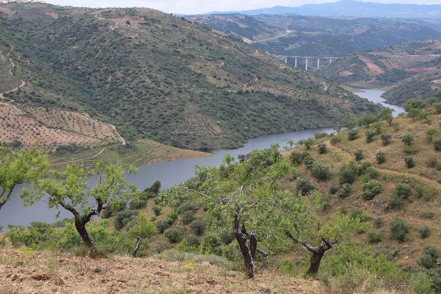
The LTSER Sabor Platform is located in north-eastern Portugal, in the region of Trás-os-Montes, within the watershed of the Sabor river (3868 km2), which drains into the Douro river. It encompasses the lower reaches of the Sabor River and the catchment of its tributaries (1590 km2), part of which were flooded in 2015 by the reservoir of the Baixo Sabor Hydroelectric Infrastructure. Research at this sites focuses on improving our understanding on the long term consequences of river damming on freshwater and adjacent terrestrial ecosystems, and how these effects interact with other socio-economic and environmental drivers operating at scales from local (e.g., land use changes) to global (climate change, biological invasions). Elevation in LTsER-Sabor ranges between 100m (mouth of the Sabor River) and 1100m (Hills of Bornes and Nogueira). Climate is predominantly Mediterranean with continental influence. Annual rainfall ranges between about 500mm and 1000mm, and mean annual temperature ranges between about 10ºC and 16ºC. Considering the thermicity index, It, the site is mostly included in the Meso-mediterranean and Supra-mediterranean zones. Land cover is dominated (>80%)by Mediterranean oak forests and shrublands, pine plantations, olive groves and other permanent crops, and arable cropland and pastures. In terms of Phytoogeograpy, the site was classified in Lusitanean Duriensean sector and in the Terra Quente Superdistrict. The later is characterized by its climatophilous mixed forests of cork oak and juniper (Rusco aculeati-Quercetum suberis subassociation juniperetosum oxycedri ), and its subserial communities, mainly dwarf scrubs of Lavandulo-Cytisetum multiflori and broom-dominated communities of Cytiso multiflori-Retametum sphaerocarpa as forest mantle vegetation and also in progressive successional processes, or Cytiso scoparii-Retametum sphaerocarpa in regressive succession. As a first step in the degradation of cork oak woods, shrubby or woody formations of species with lustrous leaves occur (Arbutus unedo accompanied by thermophilous species like Phillyrea angustifolia, Pistacia terebinthus and Viburnum tinus, or in even more degraded stages, Erica arborea). Cork oak is frequently associated with Q. faginea. Oligotrophic therophytic grasslands are frequent, classified as Anthyllido lusitanicae-Tuberarietum guttati. On more acid and exposed soils, communities of Lavandulo sampaioanae-Cistetum populifolii can be identified. In edapho-xerophilous conditions, mainly occupying steep slopes, holm oak dominated forests, classified as Genisto hystricis-Quercetum rotundifoliae juniperetosum oxycedri, substitute the cork oak woods. In subserial stages, again broom dominated communities, in that case pertaining to Cytiso multiflori-Retametum sphaerocarpa occur, which might be substituted by extremely poor communities dominated by Cistus ladanifer. Under basiphilous conditions, dwarf scrubs of Lavandulo sampaioanae-Cistetum albidi may occur. (Holzer 2003) Bordering the margins of permanent watercourses, with marked edapho-hygrophilous conditions, riparian forest of Scrophulario scorodoniae-Alnetum glutinosae are constant, but they are restricted to very narrow strips of gallery forests, due to the topography of the mainly V-shaped river valley, with Clematis campaniflora and Scrophularia scorodonia as notable companion species. Bordering the temporary watercourses, but also the more lotic facies of permanent watercourses with strong currents, willows of Salicion salviifoliae appear. In the floodplain of Sabor river, rupicolous chamaephytic communities of Diantho laricifolii-Petrorhagietum saxifragae are frequent, with notable thermophilous traits, and a peculiar scrub community dominated by Buxus sempervirens and Erica arborea. (Holzer 2003) Most of LTsER-Sabor is included in the Rede Natura 2000, within the Special Protection Area (SPA) of the Rivers Sabor and Maçãs, classified under the European Directive 79/409/EEC, and the Sites of Community Importance (SCI) of the Rivers Sabor and Maçãs and of Morais, classified under the and 92/43/EEC. Classification of the SPA was mostly due to the populations of birds of prey, including several breeding pairs of golden eagle (Aquila chrysaetos), Bonelli’s eagle (Hieraaetus fasciatus), and Egyptian vulture (Neophron percnopterus). Classification as SCI was due to the presence of a large number of habitats and species of conservation concern, including for instance the wolf (Canis lupus) The Platform is mostly included in the municipalities of Torre de Moncorvo, Alfândega da Fé, Macedo de Cavaleiros and Moncorvo. Human population density in these municipalities is low (12 – 22 inhabitants / km2), and it has declined from about 25% to >50% since 1960. Over the past decades there has also been a tendency for the population to concentrate in the main urban centres. Agriculture is an important economic activity, but there is a pervasive trend for agricultural abandonment due to population declines and ageing.
-
Sugadaira Montane Research Center, established in 1934, is located on the mountain region of 1,300 m alt. in Nagano Prefecture, central Honshu-Island, Japan. In the extensive campus of the Center (35 ha), a sere of vegetation succession is well preserved, and seral stages of the secondary succession for the last one hundred years are sequentially and chronologically arranged: a Miscanthus grass field (A) - young pine forest (about 45 year-old) (B) - mature pine forest (about 60 year-old) (C) - older deciduous broad-leaved forest (about 100 year-old) (D).
-
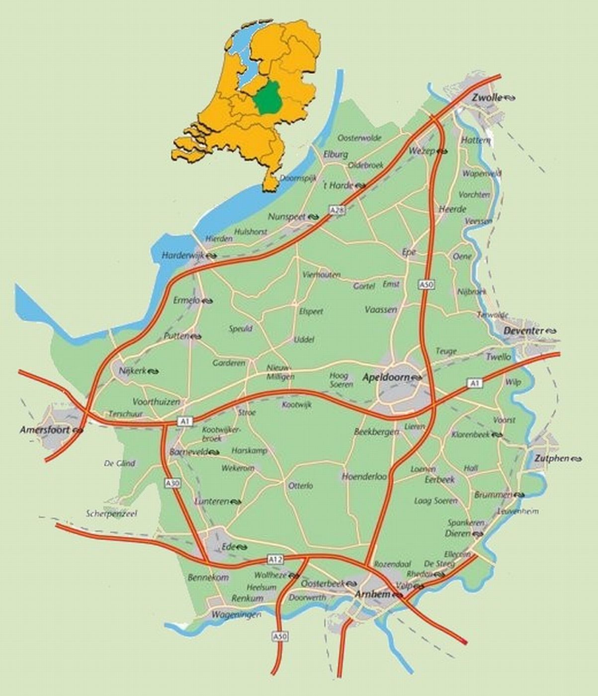
The area defined as ‘the Veluwe’ lies in the province of Gelderland, the Netherlands, West of the river IJssel and North of the river Rhine. The region hosts the largest connected nature area of the country: around 91.947 ha are part of the Natura 2000 area. The natural landscape consists of a mix of forests, heathlands, sand drifts, lakes, and moorlands. The Veluwe was settled a long time ago, and the area is now densely populated (van der Zouwen, 2006). Traces of burial mounds and agricultural fields are indicators of former human settlements. During prehistoric and medieval times, extraction of iron and timber took place on the Veluwe. After the start of the 19th century, large scale deforestation occurred, with several consequences for the nature and the landscape of the area. Human colonization increased rapidly in the 20th century. This resulted in increased infrastructure, intensified agriculture, and increased water extraction, with consequences for the groundwater levels and biodiversity (Jongmans et al., 2012; Schaminée and Jansen, 2009). As it stands, the present nature regions are surrounded by agriculture, settlements, or infrastructure. This means there is a lot of interaction between humans and nature. For example, the National Park De Hoge Veluwe and the Kröller-Müller museum and surrounding attractions get more than half a million visitors per year (ZKA Consultants & Planners, 2013). The unique circumstances of highly populated areas combined with nature provide great opportunities for research on the varied interactions between nature and humans to be carried out. A great array of different ecological and socio-economic research has already been carried out in the Veluwe, which makes it a good quality LTSER platform right from the start. One criteria for a LTSER platform is the definition of relevant themes or research questions (ILTER, 2014).