
atmospheric parameter
Type of resources
Available actions
Topics
Keywords
Contact for the resource
Provided by
Years
Formats
Representation types
-
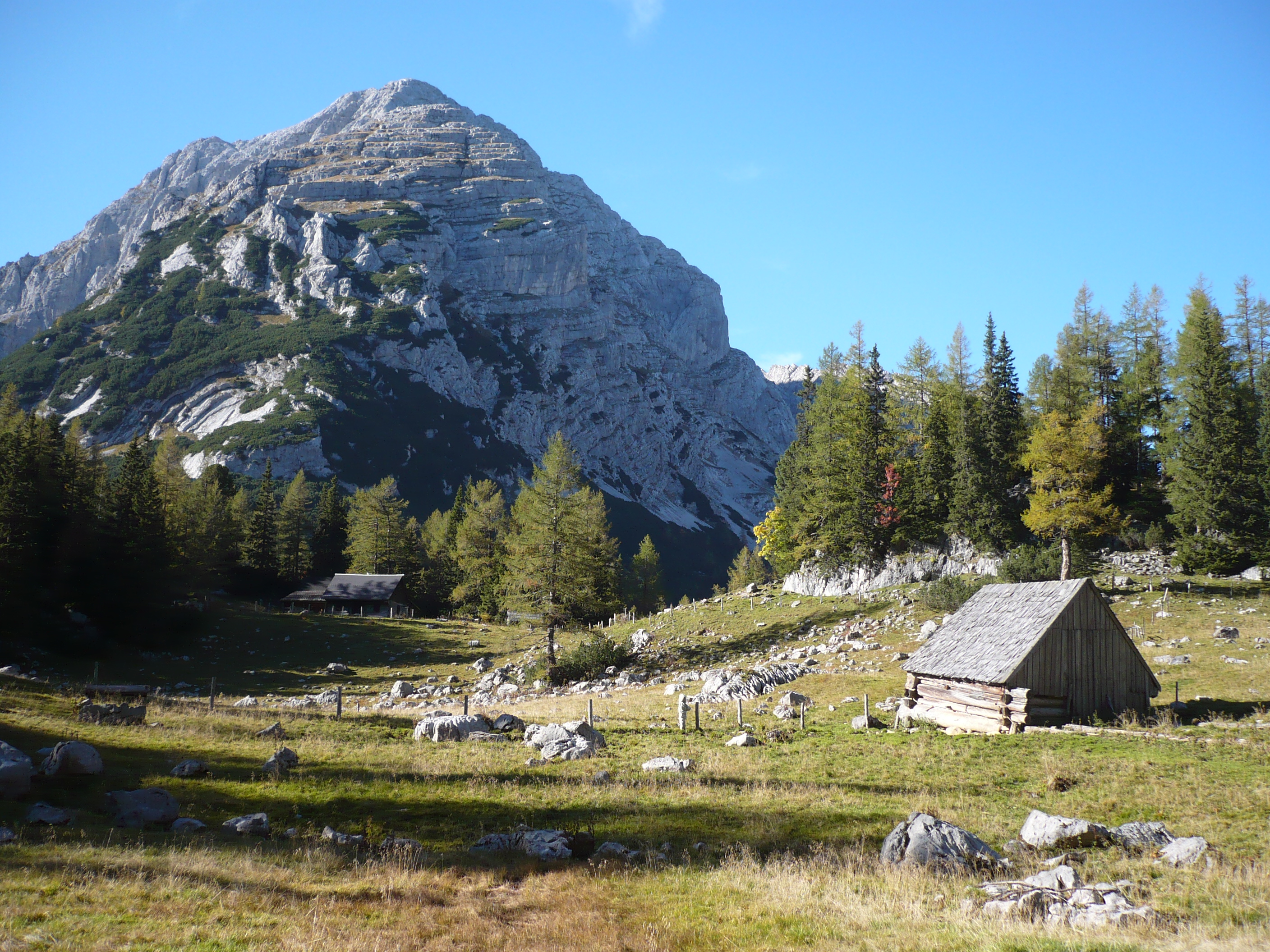
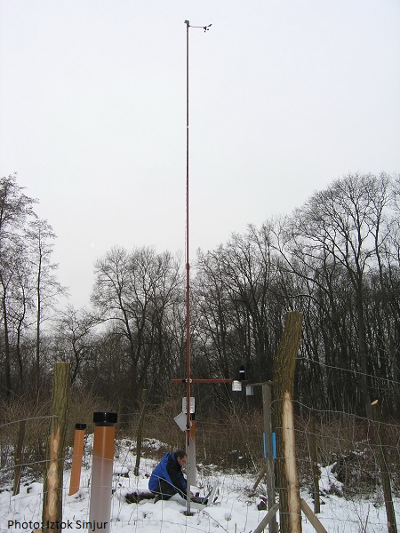
The Johnsbach river basin is situated in the Ennstal Alps (Styria) and covers an area of approximately 65 km2. Elevations range from 600–700 m in the valley to over 2,300 m in the summit regions. Due to its status as a comparatively small, high Alpine river headwatershed, research activities have a strong regional context. The Johnsbach valley is an area of high diversity in a variety of aspects, geological framework, relief energy, morphological and hydrological dynamics, or gradients in meteorological variables. Similarly, the economic interests are also varying: forest management, Alpine pasture farming, water resource economics, tourism (mountaineering, recreation, in winter skiing and dog sledding), and "no use" (national park). The catchment is situated in the administrative area of the community Johnsbach, the northern part belongs to the Gesaeuse National Park. The Johnsbachtal test site is located in a high-lying valley in the northern part of Styria and is surrounded by the Gesaeuse mountains in the North, East and West and by the Western Eisenerzer Alps in the South. The landscape is dominated by high Alpine rock formations, forests and meadows with highest elevations found at the sumit of Hochtor (2369 m). The lower altitudes of 700-900 m are partly covered by settlements. The area has been chosen for the construction of a hydrometeorological station network out of various reasons: The complex topographic, hydrological, geological, geomorphological and meteorological conditions found here pose a scientific challenge for all kinds of environmental monitoring and modelling. The region itself is a classic representative of suistanably tourism regions with, compared to other sites, a moderate number of visitors throughout the year. Covering an area of 65 km2, it is of reasonable size to allow the application of environmental models at high temporal and spatial resolution. Finally, its closeness to the city of Graz and the enormous support of the local communities make this region an ideal site for the establishment of an environmental monitoring network. The main concerns of current activities are: - hydroclimatological measurements - geomorphology and sediment budgets - long-term monitoring - research cooperations - education and training - sustainable tourism and management - model development, parameterization and validation To achieve these goals, a network of hydroclimatological stations has been installed at the following locations: - Oberkainz (920 m, recorded parameter: temperature, precipitation, wind speed and direction, humidity, global rad., shortwave rad., longwave rad., snow water equivalent) - Zinödl (2191 m, recorded parameter: temperature, wind speed and direction, humidity, global rad., longwave rad.) - Blaseneck (1969 m, recorded parameter: temperature, wind speed and direction, humidity, global rad., longwave rad.) - Schröckalm (1344 m, recorded parameter: temperature, precipitation, wind speed and direction, humidity, global rad., shortwave rad., longwave rad.) - Kölblwiese (870 m, recorded parameter: temperature, wind speed and direction, humidity, global rad., longwave rad.) - Oberkainz (920 m, recorded parameter: temperature, precipitation, wind speed and direction, humidity, global rad., shortwave rad., longwave rad.) - Gseng (633 m, recorded parameter: river discharge) - Etzbach Gauge and Etzbach spring (850 m, river discharge, water temperature, electrical conductivity) A runoff and bedload measurement station is currently (Dec 2013) under construction at the "Bachbrücke" (catchment outlet). Further meteorological data is available from four stations operated by the local national park adminsitration (Nationalpark Gesäuse), the avalanche service (LWD) and the Central Institute for Meteorology and Geodynamics (ZAMG).
-
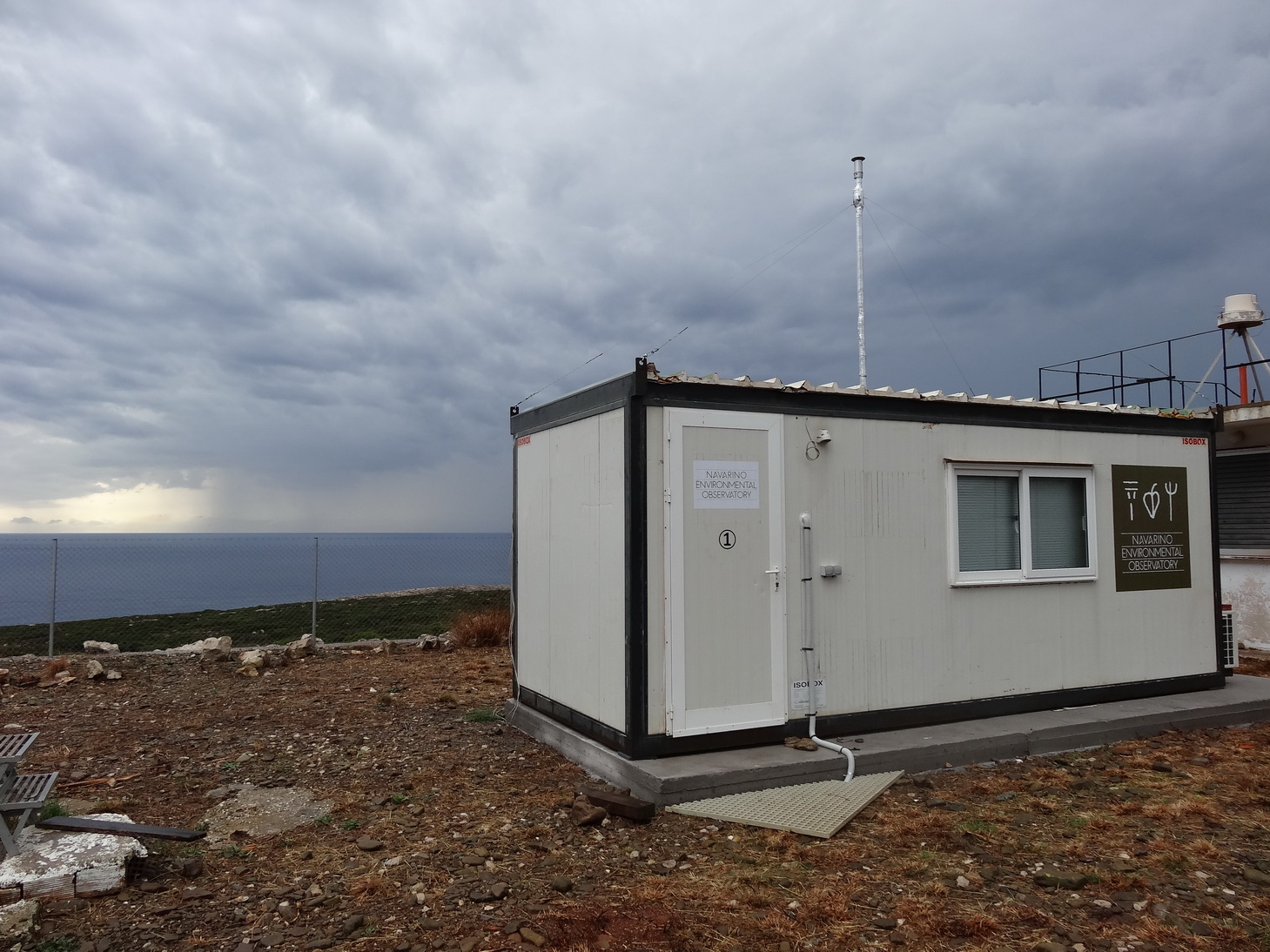
The Navarino Environmental Observatory (NEO) is a pioneer in Greece as an international partnership, between the academic community and the private sector in the field of research and education on climate change and the environment in the Mediterranean region. (www.navarinoneo.gr). NEO started its full operation in 2010 as a collaboration between Stockholm University, the Biomedical Research Foundation of the Academy of Athens (BRFAA) and TEMES S.A.. The unique climate and landscape of the Messinia region makes it an ideal location for research on climate and environmental change. NEO has already become an international hub for frontline research and education, where scientists from all over the world meet to exchange knowledge and ideas.
-
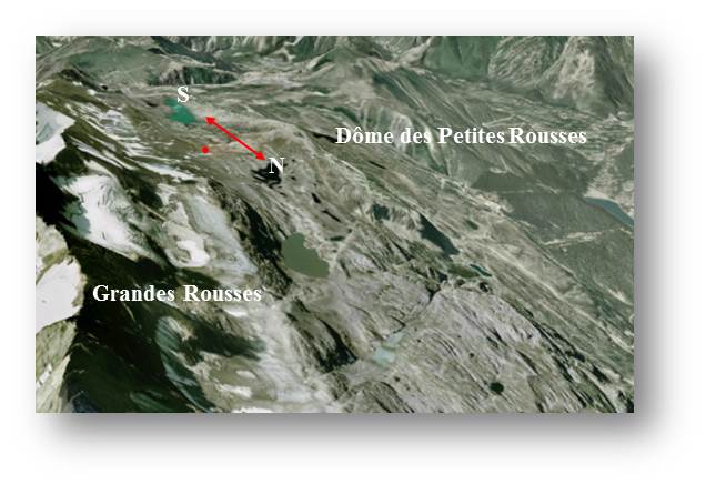
Col du Lac Blanc experimental site is located at the Alpe d'Huez ski resort near Grenoble in the French Alps. Col du Lac Blanc experimental field is located around 2700 m a.s.l and is oriented north–south. The area consists of a large surface of relatively flat terrain (about 25 ha). The pass orientation and the specific configuration of the surrounding summits make the pass closely resemble a natural wind tunnel.The north–south direction accounts for 90% of the wind directions. Aeolian snow transport is observed 10% of the time in winter and occurs with concurrent snowfall 37% of the time It has been dedicated to the study of blowing snow in high mountainous regions for approximately since 1989 by IRSTEA (Snow Avalanche Engineering and Torrent Control Research Unit) and Meteo France (Snow Study Centre).
-
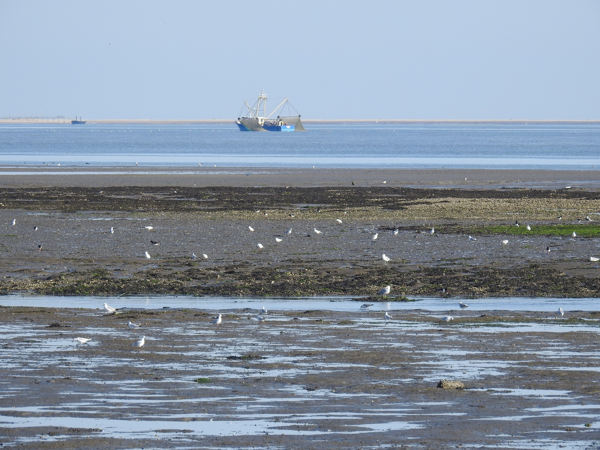
The Dutch Wadden Sea area is a large coastal area (615510 ha) bordering the north of the Netherlands. A range of inhabited barrier islands (included in LTSER Dutch Wadden Sea Area) separate the Dutch Wadden Sea from the North Sea. The barrier islands comprise sandy beaches, dunes, grazed and ungrazed saltmarsh areas, and polders with meadows and villages. The Dutch Wadden Sea itself consists of intertidal mudflats and subtidal areas. The southern border of the area consists of inhabited polders, many of which consist of reclaimed saltmarsh areas. The Dutch Wadden Sea is part of the international Wadden Sea, extending along the coasts of Denmark, Germany and the Netherlands. The international Wadden Sea comprises the largest tidal flats system in the world, where natural processes proceed to a large extent undisturbed.
-
http://meteo.gozdis.si/?page_id=44 (only in SLO language)
-
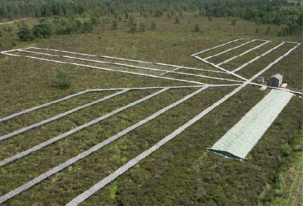
Whim bog offers a globally unique comparison of how the main N forms affect semi-natural vegetation, with meteorological data and treatment history since 2002. A quantified ammonia concentration / deposition gradient, is provided, plus a wet deposition system, comparing oxidized (NaNO3) and reduced N (NH4Cl), where treatments are meteorology dependent. ie. wind direction and rainfall frequency define the treatment exposure(~120 events y-1). Wet plots are large (13m²) and there are 4 replicates per treatment. Opportunities exist to evaluate a whole range of ecosystem services from conservation to carbon sequestration, GHG emissions and water chemistry in addition to understanding how changes in vegetation affect the delivery of these services.
-
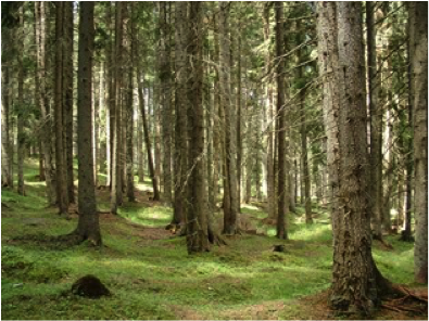
This Site is a macrosite that groups 5 Sites located on the Italian Alps, covered by primary or secondary Picea abies dominated forests, ranging from 800 to 1800 m a.s.l. spread from the Eastern Alps to the Central Alps. 4 of these 5 sites belong to ICP F
-
Hochjochferner (glacier) is located between the Schnalstal and the Venter valley. It extends over an area of 612 ha from the Grawandspitze (3.251 m) and the Fineilspitze (3.514 m) to the Hochjoch (2.750 m) and into the Rofen valley. The western part of the glacier was used as year-round ski area until 2012.
-
Hintereisferner (glacier) is located at the end of Rofen valley between 2500 and 3750 m altitude. The glacier is situated in Naturpark Ötztal, and one of the glaciers with longest records of glacier mass balance worldwide. In addition to that, a number of hydrological and meteorological observations complete the data base. Currently, 3 weather stations and 6 rain gauges provide data. Topographic and land cover data are available, in the recent years on an annual base. The area is used for Alpine tourism (but without a hut in the basin), for limited hunting and growing a few sheeps.
-
The Caribou-Poker Creeks Research Watershed (CPCRW) is a relatively pristine, 104 km2, basin reserved for meteorologic, hydrologic, and ecologic research, with no current human influence (other than scientific research). The CPCRW is the only research watershed in the United States located in the region of discontinuous permafrost, which comprises a large portion of Alaska and most of interior Alaska.