
bare soil cover
Type of resources
Available actions
Topics
Keywords
Contact for the resource
Provided by
Years
Formats
Representation types
-
Studies on ecological successions have a long tradition and strongly contributed to the understanding of community assembly, niche theory and ecosystem structure and functionality. Reports on ecological successions are however mostly restricted to one or two taxonomical groups, neglecting the mutual influences and dependencies between multiple taxonomic groups that are the building blocks of multidiverse communities. We introduce the Alpine research platform Ödenwinkel to promote observational and experimental research on the emergence of multidiversity and ecosystem complexity. We established n = 140 permanent plots along the successional gradient of the forefield of the Ödenwinkelkees glacier at the end of Stubachvalley in the Hohe Tauern range (National Park Hohe Tauern, Land Salzburg, Austria). In summer 2019 we completed a first full inventory of biotic and abiotic characteristics of these plots covering the diversity and composition of vascular plants, bryophytes, arthropods and other animals, bacteria and fungi as well as some geomorphologic properties. In this paper we introduce the design of the research platform and show first results on the diversity and composition of vascular plants along the successional gradient. The Ödenwinkel platform will be available as long-term ecological research site where researchers from various disciplines can contribute to accumulate knowledge on ecological successions and on how interactions between various taxonomical groups structure ecological complexity in this alpine environment.
-
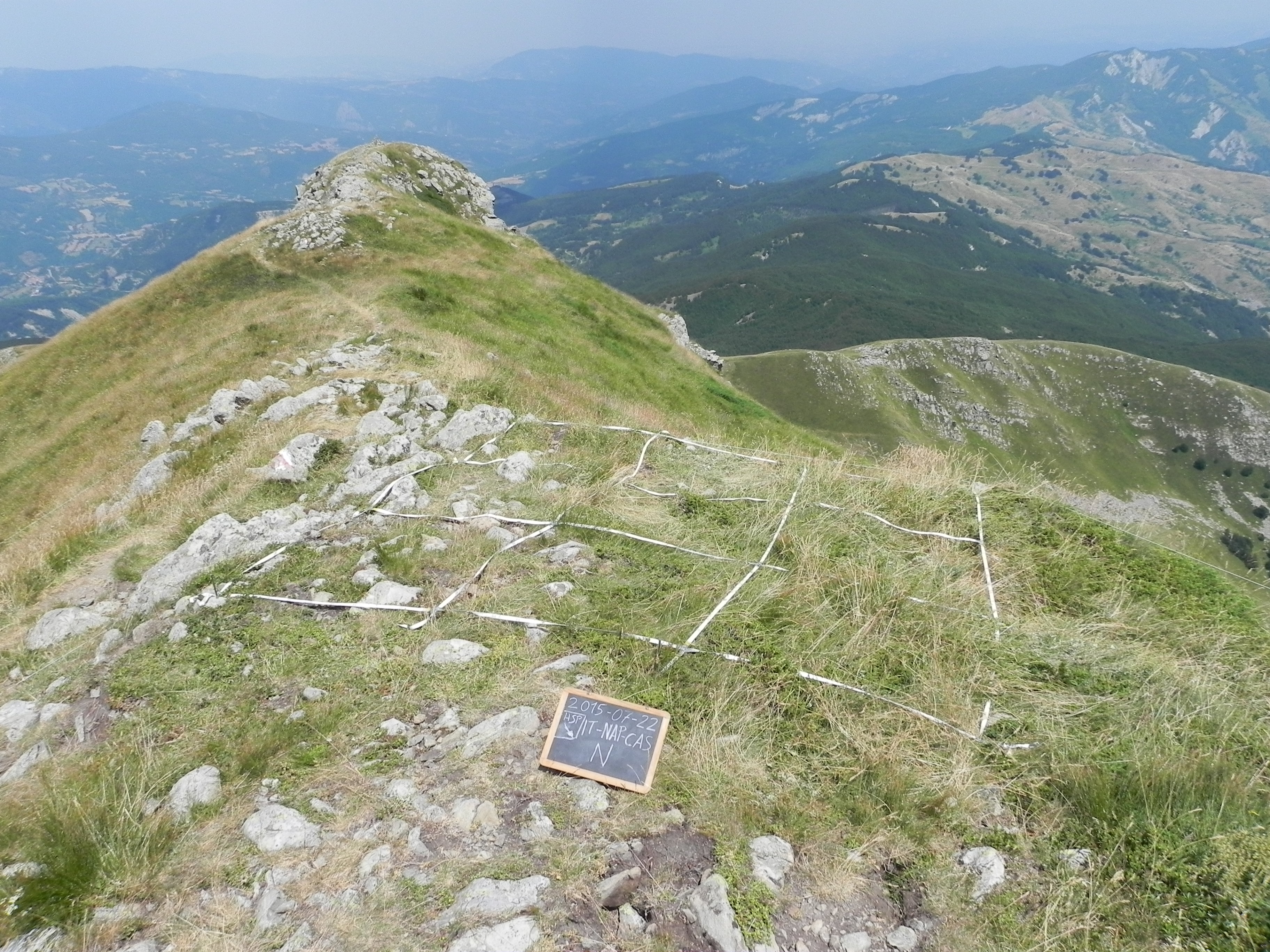
The site consists of “orographic islands” with high elevation vegetation in central Mediterranean basin, along the Apennines mountain range, within the Appennino Tosco-Emiliano National park and partially in the Appennino Modenese Regional park. It includes 64 permanent plots for plant species monitoring, distributed from timberline zone to the subalpine/alpine belt (1722-2000 m), that belong to the GLORIA project’s world network (GLobal Observation Research Initiative in Alpine ecosystems); The plots lie at the top of four summits, displayed along an altitudinal gradient, chosen following the GLORIA Target Region selection criteria. Furthermore, other 26 permanent plots, detached from the GLORIA project, have been settled on mount Prado. The observation and the long-term monitoring of vegetation and alpine plant species population started in 1999. The collection of soil temperature and osmotic potential started in 2001 and 2013, respectively. The site is resurveyed regularly to collect vegetation data (in term of presence/absence and coverage) and climatic data (temperature and osmotic potential data series recorded every 30 minutes by data loggers) in order to assess impacts of climate change on plant communities and single plant species of interest.
-
The site is a revitalized young steppe habitat patch, dominated by fescue (Festuca rupicola). The average altitude is around 100 m. The site is a grazing spot and it was recently used for the reintroduction of the European ground squirrel (Spermophilus citellus) to the area after 70 years. Other important species present at the site include Vojvodina blind mole rat (Nannospalax (leucodon) montanosyrmiensis) and Spring meadow saffron (Bulbocodium versicolor).
-
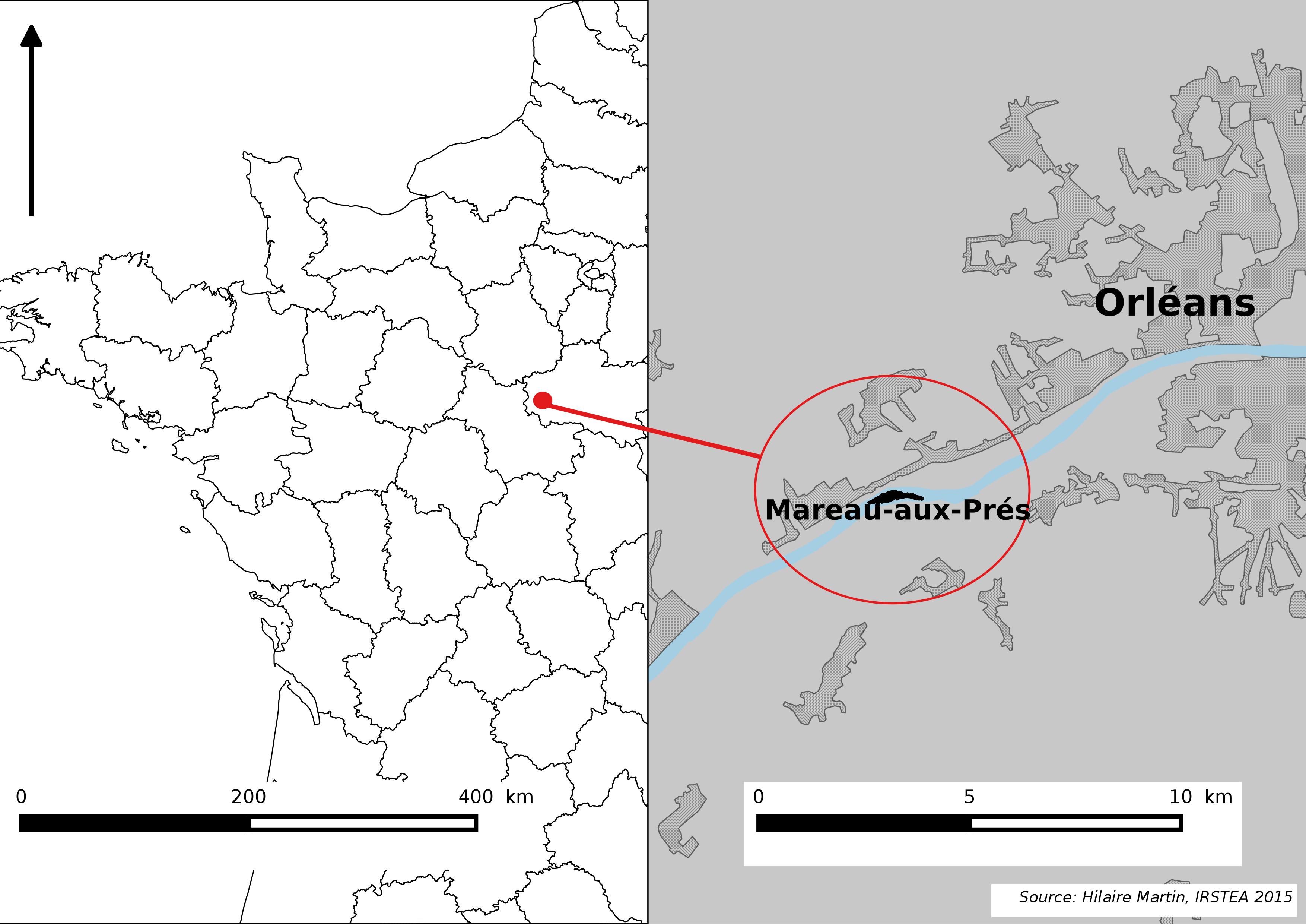
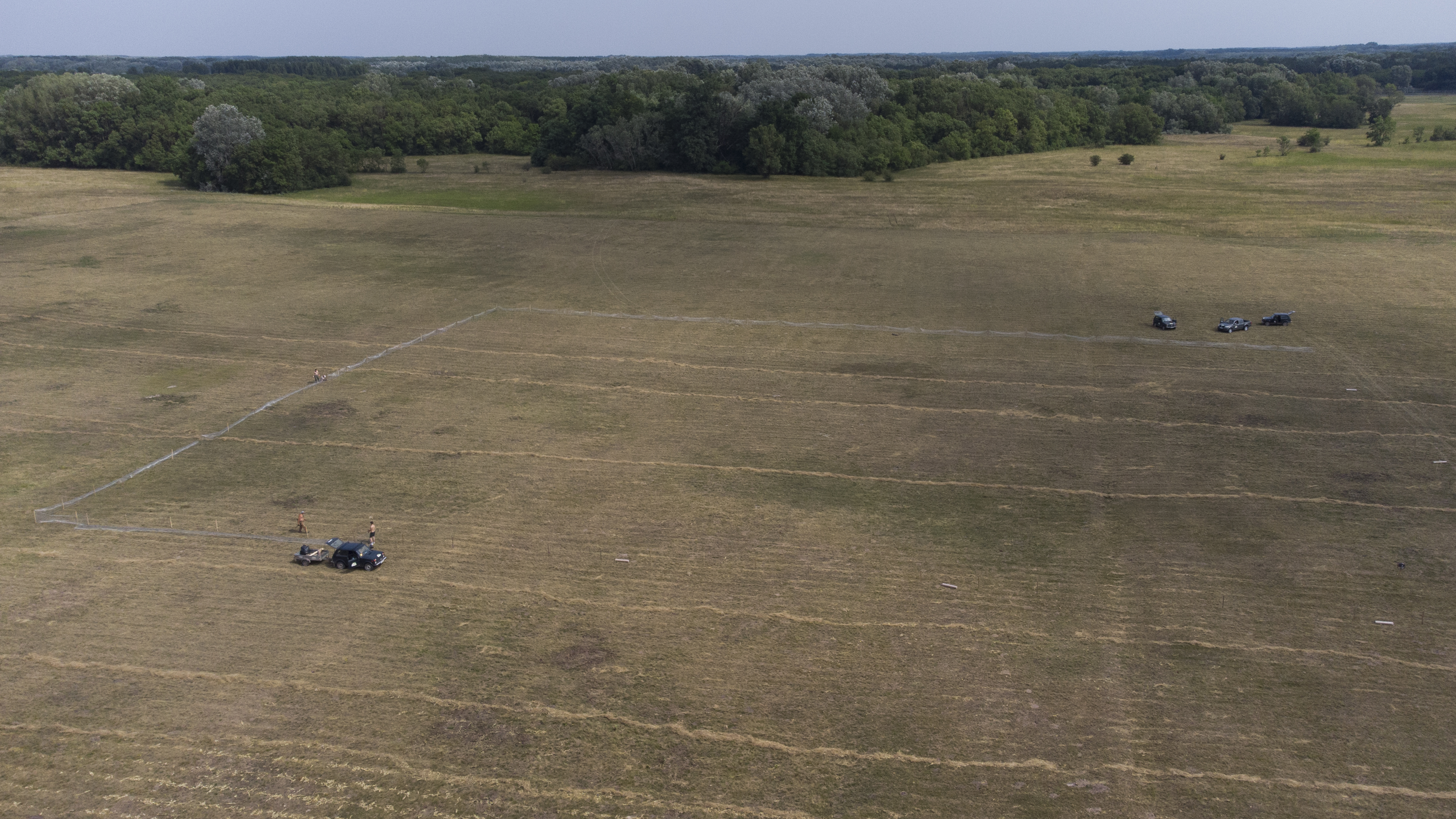
The Mareau-aux-Prés islands, along the Loire river, are characterized by a multiple channel pattern, where natural limestone riffles influence the morphology and spatial distribution of vegetated islands, secondary channels and alluvial bars. Within these islands, in september 2012, fluvial management operations (FMO) were launched. The vegetation of the central sandy-gravelly bar (3 ha area) was uprooted and the bar level lowered in order to maintain the flow capacity of the river. A new sandy-gravelly bar appeared in spring 2013, ideal field support for studying long-term ecological issues. A multidisciplinary research program (‘BioMareau’ project) is currently being conducted from 2012 to 2019, focusing on biodiversity recolonization and on interactions and feedbacks between biotic and abiotic compartments.
-
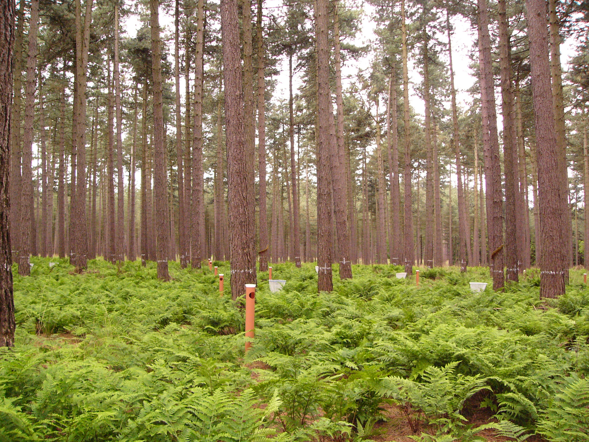
This LTER-site corresponds with a 0.25 ha intensive forest monitoring plot (ICP Forests Level II) including a 0.25 ha buffer zone. The site is located in a homogeneous stand of Corsican pine (Pinus nigra ssp. laricio var. Corsicana Loud.) planted in 1930 on former heathland and is part of Gewestbos Ravels, a landscape (about 1000 ha) with deciduous and coniferous forests, heathland, bogs and pastures in the northern part of the Campine ecoregion of Flanders. The terrain is gently sloping (1-2 %) and the soil is a well-drained sandy soil (Endogleyic Folic Brunic Albic Arenosol (Dystric)). Ground vegetation is dominated by ferns (Dryopteris dilatata and D. carthusiana) and Vaccinium myrtillus. After a storm in February 2007 felled several trees an understorey of Betula pubescens started to develop. Intensive monitoring was started in 1987 with the main objective to study the effects of air pollution on biogeochemical cycling and forest performance (growth, vitality). This yielded a number of long-term data series including on atmospheric deposition, air quality, soil and soil solution chemistry, tree mineral nutrition, ground vegetation and growth. Monitoring will be continued in the future as a statutory task of INBO.
-

Berchtesgaden National Park was established in 1978 and is the only German national park located at the Alps. It comprises three major valleys and covers an elevantional range from 600 to 2700 m. Ecosystems include montane mixed forest and subalpine coniferous forest, alpine grasslands, pastures and rocky habitats. The Department for Research and Monitoring is linked to the Techincal University of Munich. It conducts monitoring on climate, hydrology, ecosystem dynamics and biodiversity. Main research topics include drivers of natural ecosystem dynamics, human impacts on ecosystems and climate change effects on ecosystems.
-
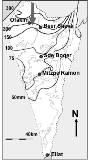
Designation: Ecosystem research and management under land-use and climate change. Climate: Mean annual precipitation 150-200mm between November and April; mean maximum summer temperature 34° C, mean minimum winter temperature 6° C. (Data avialable for 15-min interval meteorological measurements and daily summaries for rainfall, air and soil humidity and temperature, wind velocity and direction, from 1997 to the present.) Principal biomes: Semiarid shrub land (shrub-grass steppe), rocky and loessial watersheds, ephemeral streams. Vegetation is dominated by patch-forming dwarf shrubs (Noaea mucronata, Atractylis serratuloides and Thymelea hirsuta) with species-rich annual winter vegetation in the inter shrub (dominated by Stipa capensis and other grasses) and shrub patch understory (dominated by Anagallis arvensis and other forbs). As a result of drought there are also two new sub biomes: crust land and grass land. Management: Livestock grazing excluded in central watershed (20 ha) since 1987; restricted/controlled grazing by Bedouin sheep herds in surroundings; in the outer parts of the area native and exotic trees were planted in 1985-87 in contour dykes (‘shikhim’) on the slopes and in terraces in the riverbed. Research: 1. Long-term experiments (up to 20 years) for monitoring changes in abundance, diversity, species composition and distribution, and development of biological soil crusts (BSC), perennial plants (dwarf shrubs) and winter annuals in relation to rainfall, soil disturbance, patch distribution, and livestock grazing. 2. long term hydrological studies on rainfall-runoff relationship under natural and manipulation experiments. 3. Short-term experiments and surveys (1 to 5 years) A. for testing hypotheses about the detailed processes, mechanisms and interactions involved in the development, dynamics and stability of shrub- and BSC-dominated patches, their landscape mosaic patterns and their feed-back relationships with flows of materials through the landscape; B. for testing hypothesis on the effect of geodiversity on the stability of shrub land to extreme drought and understanding state changes in drylands. 4. Long term studies on cross scale-cross level interactions in natural and human modified landscape. 5. Network-related research including regional comparisons of herbaceous plant productivity in open rangeland along the Israeli North-South rainfall gradient, and global comparison of woody plant diversity effects on ecosystem functionality of most dryland regions of the world.
-

The Cairngorms National Park is one of 15 National Parks in the UK (one of two in Scotland) and is Britain's largest National Park (4,528 km2). It is the location for some of the most spectacular landscapes in Britain and is home to an incredible diversity of wildlife and plants. http://cairngorms.co.uk/the-park/facts-figures/ The aims of the National Park are: • To conserve and enhance the natural and cultural heritage of the area; • To promote sustainable use of the natural resources of the area; • To promote understanding and enjoyment (including enjoyment in the form of recreation) of the special qualities of the area by the public; • To promote sustainable economic and social development of the area’s communities. Cairngorms National Park, seven broad habitats can be identified: • Enclosed farmlands • Woodlands • Open waters (rivers, lochs, wetlands and floodplains) • Mountains • Moorland • Semi-natural grasslands • Urban • Population of c17,500 • 25.8% of population over 60 (higher than Scottish average) • Average health index in top 25% of Scotland (based on deprivation indices) • Extensive core paths network • 55 Munros including 5 summits over 4000 feet • 3 ski centres • National Cycle Network Route 7 • 1 Long Distance Route (Speyside Way) • Relatively low atmospheric pollution • Annual precipitation over 2250mm on summits and under 900mm in straths • Average annual snow cover 200 days on summits and 50 days on low-ground • Prevailing winds from south-west
-
Mols Bjerge National Park or Nationalpark Mols Bjerge is a Danish national park in the area known as Mols Bjerge (lit.: Mols Hills) in Syddjurs Municipality, Central Jutland, inaugurated on the 29th of August 2009. The protected area, measures 180 square kilometres (69 sq mi) in size. The Mols Hills, reaching a height of 137 metres (449 ft), are centrally located in the park, and take up 2,500 ha. "More than half of all wild Danish plant species" can be found at Mols Bjerge. The park comprise most of the southern parts of the headland of Djursland. It is bounded on the east by the sea of Kattegat, the forests of Kaløskovene in the west and to the south by multiple inlets, coves and plains of glacially generated moraine. The town of Ebeltoft, along with villages and summer house residence areas, are considered part of the park. Land in the national park is held under both private and state ownership. Nearly 33% of the park is cultivated and 80% of the hill area is under private ownership. Mols Bjerge National Park has a rolling and widely varying topography of woodlands and open countryside, created with the end of the last ice age. Elevation in the park area varies in height rising to a maximum of 137 metres (449 ft) in Mols Hills, with many types of habitats such as heath, forests, pastures, bogs, meadows, a variety of coastal habitats and sea
-
Beech forest in the Central italian Apennines