
benthic invertebrates presence
Type of resources
Available actions
Topics
Keywords
Contact for the resource
Provided by
Years
Formats
Representation types
-
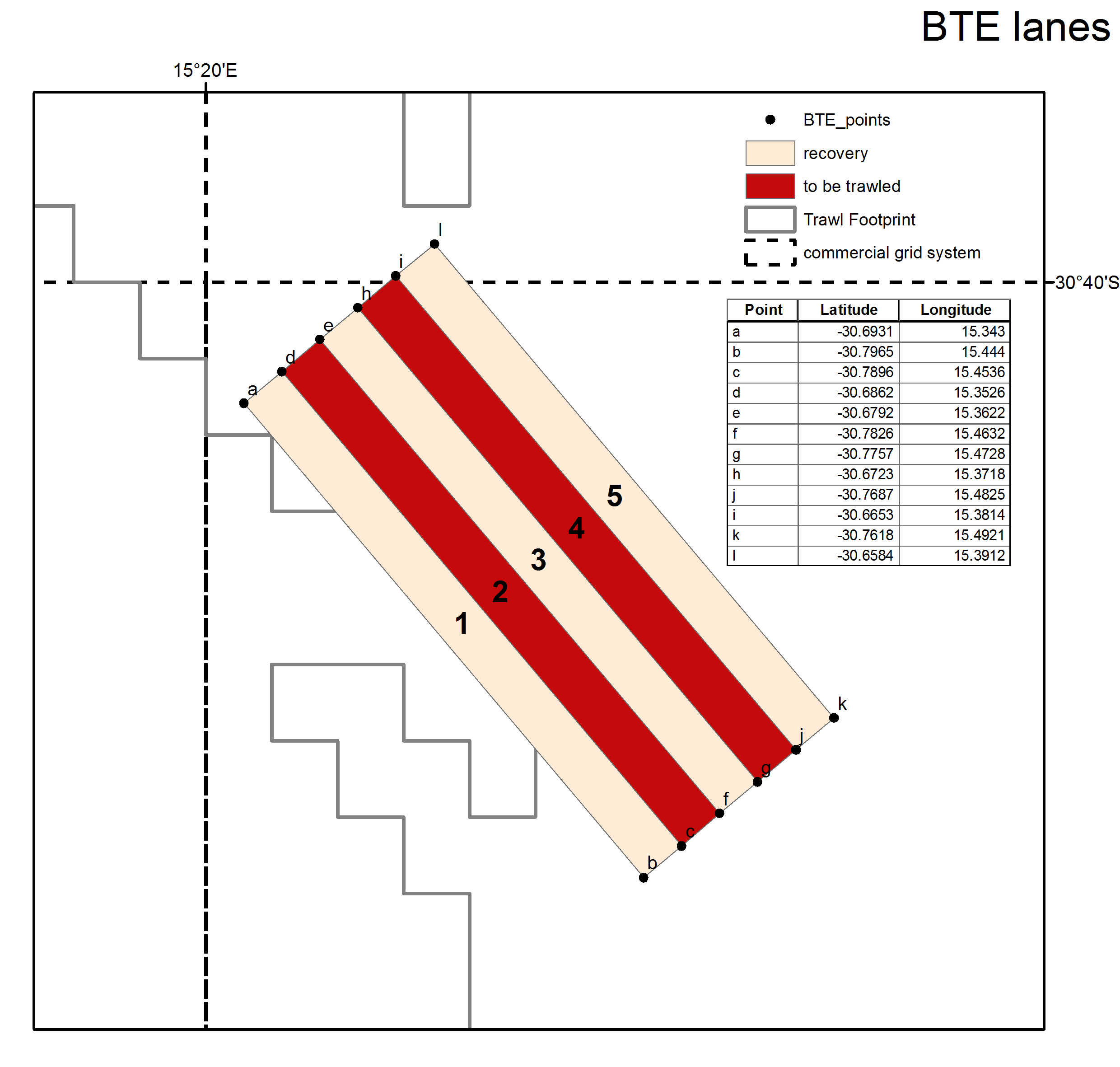
The experimental survey area lies west of Hondeklip Bay, off the west coast of South Africa, near the edge of the continental shelf at approximately 480 m depth. The site consists of 15 x 6 km trawl lanes.
-
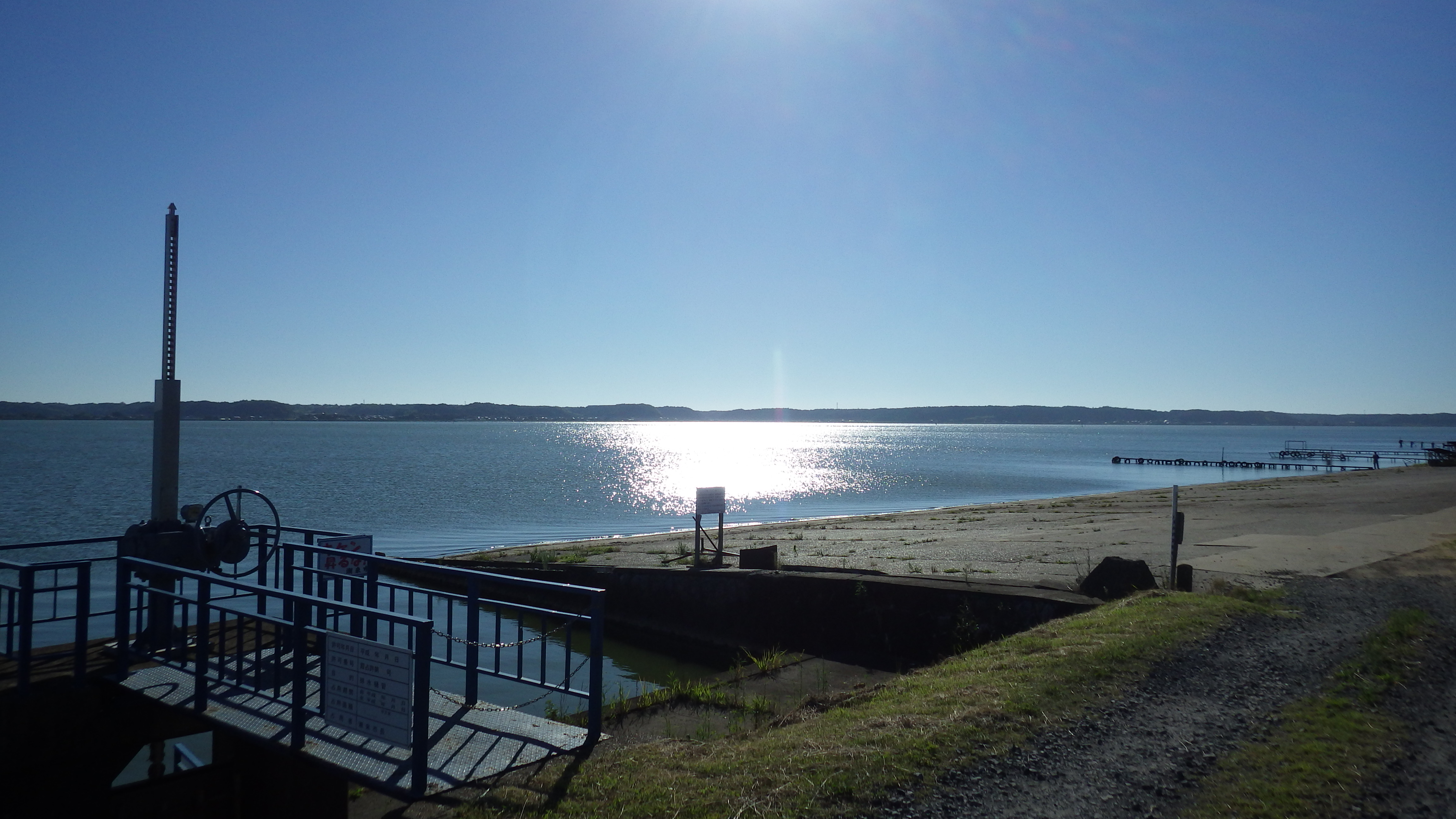
Lake Kitaura is typical eutrophic lake in Japan. The maximum and average depth is 10 m and 4.5 m, respectively.
-
The introduction of non-indigenous species (NIS), also known as alien species, is a pressing issue throughout the world nowadays, mostly linked to globalization. Transitional environments are particularly exposed to this threat due to the importation of seafood for either aquaculture or sale. According to the most recent observations, the Mar Piccolo of Taranto hosts 36 NIS positively identified, divided in 13 invertebrates, 15 macroalgae, and 8 planktonic species. This basin ranks third among the Mediterranean hot spots for seaweed introduction, after the Thau Lagoon (southern France) and the Venice Lagoon. Continuous monitoring activities are carried out to early identify new introductions and follow the fate of those already introduced.
-
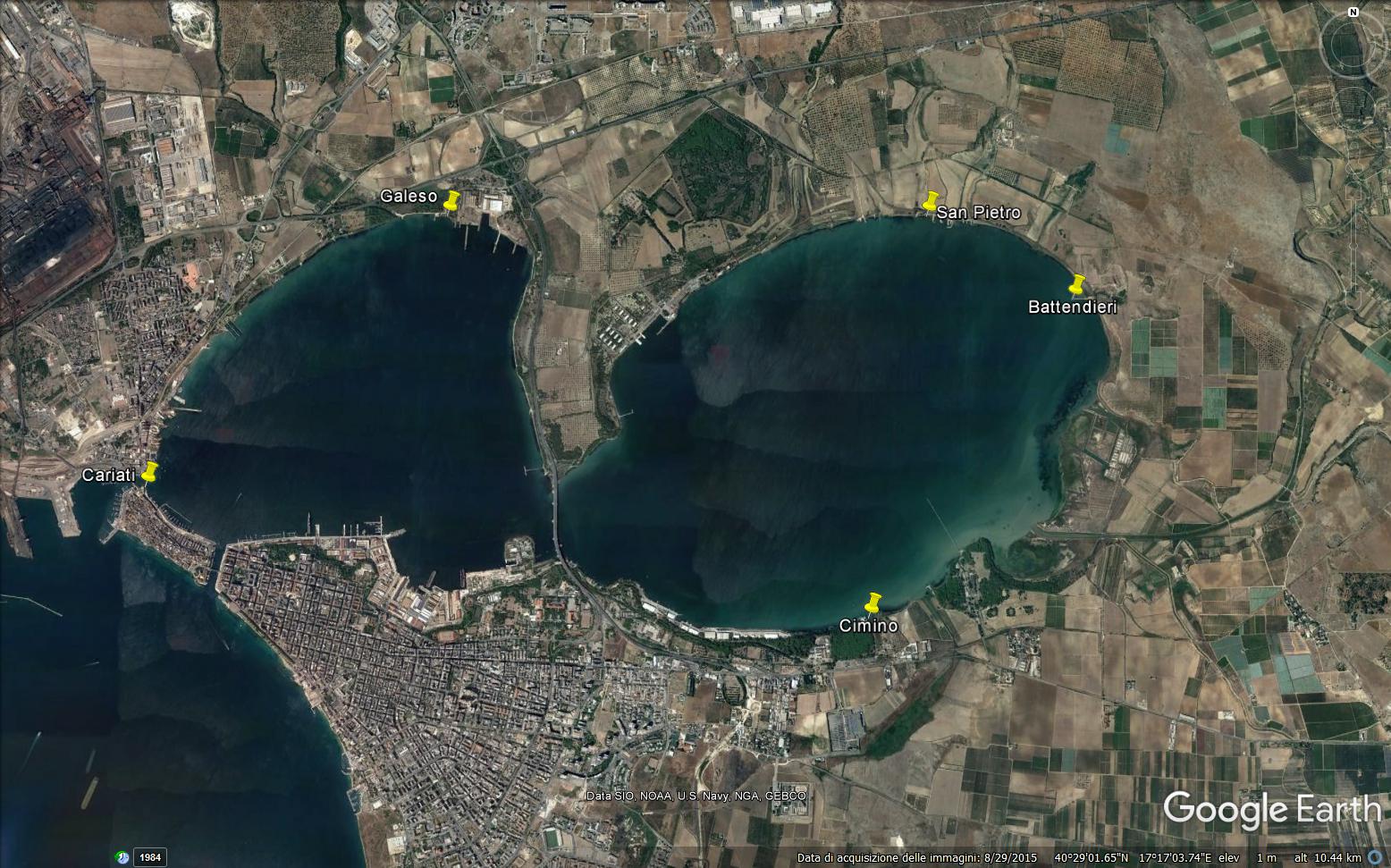
The Mar Piccolo is an inner, semi-enclosed sea located on the North of the town of Taranto showing lagoon features. It has a surface area of 20.72 Km2 and is divided by two promontories of land into two smaller inlets, called the First and the Second Inlet, which have a maximum depth of 12 and 8 m, respectively. Two canals, Navigable Canal (width 58 m, depth 12 m) and Porta Napoli Channel (width 48 m, depth 2.5 m), the most important for the water exchange, put the Mar Piccolo in communication with the nearby Mar Grande basin. The scarce hydrodinamism and the reduced water exchange, mainly in the Second Inlet, with the nearby Mar Grande determine the stratification of the water, especially in summer. Due to the strong anthropogenic impact, most of hard substrata are artificial. Soft substrata are sandy near the shore and muddy in the central zone of both Inlets. In the Mar Piccolo basin, tidal range is reduced, not exceeding 30-40 cm. Chemical-physical features of the basin, deeply studied in the last years, show a variable trend according to the seasons and to the Inlets. The two basins are characterized by different levels of confinement. Such a confinement is evident for chemichal-physical variables and let to immediately single out the two basins, as the variables values change moving from the First Inlet to the Second Inlet. Always along the same direction, besides the confinement, an evident increase of all the variables fluctuations is observable which points out a noticeable instability of the most confined basin. The lagoon features of the Mar Piccolo are mainly due to the presence of 34 submarine freshwater springs (locally called "Citri") of which 20 are in the First Inlet and 14 in the Second Inlet . The most important are “Galeso” (mean flow 600 L s-1) and “Citrello” (mean flow 350 L s-1) in the First Inlet and “Le Copre” (mean flow 80 L s-1) in the Second Inlet. The freshwater of the “Citri” has a uniform temperature of 18°C; therefore, they locally affect both the salinity and the temperature of seawater. Moreover, in the Mar Piccolo several small tributary rivers flow, of which the most important is “Galeso” (mean flow 50,000 m3day-1) in the First Inlet; other small rivers, less important because their flow is strongly affected by the seasons, are “Cervaro”, “Rasca” and “Rubafemmine” in the Second Inlet. Salinity ranges from 34.3 to 37.7. Seawater temperature ranges from 7.1°C to 33.6°C. Since the Mar Piccolo is an enclosed and therefore sheltered basin, it has been using for human activities for a long time. Indeed, it houses the biggest mussel farm in Italy with plants widely distributed in both the Inlets, which has a production of about 30,000 tons year-1 and employs about 800 people. Until few years ago, the most important Italian Navy base was located in the First Inlet of which only the dry-docks are still present. In addition, a small fishing fleet, of about 300 boats, is present in the First Inlet. The water-scooping machine of the steel industry catches seawater from the basin for the cooling plants. Moreover, the Mar Piccolo is subject to agricultural pollution because the irrigating waters of the surrounding fields flow into the basin by both the rivers and the submarine freshwater springs. Up to 2000, also 14 urban sewage outfalls flowed into the basin coming from some small cities near Taranto. Starting from this year, the outfalls of 11 of these were closed since their seawage pipes were connected to Bellavista depuration plant flowing outside the Mar Grande basin; currently, only 5 seawage outfalls (1 in the First Inlet and 4 in the Second Inlet) till flow into the basin. Therefore, the discharging of waste waters in the basin has noticeably been reduced.
-
The Alimini Grande Lake has an elongate shape that develops almost parallel to the Adriatic coastline and overall its extension is 1,37 sqkm. It is linked to the Alimini Piccolo by a canal called Lu Strittu, 1300 metres long and from 10 up to 30 meters wide. The chemical-physical characteristics of the waters such as temperature, salinity and dissolved oxygen concentration have been studied for long time. The average salinity is 26.8 with a minimum of 2.7 in winter and a maximum of 41 in summer. Regarding the temperature, it shows the typical seasonal trend with the least minimum temperature recorded between December and January. The freshwater inflow from Traugnano, Strittu e Zuddeo canals descharges a load of nutrients collected from the catchment area surrounding Alimini Grande. Nevertheless on the basis of the measured nitrogen and phosphorus concentrations the lagoon can be considered mesotrophic, due to the water turnover and above all to the assimilation of nutrients by phytoplankton and bacteria. The lagoon is a nutrient trap, the rates of nitrogen and phosphorus salts in entrance are bigger than those exiting in the sea. For this reason, the lagoon has a relevant ecological function, confining and transferring the nutrients through the food webs within the area and acting as an ecological filter for the marine ecosystems. The Alimini Grande catchment basin has a surface of approximately 71 sqkm and almost 94% of the catchment basin (66 sqkm) is cultivated above all with olives and other sowing fields, requiring more than 300 tonnes per year of fertilizers (nitrogen and phosphorus total) and 3 tonnes of pesticide. The agricultural areas and the artificial surfaces as urban and industrial centers could have a potentially adverse impact on the lagoon because of the run-off waters inflowing through the hydrographic basin that provide high nutrient quantity, organic material and other pollutants. The lagoon is included in the Site of Community Importance (SCI) “Laghi Alimini” (CODE IT9150011) of the “Natura 2000 network”, according to the Habitat Directive 92/43/CEE. Some of the habitats of the lagoon are typical of the dune ecosystem and are of high naturalistic value, as the coastal dunes with junipers considered of priority interest, being present in less than 5% of the EU territory. The Alimini Lake biodiversity is so extraordinary that includes more than half of the vegetable species in Salento. The area is internationally known as located on the avifauna migratory route towards the northern Adriatic coast. In the last years the quantity and the diversity of wintering and migratory aquatic birds, such as the Mallard, Pochard, Coot and other Anatidae have been increasing.Currently the Alimini Lakes are subjects of study by the Department of Biological and Environmental Sciences and Technologies of the University of Salento aiming at the improvement of basic and applied ecological research activities on transitional waters.
-
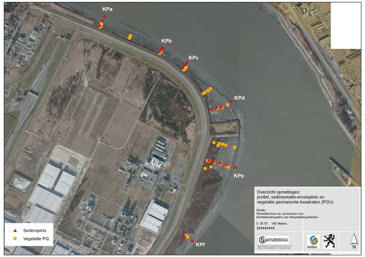
The site is a managed realignement (Sea Wall Removal) combined with a land lowering to start estuarine development in a suitable tidal frame. The site was created in 2002 and monitored in an initial phase intensively. (aspects of morphology, sediment characteristics (including polluents), macrozoobenthos, vegetation and birds). Vegetation and birds are ongoing monitoring.
-
UK Upland Waters Monitoring Network (UK UWMN) site. Loch Coire Fionnaraich has a catchment of 550 ha, with a range of elevation from 236 m at the outflow to 933 m at the summit of Maol Chean-dearg. Whilst a band of Cambrian basal quartzite and "Pipe Rock" crosses beneath the northern side of the loch, the catchment geology is mostly made up of Torridonian sandstones from the Applecross and Aultbea groups. Catchment soils consist of peats and peaty podsols alongside extensive areas of exposed rock. Vegetation is dominated by Molinia and Calluna and the catchment is treeless. The surrounding moorland is managed for red deer and low numbers of feral goats are also present. A popular hiking path passes along the western shore of the loch. There are a number of very small lochans and pools on the catchment's northern boundary and one more in the north-west.
-
UK Upland Waters Monitoring Network (UK UWMN) site. Named Lochan a' Cheaird on historic maps, Loch Tinker lies at 418 m altitude and drains an adjacent catchment to the east of Loch Chon in the Trossachs region of central Scotland. The loch receives drainage from seepage through the catchment blanket peats and from the steep slopes to the south and east, although the main stream in this area is naturally captured just a few metres downstream of the loch outflow. The loch drains to the north east via the Allt Glasahoile which falls steeply to Loch Katrine. The loch (surface area 11.1 ha) has an irregular shoreline and the generally shallow (mean depth 3.5 m) bathymetry includes two distinct sub-basins reaching a maximum depth of 9.8 m. Three small islands are located towards the southern end of the loch. Some data managed by UK ECN Data Centre. Note: The area is the size of the catchment.
-
UK Upland Waters Monitoring Network (UK UWMN) site. Loch Chon is a relatively large (surface area 105.7 ha) lake lying at an altitude of 92 m in the Trossachs region of central Scotland. The loch is fed by several small streams and drains to the south via Loch Ard and the River Forth. The loch has two main basins, with the deepest area (25 m) represented by a trench near the western shore. The bathymetry was first surveyed by Murray and Pullar in 1910. Some data managed by UK ECN Data Centre. Note: The area is the size of the catchment. The lake area is 106 ha
-
UK Upland Waters Monitoring Network (UK UWMN) site. The site lies at 298 m altitude in the Galloway region of south-west Scotland. The loch is 12.7 ha in area and receives drainage from minor streams and catchment blanket peats. The outflow drains to the south-west into the Glenhead Burn and Loch Trool. The loch bathymetry indicates a single deep basin (maximum depth 13.5 m) offset to the south with slopes rising gently away from the southern shore. An island is located just off the western shore some 250 m from the outflow. Some data are managed by UK ECN Data Centre. Note: The area is the size of the catchment.