
biodiversity loss
Type of resources
Available actions
Topics
Keywords
Contact for the resource
Provided by
Years
Formats
Representation types
-
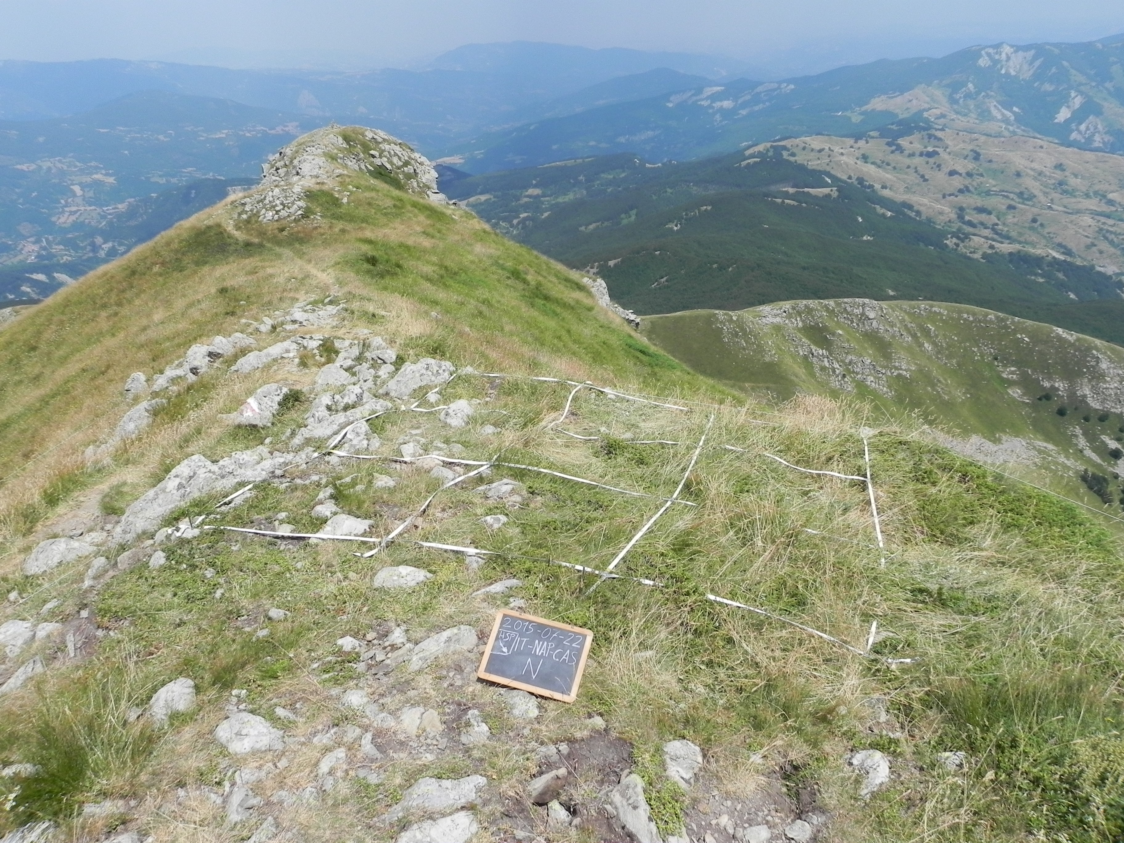
The site consists of “orographic islands” with high elevation vegetation in central Mediterranean basin, along the Apennines mountain range, within the Appennino Tosco-Emiliano National park and partially in the Appennino Modenese Regional park. It includes 64 permanent plots for plant species monitoring, distributed from timberline zone to the subalpine/alpine belt (1722-2000 m), that belong to the GLORIA project’s world network (GLobal Observation Research Initiative in Alpine ecosystems); The plots lie at the top of four summits, displayed along an altitudinal gradient, chosen following the GLORIA Target Region selection criteria. Furthermore, other 26 permanent plots, detached from the GLORIA project, have been settled on mount Prado. The observation and the long-term monitoring of vegetation and alpine plant species population started in 1999. The collection of soil temperature and osmotic potential started in 2001 and 2013, respectively. The site is resurveyed regularly to collect vegetation data (in term of presence/absence and coverage) and climatic data (temperature and osmotic potential data series recorded every 30 minutes by data loggers) in order to assess impacts of climate change on plant communities and single plant species of interest.
-
Processing of time series of satellite and airborne images, with different spatial and spectral resolution, in order to derive water quality maps based on physically based algorithms parametrised with specific optical properties of lake Garda. Generation of spatial and temporal information of different water quality parameters of surface water column and coastal zone. Dedicated actives of calibration and validation of satellite images, algorithms and products.
-

The site corresponds to the territory of Gran Paradiso National Park. This includes different ecosystems, present along the altitudinal gradient (ca. 800 – 4000 m asl): the woody areas of the montane belt, the ecotonal habitats of the subalpine belt and the meadows of the alpine one. The nival belt is widely represented inside the Park. The habitats with poor or no vegetation (rocks, screes, glaciers) cover about 60% of the territory, meadows and pastures 17%, about 20.2% is characterised by woods and shrubs, while 0.8% by cultivated lands and urban areas. The aquatic ecosystems, beyond the streams, comprise almost 15 lakes, bigger than 10,000 m2 and located at an altitude higher than 2000 m asl. The area is directly managed by the Park Authority; research and monitoring activities are coordinated by the Sanitary and Scientific Office of the Park.
-
How do freshwater ecosystems react to changing environmental conditions and to what extent can these changes be captured in the dynamics of eco-evolutionary processes? The project REES ('Rhine Eco-Evolutionary System') aims at the long-term assessment of eco-evolutionary interactions in the Rhine as a limnic habitat under consideration of diverse associated water bodies. The study area includes the main flow channel of the Rhine (km 845, North Rhine-Westphalia), as well as Rhine oxbows, Rhine water-fed gravel pit lakes in ecological succession and the surrounding floodplain (Rees, district of Kleve). The Ecological Research Station Rees-Grietherbusch of the Institute of Zoology (University of Cologne) and the Nature Conservation Center District Kleve e.V. form the central infrastructure of the study area. In addition, the Ecological Rhine Station of the University under the direction of Prof. Dr. Arndt is also associated to the project, which enables direct sampling and experimental recording of the main Rhine flow channel. The extensive system of standing and flowing freshwater bodies covered in the REES study site allows the investigation of dynamic variations in biodiversity composition at all levels, from species diversity of communities to genomic diversity at the molecular level of individuals and populations. Along a selected trophic cascade, representative species will be long-term observed and analyzed ecologically and especially also (population-)genomically. The incorporation of ecological genomics is the core aspect of this LTER-D project, which is intended to capture the feedback of evolutionary changes on the ecological system. Population genomic approaches can be used to infer both evolutionary and ecological processes from genomic data. To cope with the dimension of this project, REES is designed as an interdisciplinary collaboration project and currently counts seven project partners with corresponding subordinate projects.
-
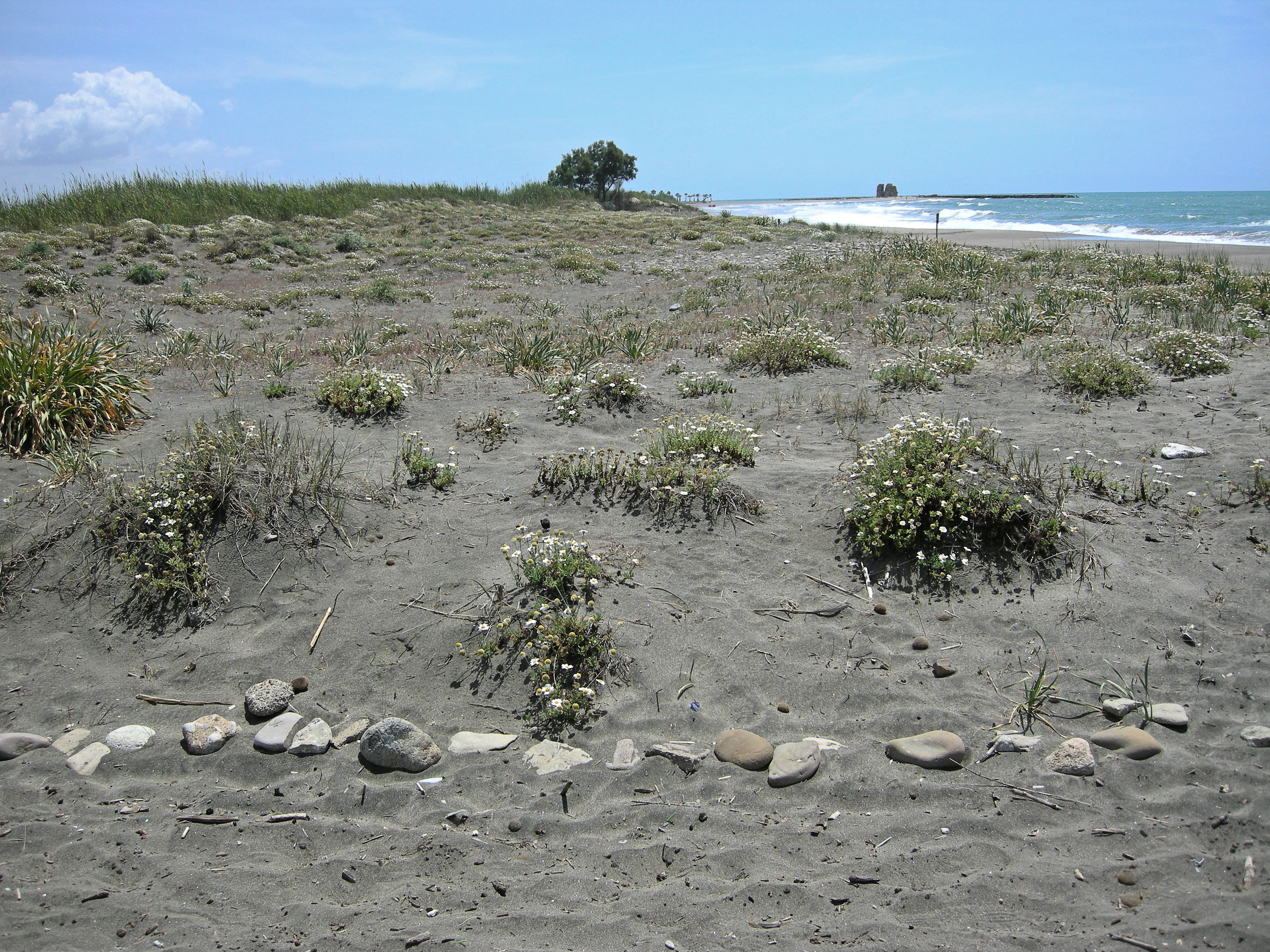
The site, located along the Tyrrhenian coast, north of Rome city, is a Special Protection Area (SPA) for migratory and nesting birds (Anatidae, Ardeidae). The wetland area is one of the last stretches of the Lazio wetlands which have been progressively reclaimed and cultivated during the last century. The flora and the fauna of the site is not only highly specialized but also highly endangered, with a relevant ecological value evidenced in previous studies. The site includes coastal dune habitats of European interest, as the annual vegetation of drift lines, the embryonic shifting dunes, the mobile dunes with Ammophila arenaria and the dune grasslands. There are also habitats related to wet and mud soils, as Mediterranean salt meadows and reed beds dominated by Phragmites australis.
-
LTER plot Thermophilous forests includes five regions and sixteen localities in Central Bohemia and Southern Moravia, where ecosystems of thermophilous forests, including adjacent natural treeless vegetation, have been studied for a long time. The monitoring is run jointly by the Institute of Botany of the Czech Academy of Sciences (coordination R. Hédl) and the Silva Tarouca Research Institute for Landscape and Ornamental Gardening (coordination D. Adam). The main focus is on the plant community, including trees and herbs, which are monitored by using sets of permanent plots, or as continuous forest stands. Data are collected at the level of individuals (plants), plant communities (species composition and biodiversity) and ecosystem (soil, canopy, microclimate and other variables). The backbone of the monitoring system consists of nearly 500 long-term monitoring plots. These are supplemented by several dozens of short-term monitoring plots, and historical plots resurveyed only once after several decades. The monitored forest stands share similar natural conditions and management history. They cover a wide range of thermophilous forest communities, mainly thermophilous oak-hornbeam forests, various types of oak and ravine forests, occasionally beech forests and the adjacent open habitats (rocky steppes). The dominant type of management was coppicing in most sites, mainly as coppices-with-standards. The historical management was abandoned during the 19th and early 20th centuries, and the monitored ecosystems were managed with a decreasing intensity in about the past half a century. Some of the localities or their parts are subject of non-intervention regime at present. This has affected the age of the forest stands, which has increased by several times. Today, many stands are 100+ years old. All monitored localities are parts of conservation areas, often multiple combinations - national nature reserves (NNR), national nature monuments (NNM), nature reserves (NR), national park (NP), protected landscape area (PLA), EU Site of Community Importance (SCI). The main strategy of the nature conservation is the management reduction at most sites. In several cases, however, restoration of the traditional ways of forest management has been introduced in the past years. The Thermophilous forests site consists of the following five areas and sixteen localities: 1. Křivoklátsko Protected Landscape Area Monitoring of the dynamics of tree communities (including 3D scanning), vegetation including the communities of vascular plants, fungi, saproxylic beetles and soil processes. Data are available from 1976, 1999, 2004 and annually since 2004 (localities Velká Pleš and Týřov), or since 1993 (locality Červený kříž) - Velká Pleš: 10 ha of continuous forest stand monitoring, 400 microplots (20 x 20 cm) and monitoring of game impact on rocky steppes (pleše = balds). - Týřov: 400 microplots (20 x 20 cm) in xerothermic treeless habitats and in enclosures. - Červený kříž: focus on the impact of game on the diversity of plant communities. 2. Český kras Protected Landscape Area Monitoring of the dynamics of plant communities, soil and tree overstory in five-year intervals, using a network of 190 permanent plots. Microclimatic measurements in part of the plots. Data from 2005, 2009, 2014, 2019. Focus on the tree dynamics at one locality (Doutnáč). Part of the area left for spontaneous development, part subject of the traditional management restoration. Additionally, 57 historical vegetation plots resurveyed after 50 years. - Karlštejn NNR: three localities Prostřední vrch, Vysoká stráň and Doutnáč; collective area 166 ha. - Koda NNR: three localities Tobolský vrch, Za lípou and Kodská stěna, collective area 95 ha. 3. Podyjí National Park Monitoring of the dynamics of several forest ecosystem components, focusing on natural processes and the restoration of traditional management forms. Continuously measured tree stands, yearly monitoring of plant communities, invertebrates, bryophytes, snails, fungi and soil variables by using a network of plots. Data available from 2010 and 2014-onwards. A network of 50 permanent plots with five-year monitoring interval was established in 2018. - Four localities in the eastern part of the national park: Lipina, Šobes, Popice and Hnanice, collective area 309 ha. 4. Pálava Protected Landscape Area Monitoring of the dynamics of plant communities, soil and tree overstory in five-year intervals, using a network of 160 monitoring plots. Microclimatic measurements in part of the plots. Monitoring of spider, beetle and ant communities in addition to that. Data available from 2008-onwards. Next to it, about 230 historical vegetation plots resurveyed after 50-60 years, and a detailed research on the management history. - Děvín NNR: 380 ha, 85 permanent plots and about 180 resurveyed historical plots. - Milovický les: 2051 ha, 75 permanent plots a 46 resurveyed historical plots. 5. Dúbrava Monitoring of the dynamics of plant communities, soil and tree overstory in five-year intervals, using a network of 75 monitoring plots. Data from 2011, 2012 and 2017. In addition to that, 56 historical vegetation plots resurveyed after 50 years, covering a larger area. Detailed research on the management history and a paleoecological research covering the entire Holocene. - Hodonínská Dúbrava: 4820 ha, 75 permanent plots and 56 resurveyed historical plots.
-
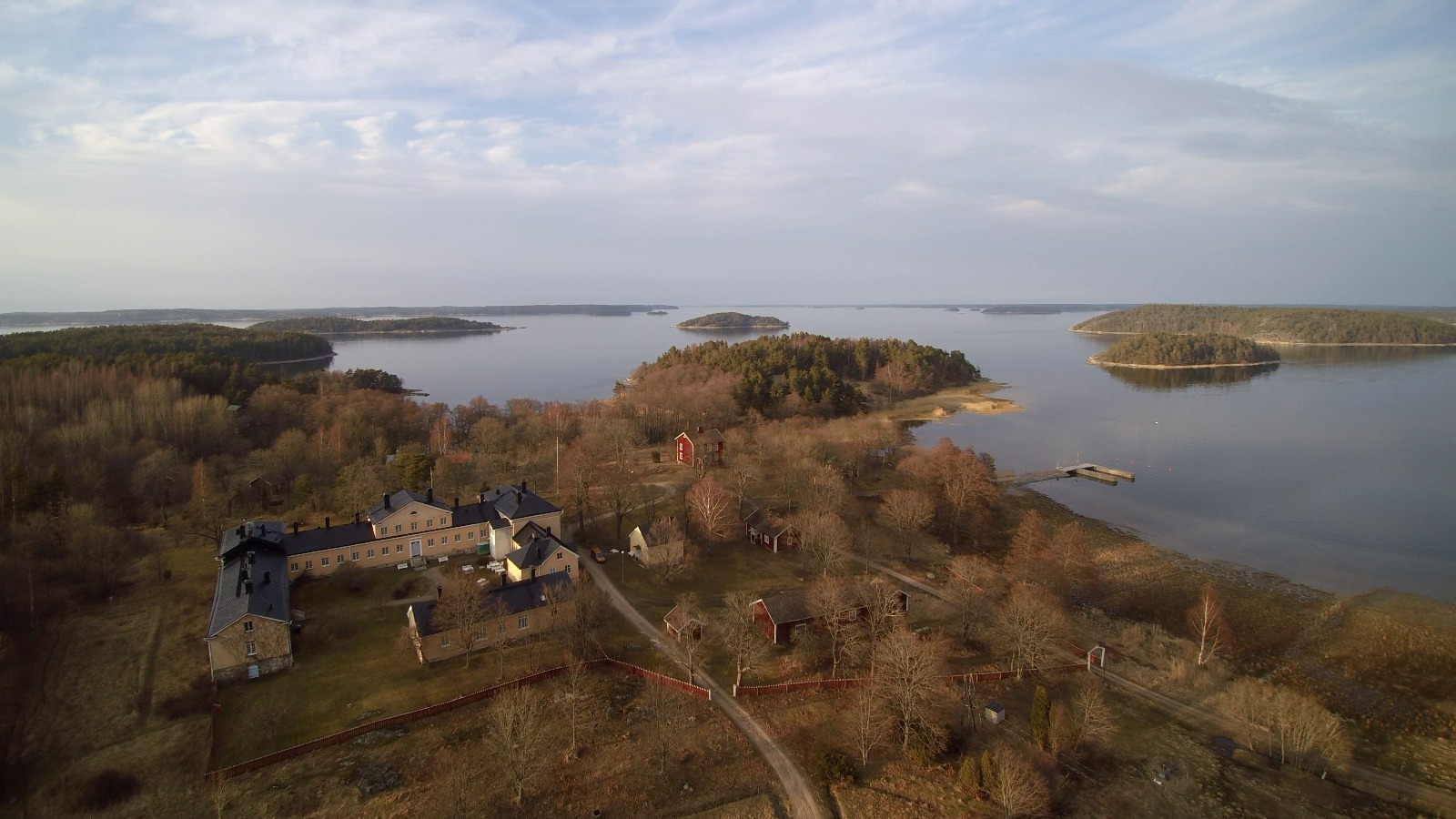
The Archipelago Research Institute is a historical marine station at the island of Seili, located in the middle of the Turku archipelago. The Institute offers various research support services as well as participates in multidisciplinary research of the Baltic Sea, with a special focus on the condition of the Archipelago Sea. The station is open for researchers and visitors year-round.
-
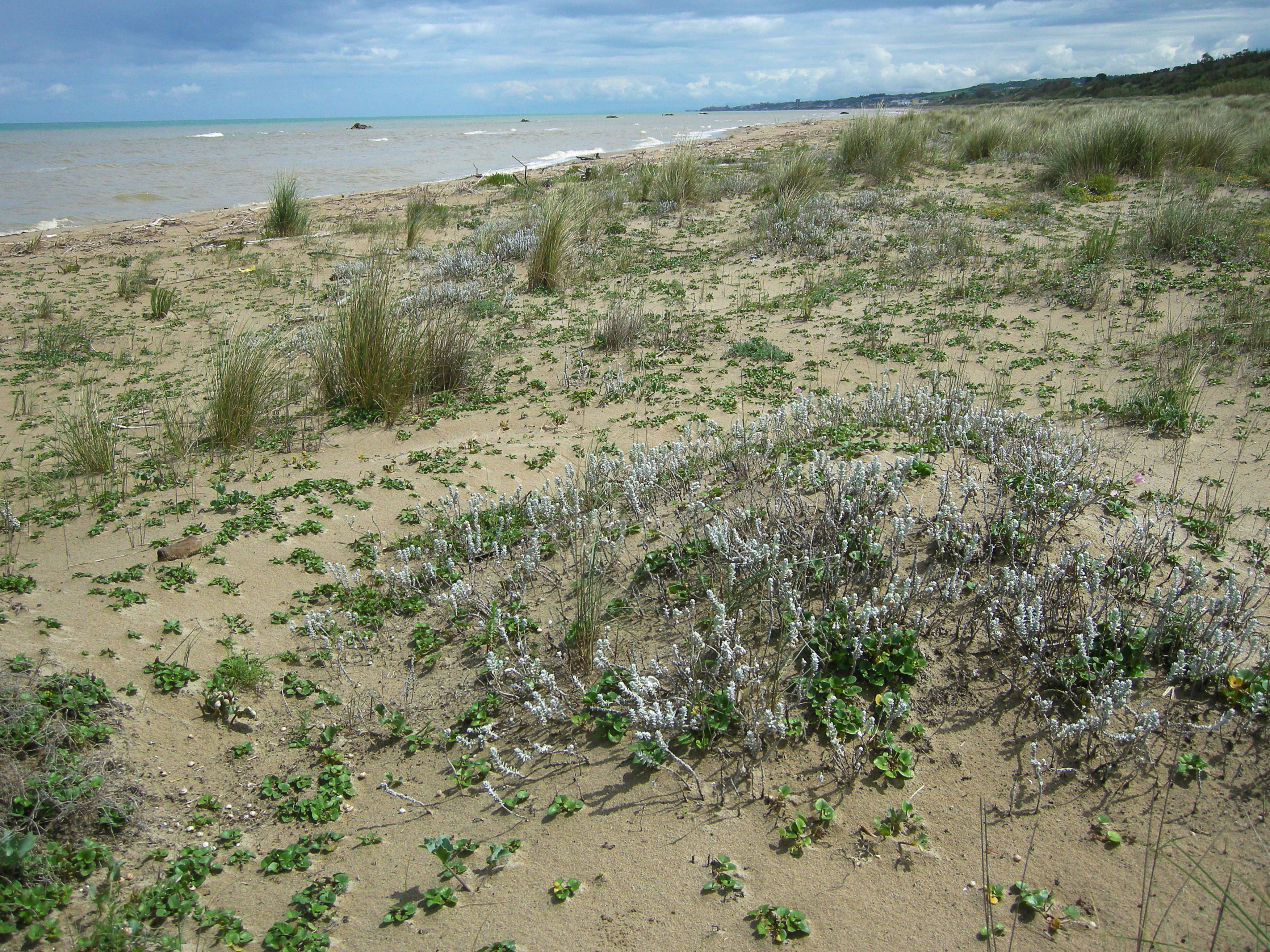
S.C.I IT7228221 Foce Trigno-Marina di Petacciato (Campobasso) S.C.I. IT7140108 Punta Aderci-Punta della Penna S.C.I. IT7140109 Marina di Vasto The site includes 3 Natura 2000 sites along the central Adriatic coast, where the last fragments of natural vegetation zonation on sand coastal dunes occur (shore vegetation, embryo and mobile dune vegetation, annual Mediterranean grasses and wet dune slacks).
-
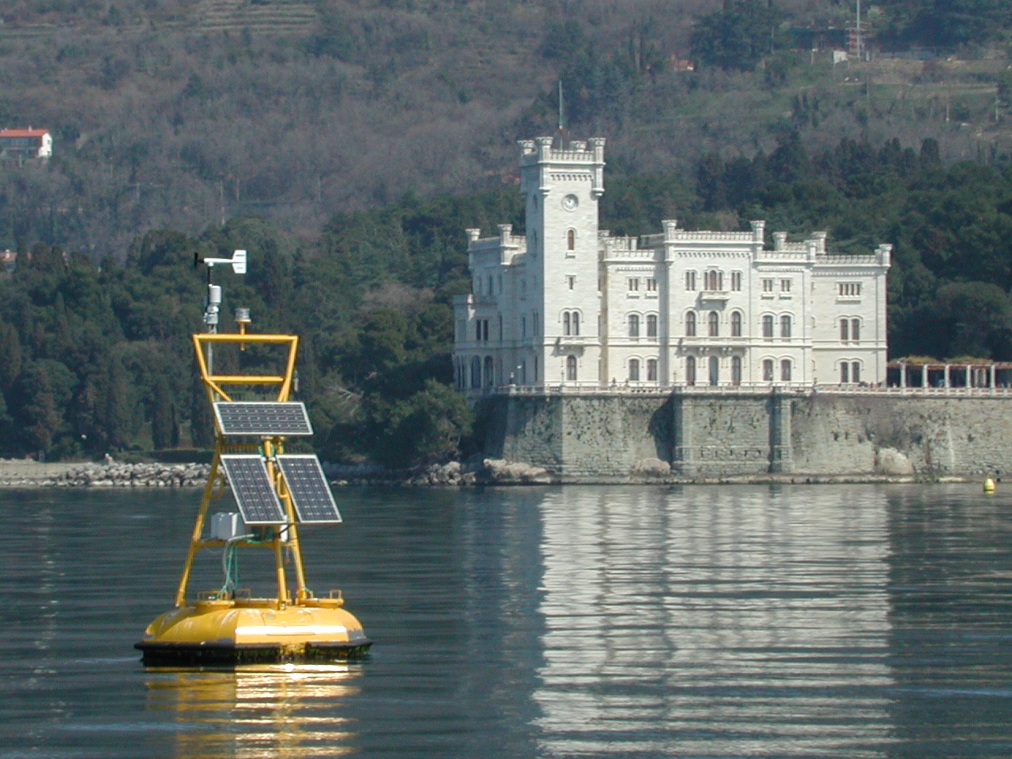
The coastal marine observatory site Gulf of Trieste lies within the Marine Protected Area (MPA) of Miramare and includes the biological time-series station “C1”, part of the Italian Long-Term Ecological Research (LTER) network, and the in situ continuous MAMBO meteo-oceanographic buoy. Marine Protected Areas represent one of the most effective systems for marine biodiversity preservation and management. Since 1986, the time-series station “C1” in the Gulf of Trieste (GoTTs, Gulf of Trieste Time series) represents a crucial site for marine ecological research, as it is subject to the interaction among several natural forcing (river, groundwater discharge, tides, general circulation, intense meteorological) and numerous anthropogenic activities (maritime transport, harbours of Trieste and Monfalcone, urban waste discharge, mussel- and fish-farming, fishing and recreational activities). In 1999, the ecological research site has been equipped with a meteo oceanographic buoy (MAMBO) in order to acquire continuous data on meteorological conditions at sea and on seawater physical and biogeochemical properties. Due to the high temporal dynamics of ecological processes in coastal ecosystems, continuous and real-time data of the main meteorological, physical and biogeochemical properties are fundamental for a better understanding of marine ecosystem functioning.
-
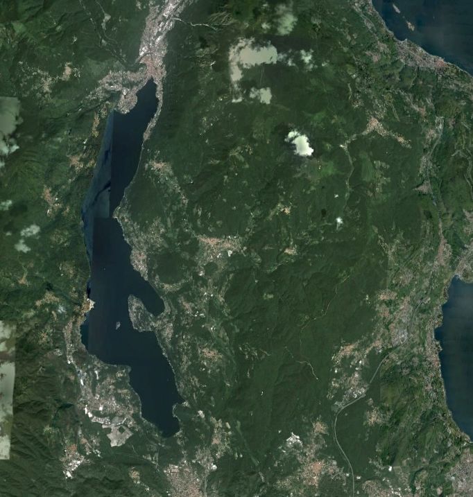
Lake Orta is a deep subalpine lake, located in Northern Italy, at a mean altitude of 290 m a.s.l. Its perimeter is 33,8 km, surface area 18,14 km2, volume 1,29 km3. Lake Orta has a maximum depth of 143 m and a mean depth of 71 m. Lake Orta is well known for being polluted by industrial discharges (copper sulphate and ammonia) since the late 1920: as a consequence, the pH of the lake water dropped down till 4 and the food web was almost completely destroyed, except for some few, strongly adapted species. The pollution stopped around mid 1980s and a liming intervention was carried out in 1989-1990, to neutralize the acidic waters of the lake. The recovery was very fast, new species started to colonise the lake just after the liming. The lake, however, is still at risk, due to the large amount of heavy metals stored in the sediments.