
biological diversity
Type of resources
Available actions
Topics
Keywords
Contact for the resource
Provided by
Years
Formats
Representation types
-
The introduction of non-indigenous species (NIS), also known as alien species, is a pressing issue throughout the world nowadays, mostly linked to globalization. Transitional environments are particularly exposed to this threat due to the importation of seafood for either aquaculture or sale. According to the most recent observations, the Mar Piccolo of Taranto hosts 36 NIS positively identified, divided in 13 invertebrates, 15 macroalgae, and 8 planktonic species. This basin ranks third among the Mediterranean hot spots for seaweed introduction, after the Thau Lagoon (southern France) and the Venice Lagoon. Continuous monitoring activities are carried out to early identify new introductions and follow the fate of those already introduced.
-
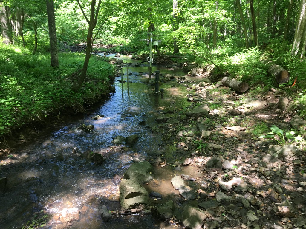
The Posey Creek (POSE) core aquatic site is part of NEON's Mid-Altantic Domain 2 sites. POSEY is a wadeable stream near Front Royal, VA and is located on the Smithsonian Conservation Biology Institute land. It is a shallow stream (<40 cm at average flow) and 3 - 5 m wide (6 meters wide during high flows). This site has one meteorological station located in the riparian area. The met station is outfitted with a subset of the same sensors used at terrestrial sites. Measurements include wind speed and direction, air temperature, barometric pressure, relative humidity, shortwave radiation, and PAR. This site has one upstream sensor station and one downstream sensor station. Measurements include PAR, temperature, water quality [specific conductivity, chlorophyll a, dissolved oxygen content, pH, turbidity, and fluorescent dissolved organic matter (only downstream)], and nitrate is measured at the downstream station. Eight groundwater wells throughout the site collect specific conductivity, water tempertaure, and elevation of groundwater. Field ecologists collect the following types of observational data at this site: aquatic organisms (Aquatic Microbes (surface water), macroinvertebratesmicroalgae, plants and macroalgae, zooplankton. Biogeochemical data on plants,sediment water and particulates. As well as physical aquatic data on bathymetric maps, stage,secchi depth and depth profiles, and riparian assessment. Total data products planned for this site: 78
-
The study of the plankton cyst bank from the Mar Piccolo of Taranto started in 1996 and is still ongoing. Different stations located in the two sub-basins basin are intermittently sampled, collecting surface sediments for cyst analysis. The identification of more than 100 different morphotypes was performed over the years.
-
The analyses are focused on monitoring coastal sand dunes landscape (mapping) of the central Adriatic area, which are representative of Mediterranean dune ecosystems and are partially included in the long-term ecological monitoring network (LTER - site code: LTER_EU_IT_081). Based on the use of specific GIS software and integrating photo-interpretation and classification of remotely sensed data, the study depict multi-temporal changes by mapping and updating land cover and vegetation information (1954- to date) of the cast of south Abruzzo and Molise regions. Specific attention is given to the identification of the seashore, dune habitats (coastal plant communities) and land cover types at a detailed spatial scale (1:5000).
-
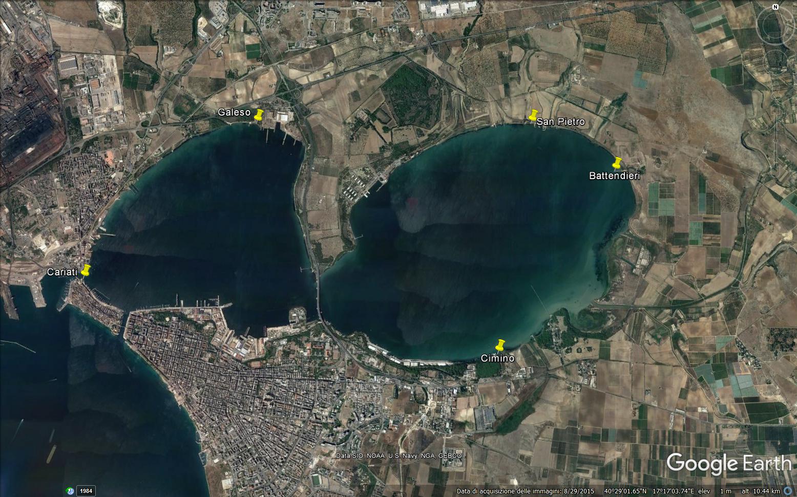
The Mar Piccolo is an inner, semi-enclosed sea located on the North of the town of Taranto showing lagoon features. It has a surface area of 20.72 Km2 and is divided by two promontories of land into two smaller inlets, called the First and the Second Inlet, which have a maximum depth of 12 and 8 m, respectively. Two canals, Navigable Canal (width 58 m, depth 12 m) and Porta Napoli Channel (width 48 m, depth 2.5 m), the most important for the water exchange, put the Mar Piccolo in communication with the nearby Mar Grande basin. The scarce hydrodinamism and the reduced water exchange, mainly in the Second Inlet, with the nearby Mar Grande determine the stratification of the water, especially in summer. Due to the strong anthropogenic impact, most of hard substrata are artificial. Soft substrata are sandy near the shore and muddy in the central zone of both Inlets. In the Mar Piccolo basin, tidal range is reduced, not exceeding 30-40 cm. Chemical-physical features of the basin, deeply studied in the last years, show a variable trend according to the seasons and to the Inlets. The two basins are characterized by different levels of confinement. Such a confinement is evident for chemichal-physical variables and let to immediately single out the two basins, as the variables values change moving from the First Inlet to the Second Inlet. Always along the same direction, besides the confinement, an evident increase of all the variables fluctuations is observable which points out a noticeable instability of the most confined basin. The lagoon features of the Mar Piccolo are mainly due to the presence of 34 submarine freshwater springs (locally called "Citri") of which 20 are in the First Inlet and 14 in the Second Inlet . The most important are “Galeso” (mean flow 600 L s-1) and “Citrello” (mean flow 350 L s-1) in the First Inlet and “Le Copre” (mean flow 80 L s-1) in the Second Inlet. The freshwater of the “Citri” has a uniform temperature of 18°C; therefore, they locally affect both the salinity and the temperature of seawater. Moreover, in the Mar Piccolo several small tributary rivers flow, of which the most important is “Galeso” (mean flow 50,000 m3day-1) in the First Inlet; other small rivers, less important because their flow is strongly affected by the seasons, are “Cervaro”, “Rasca” and “Rubafemmine” in the Second Inlet. Salinity ranges from 34.3 to 37.7. Seawater temperature ranges from 7.1°C to 33.6°C. Since the Mar Piccolo is an enclosed and therefore sheltered basin, it has been using for human activities for a long time. Indeed, it houses the biggest mussel farm in Italy with plants widely distributed in both the Inlets, which has a production of about 30,000 tons year-1 and employs about 800 people. Until few years ago, the most important Italian Navy base was located in the First Inlet of which only the dry-docks are still present. In addition, a small fishing fleet, of about 300 boats, is present in the First Inlet. The water-scooping machine of the steel industry catches seawater from the basin for the cooling plants. Moreover, the Mar Piccolo is subject to agricultural pollution because the irrigating waters of the surrounding fields flow into the basin by both the rivers and the submarine freshwater springs. Up to 2000, also 14 urban sewage outfalls flowed into the basin coming from some small cities near Taranto. Starting from this year, the outfalls of 11 of these were closed since their seawage pipes were connected to Bellavista depuration plant flowing outside the Mar Grande basin; currently, only 5 seawage outfalls (1 in the First Inlet and 4 in the Second Inlet) till flow into the basin. Therefore, the discharging of waste waters in the basin has noticeably been reduced.
-
The analyses are focused on monitoring coastal sand dunes landscape (mapping) of the central Adriatic area, which are representative of Mediterranean dune ecosystems and are partially included in the long-term ecological monitoring network (LTER - site code: LTER_EU_IT_080). Based on the use of specific GIS software and integrating photo-interpretation and classification of remotely sensed data, the study depict multi-temporal changes by mapping and updating land cover and vegetation information (1954- to date) of the cast of south Abruzzo and Molise regions. Specific attention is given to the identification of the seashore, dune habitats (coastal plant communities) and land cover types at a detailed spatial scale (1:5000).
-
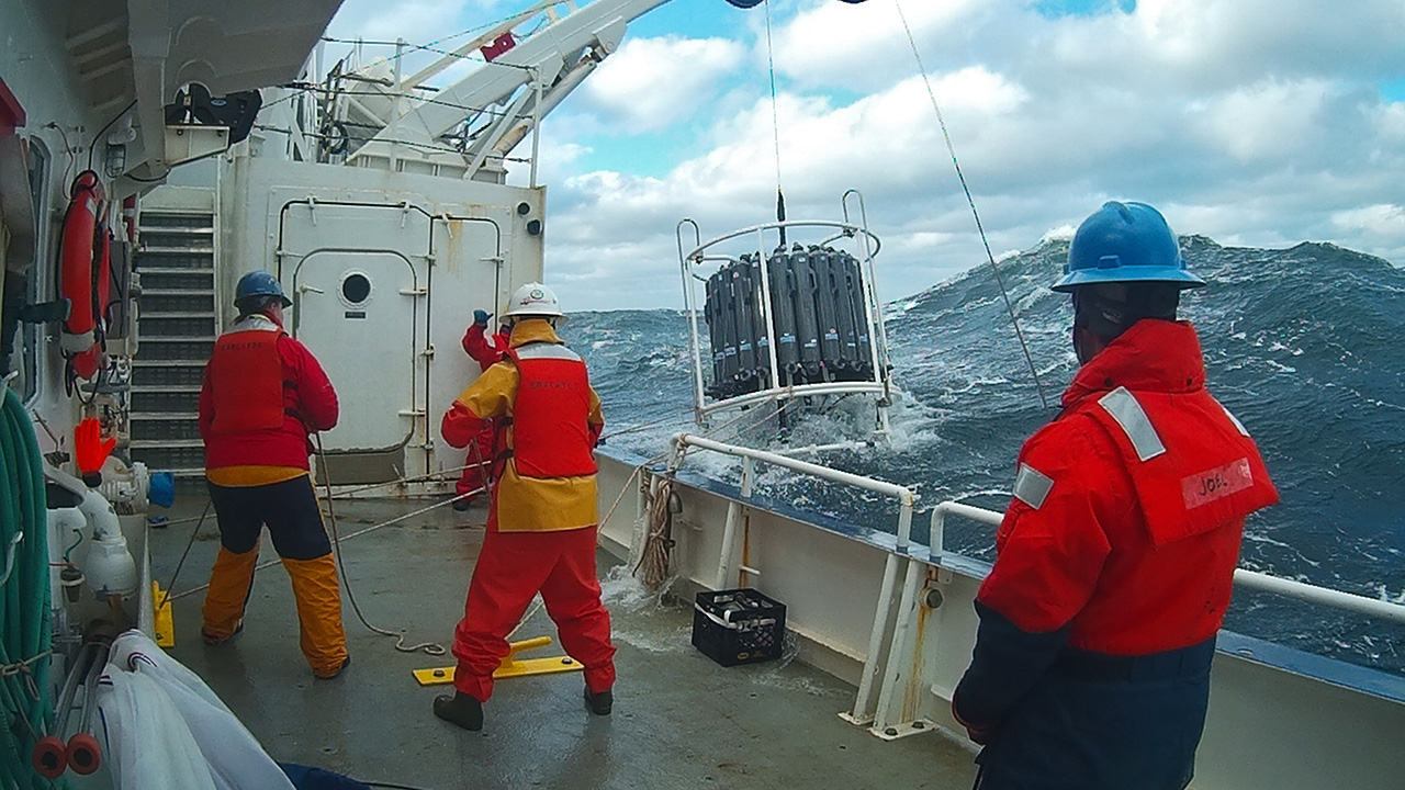
The Northeast US Shelf (NES) ecosystem spans the Middle Atlantic Bight and Gulf of Maine, is a large portion of the NW Atlantic Shelves Province, and is in a coastal biome. The waters over the NES provide an array of ecosystem services including fishing, energy development, shipping, waste disposal, recreation, and conservation. The NES ecosystem, like other productive temperate shelf ecosystems, is characterized by strong seasonality along with high levels of variability in physical forcing at timescales from days to decades, including climate impacts.
-
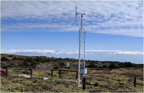
Mt Halla San is in Jeju Island, the only volcanic subtropical island, in South Korea. Every year the island is hit by several typhoons. It has shaped unique environmental characteristics and biodiversity. In addition the mountain is one of the most popular vacation sites with growing ecological concern.
-
Central Europe maintains a considerable diversity of dry-mesic oak forests as the main representatives of zonal forest vegetation types in Hungary, covering the major part of foothills of the middle-range mountain, Inner Western Carpathians. The 669 m high, Triassic limestone hill called ‘Vár-hegy’ belongs to the Bükk Mountains. The annual mean temperature is about 8◦C and the annual precipitation is about 650 mm. The core area of the reserve (94 ha) is covered mainly by close-to-nature. long untouched oak dominated forests stands: Pannonic woods with Quercus petraea and Carpinus betulus; Pannonian-Balkanic Turkey oak-sessile oak forests; Pannonian woods with Quercus pubescens. It has been set aside for preservation in 1991, though several previous conservation acts had already secured almost spontaneous natural development of the stands. Most of the area was cut around 1880, however, several over-mature trees were retained. The intensive use in the previous centuries and during the world wars left a sessile oak dominated, 120-130-year-old, mostly coppice forest. The abandonment and the precedent severe oak decline contributed to generate a more diverse forest composition and structure developing towards a mixed forest with pronounced ‘old-growth’ characteristics.
-
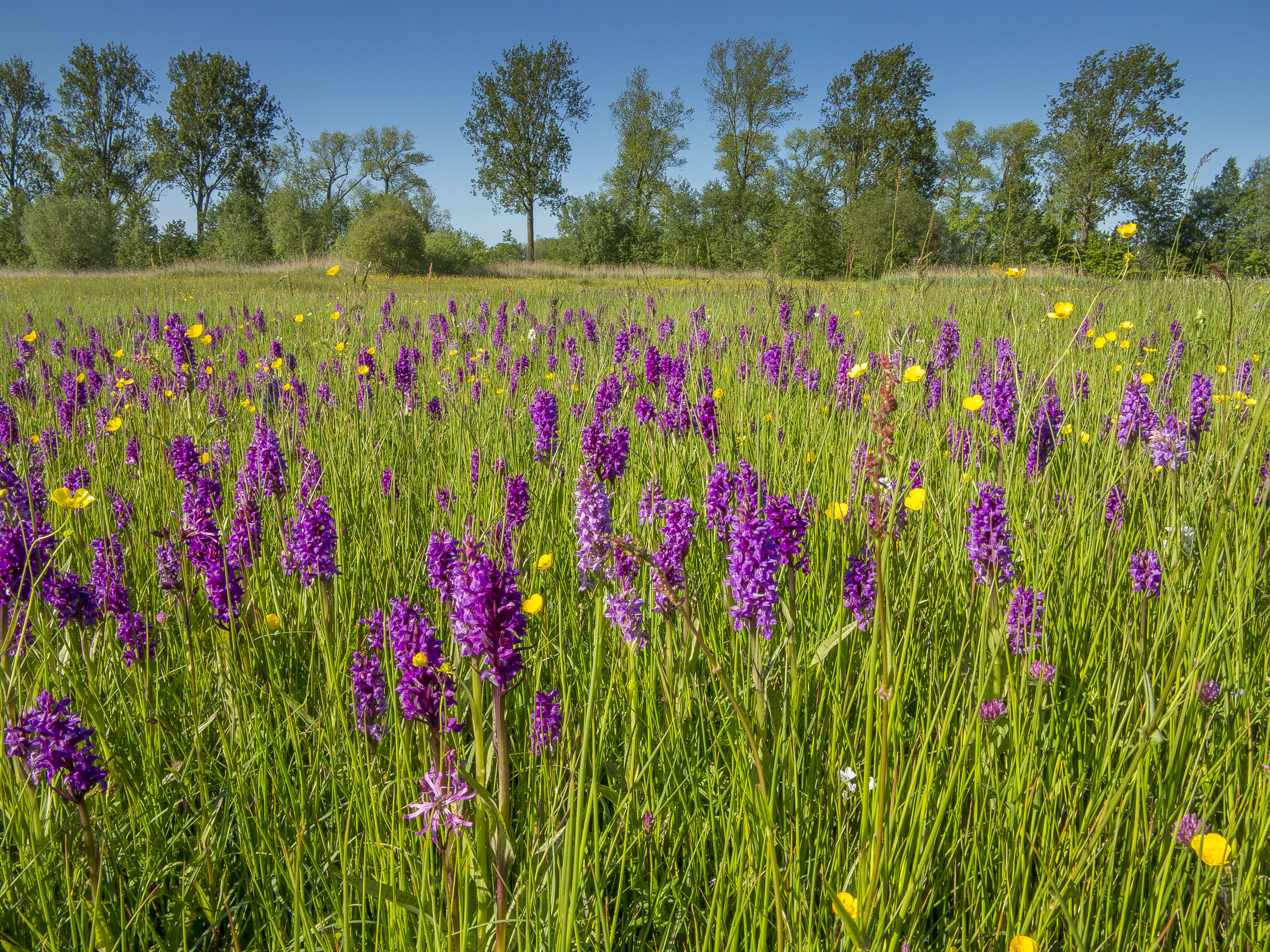
Fen meadow and transition mire nature reserve