
biological oxygen demand
Type of resources
Available actions
Topics
Keywords
Contact for the resource
Provided by
Years
Formats
Representation types
-
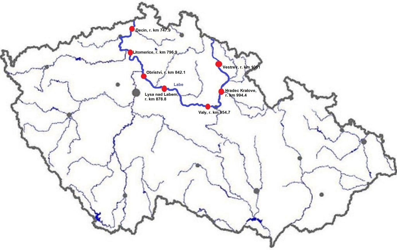
The Elbe River is one of the major rivers in Central Europe. It springs at an altitude of about 1,400 meters in the Giant Mountains in the north of the Czech Republic. It flows through eastern, middle, and northern Bohemia, and its catchment area includes most of Bohemia. The Elbe traverses the northeastern part of Germany and flows into the North Sea. The total river length is 1,094 km. In the Czech Republic, the monitored river length is 371 km and the catchment area includes 49,933 km2. The average flow at the Czech-German borders is 311 m3 s-1. Many weirs dam the watercourse of Elbe River in the Czech Republic. This artificial intervention is crucial for the characteristics of the riverbed, its width, depth, and bottom substrate. The width of the riverbed in the monitored area ranges from approx. 10 m on the upper course to approx. 150 m on the lower course and river sections above the weirs. The depth of the river varies from 0.5 m in the upper parts and below the weirs to more than 5 m in the lower course and above the weirs. The bottom substrate varies from the stony, gravelly, and sandy fractions in shallow and fast-running sections to muddy/silty fractions in slow-running sections above the weirs. The main tributaries of the Elbe in Bohemia are Metuje, Orlice, Jizera, Ploučnice, Vltava, Ohře and Bílina rivers. The catchment area is densely populated. The river is exposed to various sources of pollution (organic, agricultural, and industrial) and hydromorphological pressures (straightening, shortening, regulation of meanders, and fragmentation of river continuity). There are seven permanent monitoring sites on the Elbe River in the Czech Republic: Děčín (river kilometer 747.9), Litoměřice (796.9), Obříství (842.1), Lysá nad Labem (878.8), Valy (954.7), Hradec Králové (994.4) and Vestřev (1051). The Elbe basin long term environmental research has been organised by the Ministry of Environment of the Czech Republic and cooperation institutions since 1993. More than 600 physicochemical parameters, including sensory properties of water, are regularly monitored in at least nine different types of matrices (water, sediment, periphyton, floats, sedimentable floats, benthos, fish tissues, fish fry, and Dreissena polymorpha tissue) and using passive samplers. Among the main monitored characteristics belong balances of macroelements (carbon, nitrogen, oxygen, phosphorus), concentrations of inorganic salts, heavy metals and various organic pollutants such as pesticides, personal care products (including drugs) and other anthropogenic substances in the environment. Characteristics such as abundance and species composition are regularly monitored in fish, macrophytes, macrozoobenthos, phytobenthos and plankton.
-
Black Sea site includes three areas: cape Kaliakra, cape Galata and Varna Bay, and Koketrays Sand bank (only for macrozoobenthos). They were chosen on the base of historical data availability and eutrophication/pollution impact. Kaliakra marine area is influenced by eutrophication due to mainly the Danube river inflow. The local anthropogenic impact in the region is insignificant. It is a nature reserve. Cape Galata and Varna Bay sites are under the indirect impact of Varna Bay current and the system Beloslav lake-Varna lake - a cascade introducing nutrients and pollutants of industrial (chemical industry), agricultural, sewage origin and nearby ports. Koketrays Sand bank is an unique benthic habitat. The coordinates of the selected areas are as follow: c. Kaliakra: 28.416667 43.366667 c. Galata: 27.933889 43.186111 Varna Bay: 28.166667 43.166667 Koketrays bank: 27.888889 42.635556
-
The Morris Kahn Marine Research Station was established in order to provide baseline data and understanding of the marine ecological system in the Mediterranean Sea of Israeli coastal waters. The Charney School of Marine Sciences at the University of Haifa recently established a long-term ecological research station focusing on the eastern Mediterranean basin located in Kibbutz Sdot Yam, 44 km south of Haifa, near Caesarea. The station is called the Morris Kahn Marine Research Station and focuses on five main research topics; · Top Predators · Sediments · Water composition (Biogeochemistry) · Rocky Bottoms · Fish Disease (pathogens) The Israeli coastal area and the eastern Mediterranean Sea is experiencing accelerated development and infrastructure projects along the coastline, and a massive exploitation of marine resources never experienced in our region and nation. Coupled with the effects of global climate change and local polluting factors, life in the shallow and deep sea are changing rapidly. The Morris Kahn Marine Research Station is responsible for collecting biological and ecological data for long term research that will provide insight for understanding processes and predicting the effects of climate change and development on the environment. Such data will allow for science-based decisions that will greatly influence the interaction nature of future generations with the sea and the marine environment. This issue is particularly important given the fact that an majority of the water consumed in Israel is produced through desalinization of sea water, the main energy supply is based off of marine gas fields, aquaculture is gaining momentum as development allows for the cultivation of fish for human consumption in marine farms, and national projects referring to the sea as “developable land” that can be dried and made into artificial islands for various infrastructures. In order to accompany such a momentum in development without the collapse of the ecosystem and destruction of the sea as a natural resource, there is a need to provide reliable and in depth understanding as to how the system works. To accomplish these goals, the station employs top of the line researchers specializing in the Mediterranean as well as collaborate with other academic and research centres in Israel, while providing the best equipment for research and analysis of data collected from the sea including; · Rosetta collecting water samples from different depths · CTD device for measuring physical data of water · Advanced underwater photography and documentation equipment · Closed and controlled water system for aquaculture research · Device for detecting and quantifying nutrients in the water (Seal AA3). · Robot for measuring isotopes in samples (GC-IRMS-MS) · Confocal microscopy · Membrane mass spectrometer · Servers for database backup and maintenance · AAUS diving club performing scientific technical dives · Closed dive systems to allow deep, long, and safe dives · Boat used as a platform for diving and marine monitoring on the continental shelf · Laboratories for dissection · Work rooms for student and guest researchers · Meeting/conference rooms · AUV and ROV (Marine technologies lab) · THEMO buoy for deep sea research · Drones and other aerial devices · Website for sharing information as well as providing accessible information for the general public
-
The site comprises 4 km stretch of a complete alluvial floodplane managed as a private nature reserve some 10 kilometer upstream of the city of Leuven. Since 1990, human interference in the river channel has stopped resulting in a spontaneous meander evolution and roughening of the river channel. This has induced frequent (e.g. yearly) inundations, thus avoiding flood damage in the city of Leuven downstream and this without creating the usual storm basins.
-
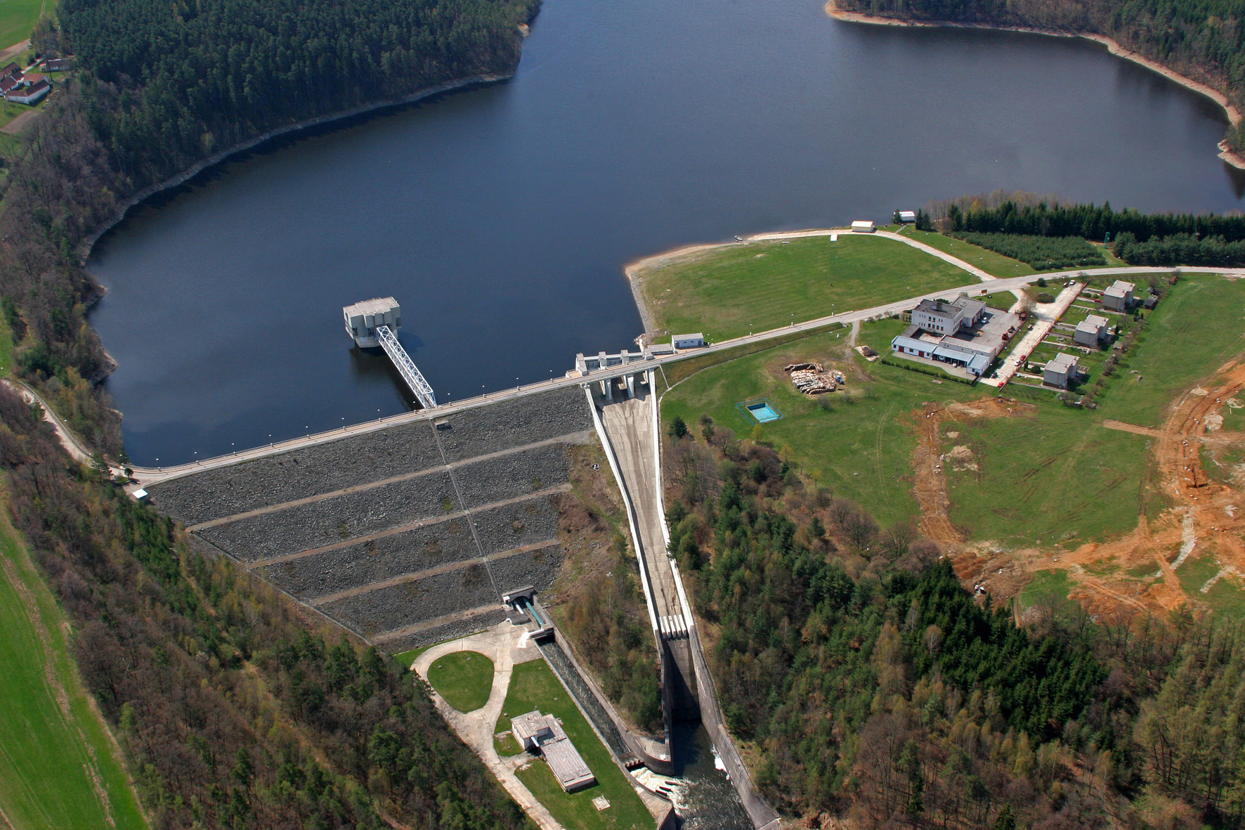
The Římov Reservoir was constructed in 1971–1978 at 21.85 km of the Malše River (tributary of the Vltava River), downstream its confluence with the Černá stream. The reservoir serves as an important drinking water supply for South Bohemia and helps to maintain a minimum flow downstream. The dam is 47 m high and 290 m long. Reservoir volume is 34.3×10⁶ m3, the catchment area is 489 km2.Mean annual flow is 4,3 m3 s-1 and mean theoretical water retention time 92 days. The Římov Reservoir is a canyon-shaped impoundment with steep banks, the „tower“ for drinking water input is at 5 m distance from the dam. Being a drinking water source, Římov Reservoir is protected and no other uses are allowed. Regular investigations of the Římov reservoir in its lacustrine part started in 1979 and have continued at three-week intrevals up to now. Since 1997, the Římov reservoir has been a part of the Czech LTER network. The parameters studied include physical, chemical and biological data on pelagic organisms like bacteria, protists, phytoplankton and zooplankton. Once per year, the abundance and species composition of fish is investigated. Besides regular monitoring, a lot of extensive studies were done of pelagic organisms, their diversity, interactions and functions as well as chemical processes in water and sediment, both in the lacustrine part and in the canyon-shaped riverine part near the inflow. Such intense studies were possible due to the vicinity of well equipped labs in České Budějovice and the construction of a field station at the dam (in 1994).
-
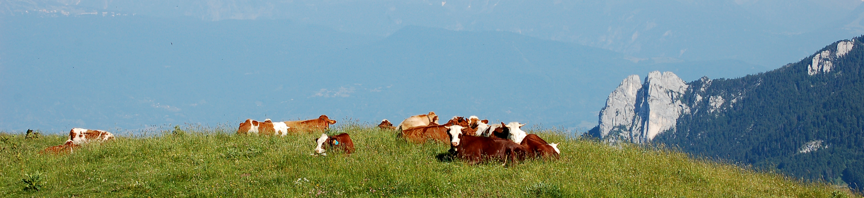
The LTSER Zone Atelier Alpes is a research platform that embraces all the French Alps as defined by the European Alpine Convention. The platform hosts several sites dedicated to the long term monitoring of social-ecological systems : one GLORIA site (FR-AME), a large set of permanent plots located along several elevational transects (ORCHAMP project), a network of sentinel alpine pastures, etc. Infrastructures regroups all facilities and observatories maintained by the academic community Univ. Grenoble Alpes. More intensive research investigations concern three master sites: (1) the 'Lautaret-Galibier' master site includes the Lautaret Garden, an alpine field station member of the Anaee network (2) the 'Arves-Mont Blanc' master site ranges from urbanized valleys to the highest summit of Europe (3) the 'alpine trench Grenoble-Chambéry-Annecy' master site is a large area encompassing the urbanized valleys of the western border of the French Alps (Grenoble-Chambéry-Annecy) and nearby mountain ranges (Vercors, Chartreuse, Belledonne & Bauges). The LTSER Zone Atelier Alpes belongs to LTER-France network and is located in south eastern France.
-
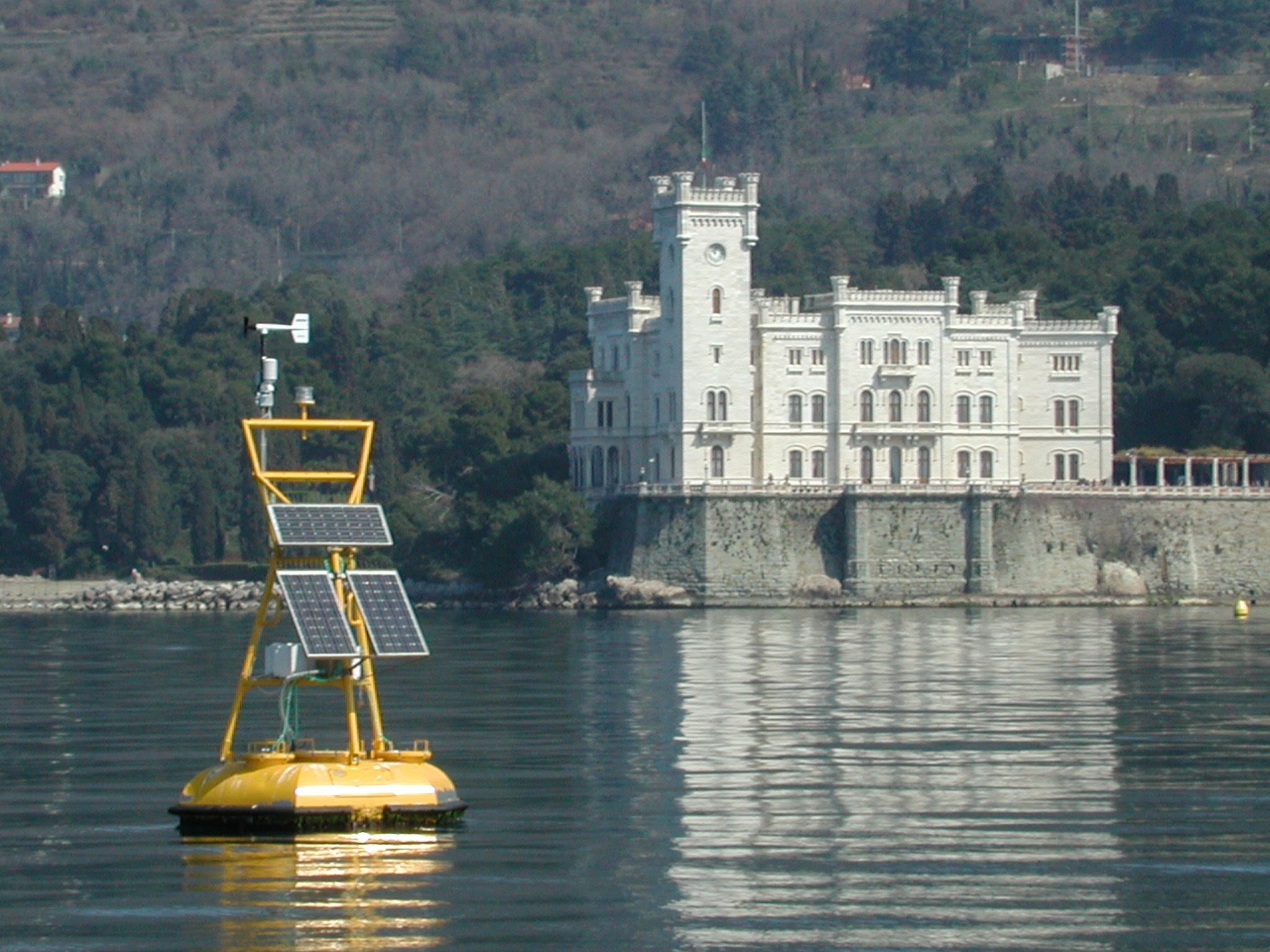
The coastal marine observatory site Gulf of Trieste lies within the Marine Protected Area (MPA) of Miramare and includes the biological time-series station “C1”, part of the Italian Long-Term Ecological Research (LTER) network, and the in situ continuous MAMBO meteo-oceanographic buoy. Marine Protected Areas represent one of the most effective systems for marine biodiversity preservation and management. Since 1986, the time-series station “C1” in the Gulf of Trieste (GoTTs, Gulf of Trieste Time series) represents a crucial site for marine ecological research, as it is subject to the interaction among several natural forcing (river, groundwater discharge, tides, general circulation, intense meteorological) and numerous anthropogenic activities (maritime transport, harbours of Trieste and Monfalcone, urban waste discharge, mussel- and fish-farming, fishing and recreational activities). In 1999, the ecological research site has been equipped with a meteo oceanographic buoy (MAMBO) in order to acquire continuous data on meteorological conditions at sea and on seawater physical and biogeochemical properties. Due to the high temporal dynamics of ecological processes in coastal ecosystems, continuous and real-time data of the main meteorological, physical and biogeochemical properties are fundamental for a better understanding of marine ecosystem functioning.
-

The Seine estuary is a megatidal estuary located in northern France. It is the third largest estuarine ecosystem in the country after the Gironde and Loire along the French Atlantic coast; its waters flow into the English Channel. The geographical zone of influence of the Seine estuary runs from just upstream of the Poses dam, at the limit of the tidal penetration into the estuary — 160 km upstream of Le Havre —to the eastern part of the Bay of Seine. It can be divided into three sections: the fresh water upstream section (125 km), the mixing zone characterized by varying salinity levels (35 km), and the marine downstream section under the influence of the Seine River. The megatidal regime generates a turbidity maximum in the mixing zone (middle estuary) between the marine and fluvial sections of the estuary. The Seine estuary is a typical estuarine ecosystem: highly stressed by natural fluctuations and anthropogenic pressures, and hosting a rich ecological system. The Seine valley and its estuary are of major economic importance for France, with the presence of two maritime ports. It’s watershed (79,000 km2) is the home to 17 million people, and accounts for 50 % of the river traffic in France, 40 % of the country's economic activity, and 30 % of its agricultural activities. In addition to the Greater Paris area (> 11 million inhabitants), which contributes heavily to the Seine estuary's upstream inputs, two other major river settlements — Rouen (500,000 inhabitants) and Le Havre (300,000 inhabitants) — are maritime ports of international importance. Due to economic development, the Seine estuary has been subjected to major hydrodynamic, ecological, biogeomorphological and biogeochemical changes. The importance of studying the effects of anthropogenic impacts on estuarine ecosystems has increased in the last decade, especially under the Water Framework Directive, which aims to achieve “good environmental status” of all European water bodies.
-

Historically, the role of the Galapagos Islands has been considered critical due to the evolutionary diversification induced by natural and historical isolation. The Galapagos National Park was established in 1959, based on its historical importance associated with Charles Darwin's voyage and its rare and endemic biodiversity, composed of unique vertebrate and plant communities (Rozzi et al. 2010). In 1978, the Galapagos Islands were declared a UNESCO World Heritage Site, a critical factor associated with this national park (Rozzi et al. 2010). The Galapagos Islands are a pristine area with local and regional climates influenced by the interaction of ocean currents and winds driven by the Inter-Tropical Convergence Zone; ITCZ (Conroy et al. 2008, Trueman and d'Ozouville 2010). The long-term programme includes forty natural aquatic ecosystems (lakes, ponds, lagoons and swamps) that will be sampled on the islands of San Cristobal, Santa Cruz, Isabela and Floreana, where possible along a lowland-highland gradient. The number of sampling points will vary according to environmental heterogeneity and the presence of a littoral region, among other factors.