
biological parameter
Type of resources
Available actions
Topics
Keywords
Contact for the resource
Provided by
Years
Formats
Representation types
-
Gis layers with the management points over the national park from 2010 - 2015
-
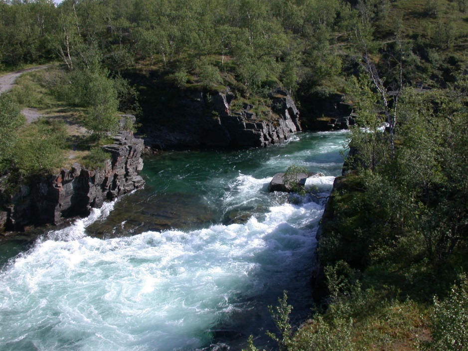
This protected area is located at the ecotones between the boreal forest and the subarctic tundra. The park was established as early as in 1909. In this year, the first nature conservation law in Sweden was created. The mountainous park has a surface of 77 km2 and covers an altitudinal gradient between 341 and 1191 m asl. The limits of the park are defined by mountain ranges and by the Tornetraesk lake. Since 2007, the Natura 2000 site Nissuntjårro is connected to Abisko National Park in the Southeast. This reserve covers additional 250 km2. The Park and the Natura 2000 sites at Abisko are close to the larger “Laponian Area” which is protected since 1996 as World Heritage by the UNESCO. The landscape and ecosystems in the area are mainly driven by natural ecological processes such as permafrost. The topography is reflecting the glacial history. Most famous example is the U-shaped glacial valley Lapporten close to Abisko. The famous Abiskokanjon, a natural canyon that discharges into the Tornetraesk Lake, is the habitat of rare birds and it was a major cause for installing the national park. The vegetation is dominated by birch forest and dwarf shrub vegetation. It is rich in bryophytes and lichens. Here, at the oceanic margin of the boreal zone, deciduous trees (Betula pubescens ssp. czerepanovi) are replacing the dominance of conifers. Depressions in lowlands are typically covered by mires and bogs. Above the tree line and especially at the mountain Noulja och Slåttatjåkka outstanding species diversity is recorded, for such a northern ecosystem. This is one of the most species-rich places in the Scandes even hosting endemic species, which is quire rare up north. The fauna in the park is characterised by reindeer and moose. Small herbivores such as lemmings are frequent, too. Main predators are golden eagles, brown bears, polar fox, lynx and wolverine. The location of the Abisko National Park at the ecotones between two major biomes (boreal forest and tundra) in combination with the strong impact of permafrost makes this landscape very sensitive to climatic changes. One important biotic interaction is the regular outbreak of moth populations (approx. every 10 years) causing total defoliation and even above-ground die-off of birch at the landscape scale. Such gradations may increase in the future as a consequence of less frost control on the insect populations. If thresholds / tipping points would be surpassed, such warming effects could cause as a paradox the southward shift of the tree line and further negative implications for carbon pools and ecosystem services. On the other side an upward and north-ward expansion of birch is also recorded. The future trends of ecosystem development are unclear and protected areas will serve as a natural laboratory to investigate ongoing changes that are relevant for the whole subarctic biome. The fact that Abisko is the place of one of the most active and well-known ecological research stations. The whole region is sparsely settled by man. Local Saami (or Lapp people) population’s economy is traditionally based on reindeer herding. Abisko National Park is located in the centre of the largest area in the world with an ancestral way of life based on the seasonal movement of livestock. Only few cities exist in the far north so that light pollution is low. This favours the observation of the frequent auroras in this place, 195 km north of the Arctic Circle. Abisko National Park is of eminent importance for tourism in this peripheral region. The most famous Swedish hiking trail, the Kungsleden, starts at “Abisko Turiststation”. The major ecosystem services of the park are related to the aesthetic value of the landscape with picturesque lakes, waterfalls and mountains. Tourism is an important economic factor. The pastoral land use based on reindeer by the local Saami people is a traditional and still important factor as well. Finally, the contribution of the subarctic ecosystems to carbon sequestration must be mentioned. The Abisko Scientific Research Station (ANS), managed by the Swedish Polar Research Secretariat, is one of the most important boreal and arctic ecological research sites. Here, researchers from many countries unite. Long-term data sets have been recorded and also EO approaches have been implemented (Jonasson et al. 2012). The first station dates back to 1903! Jonasson, C.; Sonesson, M.; Christensen, T. R.; Callaghan, T. V. (2012). Environmental Monitoring and Research in the Abisko Area—An Overview. AMBIO 41: 178–186
-
3M_RECITAL - MINHO, MONDEGO, AND MIRA ESTUARIES observatory: Long term vaRiation of ECOLOGICAL sTAtus as a response to naturaL and human induced changes. Implications for management and restoration. Mondego estuary site: The Mondego River drains a basin of approximately 6670 Km2 and its valley is considerably steep in upstream sections, forming a large alluvial plain consisting of good agricultural land in downstream areas. Since the 1960s, the Mondego catchment area underwent a large scale morphological modification, involving the construction of stone walls, to regulate the river water flow and enlarge harbor facilities, and water reservoirs to control floods, improve the uses of water resources, and produce electric power, which modified the riverbed topography and changed the system hydrodynamics. The river contributes presently with a high anthropogenic loading of nutrients and several chemicals into its relatively small estuary (1600 ha, splitting in two arms separated by an island in the terminal part), causing eutrophication. Besides, the estuary - Western coast of Portugal - North Atlantic Ocean Eco-region - supports industrial activities, salt-works, and aquaculture farms, and is the location of Figueira da Foz, a harbour and a centre of seasonal touristic activity. A comprehensive study on the Mondego estuary environmental quality has been carried out during the last two decades, focusing on water quality, hydraulics and sediments dynamics, plankton communities (phyto, zoo, and ichtyoplankton), the term evolution of the benthic communities (intertidal and subtidal), and the changes in macrophytes’ beds (Zostera noltei) and green macroalgae distribution in relation to morphological alterations.
-
not ready
-
t.b.d.
-
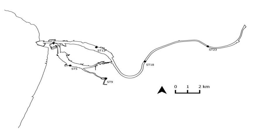
Grimsö wildlife research area (GWRA), SLU, is located in south-central Sweden at the end of the Nordic taiga, in the hemi-boreal zone. GWRA comprise 130 km2, covered mainly by mixed coniferous forest (74%), bogs and mires 18%. About 85% of the area is managed by conventional forest practices, and the area also includes two forest reserves of ca 4 and 11 km2. Farmland constitutes 3%, and lakes and rivers 5% of the area. The landscape is relatively flat, with altitudes ranging from 75 m.a.s.l. in the south to 180 m.a.s.l. in the north. The area hosts the expected mid-Swedish flora and fauna. Wildlife research started at Grimsö in 1974 and the activities has expanded over time and include at present an established staff of ca 40 people.
-
Analysis of a set of water samples were taken from several sites in the Jamtal in July and September 2021. Water pH, electrical conductivity, alkalinity, major ions (Ca, Mg, K, Na, SO4, Cl HCO3), and major nutrients (NO3-N, NH4N, total N, PO4, total P, SiO2) were analyzed. At the same time samples for the analysis of epilithic and epiphytica diatoms, used as bioindicators of the overall ecological quality of the streams and springs were collected.
-
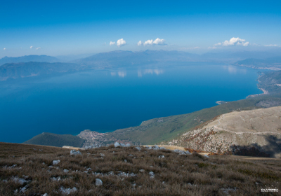
The Region of Ohrid and the Prespa Lakes, situated in south-western Europe (40°40’- 41°2'N latitude; 20°23’-21°16’E longitude), extends across the borders of Albania, Greece, and Macedonia. Lake Ohrid and Prespa Lakes belong to a group of Dasseretes basins that originated from a geotectonic depression 2 to 5 million years ago on the western Dinarides. Because of the karstic underground a large amount of water of Prespa Lakes seeps into the soil, drains away trough a network of underground fissures, and supplies the springs located on the shore of Lake Ohrid. Lake Prespa is therefore considered to be a part of the Lake Ohrid Watershed. The total area of the Lake Ohrid Watershed amounts 3,921 km² of which 1,402 km² belong to the Lake Ohrid sub-watershed and 2,519 km² to the Prespa Lakes sub-watershed. Lake Ohrid (41°2'19" N, 20°44'13" E) is the oldest lake in Europe. The lake is situated in the Ohrid valley, in the south-western part of Macedonia, bordering Albania, at an altitude of 693.17 m a.s.l. Approximately two thirds of the lake surface area belong to Macedonia and the remaining third to Albania. It has a surface area of 358.2 km2, a maximum depth of 288.7 m, a mean depth of 163.71 m, a water volume of 58.6 km3, and a shoreline length of 87.53 km. The drainage area is 1129 km2, with 40 tributaries. Evaporation (40%) and the main outflow, the river Crn Drim (60%) balance the water budget in Lake Ohrid. The hydraulic residence time in Lake Ohrid is about 70 years. Lake Prespa (40°54' N, 21°02' E) is a transboundary lake shared between Macedonia, Albania and Greece. The lake is located at 849 m above sea level has a surface area of 254 km2, a catchment area of 1300 km2, a maximum water depth of 48 m, a mean water depth of 14 m, and a volume of 3.6 km3. The total inflow is estimated to 16.9 m3/s, with 56% originating from river runoff from numerous small streams, 35% from direct precipitation, and 9% from Lake Mikri Prespa to the south. There is no surface outlet of Lake Prespa. Water loss derives through evaporation (52%), irrigation (2%) and outflow through karst aquifers (46%). The ecological importance of both lakes has been acknowledged by the declaration of Lake Ohrid as UNESCO world heritage site in 1980 and the establishment of the Prespa National Park in 2000. The high diversity of avifauna especially among the migratory birds, has enabled Lake Prespa to be designated as Ramsar site in 1999. Due to all its peculiarity, natural uniqueness and ecopotential, in 2014, the area of both, Lake Ohrid and Lake Prespa have been proclaimed as Transboundary Biosphere Reserve. Lake Ohrid is a unique aquatic ecosystem and a hotspot of freshwater biodiversity with more than 210 endemic species described. Due to the long history of Lake Ohrid’s continuous existence and the geographical isolation and permanency of life conditions in the lake, a relatively high number of lake organisms are still speciating. Species, by emphasizing the benthic fauna representatives, continue to diversify into new taxonomic categories - subspecies, species and even families. This type of speciation, also known as intralacustrine speciation, is typical in old, deep and large preglacial lakes, such as Lake Baikal. Taking surface area into account, Lake Ohrid is even considered to be one of the most diverse ancient lakes in the world with regard to the number of endemic species: Bacillariophyta 14%, endoparastic Infusoria 88%, Rhabdocoela 44%, Tricladida 71%, Hirudinea 54%, Gastropoda 90%, Amphipoda 90% and Ostracoda 66%. Lake Ohrid represents a refuge for numerous freshwater organisms from the Tertiary Period, whose close relatives can be found only as fossil remains; this is the reason the lake is sometimes called a "museum of living fossils". Among them are included the famous Ohrid Trout (Salmo letnica) and a freshwater sponge (Ochridospongia rotunda). Due to its peculiarities, Lake Ohrid is considered to be a key site for biodiversity and speciation research. There is high habitat diversity in the Prespa basin, with a flora of more than 1300 species. From a phytocoenological perspective, the presence of the endemic plant community Lemneto-Spirodeletum polyrrhize aldrovandetosum is the most important. Lakes Prespa is one of two proclaimed Ramsar Sites in Macedonia, noted as significant bird migration and breeding habitats, as well as for their biodiversity. In total, there are 23 freshwater fish species (80% of which are endemic); 11 amphibian species; 21 reptile species; more than 42 mammal species, among which are endangered brown bear, the wolf, the otter and the chamois; and over 260 species of bird. As well as providing a shelter for over 90 species of migratory birds, the Prespa lakes are also home to tens of species that have been officially registered as critically endangered or vulnerable. Among these is the Dalmatian Pelican, one of the largest flying birds in the world. Seventeen of Macedonia’s 20 endemic fish species are included within the category of globally threatened species: seven are restricted to Ohrid Lake and six to Prespa Lake.
-
Lake Biwa is the largest lake in Japan. The maximum depth is 104 m, and the volume of water storage is 27.5 km3.
-
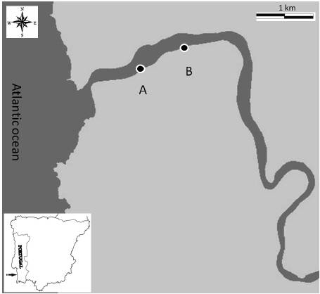
The Mira estuary is a small system (2 km2) located at the Southwestern coast of Portugal that extends between Vila Nova de Milfontes at the mouth and Odemira at its upper limit. It is a narrow entrenched system, with a length of more than 40 km and a mean depth of about 6 m. Saline variability is higher in the middle estuary and sediments are usually dominated by mud and/or fine sand, except in both ends of the system where coarse sediment particles predominate. Near the river mouth presents ecologically important seagrass beds of Zostera marina and Zostera noltii in the subtidal and intertidal areas, respectively. Given the knowledge already available for fishes, benthic macroinvertebrates and saltmarshes communities in the Mira estuary, these are the biologic groups that will be studied with more detail in order to monitor their evolution and assess the hypothetic influence of climatic change and human activities in such evolution. In addition, zooplankton studies will be performed to investigate the impact of the hydromedusae exotic invader Blackfordia virginica in the different compartments of the Mira estuary ecosystem. It is usually considered a well preserved system due to reduced human population and industry. It has high conservation status because the entire estuary is included in a nature protected area (Parque Natural do Sudoeste Alentejano e Costa Vicentina) limiting fishing activities that currently are not allowed. The major threat to this ecosystem is the increasing touristic pressure in all the southwestern coast of Portugal, which may have serious implications to the estuarine water quality. Moreover, several fish farms were installed and agriculture (mainly rice fields) and forestry activities (mainly eucalyptus plantations) occupy an important extension of the water margins. The upstream estuarine areas show a slight contamination by heavy metals due to previous mineral extraction activities in the river basin. Several studies have been conducted in the estuary since the 1980’s. Little information is available for phytoplankton and macroalgae but data about saltmarshes and seagrass beds are much more abundant. Zooplankton data is also scarce but has increased in recent years, particularly with studies on the exotic invasive species Blackfordia virginica. Meiofauna was only studied in Zostera beds but benthic macroinvertebrates and fishes have been studied in more detail along the entire estuarine gradient. Nevertheless, investigation of modifications in these communities related with climate change, human activities and introduction of exotic species must proceed.