
birds presence
Type of resources
Available actions
Topics
Keywords
Contact for the resource
Provided by
Years
Formats
Representation types
-
Database built by volunteers from the Portuguese Society for the Study of Birds. Each row is a validated record of an observed species. The information on the number of individuals of that species is not reliable.
-
PELD-TMSG: Cerrado ecosystems in the region of the Triângulo Mineiro and Southeast of Goiás - Brazil
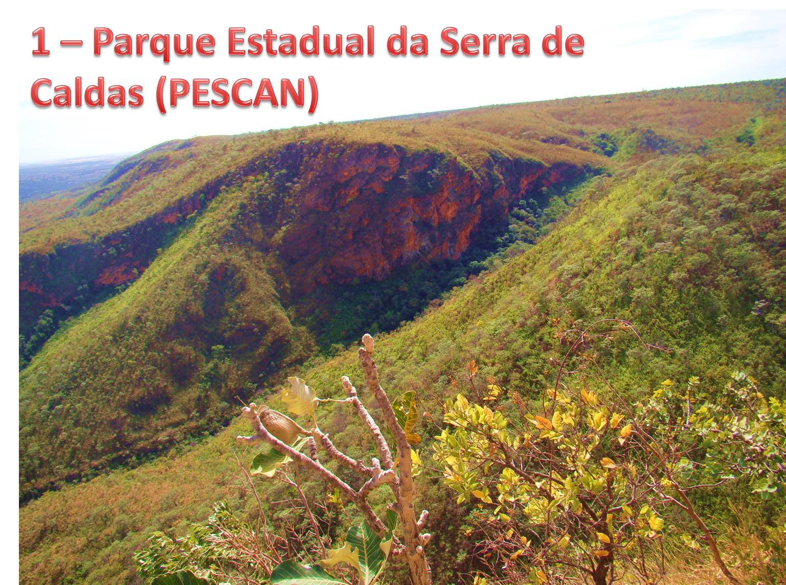
The site consists of 13 Cerrado fragments formed by five conservation areas and 8 remants of semideciduous forests. All these areas are within the basin of the Rio Paranaiba and thus share similar ecological conditions. These areas have similar human interference processes with already traditional agricultural use, impacts of hydroelectric facilities and recent intensification of the urbanization process.
-
The PELD FORR site is compound by five locations represented by two protected areas (Viruá National Park, hereafter, PNV, and Maracá Ecological Station, hereafter EEM), which are part of the Program for Research in Biodiversity (PPBio / MCTI), and three private forest areas. The selected protected areas are important for the conservation of several tree species (such as Centrolobium paraense), medium and large mammals, and several species of birds of conservation concern. Each of the protected areas selected as our study sites has a network of 30 permanent plots of 1 hectare, which are systematically distributed over an area of ~25 km2, and where ~20,000 trees are marked, mapped, and being monitored at intervals of five years since 2006. The forest areas outside protected areas surround PNV and are Brazil nut stands (Berthollethia excelsa) where rural population collect nuts for own consume or to sell. Working with the surrounding community is vital in proposing alternatives that combine economic return with forest conservation and the diffusion of sustainable agricultural practices is very important to hold the advance of deforestation and the threat of fire within the park boundaries. Being located at the northern edge of the Amazon, the PELD FORR site presents climatic and geological characteristics unique in the Amazonian scenario. Rainfall patterns, for example, are very different from other Amazonian active LTER sites, with a much longer dry season and a precipitation gradient that ranges between 1700-2300 mm/year. In addition, the selected areas represent forest ecosystems that are rare elsewehere in the Amazon and represent two important ecotones (white-sand / humid forest, and savanna / seasonal forest), which are sensitive to droughts, which should become increasingly frequent in the Amazon in predicted future climate scenarios. Extreme climatic events, like El Niño have affected Roraiman forest dramatically in previous years (e.g, 1997-98, 2010 and 2015-16), resulting in wild fires of great proportions. The Viruá National Park (PNV) has a total area of 214,950.52 hectares and was created in 1998 to protect samples of the ecosystems of the south-central region of Roraima, where the Campinaranas predominate, a term that designates a phytophysiognomy that occurs in areas of sandy and often hydromorphic soils. In the regional context, the Park is part of the Campinaranas Ecological Region, which extends through the Negro, Branco and Orinoco river basins, covering areas of the Brazilian, Colombian and Venezuelan Amazon. Recently the park received the title of a Ramsar site, showing its importance as a wetland area. PNV is marked by high environmental heterogeneity, with a great variety of physiognomies associated to topography, hydrology and soils. The predominant vegetation is the ecotone campinarana (white-sand forest) with extensive alluvial forest areas (floodplain and igapó forests) and mainland forest enclaves that include Open Lowland Ombrophilous Forests, as well as small enclaves of Open Ombrophylous Submontane Forests on isolated residual hills. PNV presents high floristic diversity, with 1262 registered plant species, including 1149 angiosperms and 110 pteridophytes (ICMBio, 2014). The soil types that predominate in the PNV are sandy, nutrient poor, poorly drained and developed over extensive sedimentary plains (Hydromorphic Quartzic Neosols and Hydromorphic Humic Spodosols). The low altitude of the land (between 45 and 60m) causes periodic flooding due to elevation of the water table or the accumulation of rainwater, whose flow is hampered by the presence in depth of layers cemented by iron oxides, aluminum oxides and organic matter (Mendonça et al., 2014). The low water storage capacity of these soils causes extreme water deficits during dry seasson. Parna Viruá is in a climatic transition zone (Aw-Am by the Köppen classification system) with the dry period peak between January-March and the rainy season between May-August (Schaefer et al., 2008). The Maracá Ecological Station (EEM) is a river island, about 830 km2 (60 km long x 25 km wide), located on the river Uraricoera, one of the main tributaries of Rio Branco, the main river of Roraima. Most of the island (90%) is covered by forests, although in the southern and eastern portions savannah patches are found. The forest phytophysiognomies present on the island include Ombrophilous Forest and Seasonal Forest. The height of the canopy varies from 25 to 40m, with occasional emergent trees reaching 50m in height. The diversity of tree species is low, compared to other areas of the Amazon (~ 80 species with dap ≥10 cm in 1.5 hectares), with occurrences of monodominant forest patches of Peltogyne gracilipes (Milliken & Ratter, 1998). Esec Maracá is home to populations of endangered tree species such as Albizia glabripetala (CNCFlora, 2016a) and Centrolobium paraense (CNCFlora, 2016b). Podzolic soils, mostly dystrophic and containing low base saturation, predominate on the island (Nortclif & Robison, 1991). In areas where the soil has low depth of root penetration, temporary flooding on the surface, and a high Mg: Ca ratio, monodominant forest patches are observed. Esec Maracá is located in the area described for the "Aw" climate (tropical climate with dry winter season). In the period from 1986 to 2004, the average annual rainfall registered was 2091 mm (ICMBio / RR). In general, the wettest month is July and the driest month, February (Nascimento, 1997). For the same period, from April to September (rainy season), the average rainfall was 1635 mm, and in the months of October to March (dry season), the average was 456 mm. Brazil nut stands: The permanent plots located in forests with natural occurrence of Brazil nut (Bertholletia excelsa) were established by Embrapa Roraima between 2005 and 2008, with the objective of studying population dynamics (growth, mortality and recruitment) and fruit production and seeds in natural populations of the species. Each plot has a total area of nine hectares (300 x 300 m), subdivided into 144 subplots of 25 x 25 m, in which all Brazil nut trees with DBH (diameter at 1,30 m from the soil) equal to or greater than 10 cm were marked, mapped and measured (stem and crown diameter and total height). All plots have been monitored annually since its establishment (2005-2008). In total, there are five plots, one of which is in the municipality of São João da Baliza, 313 km from the capital Boa Vista, and four in the municipality of Caracaraí, 135 km from the capital. The plot located in São João da Baliza was installed in 2006 and has 34 marked individuals (average density of 3.8 Brazil nut trees/hectare). The region is characterized by Dense Ombrophylous Forest vegetation and the climate is Awi type (tropical humid with small dry season during the year), with a dry period between November and March (Barbosa, 1997). The plots installed in the municipality of Caracaraí are located around the Viruá National Park. Two plots were installed between 2006 and 2007 in a 400 ha forest fragment where the average density of Brazil nut trees was estimated as 13.2 trees/hectare, totalizing 238 individuals. Other two plots were installed in 2008 in an area with density of 6.3 trees/hectare, totalizing 113 individuals. The vegetation in the region was classified as Open Tropical Rainforest with Palms and the climate of the region as Ami (rainy tropical, with small dry season), with average annual precipitation between 1700-2000 mm, being the rainy period between April and August.
-
Data on bird presence and abundance in Doñana is available since the 50ties, even before its protection. EBD-CSIC started standardized monitoring by aerial counts in the 70ties, initially focused on wintering birds but since de early 80ties counts are conducted monthly, and up to 50 bird species are identified in 52 counting areas within the marshes. Terrestrial bird count of main bird concentrations of Doñana have been conducted at the same time (both EBD-CSIC and Park Management) but were not standardized until 2002 by EBD-CSIC. Since then, monthly surveys have been conducted covering about 87 water bodies of the marshes and from fixed observation points (up to 196 water bird species are included). Additionally, each month, a transect (30 km) count of birds (all non-passerine species and Corvus corax) present at the beach and sea shore is done by car. Furthermore, during spring, colonial water bird nests are located and chicks ringed when possible. Several colonies have been monitored since the 80ties. Non-colonial waterbird nests are located monthly during the breeding season using linear transects on horse in the marshes, totalling about 65 km. These transects data are being collected since 2003. Earlier data on non-colonial breeding waterbirds are more disperse, although ringing activities have been done since the 70ties on regular bases.
-
Regular monitoring activities of the Park's fauna has so far comprised 3 bird species: the golden eagle, peregrine falcon and capercaillie, and 3 mammal species: the Tatra marmot, the chamois, and the brown bear. GIS data layers collected on marmot colonies, preferred areas of occurrence of the chamois (and its range above tree line), as well as roaming areas and occurrence of brown bears (as well as of bear-human conflict hotspots). For birds, spottings, areas of occurrence, number of nesting individuals were monitored. This monitoring will be continued and expanded (to include more species of Community Importance) in a new, currently implemented Park monitoring regime under the new Park Protection Plan (to enter into force soon, as of August 2016).
-
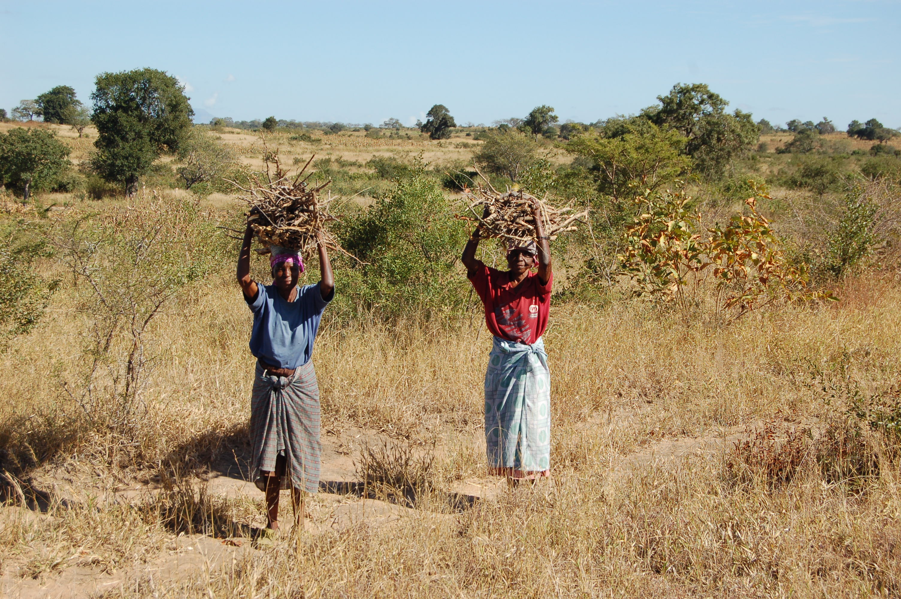
A developing long-term research site, designed to determine the effects of harvesting of natural resources (particularly fuelwood) and domestic livestock on the biodiversity and ecosystem functioning of a savanna ecosystem.
-
PLANNED (as of August 2016) regular monitoring activities of the Park's Natura 2000 habitats are specified in the new Park Protection Plan (currently in the final project stage, pending final approval and implementation resolution by the Minister of Environment). They'll altogether comprise 19 bird species, 8 mammal species (incl. 2 sp. of bats, wolf, brown bear, lynx, Tatra marmot, chamois), 2 amphibian species and 2 invertebrate species (beetles). Methodology-wise, depending on the species, they'll be conducted as 1 to several monitoring rounds/inspections performed annually or at several-year intervals, in most cases in a season-dependent manner, and will involve various, species-specific methods (field observations, tracking, transect counts, site inspection, counting/inventory of nests, colonies or dens/burrows, analysis of habitat area or condition, genetic sampling, etc. etc.). For the purpose of the Park's Protection Plan, nature inventory and assessment of the current state of conservation of the above-mentioned species was conducted and indicated by FV or U1 (no U2s or XXs, luckily) with respect to 3 parameters: population, habitat, future prospect - plus the cumulative value. The data may be available at the Park.
-
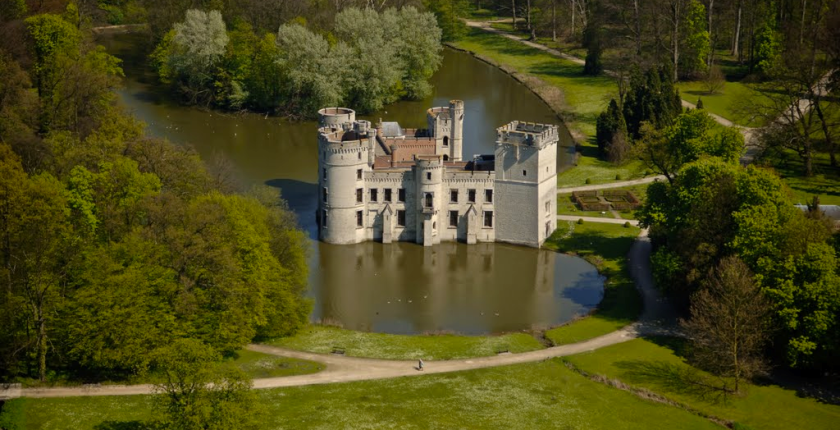
The site of Botanic Garden Meise is a 92 ha domain near Brussels. It has been assembled from parts of two historic castle parks. For more than 75 years it has been home to a collection of plants, as well as a research institute dedicated to botany, forming one of the largest botanic gardens in Europe but also an important tourist attraction close to Brussels. Some habitats get a high degree of disturbance, either due to garden maintenance, or from the large number of visitors. There are also managed and more natural areas. A variety of terrestrial and aquatic habitats occur, among which valuable woody (semi-)natural areas, and also managed meadows. The study of biodiversity in the park has relealed an exceptional species richness in many taxonomic groups. More than 600 wild vascular plant species have been found since 2002, including rare species that were inadvertently introduced during the 19th century, so called wood lawn neophytes . Since 1993 the ectomycorrhizal fungi have been monitored, and there are observations of 52 Red List species in the domain. The park is also the richest Belgian site for Laboulbeniales (Ascomycetes), obligate ectoparasites of Arthropoda. Especially the wet ash-alder forests hold a number of rare and unique taxa and host-parasite combinations, some of them with only a few localities known worldwide. Moreover, the domain is a biodiversity hotspot for lichens and lichenicolous fungi, among other factors as a result of management, such as the regular maintenance of the undergrowth which has a positive effect on light-loving epiphytic lichens, and also due to the diversity of habitats and the large range of different substrates of varying age and of ecological conditions. Another well represented group are diatoms (Bacillariophyta), of which a mere survey in a small pond already yielded two species which have been described as new to science. The site is also rich in fauna, for example rare bat species that overwinter in our historical underground ice cellars. The diverse range of cultivated species also attracts an enormous range of arthropods and plant pathogens, which we know exceeds what we know of it.
-
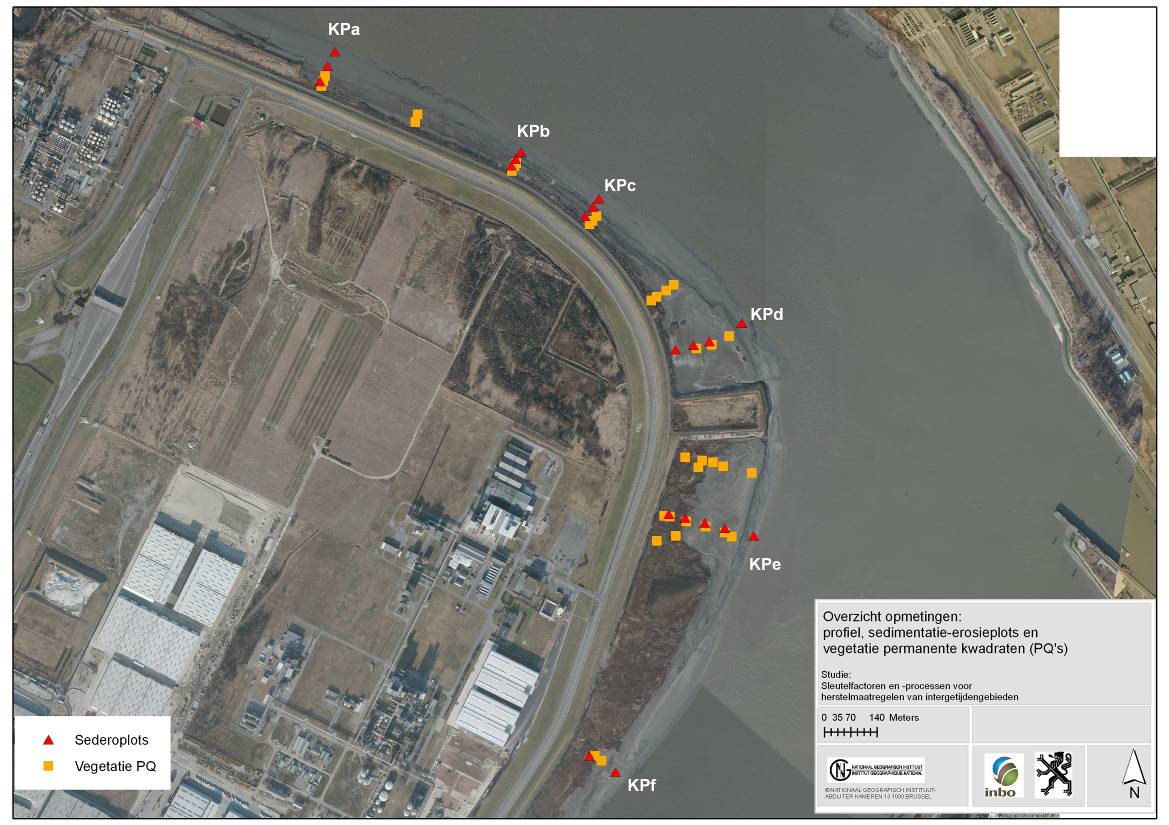
The site is a managed realignement (Sea Wall Removal) combined with a land lowering to start estuarine development in a suitable tidal frame. The site was created in 2002 and monitored in an initial phase intensively. (aspects of morphology, sediment characteristics (including polluents), macrozoobenthos, vegetation and birds). Vegetation and birds are ongoing monitoring.
-
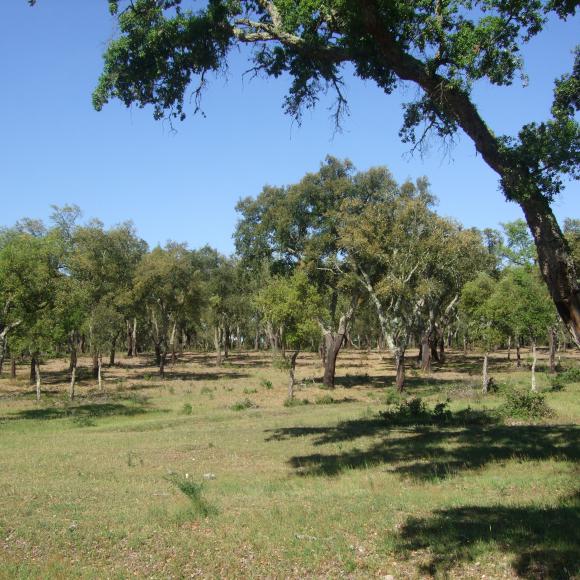
Machuqueira do Grou is one of the six research and monitoring stations of LTER-Montado, an umbrella site located in the Alentejo province in south Portugal (southwestern Iberia). The "Montado" represents an unique agro-silvo-pastoral ecosystem (named "dehesa" in Spain) found only in the Mediterranean basin. These savannah-like landscapes are dominated by evergreen cork and/or holm oaks and were shaped over millennia of traditional land use practices. These multi-use forests are two-layered systems that combine, in a single space, forest harvesting, extensive livestock husbandry, pastures and/or cereal cultivation (the most evident economical revenues), with other traditional uses (hunting, beekeeping and mushroom picking). Recently, increasing awareness arose on their benefits as biodiversity reservoirs, recreation grounds, and other ecosystem services providers, but these non-productive functions are not equally perceived and valued by users, as they tend to be conflicting with productive ones. Machuqueira do Grou is a state-run property, located Bank tributary of the Tagus River, in the Ribatejo province, 100 km northeast Lisbon and 25 km from Coruche (39.116° N – 8.352°W). Cork oak (Quercus suber) is the dominant tree type, with an average of 90 adult trees per hectare. Managed as an agro-silvo-pastoral system but most of the woodland has been managed so as to maintain or increase tree crown cover over the last 10 years. Some tree decline is observed, especially on podzols. The natural regeneration of the tree stand is not uniform, and they are lacking in some places because of grazing and shrub clearing for fire prevention. No fires have been reported in the last 100 years. Conflicting interests arise from the livestock grazing component that affects the natural regeneration of cork oak trees. Interventions and adjustments to promote natural regeneration and active afforestation (e.g. fencing combined with shrub clearing) have been included in the stakeholder´s management plan over the last 5 years.