
breeding success
Type of resources
Available actions
Topics
Keywords
Contact for the resource
Provided by
Years
Formats
Representation types
-
The monitoring of bird populations focused on wetland species. It included breeding bird surveys and bird migration (bird ringing) of species most common in the reed belt of Lake Neusiedl, and meadows surrounding the soda pans. Bird surveys of Biological Station Lake Neusiedl refer mainly to the INTERREG Project of “Vogelwarte 2” and were in close collaboration with the National Park “Neusiedlersee – Seewinkel” and “BirdLife Österreich”.
-
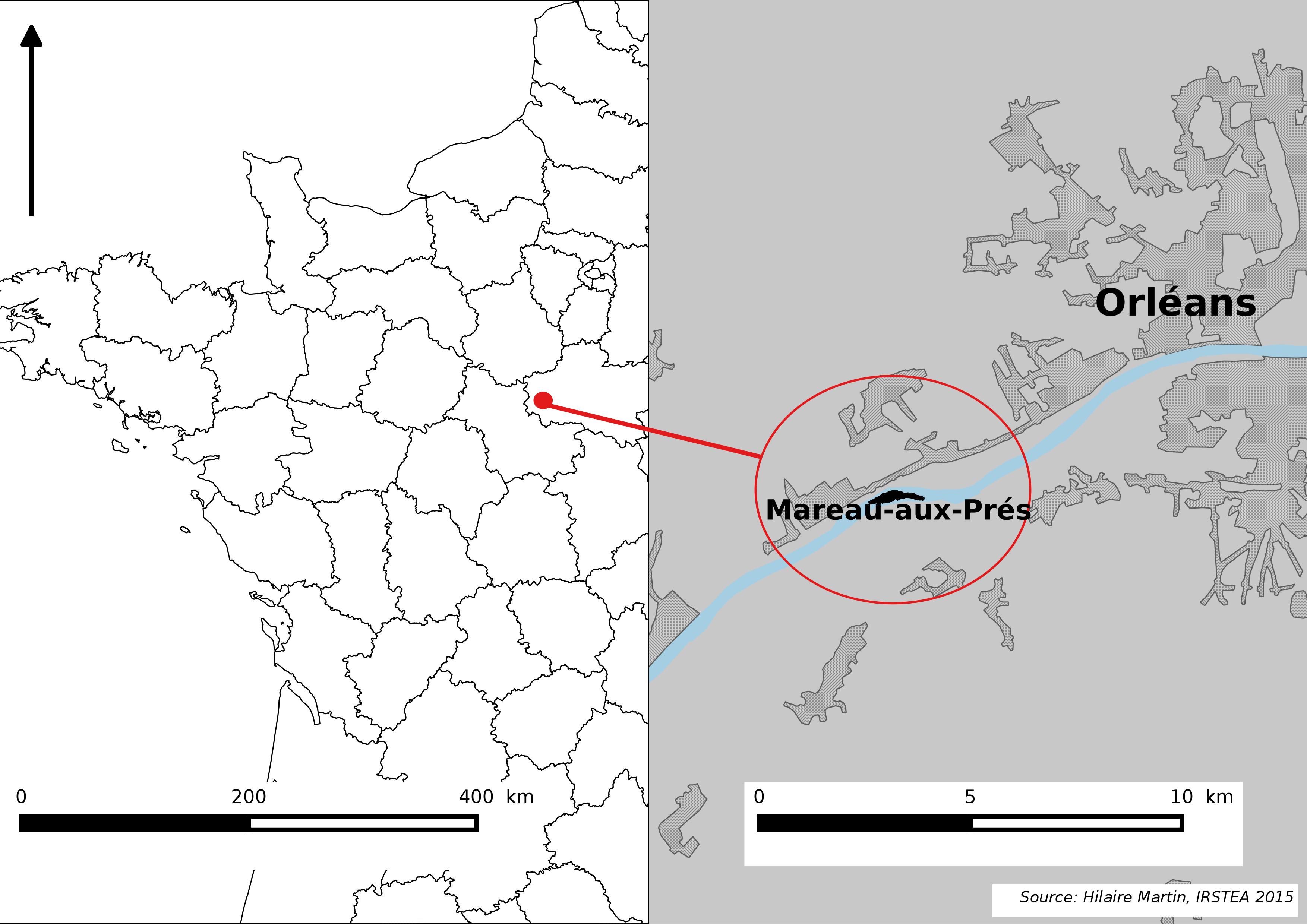
The Mareau-aux-Prés islands, along the Loire river, are characterized by a multiple channel pattern, where natural limestone riffles influence the morphology and spatial distribution of vegetated islands, secondary channels and alluvial bars. Within these islands, in september 2012, fluvial management operations (FMO) were launched. The vegetation of the central sandy-gravelly bar (3 ha area) was uprooted and the bar level lowered in order to maintain the flow capacity of the river. A new sandy-gravelly bar appeared in spring 2013, ideal field support for studying long-term ecological issues. A multidisciplinary research program (‘BioMareau’ project) is currently being conducted from 2012 to 2019, focusing on biodiversity recolonization and on interactions and feedbacks between biotic and abiotic compartments.
-

The Seine estuary is a megatidal estuary located in northern France. It is the third largest estuarine ecosystem in the country after the Gironde and Loire along the French Atlantic coast; its waters flow into the English Channel. The geographical zone of influence of the Seine estuary runs from just upstream of the Poses dam, at the limit of the tidal penetration into the estuary — 160 km upstream of Le Havre —to the eastern part of the Bay of Seine. It can be divided into three sections: the fresh water upstream section (125 km), the mixing zone characterized by varying salinity levels (35 km), and the marine downstream section under the influence of the Seine River. The megatidal regime generates a turbidity maximum in the mixing zone (middle estuary) between the marine and fluvial sections of the estuary. The Seine estuary is a typical estuarine ecosystem: highly stressed by natural fluctuations and anthropogenic pressures, and hosting a rich ecological system. The Seine valley and its estuary are of major economic importance for France, with the presence of two maritime ports. It’s watershed (79,000 km2) is the home to 17 million people, and accounts for 50 % of the river traffic in France, 40 % of the country's economic activity, and 30 % of its agricultural activities. In addition to the Greater Paris area (> 11 million inhabitants), which contributes heavily to the Seine estuary's upstream inputs, two other major river settlements — Rouen (500,000 inhabitants) and Le Havre (300,000 inhabitants) — are maritime ports of international importance. Due to economic development, the Seine estuary has been subjected to major hydrodynamic, ecological, biogeomorphological and biogeochemical changes. The importance of studying the effects of anthropogenic impacts on estuarine ecosystems has increased in the last decade, especially under the Water Framework Directive, which aims to achieve “good environmental status” of all European water bodies.