
carbon dioxide concentration
Type of resources
Available actions
Topics
Keywords
Contact for the resource
Provided by
Years
Formats
Representation types
-
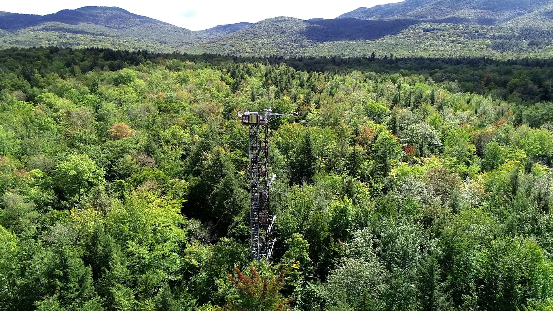
The Bartlett Experimental Forest is relocateable site in Domain 01 Northeast and the site is part of NEON's sampling design. The site is located in New Hampshire. BART extends from the village of Bartlett in the Saco River valley at 680 ft to about 3,000 ft at its upper reaches. Aspects across the forest are primarily north and east. This particular site was chosen because it represented conditions (soils, elevation, climate, tree species composition) typical of many forested areas throughout New England and northern New York. An actively managed forest: manged protions (30% reflect a range of forest patch sizes and structural distrubutions. Sampling area is 15.66 km^2. . Airborne remote sensing surveys of this field site collect collect lidar, spectrometer and high-resolution RGB camera data. The flux/meterological tower at this site is 116’ with 6 measurement levels. The tower top extends above the vegetation canopy to allow sensors mounted at the top and along the tower to capture the full profile of atmospheric conditions from the top of the vegetation canopy to the ground. The tower collects physical and chemical properties of atmosphere-related processes, such as humidity, wind, and net ecosystem gas exchange. Precipitation data are collected by a tipping bucket at the top of the tower and a series of throughfalls located in the soil array. This site has five soil plots placed in an array within the airshed of the flux tower. Field ecologists collect the following types of observational data at this site: Terrestrial organisms (birds, ground beetles, mosquitoes, plants, small mammals, soil microbes, ticks), Biogeochemical data, and and soil data. Total data products collected at this site is 116.
-
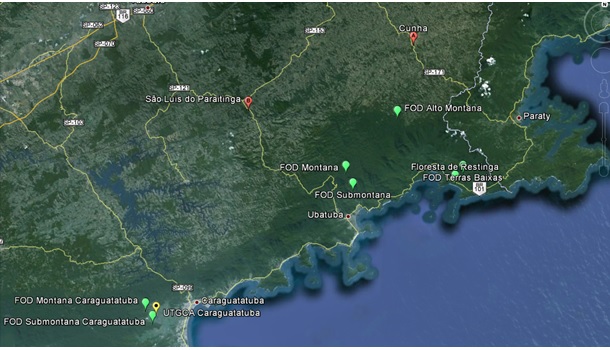
This research site develops long-term ecological studies in experimental units located in Protected Areas along the altitudinal gradient of Atlantic Forest types: Low Altitude Ombrophilous Dense Forest (5 to 50 m above sea level), Submontana Ombrophilous Dense Forest (50 to 500 m above sea level), and Montane Ombrophilous Dense Forest (500 to 1.200 m above sea level). In each altitude, all trees with a DBH ≥ 5,0 cm that fall inside 4 independent 1 hectare permanent plots, divided into a grid of 10 x 10 meter parcels, are being considered. The site extends from 23°15' S a 23° 40 S to 44° 40’ a 45° 40’ W. within areas of the Nucleus Caraguatatuba, Cunha, Picinguaba and Santa Virginia from the Serra do Mar State Park/PESM. The database on composition and structure of the forest will allow a choice of species for more detailed studies on reproduction biology; seed anatomy and reserves; germination; photosynthesis and water use efficiency; nitrogen assimilation, transport and metabolism; plant populations structure and dynamics; techniques; genetic structure of plant populations using molecular markers; determination of forest age by DBH classes and using 14C; determination of annual average growth rates of key species; and phenology. Multivariate analyses has been used to check for functional groups, or groups of species that share a common behavior and ecology. The comparison of different groups along the altitudinal gradient will allow investigation of the effect of altitude in the functioning of these groups. Simultaneously, the inputs of nitrogen through precipitation, biological fixation, and soil mineralization and nitrification are being determined, along with key parameters of N losses through denitrification and export by streams, allowing a preliminary nitrogen mass balance along the altitudinal gradient. Water and carbon balance of the forest will be estimated along with the seasonal variation of this balance through use of micrometeorological towers and Eddy-covariance technique. The photosynthesis/respiration balance of the ecosystem will be used to determine the role of the forest as a sink or source of carbon to the atmosphere. Our final goal is to integrate the results of all activities listed above, scaling-up from individual trees, to families, to functional groups, and finally to phytophysiognomies, allowing us to investigate in detail the structure and the functioning of the forest.
-
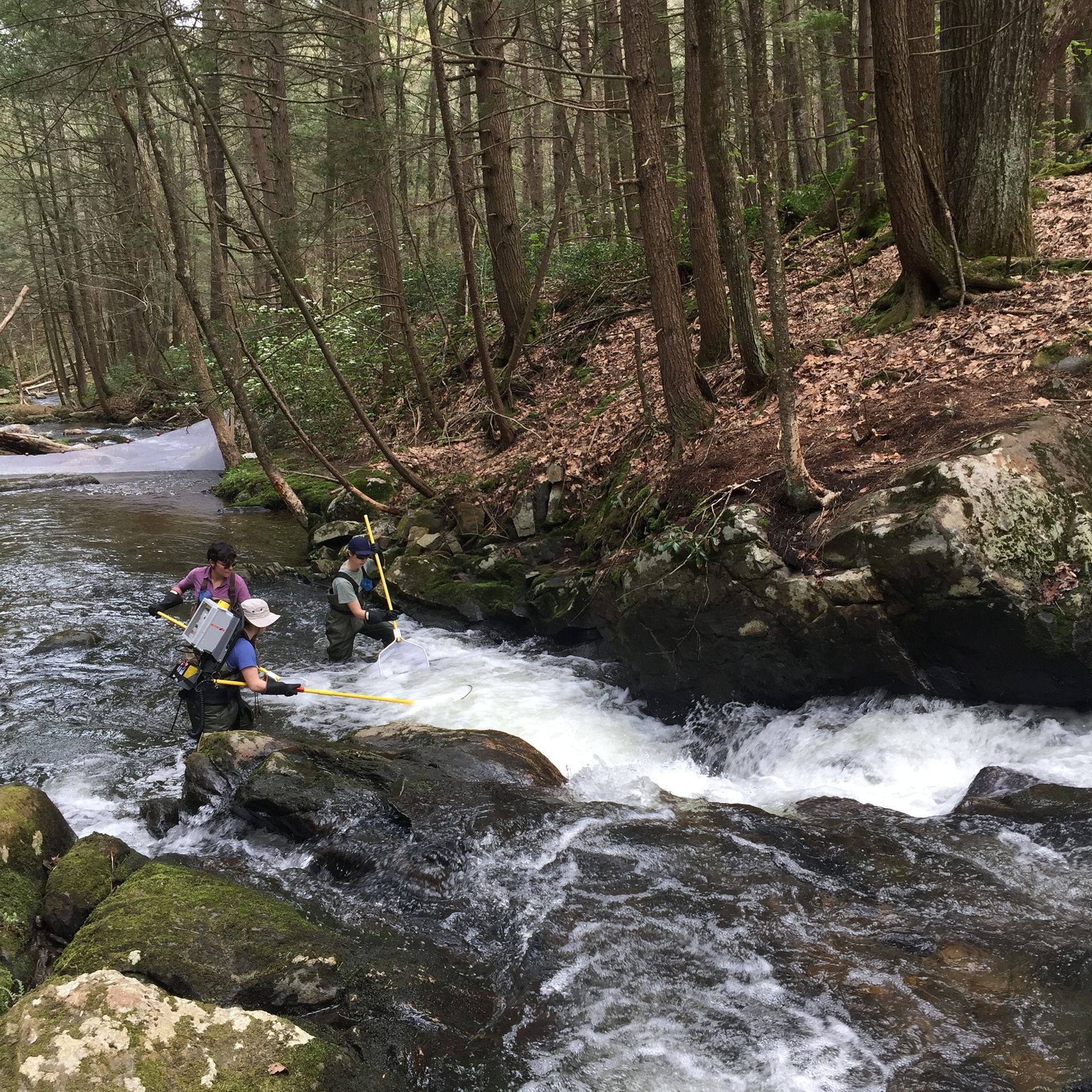
The Lower Hop Brook is a core aquatic site in Domain 01 Northeast in Massachusetts. HOPB site is a 3rd-4th order wadeable stream that flows into the Quabbin Reservoir in central Massachusetts. The section of stream selected by NEON flows from Shutesbury Road to the inlet of reservoir. Several beaver dams and ponds characterize the area upstream of Shutesbury Road. The Lower Hop Brook site is a clear-water, moderate gradient stream with gradient increasing as the stream approaches the reservoir. Minimal beaver activity (dams, ponds) is anticipated in the upper portions of the reach during the life of the NEON project. Large debris dams characterize the reach downstream. Substrate ranges from sand to cobbles, boulders, and finally bedrock outcrops downstream. The stream canopy is predominantly a mixed deciduous, northern hardwood forest with beech trees near the stream. Total data products collected at this site 78.
-
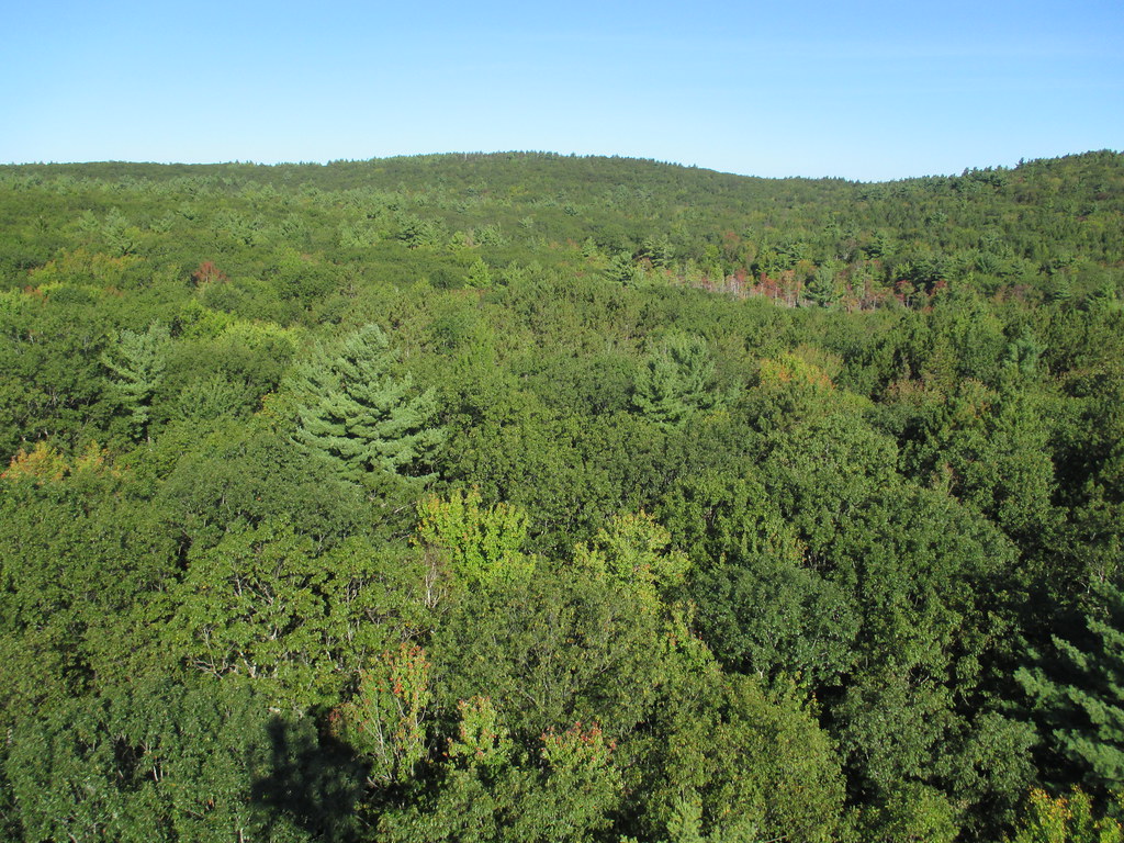
Harvard Forest is a core site in Domain 01: Northeast. Located 73 miles from Boston in Petersham, Massachusetts The Harvard Forest site is spread across 49 km2 of land and is the core NEON site for the Northeast region. Representative habitats at Harvard Forest include northern, transition, and central forests; marshes, swamps, and conifer-dominated bogs; and forest plantations. NEON's meteorological/flux tower and tower sampling plots are located on land owned by Harvard Forest - Harvard University, LTER an forest with a rich history of scientific research. The distributed sampling plots are located along the edge of the Quabbin reservoir which is managed by the Massachusetts Department of Conservation and Recreation, Division of Water Supply Protection. For access to the area along the Quabbin, visitors must be accompanied by a NEON project employee. Total data products collected at this site is 119.
-
In Doñana a manual weather station exists since 1978 equiped with analogical instruments from which EBD-CSIC personnel once a day, records maximum and minimun air temperature and total precipitation. This manual station has been supervised by the State Meteorological Agency (AEMET) until 2008. Since 2008, on the same site, AEMET has installed a new measurement station with modern instrumentation that allows automated data recording (temperature, precipitation, wind, humidity, etc.). Since November 2008 EBD-CSIC installed additional weather stations on different sites and varying time intervals, consisting of a multisensor of VAISALA brand. At some of these measure points other data related to the study of climate (soil humidity, soil temperature, solar radiation, CO2 flow, etc.) are being recorded. Additional weather stations in or near the Doñana area are managed by the Ministries of Agriculture and Environment of the Junta de Andalucía and by research entities like the National Institute for Aerospace Tecnology (INTA) and the Geological and Mining Institute of Spain (IGME)
-
The typical vegetation of the forest is natural conifer-broadleaved mixed forest, dominated by Betula ermanii, Abies sachalinensis, Picea glehnii, Quercus crispula, and Acer mono, with dwarf bamboo species in the understory. The mean annual temperature is 5.4 ºC and the mean annual precipitation is 1,449 mm.
-
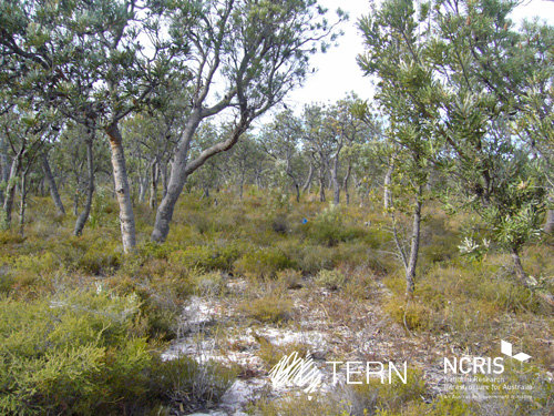
Gingin Banksia Woodland SuperSite is located on the Swan Coastal Plain, approximately 10 km southwest of Gingin, near Perth, Western Australia, sited on land traditionally owned by the Yued group of the Noongar people. The site has an elevation of 51 m and 2 km from the University of Western Australia International Gravity Wave Observatory. The Gingin Banksia Woodland SuperSite is located in a natural woodland of high species diversity (overstorey dominated by Banksia spp.) that overlays the Gnangara groundwater mound, Perth’s most important groundwater resource. The mean annual precipitation is 641mm for this coastal heath woodland. The overstorey is dominated by Banksia spp. mainly B. menziesii, B. attenuata, and B. grandis with a height of around 7 m and leaf area index of about 0.8. There are occasional stands of eucalypts and acacia that reach to 10 m and have a denser foliage cover. There are many former wetlands dotted around the woodland, most of which were inundated all winter and some had permanent water 30 years ago. The water table has now fallen below the base of these systems and they are disconnected and are no longer permanently wet. The fine sediments, sometimes diatomaceous, hold water and they have perched water tables each winter. There is a natural progression of species accompanying this process as they gradually become more dominated by more xeric species. The soils are mainly Podosol sands, with low moisture holding capacity. Field capacity typically about 8 to 10%, and in summer these generally hold less than 2% moisture. The water table is at about 8.5 m below the surface, and a WA Dept of water long-term monitoring piezometer is near the base of the OzFlux tower. The Swan Coastal Plain bioregion consists of five main geomorphic entities that are roughly located parallel to the coastline including three coastal sand dune systems with ages increasing inland from the coast. Banksia Woodlands is restricted to the Swan Coastal Plain IBRA bioregion and immediately adjacent areas, including the Dandaragan plateau. Vegetation consists of a prominent tree layer of Banksia with scattered eucalypts and other tree species present within or emerging above the Banksia canopy, and a diverse understorey including sclerophyllous shrubs, graminoids and forbs. The Gingin SuperSite is collocated with the Land Ecosystem Atmosphere Program (LEAP) - Gingin. The traditional owners at Gingin are the Yued group of the Noongar People.
-
The Boyagin Wandoo Woodland SuperSite was established in September 2017 by the University of Western Australia. Located in the Boyagin Nature Reserve, approximately 12 km west of Pingelly, Western Australia the SuperSite monitoring activities complement the Avon River Catchment Critical Zone Observatory at the UWA Future Farm in Pingelly that focusses on managed landscapes (rotational dryland wheat cropping and grazing pastures for sheep). The climate is Semi-arid (Dry) Warm Mediterranean. The Boyagin SuperSite is collocated with the Land Ecosystem Atmosphere Program (LEAP) - Boyagin. Boyagin SuperSite is located in the Avon Wheatbelt (AW2-Re-juvenated Drainage subregion) and has a high density of rare and geographically restricted flora and supports populations of several marsupials subject to fox predation (Numbat, Quenda, Woylie, Tammar, Red-tailed Phascogale, Brushtail Possum) that have disappeared from most of the Australian or Western Australian mainland. The Noongar people are the traditional owners at Boyagin.
-
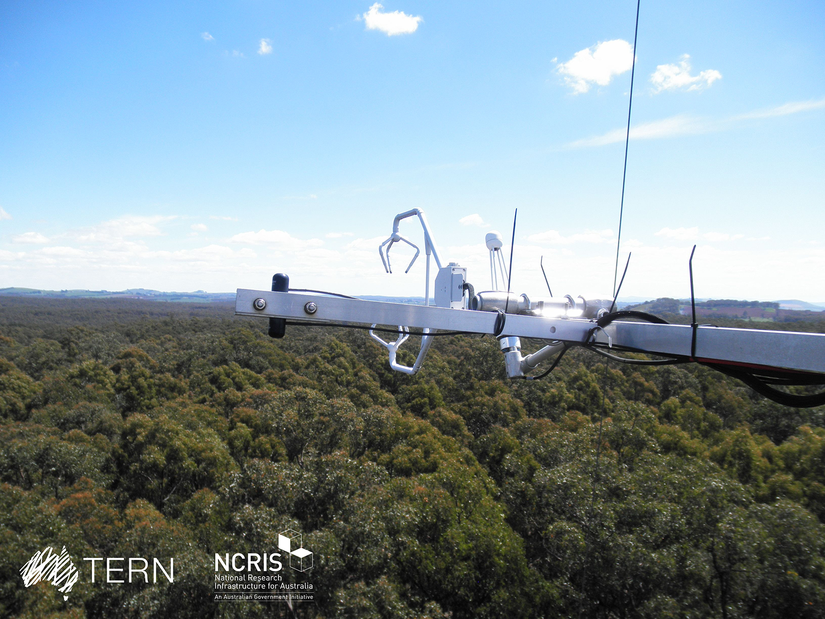
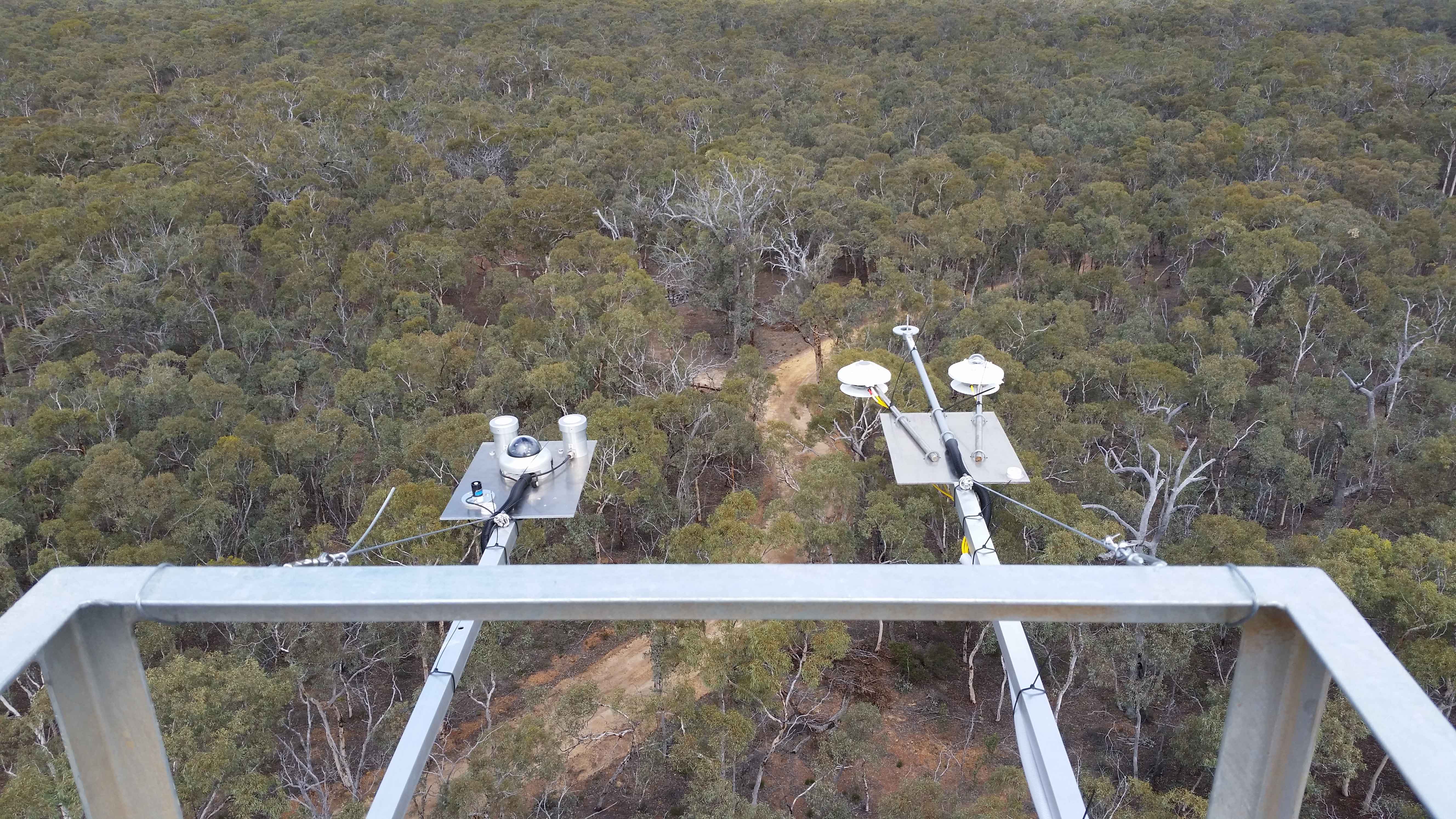
The Wombat Stringybark Eucalypt SuperSite is a member of the TERN Ecosystem Processes platform (https://www.tern.org.au/tern-observatory/tern-ecosystem-processes/), a field observatory within the Australian Terrestrial Ecosystem Network (TERN, http://www.tern.org.au/). The Wombat Stringybark Eucalypt SuperSite is located in the Wombat State Forest, Victoria, South Eastern Australia at an elevation of 713m. The site is a secondary re-growth forest that was last harvested in 1980. Dominant tree species are Eucalyptus obliqua (messmate stringybark), Eucalyptus radiata (narrow leaf peppermint) and Eucalyptus rubida (candlebark) with an average canopy height of 25 m. The understorey consists mainly of patchy grasses and the soil is a silty-clay overlying clay. The forest is managed by the Department of Environment, Land, Water and Planning and management includes selective harvesting and prescribed burning regimes. The climate of the study area is classified as cool-temperate to Mediterranean zone with cold and wet winters (May-Aug) and warm and dry summers (Dec-Feb). Key research objectives include: • What are the elements of structure, composition, functions and processes of the dry eucalypt forests of South Eastern Australia required for the sustainable management of these ecosystems? • What is the carbon sink/source strength of a dry sclerophyll forest and what is their contribution to Australia’s National Carbon Inventory? • What is the magnitude of emission and/or uptake of non-CO2 greenhouse gases, such as nitrous oxide and methane of dry eucalypt forest? • How will climate variability, drought or fire influence the ecosystem processes of dry eucalypt forest? The Dja Dja Wurrung peoples are the traditional owners at Wombat.
-
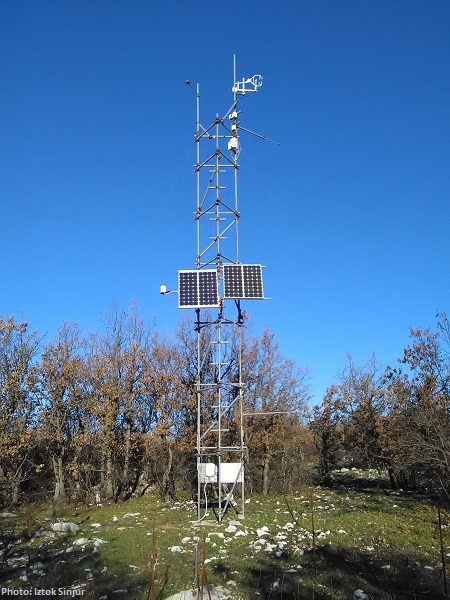
CARBON FLUXES IN TWO SUCCESSIONAL STAGES OF VEGETATION IN THE PODGORSKI KRAS. Research site represents karst grassland and different stages of secondary succession, occasionally affected from forest fires. It is located on karst plateau close to Podgorje village in the sub-mediterranean region of south-west Slovenia. The site is equipped with two Eddy Covariance towers which measure the carbon fluxes in two successional stages of vegetation. The area has undergone major human influences due to its position at the transition between the Mediterranean and central Europe. In fact, agricultural practices, such as overgrazing in the past centuries, led to pronounced destruction of the vegetation cover, causing severe soil erosion and resulting into a stony and bare landscape. However a succession is taking place and different vegetation types, ranging from grasslands to secondary oak forests, are now present. The bedrock is mainly composed of Paleocene and Eocene limestone. The chemical weathering known as karst phenomena led to the formation of Leptosols and Cambisols, which represent insoluble fractions of carbonates. As a result, the soil is superficial, with depths ranging from 0 cm to several decimeters in soil pockets between rocks. The organic matter represents about 12–15% of the topsoil. The climate is referred to as sub-mediterranean, with a mean annual temperature of 10.5 °C, a mean daily temperature of 1.8 °C and 19.9 °C in January and June respectively, and an average annual precipitation around 1370 mm. The growing season ranges from March or April to October.