
community pattern
Type of resources
Available actions
Topics
Keywords
Contact for the resource
Provided by
Years
Formats
Representation types
-
The Northeast US Shelf (NES) ecosystem spans the Middle Atlantic Bight and Gulf of Maine, is a large portion of the NW Atlantic Shelves Province, and is in a coastal biome. The waters over the NES provide an array of ecosystem services including fishing, energy development, shipping, waste disposal, recreation, and conservation. The NES ecosystem, like other productive temperate shelf ecosystems, is characterized by strong seasonality along with high levels of variability in physical forcing at timescales from days to decades, including climate impacts.
-
Studies on ecological successions have a long tradition and strongly contributed to the understanding of community assembly, niche theory and ecosystem structure and functionality. Reports on ecological successions are however mostly restricted to one or two taxonomical groups, neglecting the mutual influences and dependencies between multiple taxonomic groups that are the building blocks of multidiverse communities. We introduce the Alpine research platform Ödenwinkel to promote observational and experimental research on the emergence of multidiversity and ecosystem complexity. We established n = 140 permanent plots along the successional gradient of the forefield of the Ödenwinkelkees glacier at the end of Stubachvalley in the Hohe Tauern range (National Park Hohe Tauern, Land Salzburg, Austria). In summer 2019 we completed a first full inventory of biotic and abiotic characteristics of these plots covering the diversity and composition of vascular plants, bryophytes, arthropods and other animals, bacteria and fungi as well as some geomorphologic properties. In this paper we introduce the design of the research platform and show first results on the diversity and composition of vascular plants along the successional gradient. The Ödenwinkel platform will be available as long-term ecological research site where researchers from various disciplines can contribute to accumulate knowledge on ecological successions and on how interactions between various taxonomical groups structure ecological complexity in this alpine environment.
-
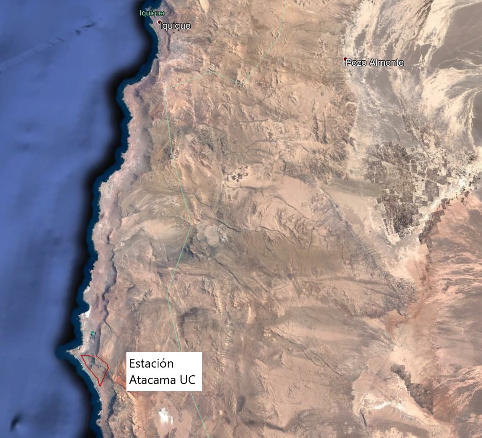
The Alto Patache fog oasis is located in northern Chile, 70 km south of Iquique, Tarapacá Region. This Oasis is located along the Coastal Range of Norte Grande, in the Atacama Desert, known for its remarkable aridity. The influence of coastal fog allows the development of a specially adapted vegetation, which provides habitat suitable for animal species.
-
South-West Bulgaria, Mediterranean catchment
-
The site corresponds to the territory of Gran Paradiso National Park. This includes different ecosystems, present along the altitudinal gradient (ca. 800 – 4000 m asl): the woody areas of the montane belt, the ecotonal habitats of the subalpine belt and the meadows of the alpine one. The nival belt is widely represented inside the Park. The habitats with poor or no vegetation (rocks, screes, glaciers) cover about 60% of the territory, meadows and pastures 17%, about 20.2% is characterised by woods and shrubs, while 0.8% by cultivated lands and urban areas. The aquatic ecosystems, beyond the streams, comprise almost 15 lakes, bigger than 10,000 m2 and located at an altitude higher than 2000 m asl. The area is directly managed by the Park Authority; research and monitoring activities are coordinated by the Sanitary and Scientific Office of the Park.
-
In order to combat the eutrophication of Lake Balaton, the Kis-Balaton Water Protection System (KBWPS) was initiated in the early 1980s. Originally, the KBWPS consisted of an 18 km2 shallow (less than 1.3 m) artificial lake system (Lake Hídvégi) and a 16 km2 wetland, which were constructed on the site of the former Kis-Balaton wetland in the mid-1980s. Later, the wetland part of the KBWPS was significantly enlarged (over 50 km2). Lake Hídvégi was designed to retain nutrients and provide ideal conditions for algae growth, while the wetland component of the KBWPS prevented these algae from entering Lake Balaton. Regular limnological, ornithological, ichthyological and plant ecological measurements are carried out in both Lake Hídvég and the wetland part of the KBWPS.
-
The site consists of high elevation vegetation in central Mediterranean basin, along the Apennines mountain range: xerophitic primary grassland (Pediculari elegantis-Seslerietum tenuifoliae) and mesophitic primary grassland (Luzulo italiacae-Festucetum macratherae), with important resident and migratory bird communities. Six plots, each one 100 m2 large, grouped in two cluster-plots including each one three plots, representative of a larger area of 0,5 km2 ca., ranging from 2100 to 2300 m a.s.l. (alpic and Mediterranean high-mountain belts.
-
The Gulf of Naples has an extension of ca 870 kmq and an average depth of 170 m. The coastal area, which is inhabited since pre-Roman age, is densely populated and small factories are actively growing. In the Gulf, polluted areas (Sarno river mouth, harbours) coexist with pristine areas, including some Protected Marine Areas. Research on marine organisms has started before since the beginning of 1800, but first ecological studies date back to the 70ies of the last century. The long-term monitoring station (LTER-MC, 40°49’N, 14°15’E) is located 2 nm off Naples city (depth ca 75 m) at the boundary between eutrophied coastal waters and oligotrophic Tyrrhenian waters. Larger areas of the Gulf have been sampled occasionally in several cruises. The MC data set represents one of the few plankton time series available in the Mediterranean Sea, and it is certainly one of the longest.
-
A Long Term Ecological Research Program -GUADALQUIVIR_LTER 1997-2022- has been maintained since 1997 at the Guadalquivir estuary. The temporal and spatial evolution of abundances and biomasses of the aquatic community species -plankton, fish, and crustacean- is monitored monthly since 26 years ago (1997 to present). Community data is resolved at different levels of the ecosystem -individuals, populations, and communities- and completed with their corresponding water environmental data -salinity, temperature, turbidity, dissolved oxygen, nutrients, pH, among others- as well as detailed information on trophic structure and biology of the main species. Since 2021 a new Spanish Science Agency project is working together with Guadalquivir-LTER on the socio-ecology of the region, management, and cooperation among different stakeholders.
-
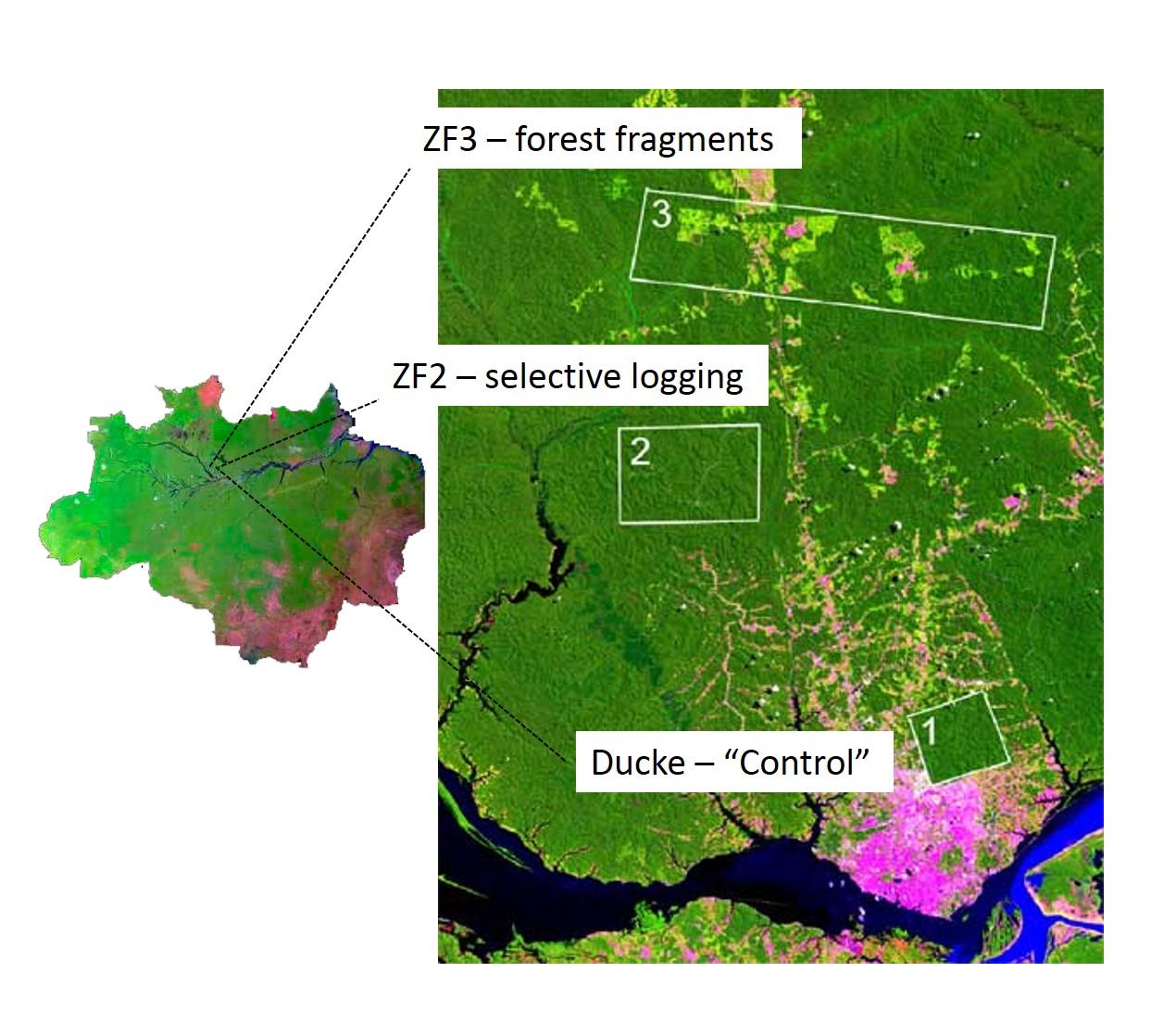
The LTER IAFA site has been running since 1999 and was the first long-term ecological research site in the Amazon. It is situated north of Manaus, central Amazon and includes three sub-sites, with undisturbed terra-firme forest (Reserva Ducke), selective logging (ZF-2 Forest Management Station), and forest fragmentation (Biological Dynamics of forest fragments – BDFFP sites) spread over around 30 x 30 km landscape. Both logging and fragmentation were carried out as controlled experiments to test their effects on biodiversity and ecosystem processes, and thus to outline recommendations for management. The 3 research areas together have 156 permanent monitoring plots, both terrestrial and aquatic, as well as grids of trails for large-scale process monitoring. The information produced has been stored on a public website (https://ppbio.inpa.gov.br/repositorio/dados) where anyone can search data and metadata about the research, as well as the list of publications and all the educational material ( books, identification guides, training course materials) for download.