
date of start of physiological maturity
Type of resources
Available actions
Topics
Keywords
Contact for the resource
Provided by
Years
Formats
Representation types
-
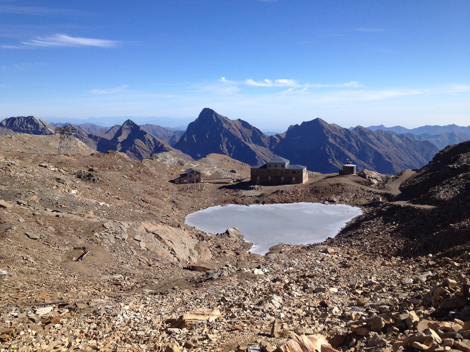
The "Istituto Scientifico Angelo Mosso" research site is located on the watershed between Piedmont and Valle d'Aosta (NW-Italy), in the Municipality of Alagna Valsesia (Monte Rosa massif). The Scientific Laboratories of the "Angelo Mosso Institute" at Col d’Olen (2901 m a.s.l.), the heart of this research site, were built between 1905 and 1907, when it became clear that the Capanna Regina Margherita on Monte Rosa (4554 m a.s.l.), as a high-elevation research centre, had become insufficient to the increasing number of requests for use by the international scientific community. From here the idea promoted by Angelo Mosso (1846-1910), professor of human physiology at the University of Turin, to add an additional structure to the Observatory of the Capanna Regina Margherita for make larger laboratories available to researchers and allow study stays at high elevation. This project soon became a reality thanks to the intervention of Queen Regina Margherita, Ministries of Education and Agriculture, the Italian Alpine Club and various personalities of the time. The research conducted at the Institute did not concern only human physiology, but also other disciplines, including alpine meteorology and glaciology, thanks also to the presence of the Meteorological Observatory that flanked the Institute, directed in the years 1925-40 by Umberto Monterin. It is now home to an automatic snow and weather station, managed by the Alpine Troops-Meteomont service. In addition to the University of Turin, the research groups that operate at the site and contribute to data collection and implementation are currently CNR-IRSA, Alpine Troops Command-Service Meteomont, Monterosa 2000 SpA and Monterosa SpA (Monterosa Ski), Protected areas of Valsesia, ARPA Piemonte, ARPA Valle d'Aosta and Sesia Val Grande Geopark. In addition to the valuable historical series of climate data, a series of research activities are devoted to the study of snow-soil-vegetation interactions, with particular reference to carbon dynamics e soil nitrogen (Magnani et al. 2017a,b; Freppaz et al. 2019). In addition, investigations are performed focusing on the chemical characteristics of high-elevation surface waters, fed by different cryospheric features such as rock glaciers, glaciers, and permafrost (Colombo et al. 2018a,b; 2019a,b; 2020; Vione et al., 2021). New research lines, aimed at investigating the most recent environmental challenges, have been added to the previous ones. For instance, investigations on sources and routes of atmospheric carbon and nitrogen species are ongoing. References: Colombo N. et al. (2018a), https://doi.org/10.1002/esp.4257. Colombo N. et al. (2018b), https://doi.org/10.1016/j.scitotenv.2018.05.098. Colombo N. et al. (2019a), https://doi.org/10.1016/j.scitotenv.2019.06.233. Colombo N. et al. (2019b), https://doi.org/10.1007/s00027-019-0670-z. Colombo N. et al. (2020), https://doi.org/10.1016/j.catena.2020.104700. Freppaz M. et al. (2019), https://doi.org/10.3897/natureconservation.34.30737. Magnani A. et al. (2017a), https://doi.org/10.1657/AAAR0016-037. Magnani A. et al. (2017b), https://doi.org/10.1016/j.catena.2017.03.007. Vione D. et al. (2021), https://doi.org/10.1016/j.scitotenv.2020.143464.
-

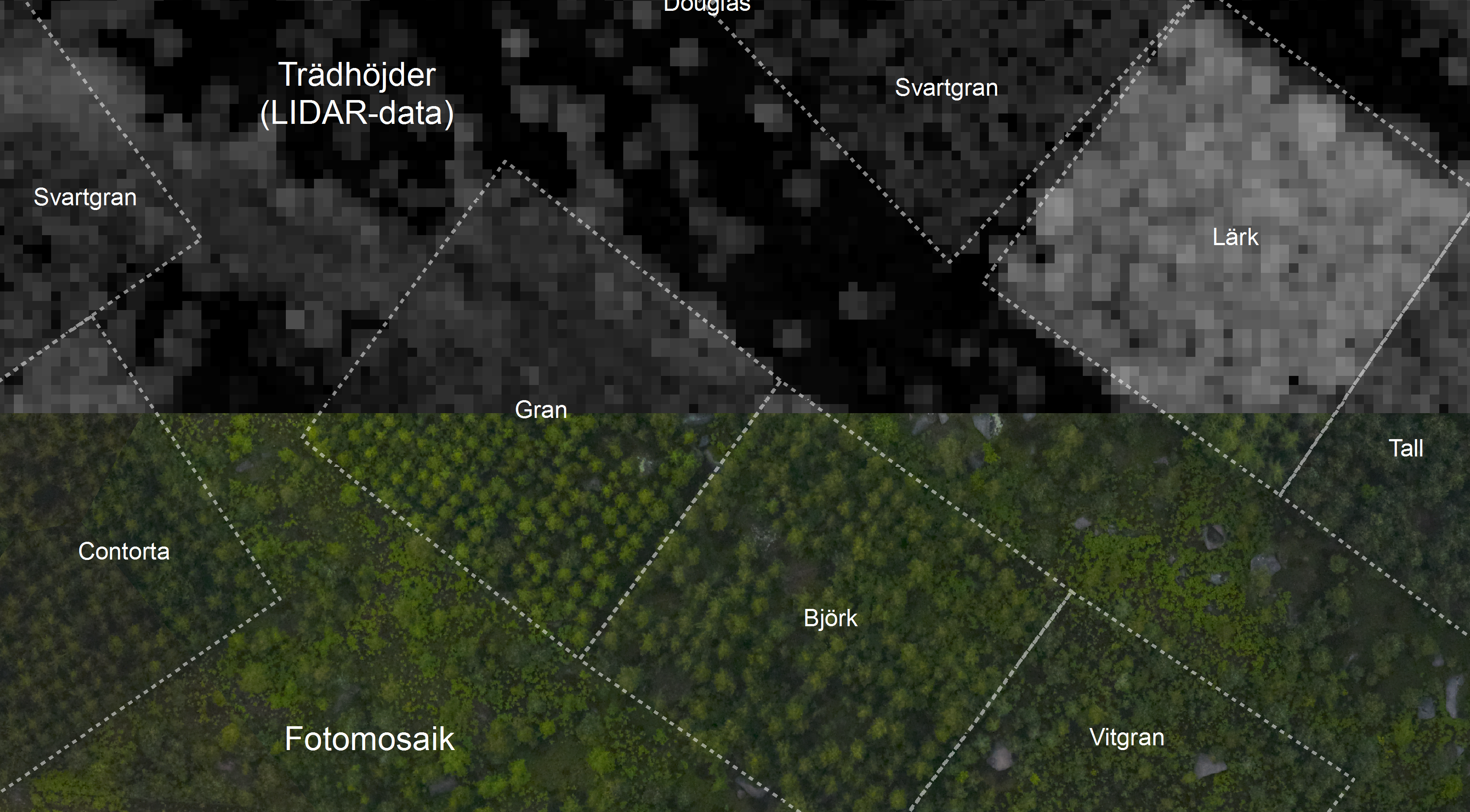
The Hölstein site is located in in the eastern part of the Swiss Jura mountains (47°26’16.4’’, 7°46’31.1’’; 540 m a.s.l.), in a mixed, temperate forest with an exceptionally high biodiversity and a vigorous tree regeneration. The research plot has a size of 1.6 ha and comprises 540 mature trees. The main tree species are Fagus sylvatica and Picea abies with an admixture of Abies alba, Quercus petraea, Pinus sylvestris, Acer pseudoplatanus, Carpinus betulus, Fraxinus excelsior and Sorbus torminalis. A canopy crane is installed in the center of the research area to access the tree canopies for in situ measurements and for sampling of leaf material. Rainout shelters will be installed in 2019 for conducting a long-term throughfall exclusion experiment.
-
Shennongjia Station is located in Xingshan County, Hubei Province, China. It is located in the southern slope of Mount Shennongjia. The altitude is 1290m above sea level. The typical forest types are the northern subtropical mixed evergreen and deciduous broadleaved forest. Shennongjia Station was established in 1994, it became a station of National Field Research Station network running by the Ministry of Science and Technology of the People’s Republic of China in 2005, and became a member of Chinese Ecosystem Research Network (CERN), CAS in 2008.
-

Tronchaney, Conca di Torgnon, (Torgnon, Aosta), + 388330 + 5075950; Aosta Valley
-
Tellinod, Conca di Torgnon, (Torgnon, Aosta), +389680 +5077920; Valle d'Aosta region
-
The Aelmoeseneie Forest is a 28.5 ha mixed deciduous forest in the community of Gontrode, just southeast of Ghent. The largest part of the forest is ‘ancient forest’, i.e. it is permanently forested since before 1775, while the forest is surrounded by agricultural land (mostly pastures). The soil consists of a silt loam to loam soil (Planosol), overlaying a mosaic of tertiary clayey and sandy deposits with high base saturation starting at 50 cm depth. Forest management is designed to obtain a more natural tree species composition and to conserve biodiversity. More info can be found at www.aelmoeseneiebos.ugent.be.
-
The Asa LTER site consists of 5 subsites; the Asa Experimental Forest, the Asa Experimental Production Forest, the FutMon-sites Sandbäcken and Ängavägen, and the IM site Aneboda. The Asa LTER site is situated in the nemo-boreal forest in south-central Sweden. It consists of five areas, integrated both geographically and thematically. The Asa Research Station has on-site permanent staff responsible for research and monitoring activities. Field laboratories and modern equipment are available as well as offices, lecture/meeting rooms, working rooms and lodging nearby.
-
The Matta LTER station studies the effects of climate change on the structure and function of Mediterranean shrubland ecosystems in Israel
-
Established in the 1950's, the Hubbard Brook Experimental Forest (HBEF) is located in the southern part of the White Mountain National Forest (WMNF) in central New Hampshire, USA. HBEF, and the broader WMNF have hilly, occasionally steep topography; coarse, acidic, glacially-derived soils; bedrock dominated by metamorphic rock of igneous and sedimentary origin; northern hardwood forests on lower slopes and spruce-fir forests at higher elevations (above ca. 800 m).
-
Intensive Forest Monitoring site with Pinus silvestris - Betula pendula forest