
diet composition
Type of resources
Available actions
Topics
Keywords
Contact for the resource
Provided by
Years
Formats
Representation types
-
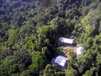
The site comprises 10,000 ha of pristine lowland rainforest in northern Papua New Guinea, owned by indigenous landowners from Wanang Village and declared as Conservation Area. The forest has >500 species of woody plants and largely intact, mildly hunted vertebrate communities. The site includes a field research station (phone, radio, accommodation, catering, solar power) accessible on foot or by helicopter. Further, the site has 50-ha forest dynamics plot from the Center for Tropical Forest Science network, with >300,000 stems tagged and monitored from 2012. There is significant background information on plants, birds, frogs, and several insect taxa. Insect monitoring programme is planned from 2013.
-
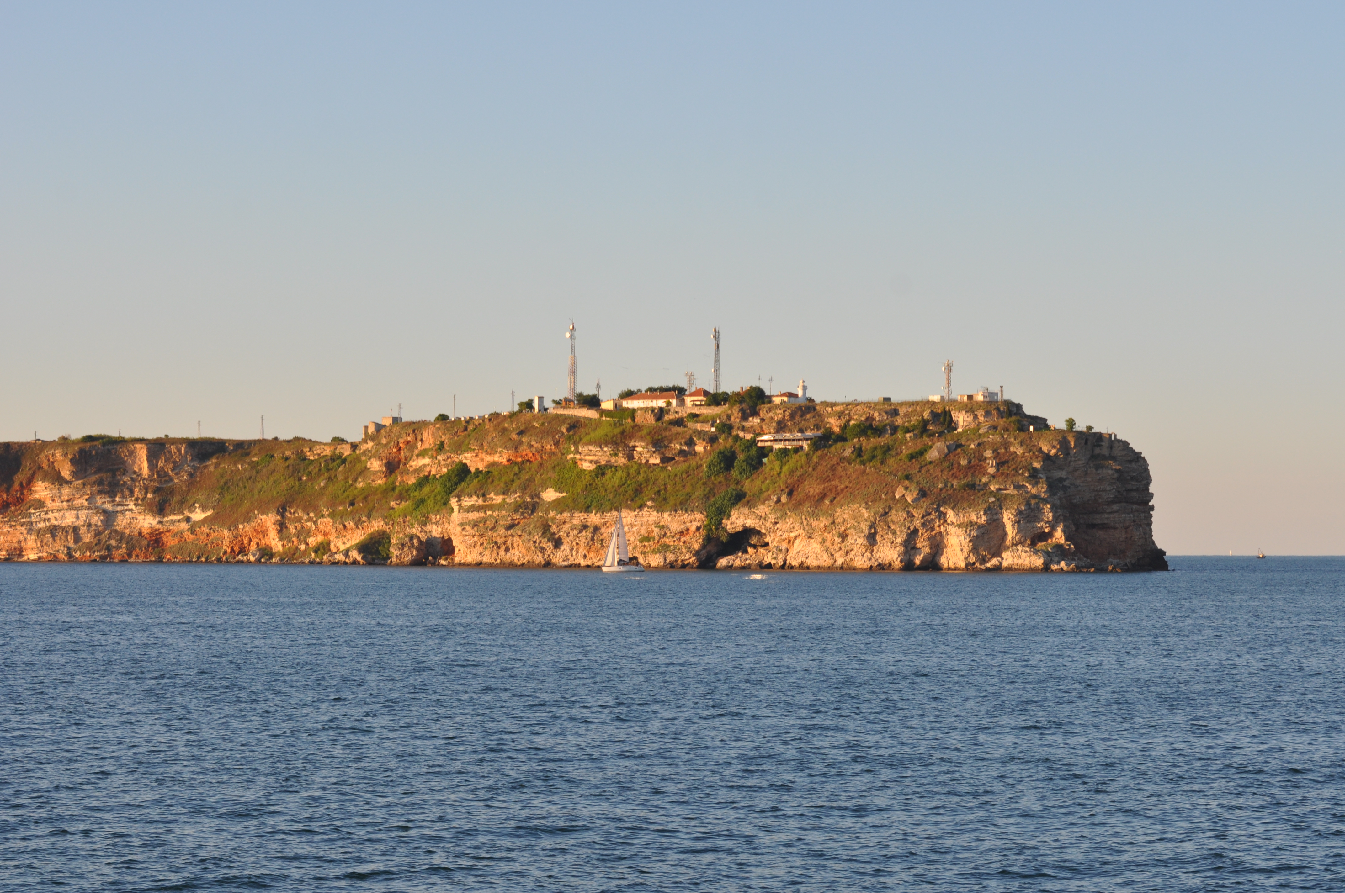
Black Sea site includes three areas: cape Kaliakra, cape Galata and Varna Bay, and Koketrays Sand bank (only for macrozoobenthos). They were chosen on the base of historical data availability and eutrophication/pollution impact. Kaliakra marine area is influenced by eutrophication due to mainly the Danube river inflow. The local anthropogenic impact in the region is insignificant. It is a nature reserve. Cape Galata and Varna Bay sites are under the indirect impact of Varna Bay current and the system Beloslav lake-Varna lake - a cascade introducing nutrients and pollutants of industrial (chemical industry), agricultural, sewage origin and nearby ports. Koketrays Sand bank is an unique benthic habitat. The coordinates of the selected areas are as follow: c. Kaliakra: 28.416667 43.366667 c. Galata: 27.933889 43.186111 Varna Bay: 28.166667 43.166667 Koketrays bank: 27.888889 42.635556
-
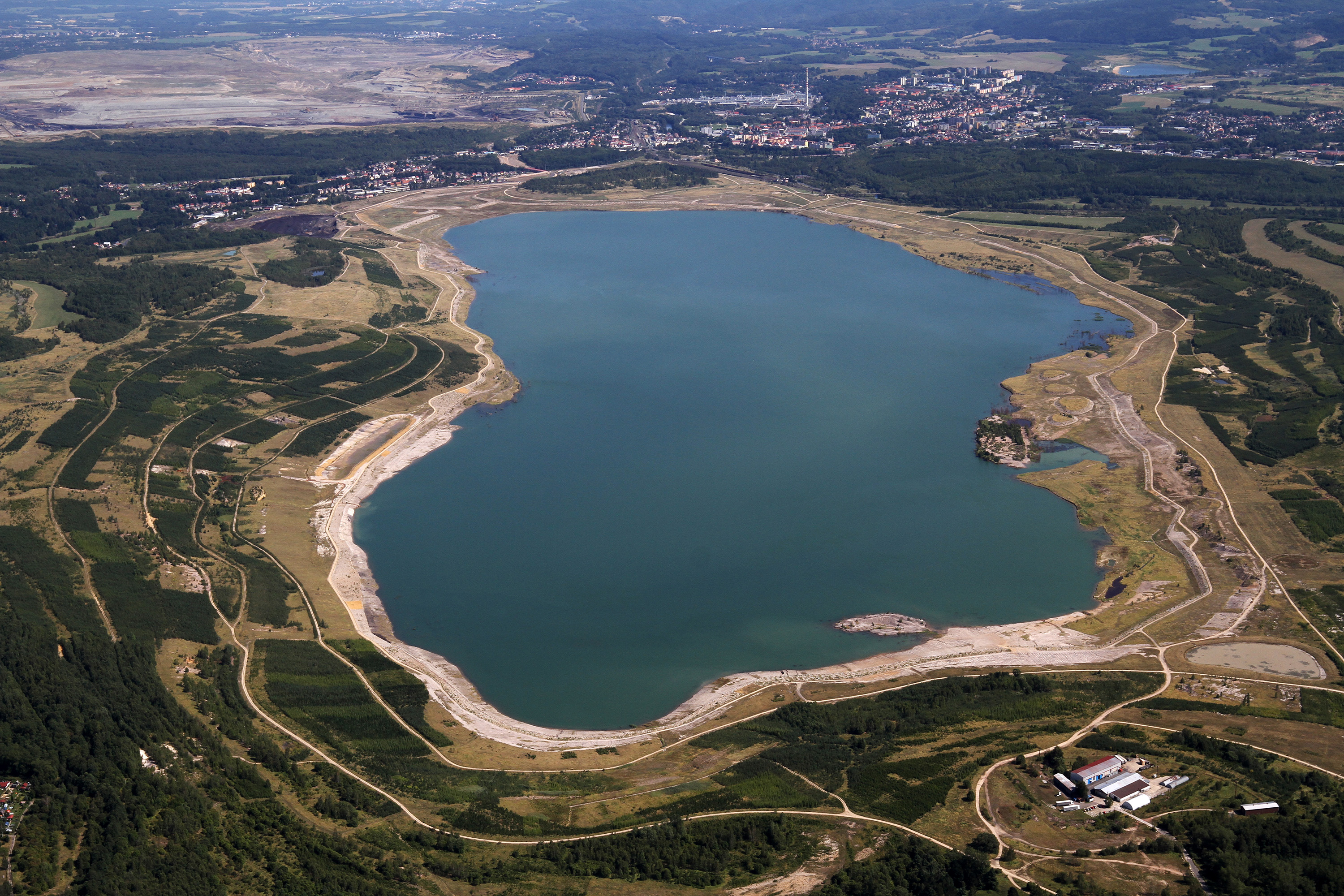
Large-scale opencast mining of brown coal represents a significant and devastating intervention in the natural environment. As a close to nature and economically acceptable method of reclamation of residual mine pits, the hydric method of reclamation is used, when lakes are created from quarries. The creation of a new lake in a former mining area essentially represents a large-scale ecological experiment, during which a number of specific factors are involved with impacts on individual organisms, multiple trophic levels and interactions, even entire food chains, and ultimately the lake water quality. Post-mining lakes (Medard Lake – 490 ha, max. depth 50 m, 400 m a.s.l., Milada Lake – 245 ha, max. depth 25 m, 145 m a.s.l., Most Lake – 310 ha, max. depth 75 m, 199 m a.s.l.) thus represent unique LTER areas for studying ecological processes in large natural lentic ecosystems. The ongoing research is focused mainly on (i) the structuring effect of submerged macrophytes on trophic relationships and distribution of fish in deep lakes, (ii) the effects of intra- and interspecific interactions on the succession of fish communities, and (iii) the effects of anthropogenic use and long-term changes on water quality, composition, periphyton composition and phytoplankton structure and biomass.
-
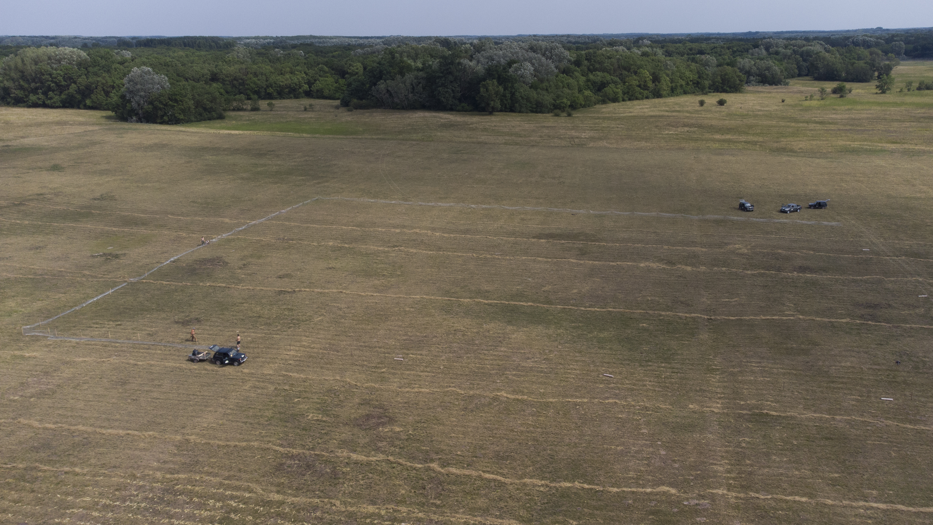
The site is a revitalized young steppe habitat patch, dominated by fescue (Festuca rupicola). The average altitude is around 100 m. The site is a grazing spot and it was recently used for the reintroduction of the European ground squirrel (Spermophilus citellus) to the area after 70 years. Other important species present at the site include Vojvodina blind mole rat (Nannospalax (leucodon) montanosyrmiensis) and Spring meadow saffron (Bulbocodium versicolor).
-
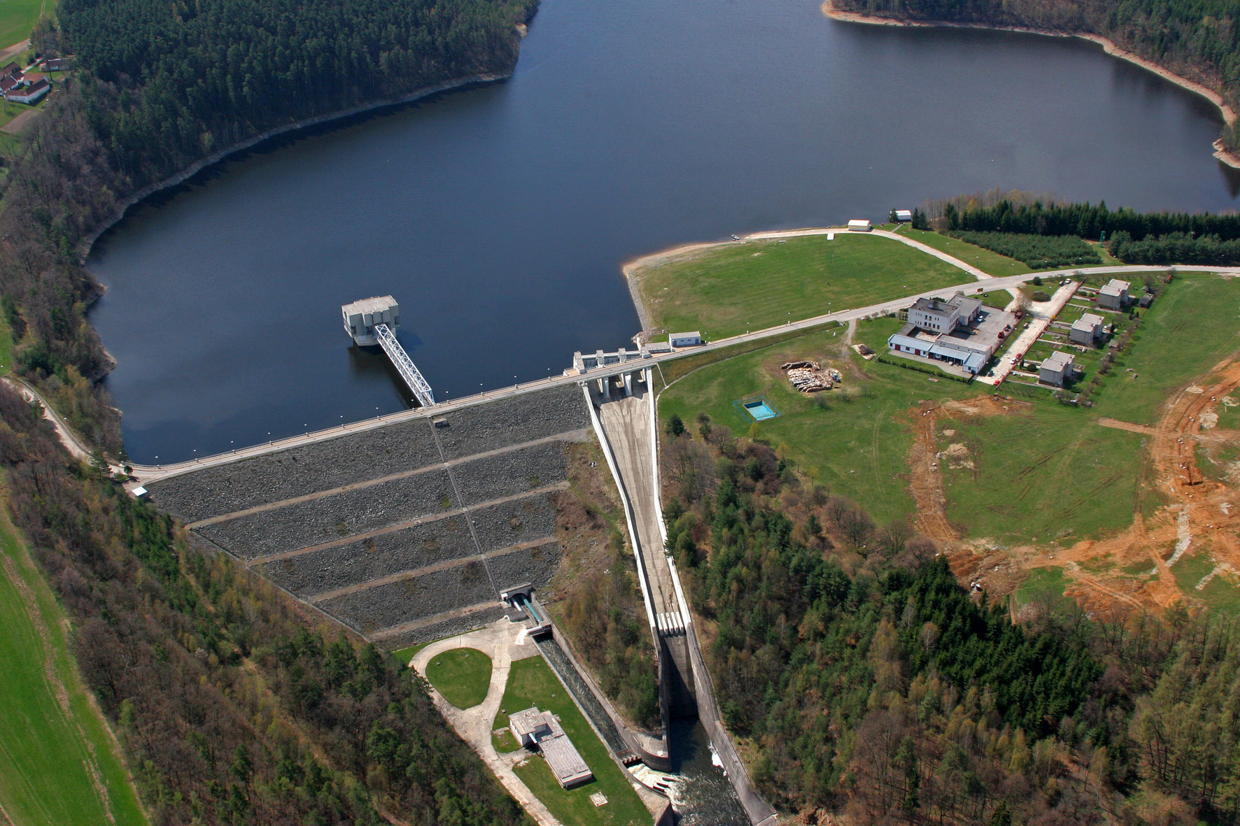
The Římov Reservoir was constructed in 1971–1978 at 21.85 km of the Malše River (tributary of the Vltava River), downstream its confluence with the Černá stream. The reservoir serves as an important drinking water supply for South Bohemia and helps to maintain a minimum flow downstream. The dam is 47 m high and 290 m long. Reservoir volume is 34.3×10⁶ m3, the catchment area is 489 km2.Mean annual flow is 4,3 m3 s-1 and mean theoretical water retention time 92 days. The Římov Reservoir is a canyon-shaped impoundment with steep banks, the „tower“ for drinking water input is at 5 m distance from the dam. Being a drinking water source, Římov Reservoir is protected and no other uses are allowed. Regular investigations of the Římov reservoir in its lacustrine part started in 1979 and have continued at three-week intrevals up to now. Since 1997, the Římov reservoir has been a part of the Czech LTER network. The parameters studied include physical, chemical and biological data on pelagic organisms like bacteria, protists, phytoplankton and zooplankton. Once per year, the abundance and species composition of fish is investigated. Besides regular monitoring, a lot of extensive studies were done of pelagic organisms, their diversity, interactions and functions as well as chemical processes in water and sediment, both in the lacustrine part and in the canyon-shaped riverine part near the inflow. Such intense studies were possible due to the vicinity of well equipped labs in České Budějovice and the construction of a field station at the dam (in 1994).
-
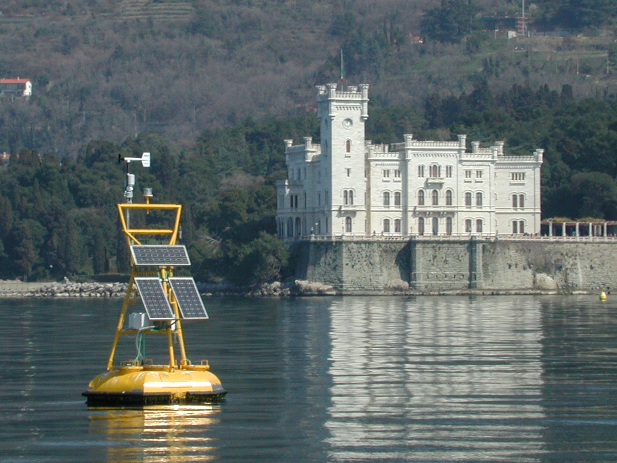
The coastal marine observatory site Gulf of Trieste lies within the Marine Protected Area (MPA) of Miramare and includes the biological time-series station “C1”, part of the Italian Long-Term Ecological Research (LTER) network, and the in situ continuous MAMBO meteo-oceanographic buoy. Marine Protected Areas represent one of the most effective systems for marine biodiversity preservation and management. Since 1986, the time-series station “C1” in the Gulf of Trieste (GoTTs, Gulf of Trieste Time series) represents a crucial site for marine ecological research, as it is subject to the interaction among several natural forcing (river, groundwater discharge, tides, general circulation, intense meteorological) and numerous anthropogenic activities (maritime transport, harbours of Trieste and Monfalcone, urban waste discharge, mussel- and fish-farming, fishing and recreational activities). In 1999, the ecological research site has been equipped with a meteo oceanographic buoy (MAMBO) in order to acquire continuous data on meteorological conditions at sea and on seawater physical and biogeochemical properties. Due to the high temporal dynamics of ecological processes in coastal ecosystems, continuous and real-time data of the main meteorological, physical and biogeochemical properties are fundamental for a better understanding of marine ecosystem functioning.
-
Lake Orta is a deep subalpine lake, located in Northern Italy, at a mean altitude of 290 m a.s.l. Its perimeter is 33,8 km, surface area 18,14 km2, volume 1,29 km3. Lake Orta has a maximum depth of 143 m and a mean depth of 71 m. Lake Orta is well known for being polluted by industrial discharges (copper sulphate and ammonia) since the late 1920: as a consequence, the pH of the lake water dropped down till 4 and the food web was almost completely destroyed, except for some few, strongly adapted species. The pollution stopped around mid 1980s and a liming intervention was carried out in 1989-1990, to neutralize the acidic waters of the lake. The recovery was very fast, new species started to colonise the lake just after the liming. The lake, however, is still at risk, due to the large amount of heavy metals stored in the sediments.
-

The Seine estuary is a megatidal estuary located in northern France. It is the third largest estuarine ecosystem in the country after the Gironde and Loire along the French Atlantic coast; its waters flow into the English Channel. The geographical zone of influence of the Seine estuary runs from just upstream of the Poses dam, at the limit of the tidal penetration into the estuary — 160 km upstream of Le Havre —to the eastern part of the Bay of Seine. It can be divided into three sections: the fresh water upstream section (125 km), the mixing zone characterized by varying salinity levels (35 km), and the marine downstream section under the influence of the Seine River. The megatidal regime generates a turbidity maximum in the mixing zone (middle estuary) between the marine and fluvial sections of the estuary. The Seine estuary is a typical estuarine ecosystem: highly stressed by natural fluctuations and anthropogenic pressures, and hosting a rich ecological system. The Seine valley and its estuary are of major economic importance for France, with the presence of two maritime ports. It’s watershed (79,000 km2) is the home to 17 million people, and accounts for 50 % of the river traffic in France, 40 % of the country's economic activity, and 30 % of its agricultural activities. In addition to the Greater Paris area (> 11 million inhabitants), which contributes heavily to the Seine estuary's upstream inputs, two other major river settlements — Rouen (500,000 inhabitants) and Le Havre (300,000 inhabitants) — are maritime ports of international importance. Due to economic development, the Seine estuary has been subjected to major hydrodynamic, ecological, biogeomorphological and biogeochemical changes. The importance of studying the effects of anthropogenic impacts on estuarine ecosystems has increased in the last decade, especially under the Water Framework Directive, which aims to achieve “good environmental status” of all European water bodies.
-

Berchtesgaden National Park was established in 1978 and is the only German national park located at the Alps. It comprises three major valleys and covers an elevantional range from 600 to 2700 m. Ecosystems include montane mixed forest and subalpine coniferous forest, alpine grasslands, pastures and rocky habitats. The Department for Research and Monitoring is linked to the Techincal University of Munich. It conducts monitoring on climate, hydrology, ecosystem dynamics and biodiversity. Main research topics include drivers of natural ecosystem dynamics, human impacts on ecosystems and climate change effects on ecosystems.