
diffuse solar radiation intensity
Type of resources
Available actions
Topics
Keywords
Contact for the resource
Provided by
Years
Formats
Representation types
-
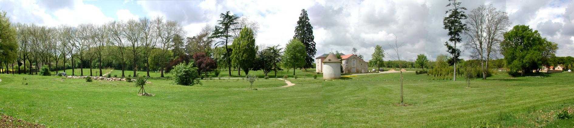
Located 2 km east of the Science Campus of the University of Poitiers, the Hydrogeological Experimental Site (HES) occupies an area of 12 hectares on land belonging to the University. From the geologic viewpoint the SEH occupies the north flank of the “Seuil du Poitou”, a huge Mesozoic carbonate plateau marking the transition between the Aquitaine and Paris sedimentary basins. The studies conducted at the SEH focus mainly on the Dogger Aquifer. The experimental layout now comprises 35 boreholes, including two vertical and two inclined cored holes.
-
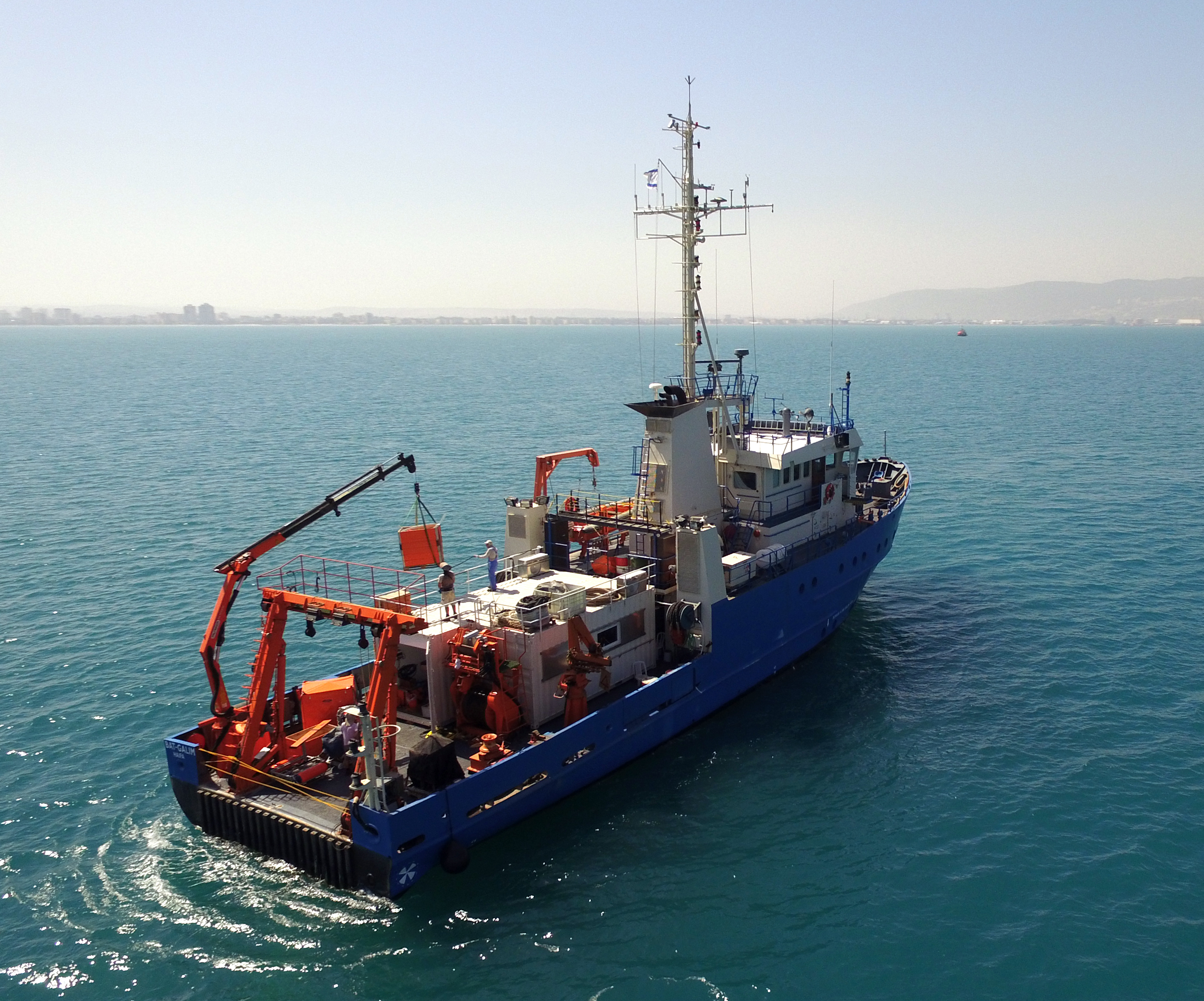
The National Institute of Oceanography (IOLR) is located in Haifa (Tel Shikmona) on the shores of the Mediterranean Sea. The institute engages in research and development in marine sciences and provides information and professional advice to the government and the public sector in the context of the sustainable utilization and conservation of Israel’s marine and coastal resources. The oceanographic studies at the institute are engaged in research, monitoring, and collecting environmental data in the Mediterranean Sea, and in studying natural and unnatural processes. The research topics at the institute include subjects such as; flow and mixing processes; oceanographic models; material cycles; sediment transportation and geological processes; the structure of the seabed; physiology, immunology, and ecology of marine organisms and the populations’ dynamics; the biological diversity in offshore waters and deep seas; effects of human activity on the open sea and coastal environment. IOLR operates advanced instruments and national infrastructures for marine research and monitoring, such as; the national research vessel “Bat Galim”, small ships, and autonomous underwater gliders. A variety of mapping, sampling, data collection, and independent systems are placed at sea for continuous monitoring of environmental variables. In addition, ecological monitoring (community structure, biological diversity, etc.) is carried out in several habitats at a monthly to yearly frequency as follows: • Seasonal ecological monitoring of the Benthos community of the vegetation tables in four sites from north to south since 2009 (also includes a monthly sampling of the water - chlorophyll, nutrients, alkalinity, DIC, temp., pH). • Seasonal ecological monitoring of the benthos community (fish, and biotic cover) of the shallow reefs in the Shekmona/Rash Carmel area. • Annual ecological monitoring of the mesophotic reefs (90-100 meters) at the top of Carmel and the shallow reef. • Monthly zooplankton monitoring at the Hadera station • Monitoring the fish society and the invertebrate community in sandy bottoms • Deep sea monitoring IOLR operates the National Marine Information Center - ISRAMAR, which collects, records, and distributes data and information regarding Israel’s marine environment.
-
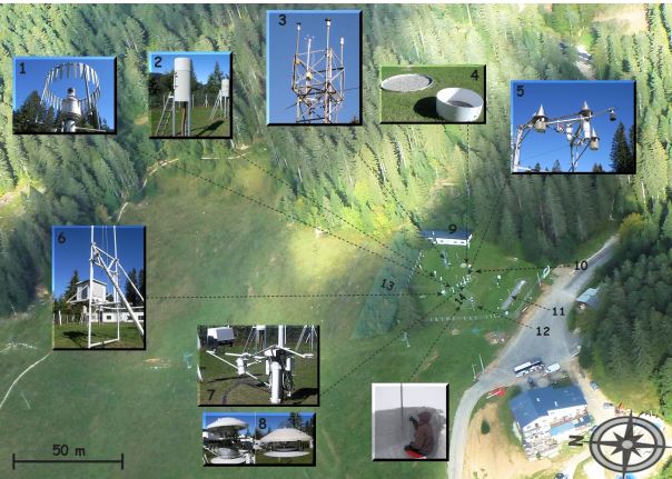
The Col de Porte pilot site is located near Grenoble, in the Chartreuse massif (elevation : 1325m, latitude : 45°30’N, longitude : 5°77’ E). At this mountain site located in a grassy meadow surrounded by a coniferous forest; all the measurements are located within an flat area of 50 × 50 m. Meteorological and snow parameters are recorded hourly since 1961. These parameters are : - Air temperature and relative humidity of air - Incoming and outcoming short and long-wave radiations - Wind speed and direction - Precipitation - Snow depth, snow water equivalent - Settlements and snow temperatures of the different layers of the snowpack Weekly snowpack profiles are also carried out, including major stratigraphic properties of snow (temperature, density, liquid water content, snow type). All sensors are located within a radius of a few tens of meters. (1) Geonor precipitation gauges (3 sensors) and OTT2 (1 sensor), (2) PG2000 heated and non-heated precipitation gauges, (3) windspeed measurements at the top of the 10 m meteorological mast and at the same level of the precipitation gauges, (4) lysimeters (2 sensors), (5) snow depth and surface temperature sensors and settling disks, (6) temperature and relative humidity of air sensors placed in the shelter, (7) Incoming and outcoming longwave and shortwave radiation sensors placed on the rotating arm, (8) close-up on the 4 components radiation sensors, (9) building (cold room, data acquisition, lab space), (10) cosmic rays counter for SWE measurements, (11) former experimental area for the study of road/snow interactions, (12) automatic snow and weather station Nivose for testing purposes (generally used in remote mountain areas), (13) forest area impacted by the cut in 1999, (14) snow pit area, Fore more information refer to : Morin, S., Lejeune, Y., Lesaffre, B., Panel, J.-M., Poncet, D., David, P., and Sudul, M.: An 18-yr long (1993-2011) snow and meteorological dataset from a mid-altitude mountain site (Col de Porte, France, 1325 m alt.) for driving and evaluating snowpack models, Earth Syst. Sci. Data, 4, 13-21, doi:10.5194/essd-4-13-2012, 2012
-
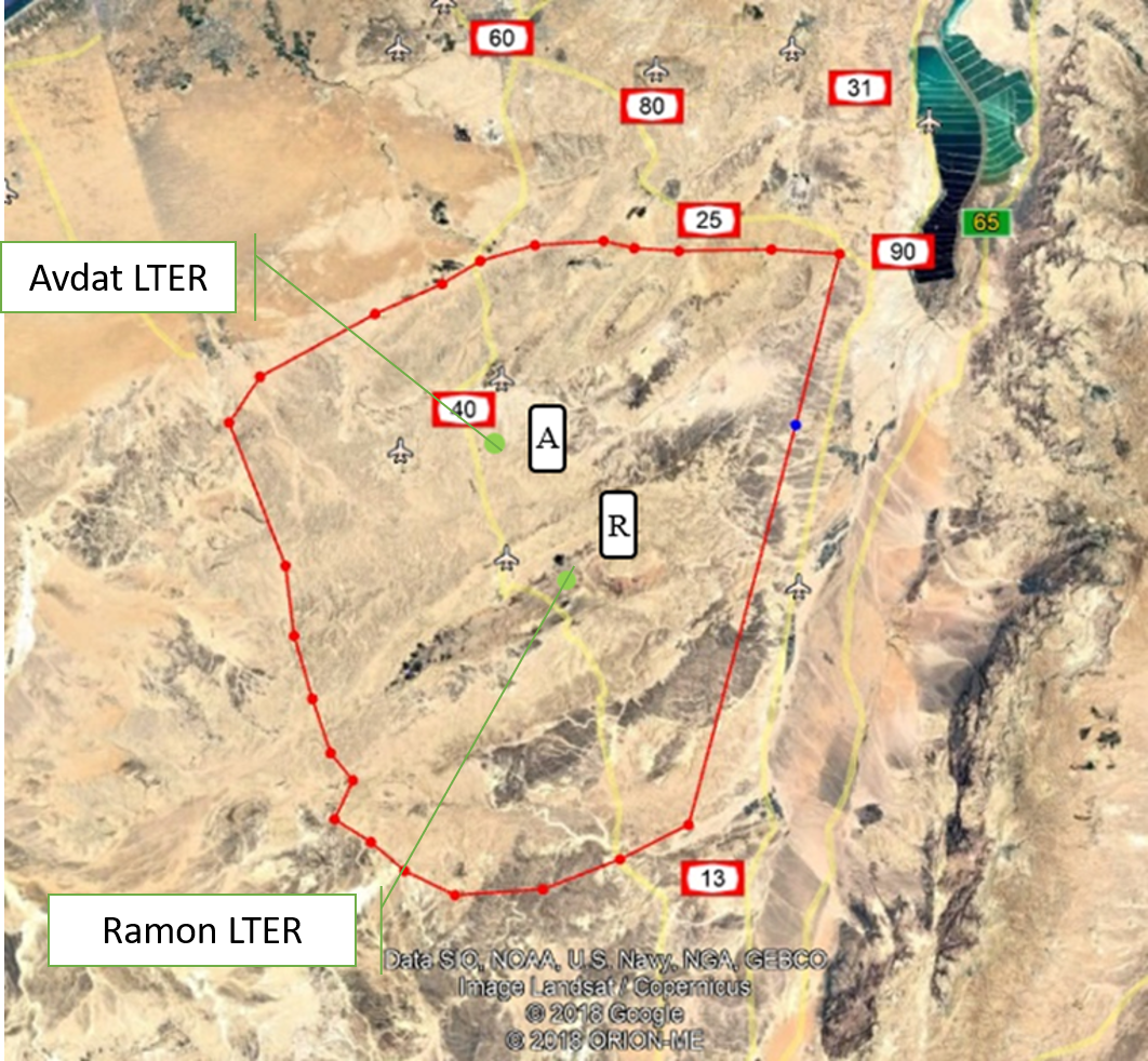
The Negev Highlands (NH) LTSER platform is situated between the Sinai Peninsula to the west and the Arava – Dead Sea depression to the east. This is a rocky terrain, covering an area of 17,000 sq. km with series of ridges at an altitude of 400-1000 m above sea level. As part of the Saharo-Arabian desert belt, the climate across the NH is arid to hyper-arid region: January’s mean daily temperature is 10 °C and July’s mean daily temperature is 25 °C The potential evaporation is approximately 2200 mm/y, and mean annual precipitation is 70–130 mm, with large inter annual variations. The rainy season occurs during the winter months, from November to March. The area is rich with unique natural landscapes. One of the most prominent of these are the Makhteshim, which is the largest erosion craters in the world. In addition to its unique landscapes, it is also a habitat for various species of flora and fauna that are adapted to arid zones and highlands, some of which are endemic to the area. The Negev Highland LTSER platform includes two LTER sites: Avdat Site in the arid zone and Makhtesh Ramon site in the hyper arid zone. Archaeological remains indicate that humans lived in the area for at least 1.4 million years. Today, about 10,000 residents live here, in towns, agricultural communities, small Bedouin tribal villages and tourist-agricultural farms. Most of it is concentrated along the main route (Route No. 40), while much of the area beyond the roads is either designated nature reserves or firing zones. The two main livelihoods in NH today are agriculture - mainly vines and olives, and tourism; Both are greatly affected by climate change. Agriculture relies on desalinated seawater imported into the area. However, it is affected by the climate in several ways: 1) flash floods cause increased soil erosion. 2) Long periods of drought during the winter, cause increased evaporation and therefore large water consumption. This is when the price of water is the main expense of the farmers, and increasing it may make agriculture unprofitable. 3) The uncertainty regarding the amount of precipitation and their timing, characterizes the arid environment. Recent climate changes are increasing this uncertainty and therefore make it very difficult for farmers to plan their land cultivation and expenses. Climatic uncertainty poses a significant challenge also for tourism operators; Jews and Bedouins, as well. This is due to the multiplicity of events of extreme climatic conditions (extreme cold or extreme heat), which repel tourists from reaching the area. And, a multitude of years when there is not enough precipitation to generate the famous spring bloom of the area. For the past 7 years, the NH LTSER's researchers have been working closely with three stakeholder groups in the area: winegrowers in the valleys, the Negev Highlands Tourism Association and Bedouin tourism operators. In Green Transformation we will actively engage with this group, through tow case studies: 1) The Desert Miracle farm - which will serve as a monitoring and dissemination knowledge farm; In a collaboration with the owner of the farm, R and D agriculture in the NH and the Center for Flood Research (DSASC). 2) Tourism in the NH; In collaboration with the NH Tourism Association. Through joint work with these NGOs, we will develop a long-term monitoring program and educational materials. The topics we will deal with: reducing soil erosion and increasing soil moisture, by using appropriate agricultural methods to multiply flash floods, which will be distributed to additional farmers in the area through activities at the monitoring farm. and to tourists through workshops of the Tourism Association. In the case of tourists, the aspect to be monitored is the number of tourists who come to the area in relation to the weather conditions. Together with the Tourist Association we will develop tourist-monitoring system. The high sensitivity of the arid region to climate change and the great exposure of the impact of these changes on animals, plants and humans, invite possible tourist-educational activities aimed at transformation in ways of thinking and behaving. An environmental education program and educational tools will be developed together with the Tourist Association. Their impact will be monitored in collaboration between the NH LTSER platforms researchers and tourism operators.
-
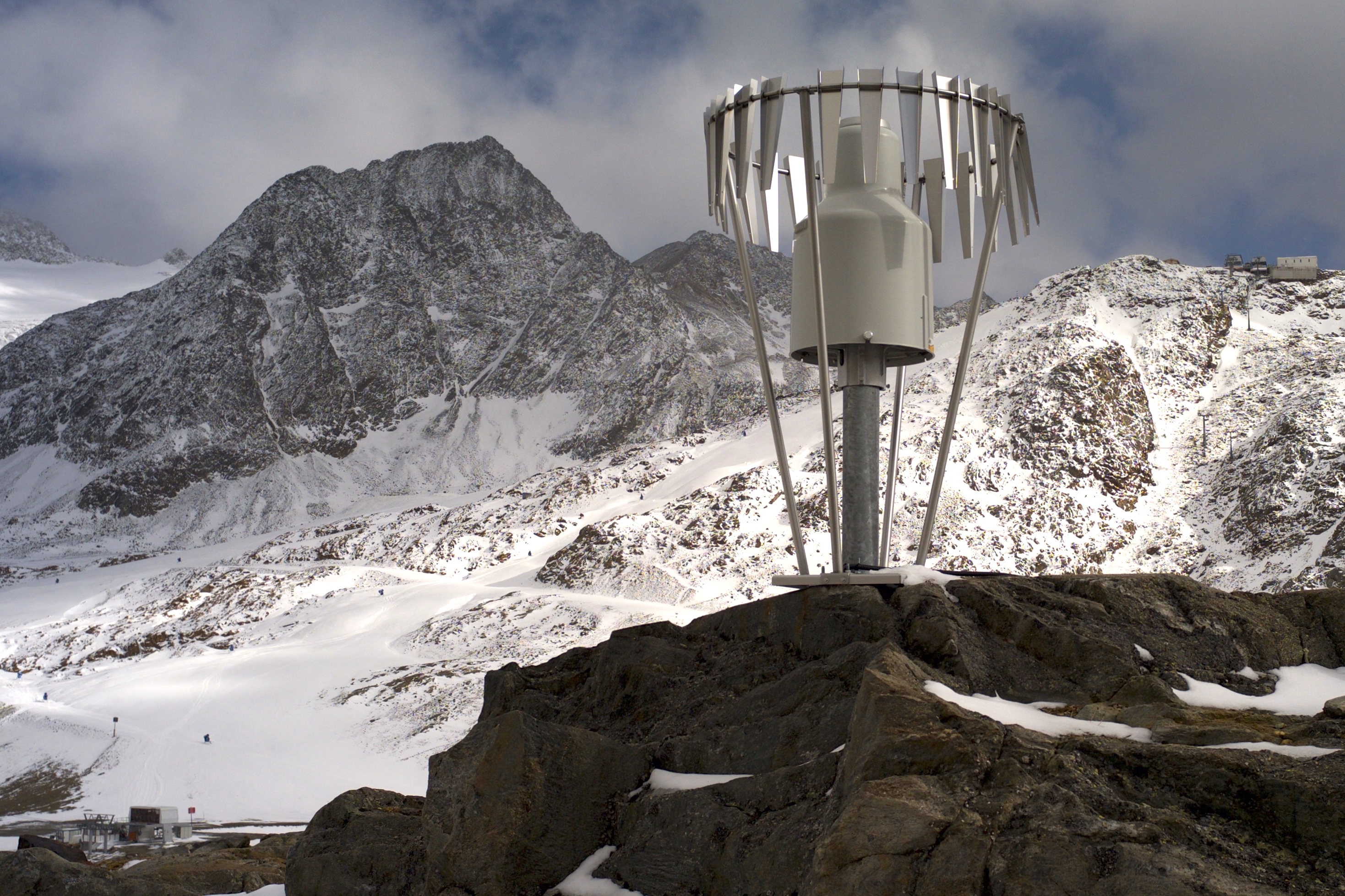
The Mullwitzkees is located in the Venediger Group in the core zone of the National Park Hohe Tauern. The upper part of the glacier (outer Mullwitzkees) is oriented to the south.The lower part of the glacier, especially the tongue, is oriented to West-South-West.
-
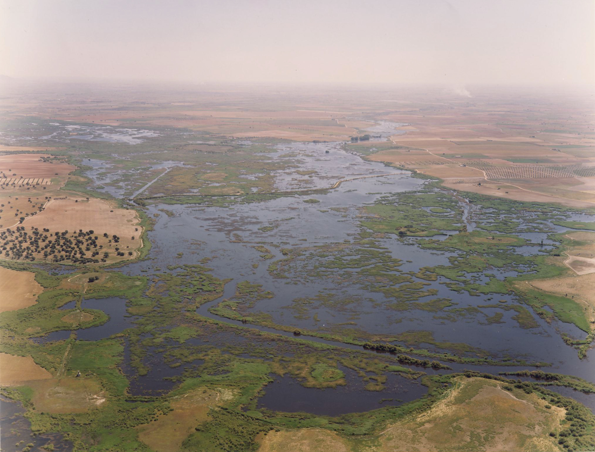
Las Tablas de Daimiel National Park (TDNP) is a floodplain wetland located at Central Spain in the core of La Mancha Húmeda Biosphere Reserve. Until the 1970s, wetland inundation was due to natural flooding of both the Gigüela and the Guadiana Rivers, and to the aquifer discharge (Llanura Manchega Occidental aquifer) as the groundwater table was close to the surface. Historically, the wetland´s inundation was also promoted by small water-mill dams which helped to increase the water-level. TDNP is the typical example of wetland degradation in the Mediterranean Europe, including dessication, agriculture conversion, groundwater overexplotitation and water quality impairing. Most importantly, aquifer overexploitation resulting from excessive agricultural irrigation strongly changed the ecosystem hydrology from a semi-permanent wetland to a highly fluctuating ecosystem with long periods (several years) of almost complete dryness. From the 1870s until the 1950s, the area was a private hunting park. It then became a National Hunting Reserve and later, in 1973, a National Park. It was included in the Ramsar convention in 1982. Its main environmental values are the large waterfowl populations, the European cut-sedge and the reed, and the plasticity of the ecosystem to absorb different threats.
-
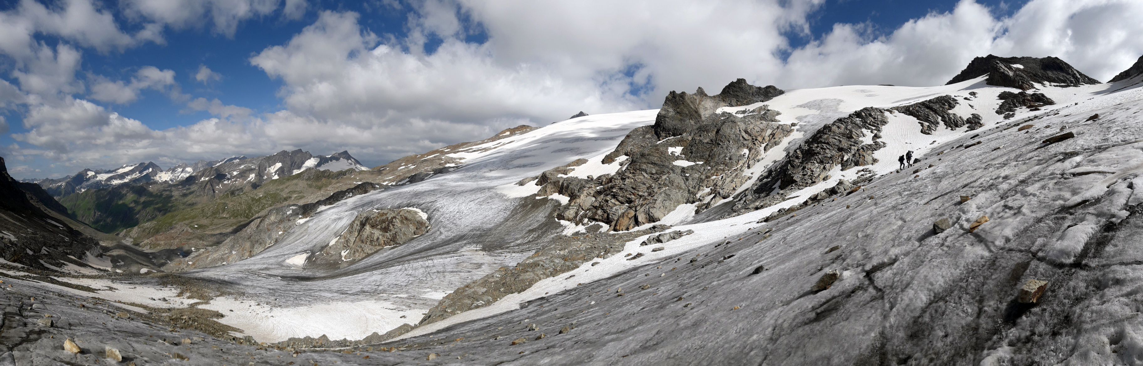
In the Rofental (Ötztal Alps) a consortium of the three institutions, and open to research partners worldwide, concentrates on studying and monitoring cryospheric, atmospheric and hydrological processes and changes with particular attention to the complex topography and climate settings of the Alpine terrain. First documents from glaciers in the Rofental, Ötztal Alps, date back as far as 1601 and regular observations and systematic studies had begun more than 150 years ago. First geodetic maps where generated in the late 19th century, first rain gauges were mounted in 1929 and glacier mass balance time series of Hintereis-, Vernagt- and Kesselwandferner are among the longest uninterrupted world-wide, building a basis for regional hydrological studies, for glacier-climate and ice dynamic research, and for estimating the world wide glacier’s contribution to sea level rise. By 2014, networks of stakes and pits for mass balance monitoring are maintained at Hochjoch-, Hintereis-, Kesselwand- and Vernagtferner by the consortium members. Runoff gauges at Vernagtferner and in Vent (operated by the Hydrological Office of Tyrol) and a network of rain gauges in the Rofental basin are the basis for high mountain hydrological studies. A varying number of automatic weather stations on and in the surroundings of the glaciers are operated by the Rofental consortium. The glaciers in the Rofental are frequently used as a test site for process studies, model development and evaluations and for new remote sensing or ground based methods in glaciological research. A series of airborne LIDAR derived high resolution DTMs of Hintereisferner and its surroundings are available since 2001. They are subject of ongoing evaluations and method comparison studies as well as for monitoring and studying periglacial morphodynamics. The generated data are available from the consortium partners, glaciological key results are annually reported to the World Glacier Monitoring Service (WGMS). A research station on Hintereisferner (with observer status in the Horizon 2020 INTERACT network) and one at Vernagtbach serve as logistic bases for fieldwork. In recent studies, socio-ecological research aspects – e.g. in relation with the use of water for energy production and tourism – comprise the natural scientific investigations.
-
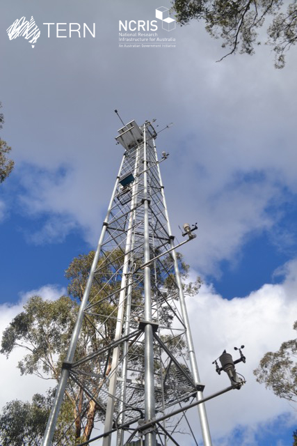
The Victorian Dry Eucalypt SuperSite is a member of the Australian SuperSite Network (SuperSites, http://www.supersites.net.au/), a facility within the Australian Terrestrial Ecosystem Network (TERN, http://www.tern.org.au/) and has two nodes (Whroo and Wombat). The Victorian Dry Eucalypt SuperSite - Whroo site near Shepparton was established in 2011. The vegetation is dominated by two main Eucalypt species: Eucalyptus microcarpa (Grey Box) and Eucalyptus leucoxylon (Yellow Gum). Smaller numbers of Eucalyptus sideroxylon (Ironbark) and Acacia pycnantha (Golden Wattle) are also found on site. The surrounding area includes the Whroo Historical area, and Rushworth State containing remnant native vegetation. Key research objectives include: • What are the elements of structure, composition, functions and processes of the dry eucalypt forests of South Eastern Australia required for the sustainable management of these ecosystems? • What is the carbon sink/source strength of a dry sclerophyll forest and what is their contribution to Australia’s National Carbon Inventory? • What is the magnitude of emission and/or uptake of non-CO2 greenhouse gases, such as nitrous oxide and methane of dry eucalypt forest? • How will climate variability, drought or fire influence the ecosystem processes of dry eucalypt forest? . The site is on the lands of the Ngurai-illam-wurrung Aboriginal people.
-
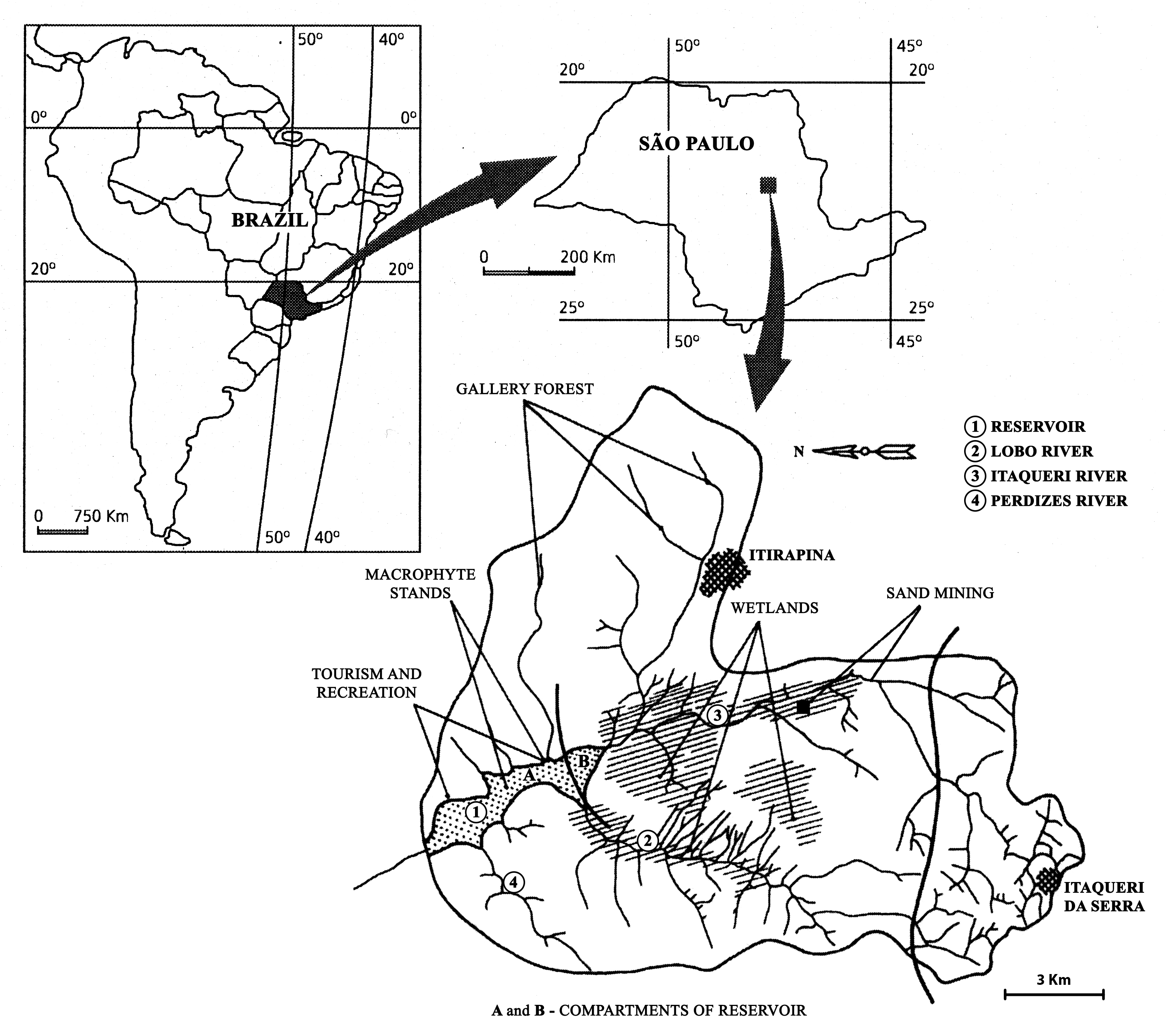
The watershed is located in the center of São Paulo State, Southeast of Brazil. The coordinates are: Lat. 22º 10' 08,5" S; Long. 47º 57' 11,7" W. The drainage density is 0.75km/km2. The maximum altitude is 800m. Basin declivity is 0.00575m/m. The local climate is characterised by alternating dry and wet periods, the wetter period falling in summer and autumn, and the winter and spring seasons being mainly dry. Annual precipitation is around 1500 mm per year. Temperatures are typically between 15 °C and 17 °C during the coldest winter month (July); in the warmest summer month (January), water temperatures between 21 °C to 23 °C are recorded. Potential evapotranspiration is between 500 mm to 1000 mm per year. According to the Koppen classification, the climate is described as ‘warm with a dry period’. The watershed is dominated by holocenic sandy sediments. In the lowland areas, hydromorphic and organic soils predominate. Soils derived from basalt intrusion occur in some areas of the watershed, as red soil hotspots. The natural vegetation is characteristically a savanna type, the Cerrado, typical of the continental regions of Brazil, consisting of bushes and trees adapted to a long (six months) dry season with periodic fires. Given the hydrogeochemical character of the watershed, the ionic strength and the nutrient content of the water of Lobo-Broa Reservoir are correspondingly low.
-

Tronchaney, Conca di Torgnon, (Torgnon, Aosta), + 388330 + 5075950; Aosta Valley