
direct radiation intensity
Type of resources
Available actions
Topics
Keywords
Contact for the resource
Provided by
Years
Formats
Representation types
-
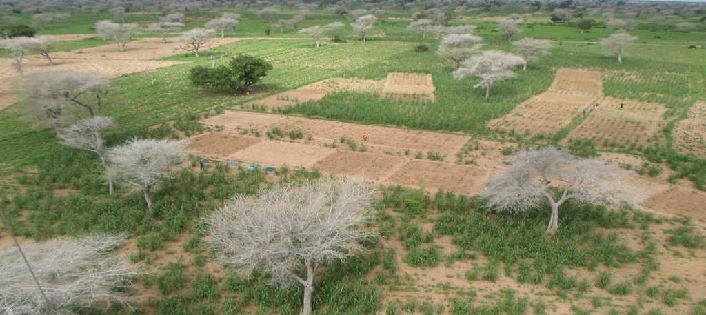
Niakhar is a complementary site of the AMMA-CATCH observation network, that has been set up to study the longitudinal gradient over West Africa in comlement to the mesoscale sites. It is located in central Senegal, under Sahelian climate in a rural area, 150 km from Dakar. The studies focus on meteo/vegetation interactions in a cultural complex. The AMMA-CATCH site is coupled with the "long-term Collaborative Observatory on agroforestry ecosystem services", managed by partners since 2018.
-
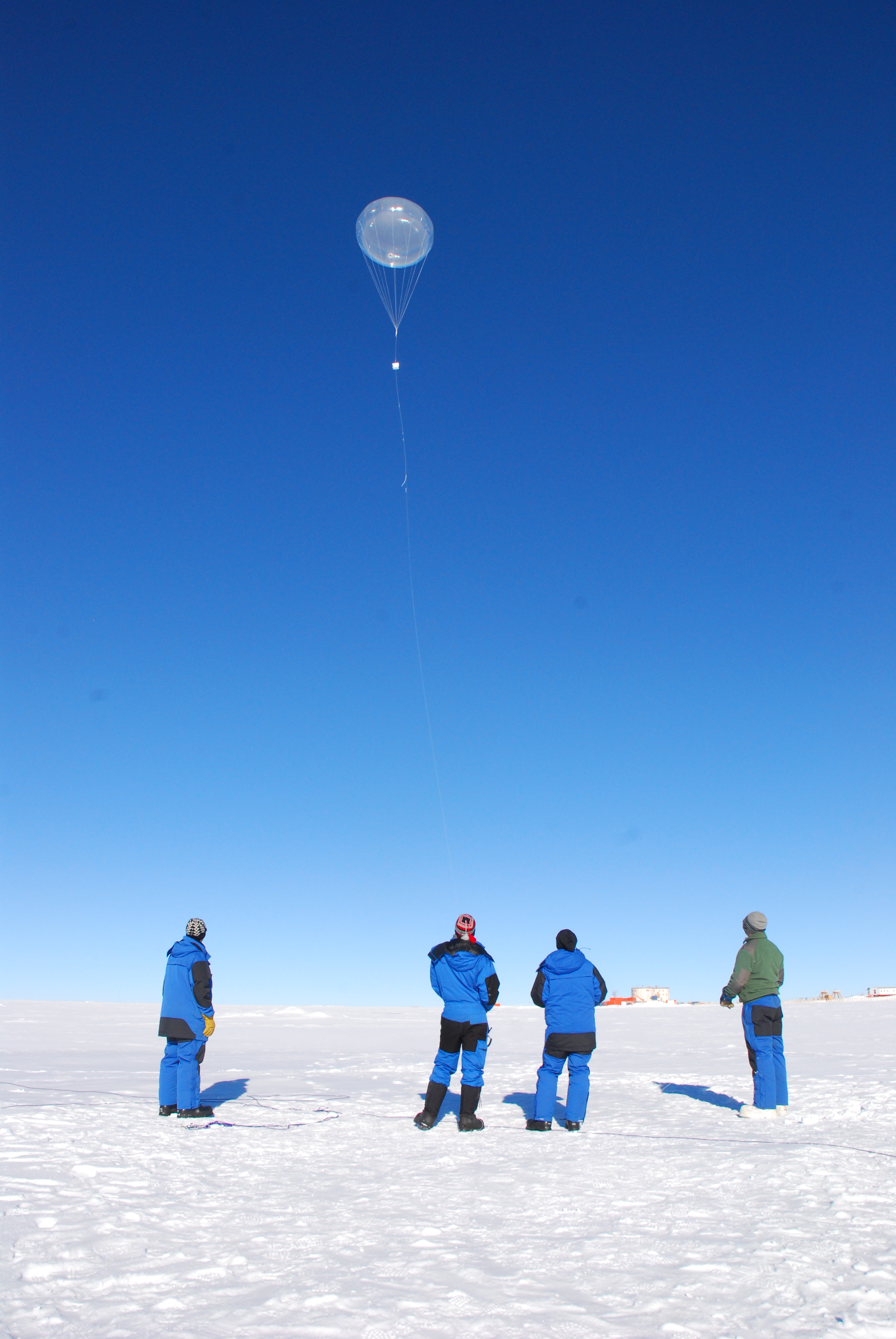
Concordia is a joint French-Italian research facility opened in 2005 on the Antarctic Plateau, Antarctica (-75.1, 123.33), managed together by PNRA (Italian National Antarctic Programme) and IPEV (Institut Polaire Francais Paul Emile Victor). It is built at 3,233 m above sea level on the third highest summit of Antarctica: Dome C.
-
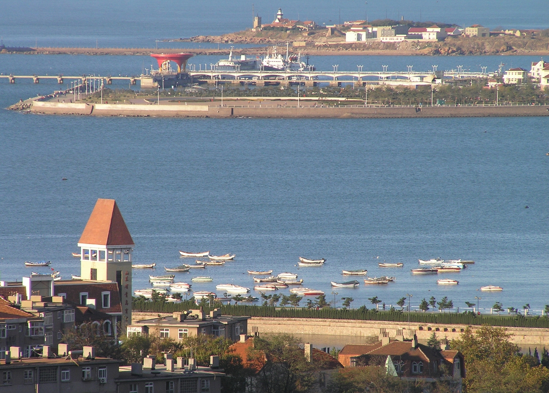
The Jiaozhou Bay, covering an area of 390 km2 between 3538′ and 3618′ N and 12004′ and 12023′ E, surrounded by the Qingdao city. As a semi-enclosed, fan-shaped bay, the narrowest place at the channel connecting with the Yellow Sea, from the Tuan Island to the Xuejia Island, is only 3000 m wide. Its average depth is 6-7 m, with most part of the bayshallower than 5 m, and the tidal zone adds up to 125 km2. The tide of Jiaozhou Bay is regular semidiurnal type. The speed of the flood is greater than that of the ebb, and the duration of the flood is shorter than that of the ebb. There are many peninsulas and islands in the bay, so the circulation inside is complicated. After the residual current analysis, six circulation systems were observed in Jiaozhou Bay. Marine biodiversity and productivity is high in the bay. With the development of Qingao City, the population is increasing quickly around Jiaozhou Bay. Farms, factories, highways, ports, tourism etc. can all affect the environments of the bay. Most of the land-sourced input are from several rivers, such as the Dagu, Haibo, Licun and Nan Jiaolai rivers.
-
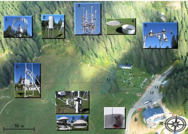
The Col de Porte pilot site is located near Grenoble, in the Chartreuse massif (elevation : 1325m, latitude : 45°30’N, longitude : 5°77’ E). At this mountain site located in a grassy meadow surrounded by a coniferous forest; all the measurements are located within an flat area of 50 × 50 m. Meteorological and snow parameters are recorded hourly since 1961. These parameters are : - Air temperature and relative humidity of air - Incoming and outcoming short and long-wave radiations - Wind speed and direction - Precipitation - Snow depth, snow water equivalent - Settlements and snow temperatures of the different layers of the snowpack Weekly snowpack profiles are also carried out, including major stratigraphic properties of snow (temperature, density, liquid water content, snow type). All sensors are located within a radius of a few tens of meters. (1) Geonor precipitation gauges (3 sensors) and OTT2 (1 sensor), (2) PG2000 heated and non-heated precipitation gauges, (3) windspeed measurements at the top of the 10 m meteorological mast and at the same level of the precipitation gauges, (4) lysimeters (2 sensors), (5) snow depth and surface temperature sensors and settling disks, (6) temperature and relative humidity of air sensors placed in the shelter, (7) Incoming and outcoming longwave and shortwave radiation sensors placed on the rotating arm, (8) close-up on the 4 components radiation sensors, (9) building (cold room, data acquisition, lab space), (10) cosmic rays counter for SWE measurements, (11) former experimental area for the study of road/snow interactions, (12) automatic snow and weather station Nivose for testing purposes (generally used in remote mountain areas), (13) forest area impacted by the cut in 1999, (14) snow pit area, Fore more information refer to : Morin, S., Lejeune, Y., Lesaffre, B., Panel, J.-M., Poncet, D., David, P., and Sudul, M.: An 18-yr long (1993-2011) snow and meteorological dataset from a mid-altitude mountain site (Col de Porte, France, 1325 m alt.) for driving and evaluating snowpack models, Earth Syst. Sci. Data, 4, 13-21, doi:10.5194/essd-4-13-2012, 2012
-
Processing of time series of satellite and airborne images, with different spatial and spectral resolution, in order to derive water quality maps based on physically based algorithms parametrised with specific optical properties of lake Garda. Generation of spatial and temporal information of different water quality parameters of surface water column and coastal zone. Dedicated actives of calibration and validation of satellite images, algorithms and products.
-
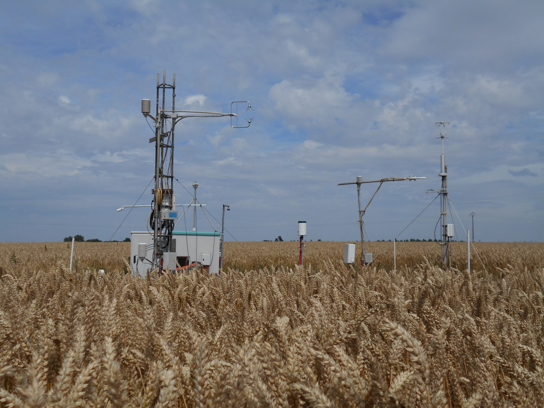
The site is a cropland with a 4-year rotation. Fluxes of CO2 and water vapour are measured by an eddy covariance system. Research activities are carried out by the university of Liège (GxABT).
-
It is located in the region of the Grand Causses, south of the Massif Central. The karstic aquifer of Durzon represents a surface of 100 km² which feeds the spring of Durzon. This spring supplies the drinking water of the Aveyron part of Larzac. The observatory has a set of sites dedicated to gravimetric, inclinometric and hydro-geodesic observations, as well as a flow tower for evapotranspiration measurements.
-
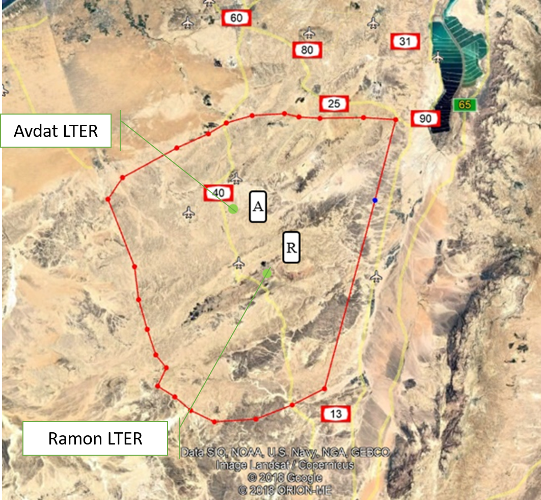
The Negev Highlands (NH) LTSER platform is situated between the Sinai Peninsula to the west and the Arava – Dead Sea depression to the east. This is a rocky terrain, covering an area of 17,000 sq. km with series of ridges at an altitude of 400-1000 m above sea level. As part of the Saharo-Arabian desert belt, the climate across the NH is arid to hyper-arid region: January’s mean daily temperature is 10 °C and July’s mean daily temperature is 25 °C The potential evaporation is approximately 2200 mm/y, and mean annual precipitation is 70–130 mm, with large inter annual variations. The rainy season occurs during the winter months, from November to March. The area is rich with unique natural landscapes. One of the most prominent of these are the Makhteshim, which is the largest erosion craters in the world. In addition to its unique landscapes, it is also a habitat for various species of flora and fauna that are adapted to arid zones and highlands, some of which are endemic to the area. The Negev Highland LTSER platform includes two LTER sites: Avdat Site in the arid zone and Makhtesh Ramon site in the hyper arid zone. Archaeological remains indicate that humans lived in the area for at least 1.4 million years. Today, about 10,000 residents live here, in towns, agricultural communities, small Bedouin tribal villages and tourist-agricultural farms. Most of it is concentrated along the main route (Route No. 40), while much of the area beyond the roads is either designated nature reserves or firing zones. The two main livelihoods in NH today are agriculture - mainly vines and olives, and tourism; Both are greatly affected by climate change. Agriculture relies on desalinated seawater imported into the area. However, it is affected by the climate in several ways: 1) flash floods cause increased soil erosion. 2) Long periods of drought during the winter, cause increased evaporation and therefore large water consumption. This is when the price of water is the main expense of the farmers, and increasing it may make agriculture unprofitable. 3) The uncertainty regarding the amount of precipitation and their timing, characterizes the arid environment. Recent climate changes are increasing this uncertainty and therefore make it very difficult for farmers to plan their land cultivation and expenses. Climatic uncertainty poses a significant challenge also for tourism operators; Jews and Bedouins, as well. This is due to the multiplicity of events of extreme climatic conditions (extreme cold or extreme heat), which repel tourists from reaching the area. And, a multitude of years when there is not enough precipitation to generate the famous spring bloom of the area. For the past 7 years, the NH LTSER's researchers have been working closely with three stakeholder groups in the area: winegrowers in the valleys, the Negev Highlands Tourism Association and Bedouin tourism operators. In Green Transformation we will actively engage with this group, through tow case studies: 1) The Desert Miracle farm - which will serve as a monitoring and dissemination knowledge farm; In a collaboration with the owner of the farm, R and D agriculture in the NH and the Center for Flood Research (DSASC). 2) Tourism in the NH; In collaboration with the NH Tourism Association. Through joint work with these NGOs, we will develop a long-term monitoring program and educational materials. The topics we will deal with: reducing soil erosion and increasing soil moisture, by using appropriate agricultural methods to multiply flash floods, which will be distributed to additional farmers in the area through activities at the monitoring farm. and to tourists through workshops of the Tourism Association. In the case of tourists, the aspect to be monitored is the number of tourists who come to the area in relation to the weather conditions. Together with the Tourist Association we will develop tourist-monitoring system. The high sensitivity of the arid region to climate change and the great exposure of the impact of these changes on animals, plants and humans, invite possible tourist-educational activities aimed at transformation in ways of thinking and behaving. An environmental education program and educational tools will be developed together with the Tourist Association. Their impact will be monitored in collaboration between the NH LTSER platforms researchers and tourism operators.
-
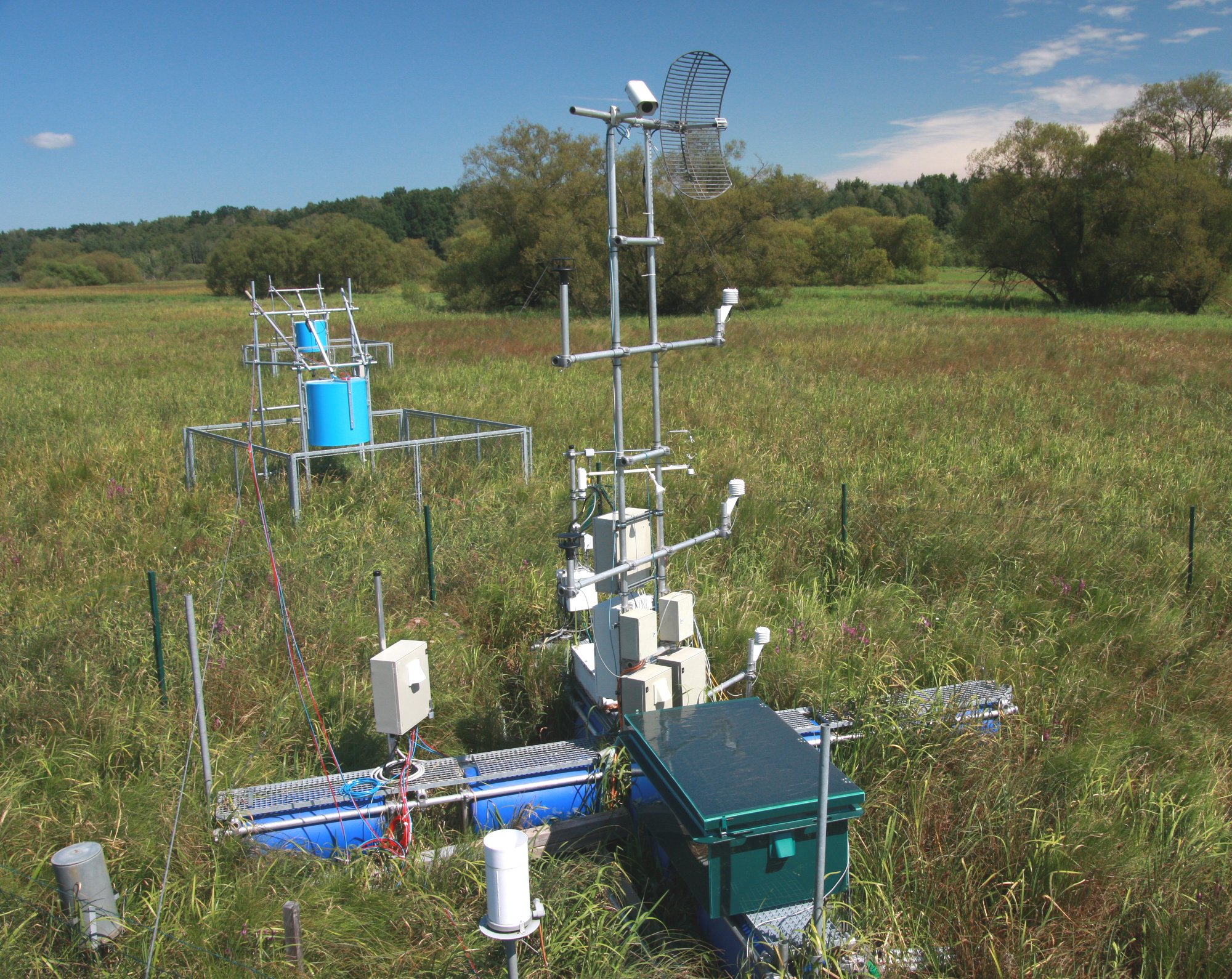
The Třeboň Wet Meadows is an LTER site of a 1 hectare area. It is a part of a wetland with the total area of 450 hectares situated in the inundation area of a large human-made reservoir (Rožmberk fishpond, 5 km2). The Wet Meadows are a predominantly herbaceous wetland with an up to several meters thick layer of organic sediment, which is superimposed on quaternary alluvial sands and clays. The vegetation cover is formed mainly by tall sedges (Carex acuta, C. vesicaria) and reed Canarygrass (Phalaris arundinacea). During the last 50 years, after cessation of mowing, a distinct stand structure of hummocks and hollows has developed. The hummocks are formed by tussocks of Carex acuta. On the site, wide water level fluctuations are recorded in some years. The relatively regular spring floods and irregular summer floods occur as a consequence of snow melting and summer rains in the catchment area, respectively. Extreme floods occurred in the summer of 2002 and both spring and summer of 2006, when the water level culminated at 2 m above the soil surface. The most frequently recorded position of the water level is at about −0.1 m. From 1977 to 2006, meteorological measurements were executed in a meteorological screen. Starting from 2006, the measurements have been executed with electronic sensors connected to data-loggers. Since that time, the site has been equipped for measuring carbon exchange and fluxes of CO2 and H2O (eddy covariance system, Licor). Since the spring of 2011, the site has been equipped for measuring methane and CO2 emissions from the sedges (automatic static flow chamber with a laser gas analyzer, LGR).The Wet Meadows are included in the integrated carbon observation system (ICOS) as a wetland ecosystem station.
-
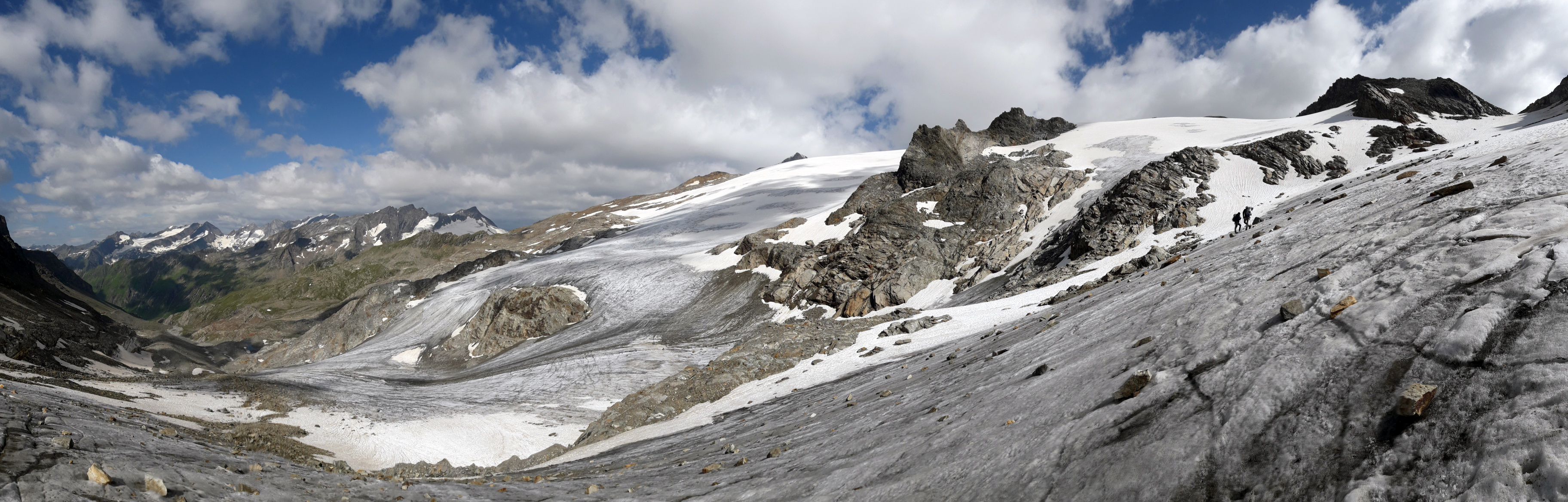
The Mullwitzkees is located in the Venediger Group in the core zone of the National Park Hohe Tauern. The upper part of the glacier (outer Mullwitzkees) is oriented to the south.The lower part of the glacier, especially the tongue, is oriented to West-South-West.