
dissolved organic nitrogen
Type of resources
Available actions
Topics
Keywords
Contact for the resource
Provided by
Years
Formats
Representation types
-
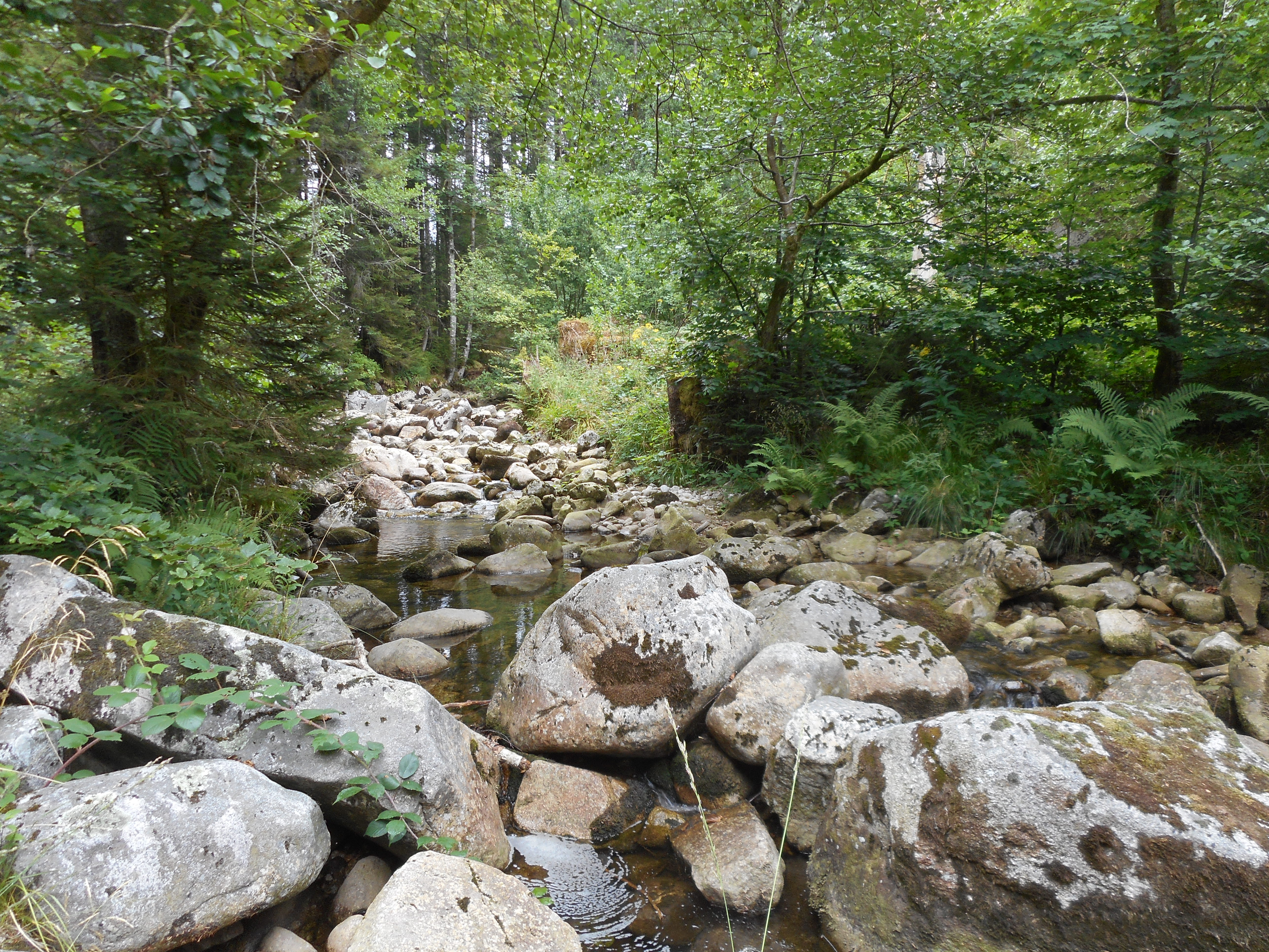
The observatory consists of 16 headstreams (15 in the Moselle River watershed, 1 in the Rhône River watershed), draining forest (mixed coniferous, beech) watersheds on sandstone and granites at very different altitudes.
-
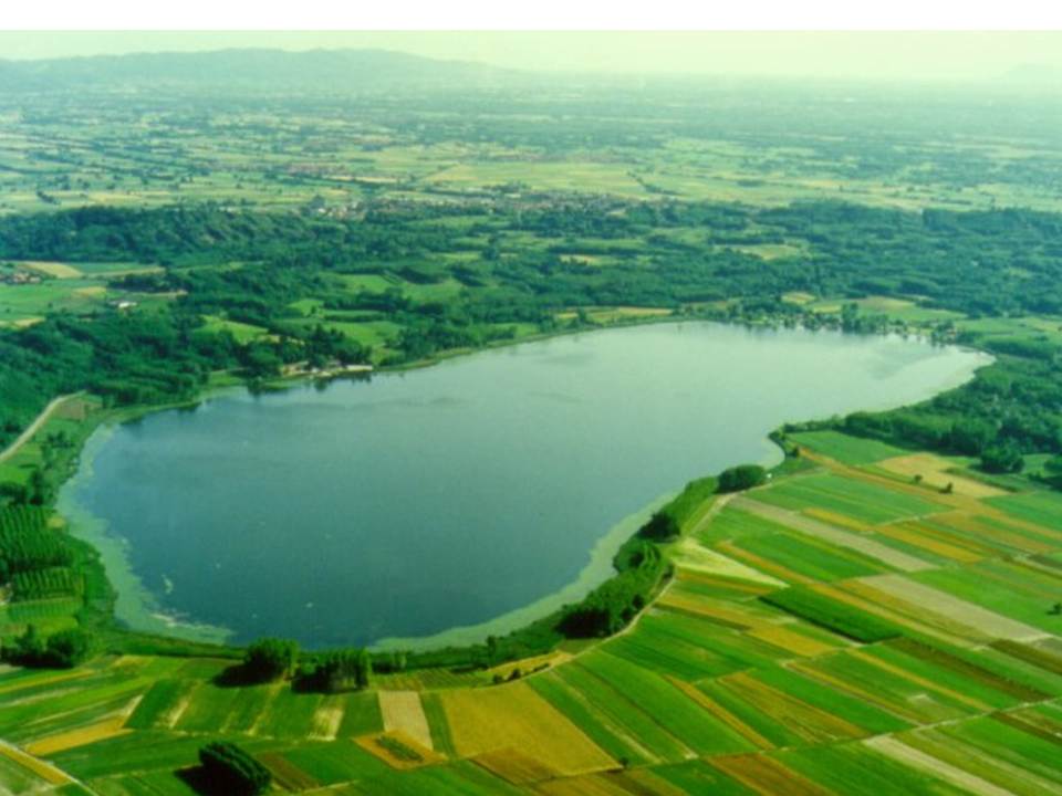
Lake Candia is a small and shallow lake, located in North-Westerm Italy. The mean elevation is 226 m a.s.l., the surface is 1,5 km², the max depth 7,7 m, the mean depth 4,7 m and the volume 0,007 km3. Lake Candia has suffered during its evolution a natural increase of its trophic state, undergoing a process of eutrophication culminated with a marked worsening of his ecological quality since the '60s. In the late '70s and mid '80s, this ecosystem was affected by fish mortality episodes and by the enormous development of emerged and submerged aquatic macrophytes. The systematic scientific study of Lake Candia began in 1985, when the CNR of Verbania was asked to perform a limnological research with the aim to propose a possible restoration intervention. In addition to the control of pollution sources from the basin, environmentally sound technologies were applied to reduce the effects of eutrophication, such as biomanipulation of the aquatic food chain and macrophyte control and management.The experiment conducted in Lake Candia has shown that significant improvements can be achieved through the management of a specific key components of the biocenosis of the lake. Data collection activities on hydrochemistry, phytoplankton, zooplankton, fish fauna, macrophytes, as well as physical limnology, took place from 1986 until 2012. To date, only hydrometeorological data collection (precipitation, air temperature, wind, solar radiation and lake levels), started in 1987, is active. LTER specific topics are: Long-term analysis of changes in community functional diversity of phyto-and zooplankton. Evaluation of the lake ecosystem response to short and intense rainfall events, in relation to the increase of nutrients input through runoff.
-
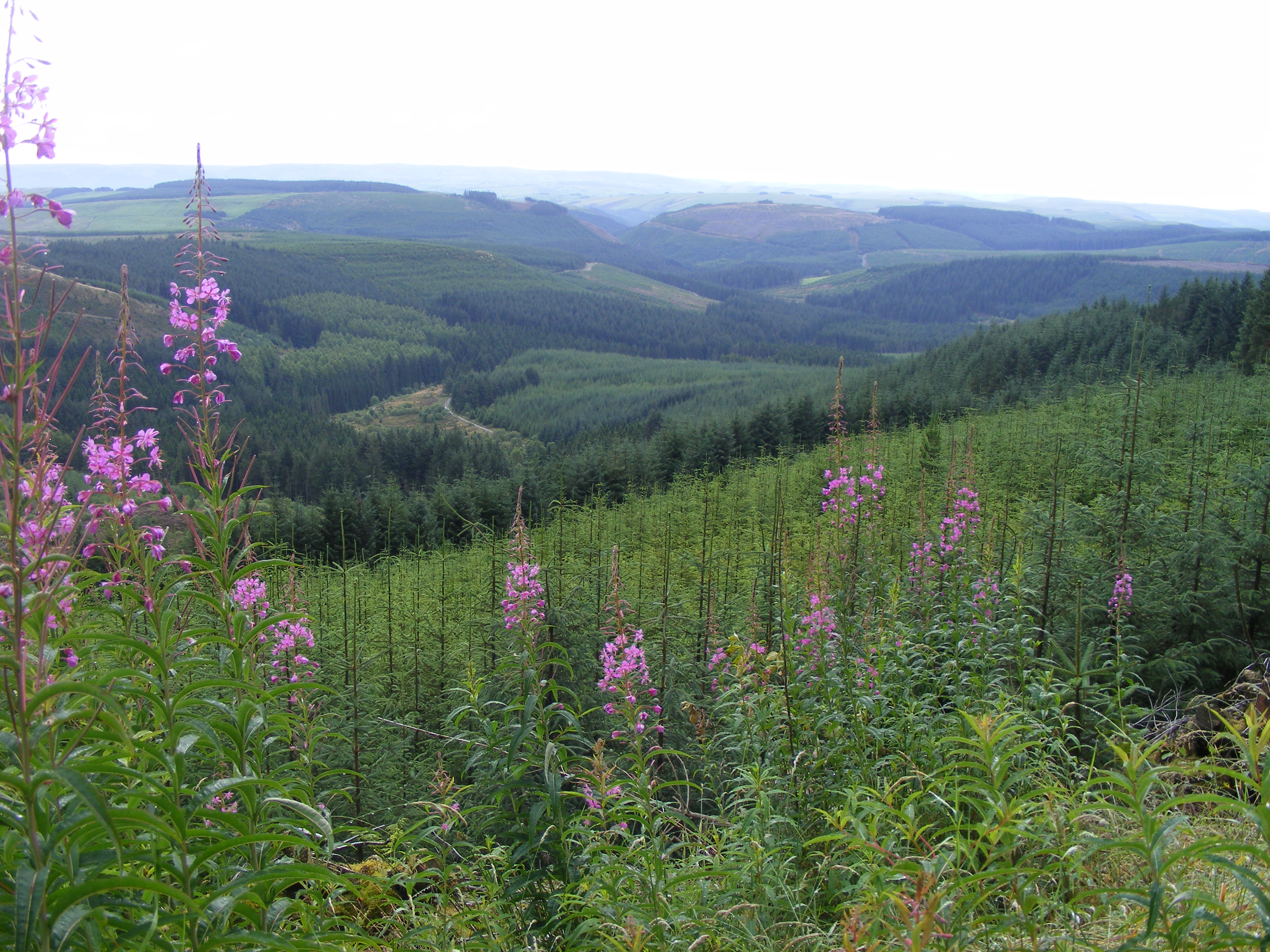
Plynlimon is at the headwaters of the Rivers Severn and Wye. The infrastructure at Plynlimon consists of 10 instrumented research catchments representing different land use options on the same geological parent material. It is the UK’s Critical Zone Observatory, part of the EU and global network of CZOs and is an ExpeER site. The infrastructure records high temporal resolution river flow and meteorological data (40 year data record) and stream water and precipitation chemistry for cations, anions, trace metals, nutrients, pH and alkalinity (30 year data record) and some data for suspended sediment. The site has an extensive spatial data library including topography, digital terrain model (DTM), soils, geology and vegetation/land-use available, open access, through the Environmental Information Data Centre (https://catalogue.ceh.ac.uk/documents/91961a0f-3158-4d00-984d-91eb1e03e8bd). Sub sites in the catchments represent a range of upland management types: mature/clear cut/replanted conifer forest; acid grassland; eroding peatland; improved grassland.Samples analysed for a wide range of major, minor and trace components. Bulk precipitation and cloudwater chemistry is also measured at one location.
-
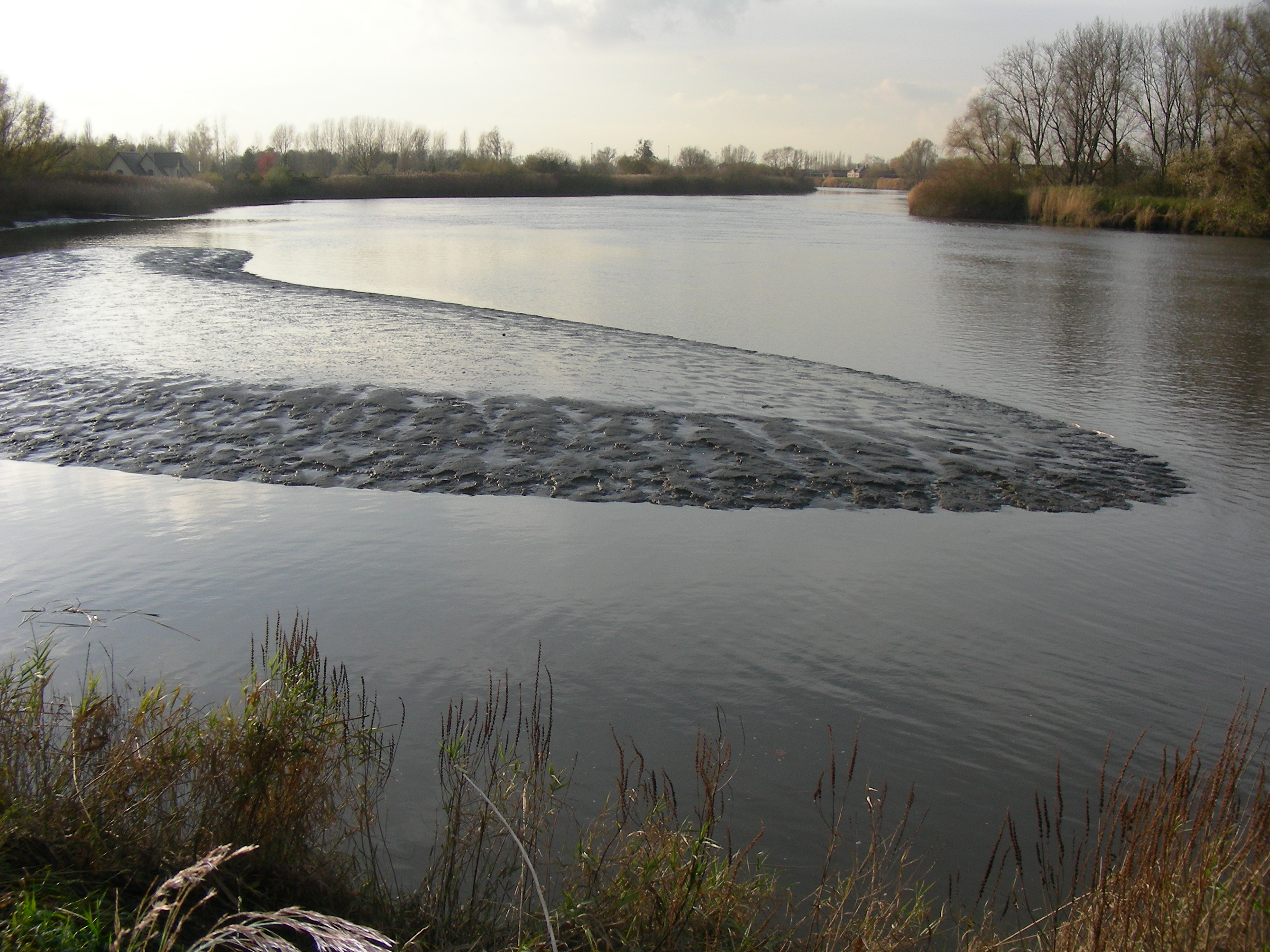
The study site starts at the mouth of the river (Vlissingen, the Netherlands) and extends to Gent, 160 km from the mouth, where tidal influence is stopped by sluices. The tributaries the Durme and the Rupel, with the Nete , Dijle and Zenne are also under tidal influence and are considered part of the estuary. The natural inundated areas around the river and the valleys up to 5m TAW are also part of the study system.
-
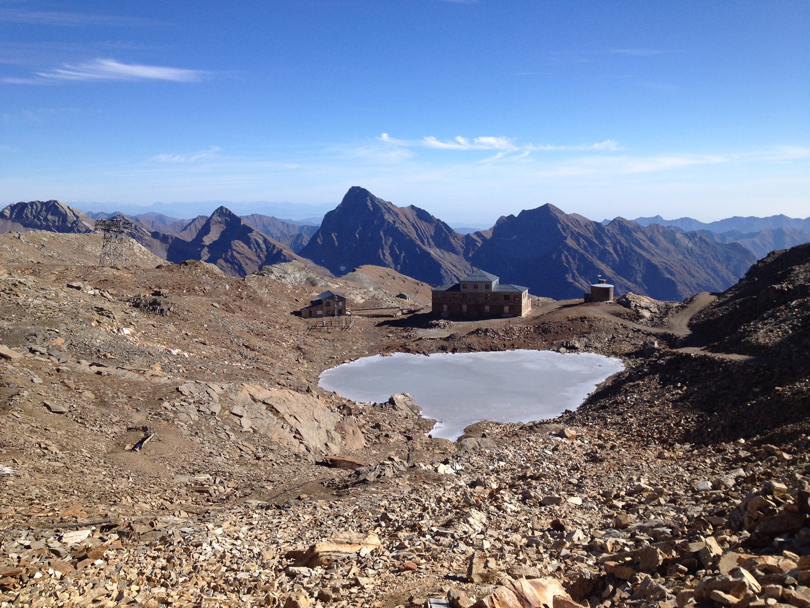
The "Istituto Scientifico Angelo Mosso" research site is located on the watershed between Piedmont and Valle d'Aosta (NW-Italy), in the Municipality of Alagna Valsesia (Monte Rosa massif). The Scientific Laboratories of the "Angelo Mosso Institute" at Col d’Olen (2901 m a.s.l.), the heart of this research site, were built between 1905 and 1907, when it became clear that the Capanna Regina Margherita on Monte Rosa (4554 m a.s.l.), as a high-elevation research centre, had become insufficient to the increasing number of requests for use by the international scientific community. From here the idea promoted by Angelo Mosso (1846-1910), professor of human physiology at the University of Turin, to add an additional structure to the Observatory of the Capanna Regina Margherita for make larger laboratories available to researchers and allow study stays at high elevation. This project soon became a reality thanks to the intervention of Queen Regina Margherita, Ministries of Education and Agriculture, the Italian Alpine Club and various personalities of the time. The research conducted at the Institute did not concern only human physiology, but also other disciplines, including alpine meteorology and glaciology, thanks also to the presence of the Meteorological Observatory that flanked the Institute, directed in the years 1925-40 by Umberto Monterin. It is now home to an automatic snow and weather station, managed by the Alpine Troops-Meteomont service. In addition to the University of Turin, the research groups that operate at the site and contribute to data collection and implementation are currently CNR-IRSA, Alpine Troops Command-Service Meteomont, Monterosa 2000 SpA and Monterosa SpA (Monterosa Ski), Protected areas of Valsesia, ARPA Piemonte, ARPA Valle d'Aosta and Sesia Val Grande Geopark. In addition to the valuable historical series of climate data, a series of research activities are devoted to the study of snow-soil-vegetation interactions, with particular reference to carbon dynamics e soil nitrogen (Magnani et al. 2017a,b; Freppaz et al. 2019). In addition, investigations are performed focusing on the chemical characteristics of high-elevation surface waters, fed by different cryospheric features such as rock glaciers, glaciers, and permafrost (Colombo et al. 2018a,b; 2019a,b; 2020; Vione et al., 2021). New research lines, aimed at investigating the most recent environmental challenges, have been added to the previous ones. For instance, investigations on sources and routes of atmospheric carbon and nitrogen species are ongoing. References: Colombo N. et al. (2018a), https://doi.org/10.1002/esp.4257. Colombo N. et al. (2018b), https://doi.org/10.1016/j.scitotenv.2018.05.098. Colombo N. et al. (2019a), https://doi.org/10.1016/j.scitotenv.2019.06.233. Colombo N. et al. (2019b), https://doi.org/10.1007/s00027-019-0670-z. Colombo N. et al. (2020), https://doi.org/10.1016/j.catena.2020.104700. Freppaz M. et al. (2019), https://doi.org/10.3897/natureconservation.34.30737. Magnani A. et al. (2017a), https://doi.org/10.1657/AAAR0016-037. Magnani A. et al. (2017b), https://doi.org/10.1016/j.catena.2017.03.007. Vione D. et al. (2021), https://doi.org/10.1016/j.scitotenv.2020.143464.
-
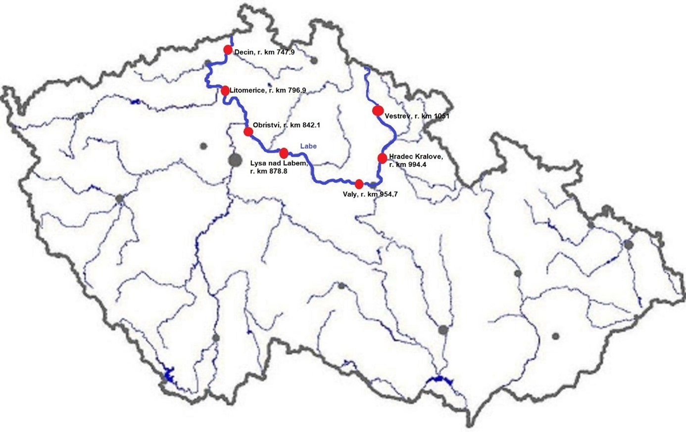
The Elbe River is one of the major rivers in Central Europe. It springs at an altitude of about 1,400 meters in the Giant Mountains in the north of the Czech Republic. It flows through eastern, middle, and northern Bohemia, and its catchment area includes most of Bohemia. The Elbe traverses the northeastern part of Germany and flows into the North Sea. The total river length is 1,094 km. In the Czech Republic, the monitored river length is 371 km and the catchment area includes 49,933 km2. The average flow at the Czech-German borders is 311 m3 s-1. Many weirs dam the watercourse of Elbe River in the Czech Republic. This artificial intervention is crucial for the characteristics of the riverbed, its width, depth, and bottom substrate. The width of the riverbed in the monitored area ranges from approx. 10 m on the upper course to approx. 150 m on the lower course and river sections above the weirs. The depth of the river varies from 0.5 m in the upper parts and below the weirs to more than 5 m in the lower course and above the weirs. The bottom substrate varies from the stony, gravelly, and sandy fractions in shallow and fast-running sections to muddy/silty fractions in slow-running sections above the weirs. The main tributaries of the Elbe in Bohemia are Metuje, Orlice, Jizera, Ploučnice, Vltava, Ohře and Bílina rivers. The catchment area is densely populated. The river is exposed to various sources of pollution (organic, agricultural, and industrial) and hydromorphological pressures (straightening, shortening, regulation of meanders, and fragmentation of river continuity). There are seven permanent monitoring sites on the Elbe River in the Czech Republic: Děčín (river kilometer 747.9), Litoměřice (796.9), Obříství (842.1), Lysá nad Labem (878.8), Valy (954.7), Hradec Králové (994.4) and Vestřev (1051). The Elbe basin long term environmental research has been organised by the Ministry of Environment of the Czech Republic and cooperation institutions since 1993. More than 600 physicochemical parameters, including sensory properties of water, are regularly monitored in at least nine different types of matrices (water, sediment, periphyton, floats, sedimentable floats, benthos, fish tissues, fish fry, and Dreissena polymorpha tissue) and using passive samplers. Among the main monitored characteristics belong balances of macroelements (carbon, nitrogen, oxygen, phosphorus), concentrations of inorganic salts, heavy metals and various organic pollutants such as pesticides, personal care products (including drugs) and other anthropogenic substances in the environment. Characteristics such as abundance and species composition are regularly monitored in fish, macrophytes, macrozoobenthos, phytobenthos and plankton.
-
Measurements of lake chemistry are part of lake monitoring, which is usually carried out by monthly sampling at many regular lake sites (5 to 17 sites depending on the intensity of the measurements over the years). The integrated sample represents the whole water column of this polymictic shallow lake with a mean lake depth of 1.2m. The measurement satisfy the analytical standards of Ö-Norm in Austria.
-
Lake Stechlin is a a deep clear-water lake located in a nature reserve approximately 80 km north of Berlin, Germany (53°10°N, 13°02° E), at 59 m elevation.The lake basin was formed during the last continental glaciation some 12,000 years ago and today is situated at the transition between temperate/maritime and temperate-continental climates.The drainage basin is almost completely covered by forest (95%), with the exception of the area of a former nuclear power plant and a small village, which diverts its wastewater into a different drainage basin. The shoreline of Lake Stechlin is largely undeveloped with no notable infrastructure. The seepage lake is essentially fed by precipitation and groundwater, resulting in a theoretical water retention time of greater than 40 years.
-
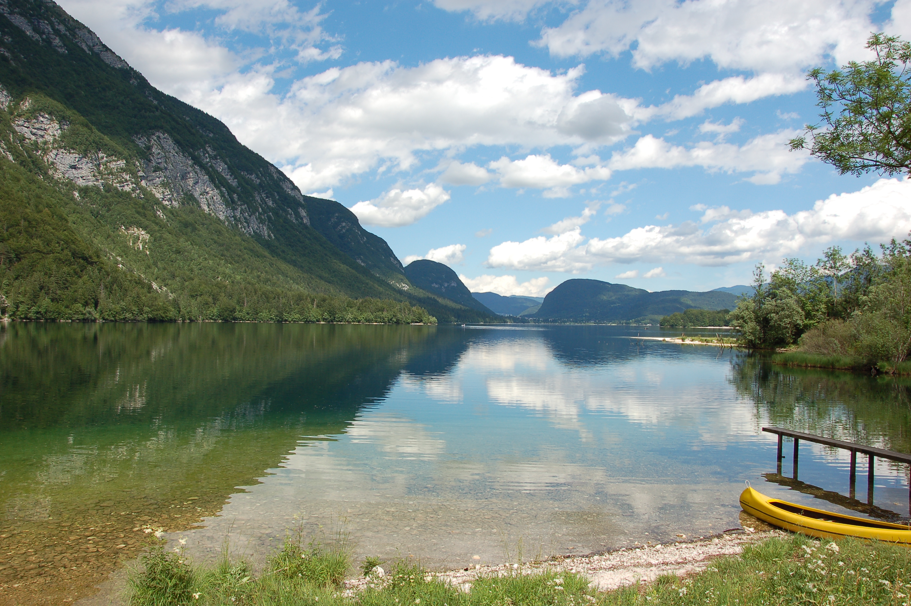
Lake Bohinj is of tectonic-glacial origin and was transformed by the Bohinj glacier. Its surface area is 3.28 km 2 , its volumeWeather conditions and chlorophyll concentrations determine long-term macrophyte community dynamics of Lake...92.5 × 10 6 m 3 and its maximum depth 45 m. It is located at an altitude of 525 m a.s.l. and issurrounded by mountains that are up to 2000 m high. Lake Bohinj is conditioned by the main inflow from River Savica and by several karst springs from the base of Mount Komarča and has a single outflow, River Sava Bohinjka. The residence time of the water in Lake Bohinj is about 4 months, which means that the total volume of the water in Lake Bohinj changes three times a year. The surrounding watershed comprises around 94.3 km2 and is mostly uninhabited, with a large portion extending above the tree line; therefore, the input of nutrients into Lake Bohinj is moderate. This watershed receives about 3300 mm of rainfall a year. Long-term temper-atures show a tendency to a rise. In winter, usually in January, the surface water cools and the lake can be frozen over. From 1961 to 1990, Lake Bohinj was frozen over for a mean of > 50 days/year, while in the decade from 1991 to 2000, the mean number of days with ice cover was reduced to 31 days/year. Since 1990, the lake did not freeze completely in individual years. The majority of the lake catchment area consists of carbon-ate rock, and therefore, the main lake sediment fraction is carbonate, while quartz and feldspar represent a minor part.
-
UK ECN Site. Esthwaite Water is a natural lake situated in a glacial valley and is generally agreed to be the most productive or eutrophic lake in the English Lake District. It lies approximately 65 m above sea level and has an area of 1 km2 and a maximum depth of 15.5 m. The average retention time is 90 days. The catchment area is 17.1 km 2 and the hills are composed geologically of Bannisdale slates and grits. The surrounding land is used chiefly for agricultural purposes and forestry. The lake is a grade 1 Site of Special Scientific Interest and has been a designated "Ramsar" site since November 1991. The diverse aquatic invertebrate fauna includes a number of species with restricted distributions in Britain, one of which is the flatworm, Bdellocephala punctata. The slender naiad, Najas flexilis, which is listed as Nationally Scarce, has been found in Esthwaite Tarn. Artificial enrichment of the lake occurs by input from the Hawkshead Sewage Treatment Works (which has operated a continuous programme of phosphate stripping since 1989) and originally from effluents from the fish farm which used to be situated towards the south of the lake. The lake undergoes summer stratification with oxygen depletion regularly below 7 m and sometimes as shallow as 5 m. The phytoplankton tends to be dominated by diatoms in spring and by cyanobacteria for much of the summer.