
dryland salinity
Type of resources
Available actions
Topics
Keywords
Contact for the resource
Provided by
Years
Formats
Representation types
-
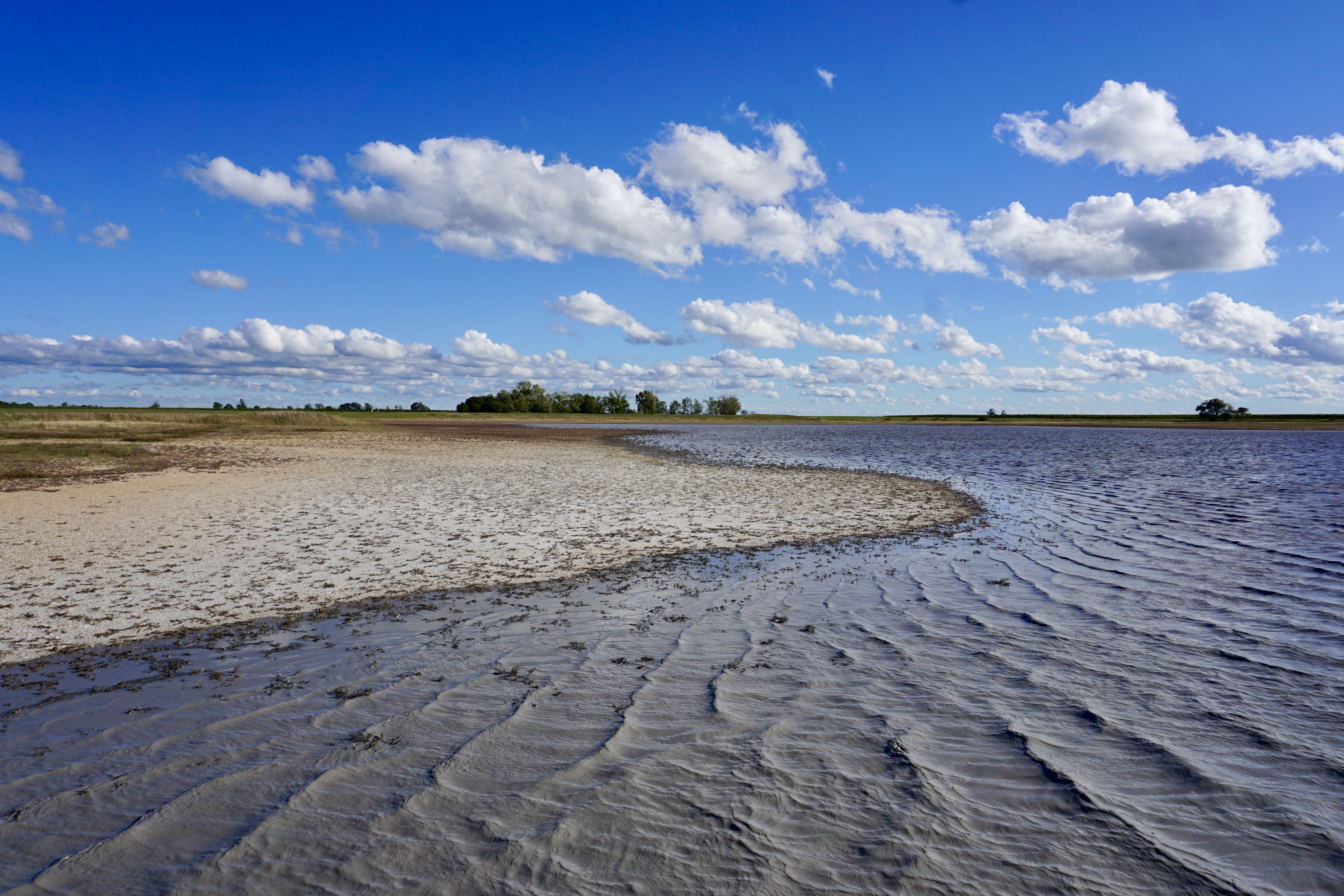
The Neusiedler See - Seewinkel National Park is the first cross-border National Park in Austria and the first Austrian National Park recognised by the IUCN. It covers in total about 90km² on Austrian territory. About 50% of the area (about 4500 ha) is a Nature Reserve Zone, which remains untouched by humans. This zone is dominated by the southernmost Austrian part of the reed belt from Lake Neusiedl. The Conservation Zones are mainly cultural landscapes and require landscape conservation measures and habitat management like pasturing, mowing, cutting reed or water retention. These measures are taken to preserve the cultural landscape and its biodiversity that has developed over centuries. Important habitats like 160 km² of reed belt and around 40 periodically dry soda lakes, as well as sand habitats, dry and wet meadows can be found closely associated with vineyards, cropland, touristic infrastructure and rural settlements. Long-term monitoring programs regarding bird populations, fish ecology or the grazing management enable the cross-border National Park Neusiedler See - Seewinkel to provide biological data from flora and fauna. Furthermore, all soda lakes are monitored frequently regarding salinity, oxygen, temperature, color etc. and biological parameters such as species diversity and quantity of macrozoobenthos. Due to the mosaique of protected and non-protected areas, the boundaries of the National Park area are difficult to define on the shown map.
-
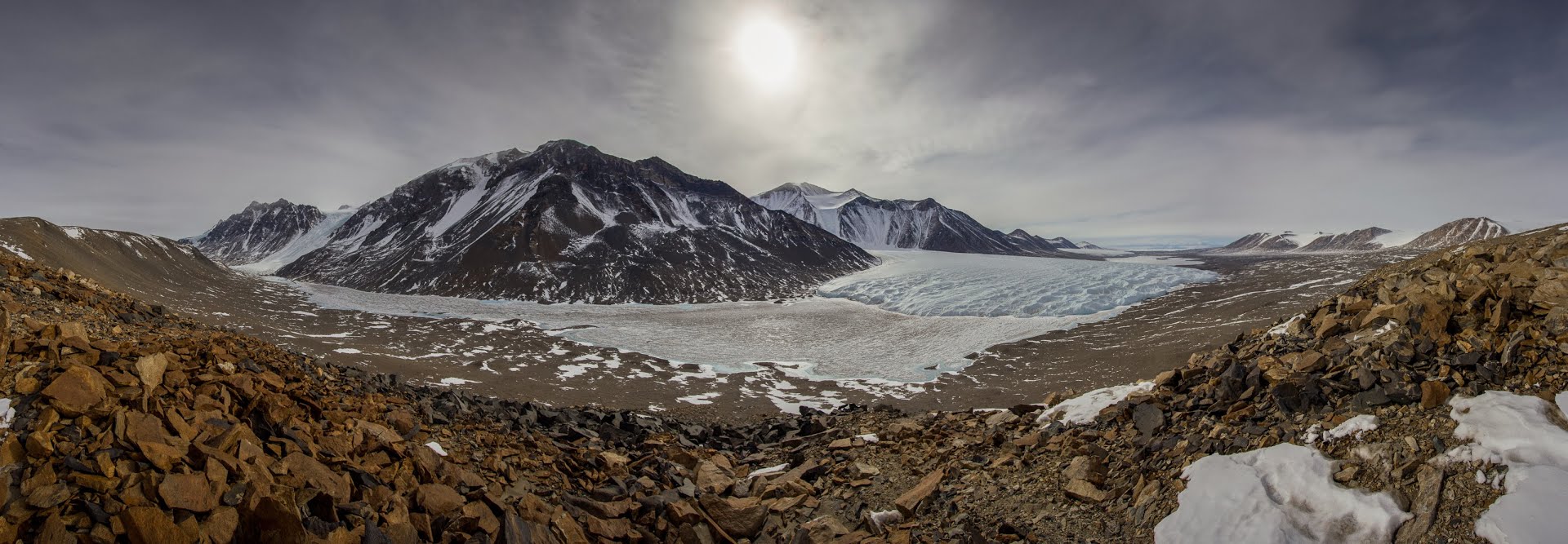
The McMurdo Dry Valleys (MDVs) (78°S, 162°E) represent the largest (4500 km^2) ice-free area on the Antarctic continent. The MDV landscape is a mosaic of glaciers, soil and exposed bedrock, and stream channels that connect glaciers to closed-basin, permanently ice-covered lakes on the valley floors. Mean annual air temperatures are cold (ranging from -15 to -30°C on the valley floors), and precipitation is low (~50 mm annual water equivalent as snow). Summer air temperatures typically hover around freezing and winter air temperatures are commonly < -40°C. While the water columns of the lakes are liquid and biologically active year round, glacial meltwater streams flow and soils thaw only during the austral summer. There are no vascular plants, but microbial mats are abundant in lakes and streams. Mat organisms are transported by wind onto glacier and lake ice surfaces where they actively metabolize in liquid water pockets (cryoconites) that form during the summer months. In the streams, which desiccate for ~10 months each year, cyanobacterial mats host extensive diatom and soil invertebrate communities. Lakes provide a habitat for diverse phototrophic and heterotrophic plankton communities that are adapted to annual light-dark cycles and temperatures near 0°C. Soils are inhabited by nematodes, rotifers, and tardigrades, all of which are metabolically active during summer. The McMurdo Dry Valleys LTER (MCM) began studying this cold desert ecosystem in 1993 and showed that its biocomplexity is inextricably linked to past and present climate drivers. In the fifth iteration of the MCM LTER program, we are working to determine how the MDVs respond to amplified landscape connectivity resulting from contemporary climate variation.
-
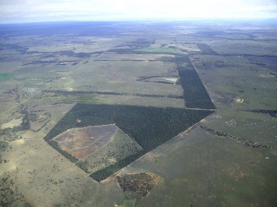
The aim of the Brigalow Catchment Study is to determine the effects of land clearing and land use change on hydrology, water quality, soil fertility and crop and animal productivity in the Brigalow Belt bioregion of central Queensland, Australia
-
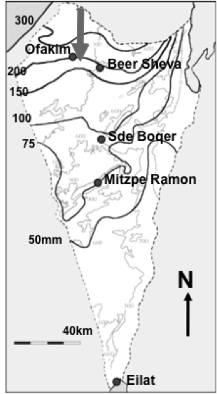
Designation: Ecosystem research and management under land-use and climate change. Climate: Mean annual precipitation 150-200mm between November and April; mean maximum summer temperature 34° C, mean minimum winter temperature 6° C. (Data avialable for 15-min interval meteorological measurements and daily summaries for rainfall, air and soil humidity and temperature, wind velocity and direction, from 1997 to the present.) Principal biomes: Semiarid shrub land (shrub-grass steppe), rocky and loessial watersheds, ephemeral streams. Vegetation is dominated by patch-forming dwarf shrubs (Noaea mucronata, Atractylis serratuloides and Thymelea hirsuta) with species-rich annual winter vegetation in the inter shrub (dominated by Stipa capensis and other grasses) and shrub patch understory (dominated by Anagallis arvensis and other forbs). As a result of drought there are also two new sub biomes: crust land and grass land. Management: Livestock grazing excluded in central watershed (20 ha) since 1987; restricted/controlled grazing by Bedouin sheep herds in surroundings; in the outer parts of the area native and exotic trees were planted in 1985-87 in contour dykes (‘shikhim’) on the slopes and in terraces in the riverbed. Research: 1. Long-term experiments (up to 20 years) for monitoring changes in abundance, diversity, species composition and distribution, and development of biological soil crusts (BSC), perennial plants (dwarf shrubs) and winter annuals in relation to rainfall, soil disturbance, patch distribution, and livestock grazing. 2. long term hydrological studies on rainfall-runoff relationship under natural and manipulation experiments. 3. Short-term experiments and surveys (1 to 5 years) A. for testing hypotheses about the detailed processes, mechanisms and interactions involved in the development, dynamics and stability of shrub- and BSC-dominated patches, their landscape mosaic patterns and their feed-back relationships with flows of materials through the landscape; B. for testing hypothesis on the effect of geodiversity on the stability of shrub land to extreme drought and understanding state changes in drylands. 4. Long term studies on cross scale-cross level interactions in natural and human modified landscape. 5. Network-related research including regional comparisons of herbaceous plant productivity in open rangeland along the Israeli North-South rainfall gradient, and global comparison of woody plant diversity effects on ecosystem functionality of most dryland regions of the world.
-

Historically, the role of the Galapagos Islands has been considered critical due to the evolutionary diversification induced by natural and historical isolation. The Galapagos National Park was established in 1959, based on its historical importance associated with Charles Darwin's voyage and its rare and endemic biodiversity, composed of unique vertebrate and plant communities (Rozzi et al. 2010). In 1978, the Galapagos Islands were declared a UNESCO World Heritage Site, a critical factor associated with this national park (Rozzi et al. 2010). The Galapagos Islands are a pristine area with local and regional climates influenced by the interaction of ocean currents and winds driven by the Inter-Tropical Convergence Zone; ITCZ (Conroy et al. 2008, Trueman and d'Ozouville 2010). The long-term programme includes forty natural aquatic ecosystems (lakes, ponds, lagoons and swamps) that will be sampled on the islands of San Cristobal, Santa Cruz, Isabela and Floreana, where possible along a lowland-highland gradient. The number of sampling points will vary according to environmental heterogeneity and the presence of a littoral region, among other factors.