
earth worms abundance
Type of resources
Available actions
Topics
Keywords
Contact for the resource
Provided by
Years
Formats
Representation types
-
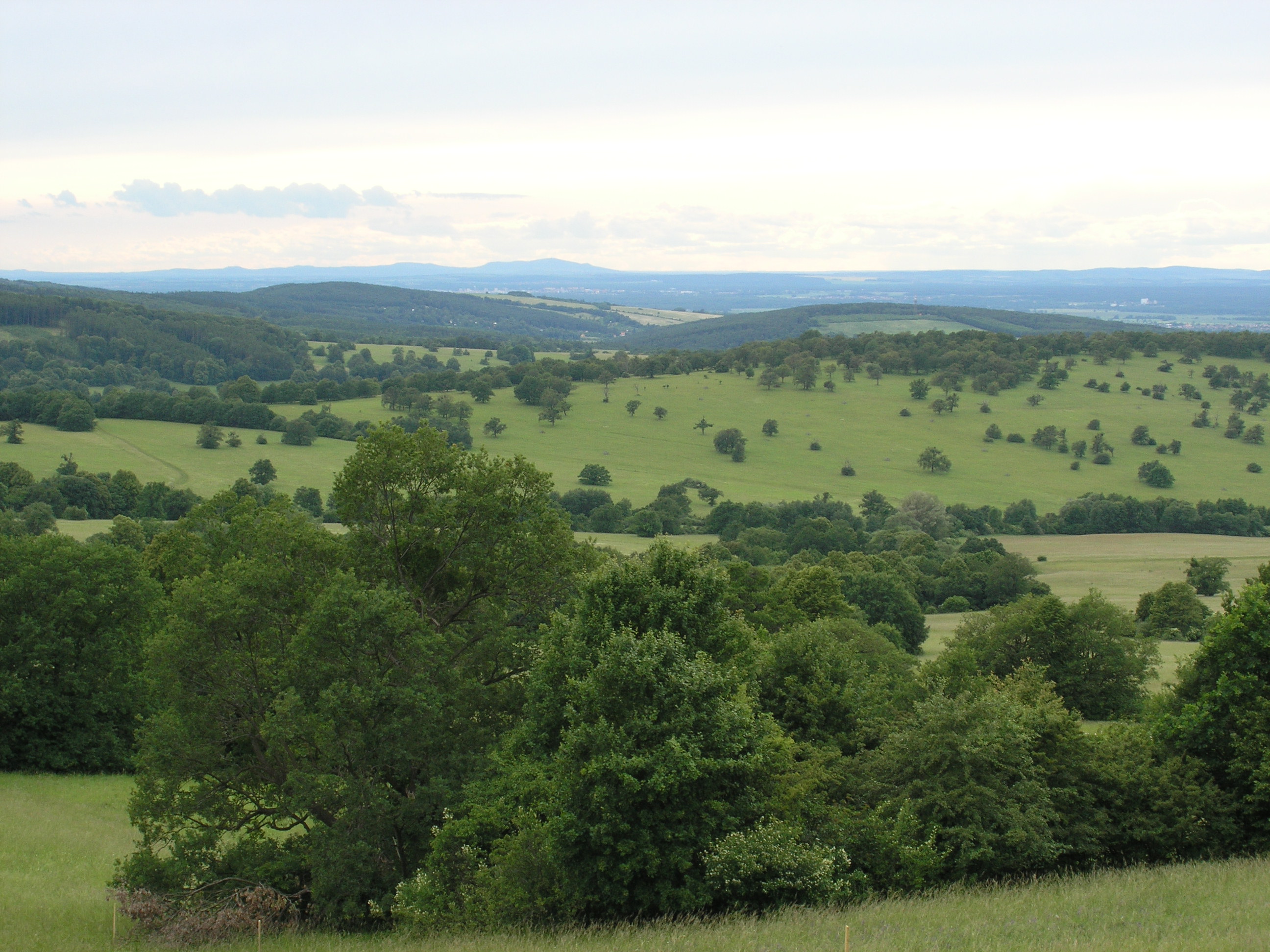
The White Carpathian (Bílé Karpaty) Mts. are important especially for their vast species-rich meadows with many rare and endangered species, often having here very large populations or remarkably isolated occurrences distant from the centres of their natural ranges. Čertoryje Nature Reserve and its buffer zone, which form the majority of the LTER site, is the largest area of this precious habitat in the White Carpathians. Meadows which were not fertilized (or even ploughed up) under socialist agriculture in the second half of the 20th century are the most valuable. These meadows are usually situated on steep slopes which were hardly accessible to the machinery and were thus often totally abandoned and gradually overgrew with expansive grasses and scrub. Their current biological diversity therefore needs resumption of the former extensive management (scrub elimination and subsequent regular mowing without fertilization). These resoration activities started here in the mid 1980s. A fine-scale monitoring of vegetation succession after management restoration at one of these plots is a component of the long-term research here since 1989. The opposite extreme of socialist agricultural management of species-rich meadows was their conversion to arable land. These fields have been gradually re-grassed since 1989. Restoration of the former species-richness is however very slow (or even impossible) and needs special restoration measures. Hence another objective of the local long-term research is the succession on re-grassed arable fields. Spatially detailed observations take place on the eastern slope of the Výzkum hill and are aimed to find out an optimalized economic method of restoring a species-rich meadow (four variants are tested). Except vegetation succession, also the development of several soil fauna coenoses (Testacea, Nematoda, Oribatida, Collembola, Enchytraeidae, Lumbricidae, Oniscidea, Diplopoda, Chilopoda, Opiliones, and Carabidae) has been studied here since 2000. Since 2009, also succession in a broader landscape context is studied, taking into account restored grasslands in a major part of the whole White Carpathian Mountains. More than one tenth of the localities from this landscape study takes place directly in the LTER site, representing about 100 hectares regrassed by a regional species-rich seed mix since 2000 and 30 hectares regrassed by a commercial clover-grass seed mix in the late nineties. The research is focused on both plants (mainly vascular plants, additionally also bryophytes) and animals (Auchenorrhyncha, Heteroptera, Lepidoptera: Hesperioidea, selected phytophagous Coleoptera).
-
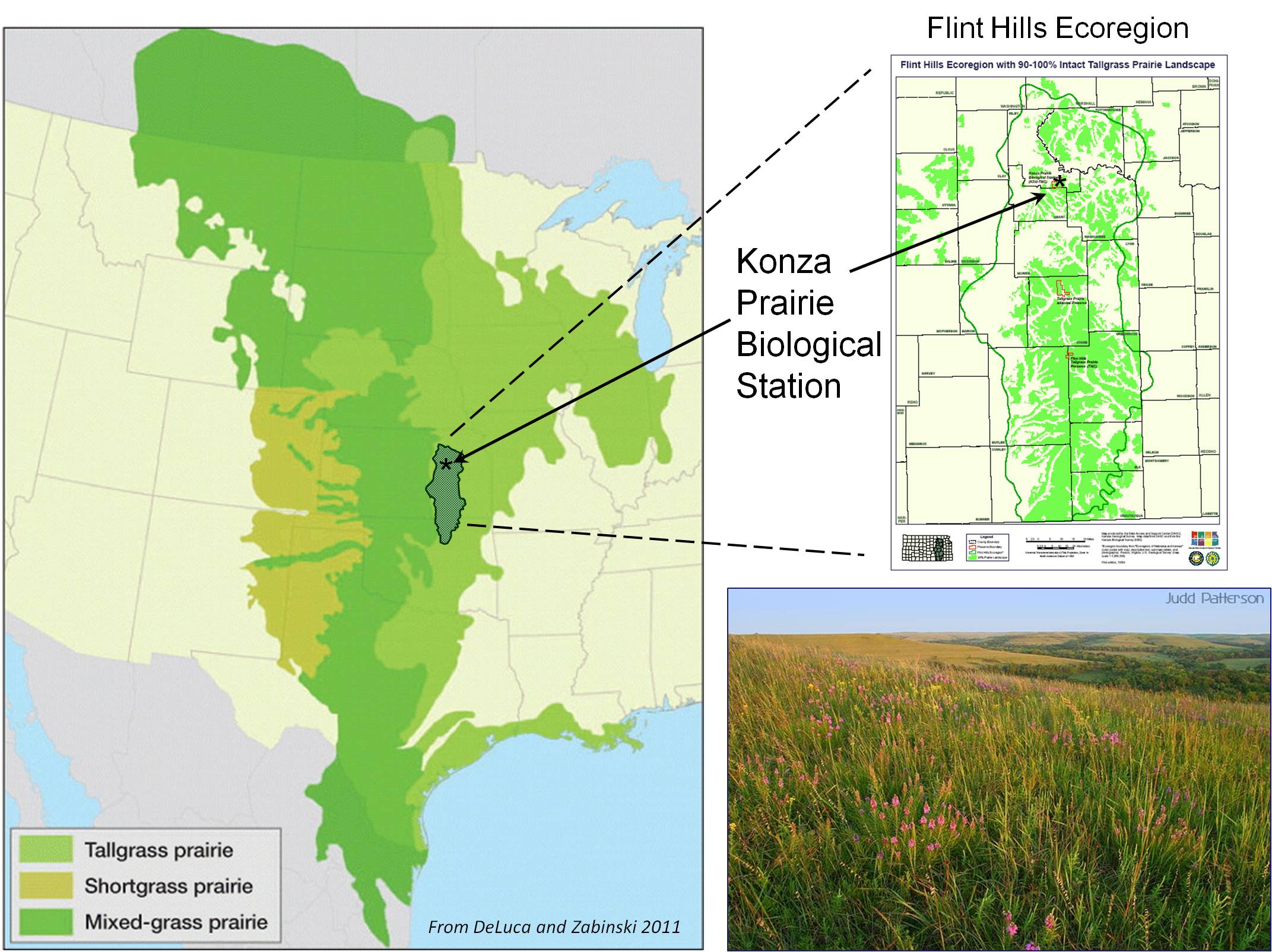
The primary research site for the Konza Prairie LTER program is the Konza Prairie Biological Station (KPBS), a 3,487-ha native tallgrass prairie preserve and research station jointly owned by The Nature Conservancy and Kansas State University. The KPBS is located in the Flint Hills of northeastern Kansas (39°05’ N, 96°35’ W), a grassland region of steep-slopes overlain by shallow limestone soils unsuitable for cultivation. The climate is continental, with mean annual precipitation of 835 mm yr-1, but high variability. KPBS is topographically complex (320 to 444 m asl), and soil type and depth vary with topography. Soils are silty clay loams, formed from thick colluvial and alluvial deposits ≥2 m in lowlands, while hillside and upland soils are shallow. Soils overlay alternating layers of limestone and shale, contributing to complex subsurface hydrology. Vegetation is primarily (>90%) native tallgrass prairie dominated by perennial C4 grasses, but precipitation is sufficient to support woody vegetation, making periodic drought, fire and grazing critical for maintaining grassland. Numerous sub-dominant grasses, forbs and woody species contribute to high floristic diversity (>600 plant species). The entire Kings Creek watershed, a USGS Benchmark Stream, is located on Konza. Hardwood forests occur along major stream courses. Several agricultural fields and restored prairies are located on site. Overall, the site is representative of native tallgrass prairie, with selected areas representing other contemporary land use practices (e.g., agriculture, restored grasslands, cattle and bison grazing).
-
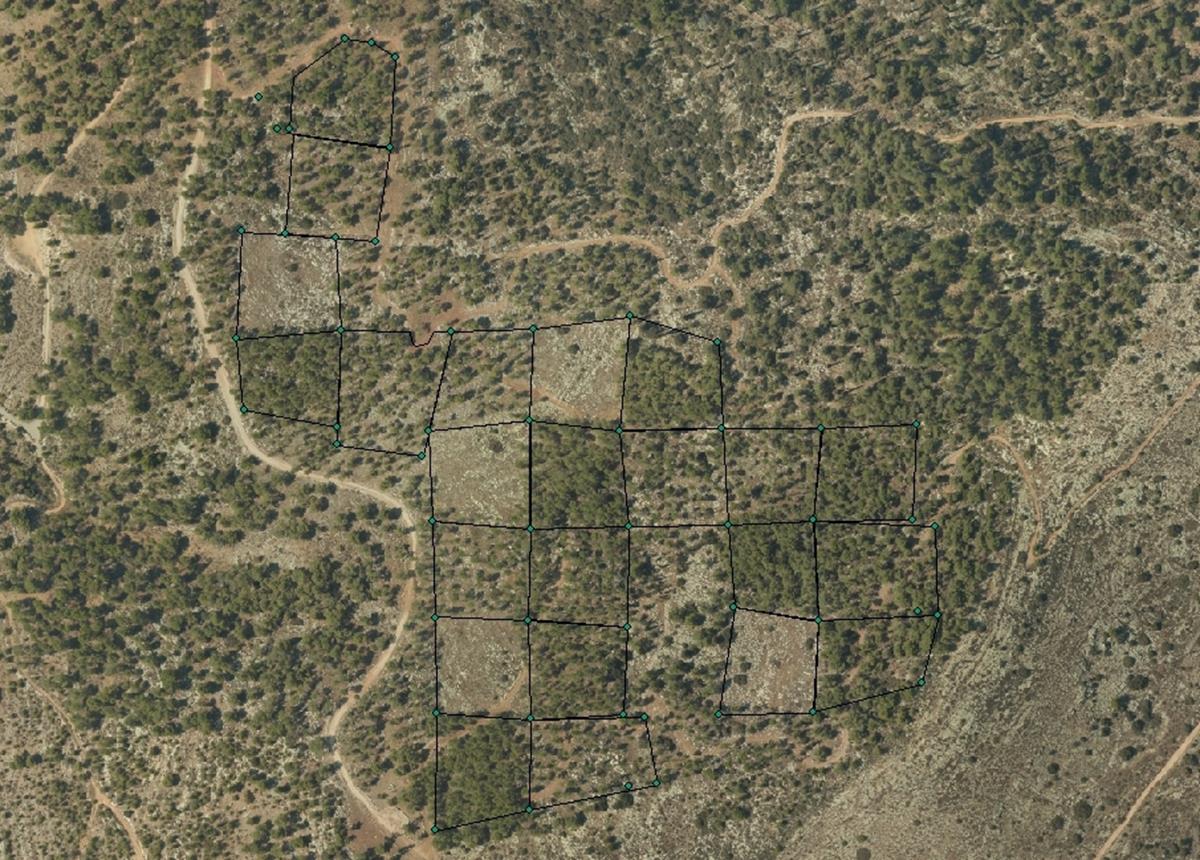
The Kedoshim-forest Long Term Ecological Research (LTER) is an experimental set up established in 2008 in a mature Pinus halepensis forest. This long-term research was designed to address silvicultural issues related to the management of mature, first generation, man-made, pine forest ecosystems in Israel and the design of their next generations as sustainable multiple-use forests. The Kedoshim LTER site is part of the Israeli LTER network - MAARAG. The Kedoshim LTER site provides a comprehensive well designed experimental infrastructure to study long-term effects of silvicultural manipulation (specifically overstory thinning) on vegetation dynamics, forest structure and ecosystem function. Four overstory thinning treatments were applied within 70×70 research plots: 1) clear cut, 2) heavy thinning – 100 tree ha-1 (65% reduction in stem basal area), 3) moderate thinning – 300 tree ha-1 (35% reduction in stem basal area) and, 4) control with no thinning – ca. 500 tree ha-1. Additionally, adjacent non-forested area was assigned as a reference. Climate and microclimate and various aspects of vegetation dynamics, forest function and biodiversity are monitored continuously since the application of thinning treatments.
-
The LTSER Zone Atelier Plaine & Val de Sèvre belongs to LTER-France network and is located in the Poitou-Charentes Region, Western France (46°11’N, 0°28’W, 43m average altitude). The main interests of this zone lie in its large size and the historical data related to monitoring of land use by the CNRS-CEBC over the past 26 years (1994 onwards). The site is bordered by the town of Niort to the north, and Chizé forest massif to the south. Approximately 28,000 inhabitants live in the area, in c. 40 villages. The study area size is 45,000 ha, of calcareous plains which are subjected to a warm-temperate oceanic climate. With a mean annual precipitation of 840 mm and regular summer dryness, mixed oak forests would be the potentially natural vegetation. Rain is scarce in summer. Woodlands are mostly reduced to small and scattered remnant patches (mean patch size = 1.87 ha) and hedgerows are widespread in some areas especially in the cattle breeding sectors. Woods are composed of medium-sized trees, maple, ash, cherry or oak (Acer, Fraxinus, Prunus cerasus or Quercus), with a strong presence of elm (Ulmus). Some of the main human derived landscape features of this area are a suburban zone in the North including many garden areas, a motorway on a North-South axis carrying heavy road traffic, and an electricity substation creating a concentration of high voltage power lines in some areas. The ZAPVS aims to elaborate an alternative agricultural system to the productivist model, for ensuring the sustainable management of natural resources.
-

As the largest contiguous pine forest in Switzerland, the Pfyn forest in Canton Valais (46° 18' N, 7° 36' E, 615 m ASL) offers the best conditions for such measurements. In light of this, a WSL research team installed a long-term experiment of 20 years duration in the Pfyn forest. The average temperature here is 9.2°C, the yearly accumulated precipitation is 657 mm (average 1961-1990). The pines in the middle of the forest are about 100 years old and 10.8 m high. The test area has 876 trees covering 1.2 ha divided into 8 plots of 1'000 m2 each (Image 4). Between the months of April and October four of these plots are irrigated by a sprinkler system providing an additional 700 mm of water, annually. In the other four plots, the trees grow under natural, hence relatively dry conditions.
-
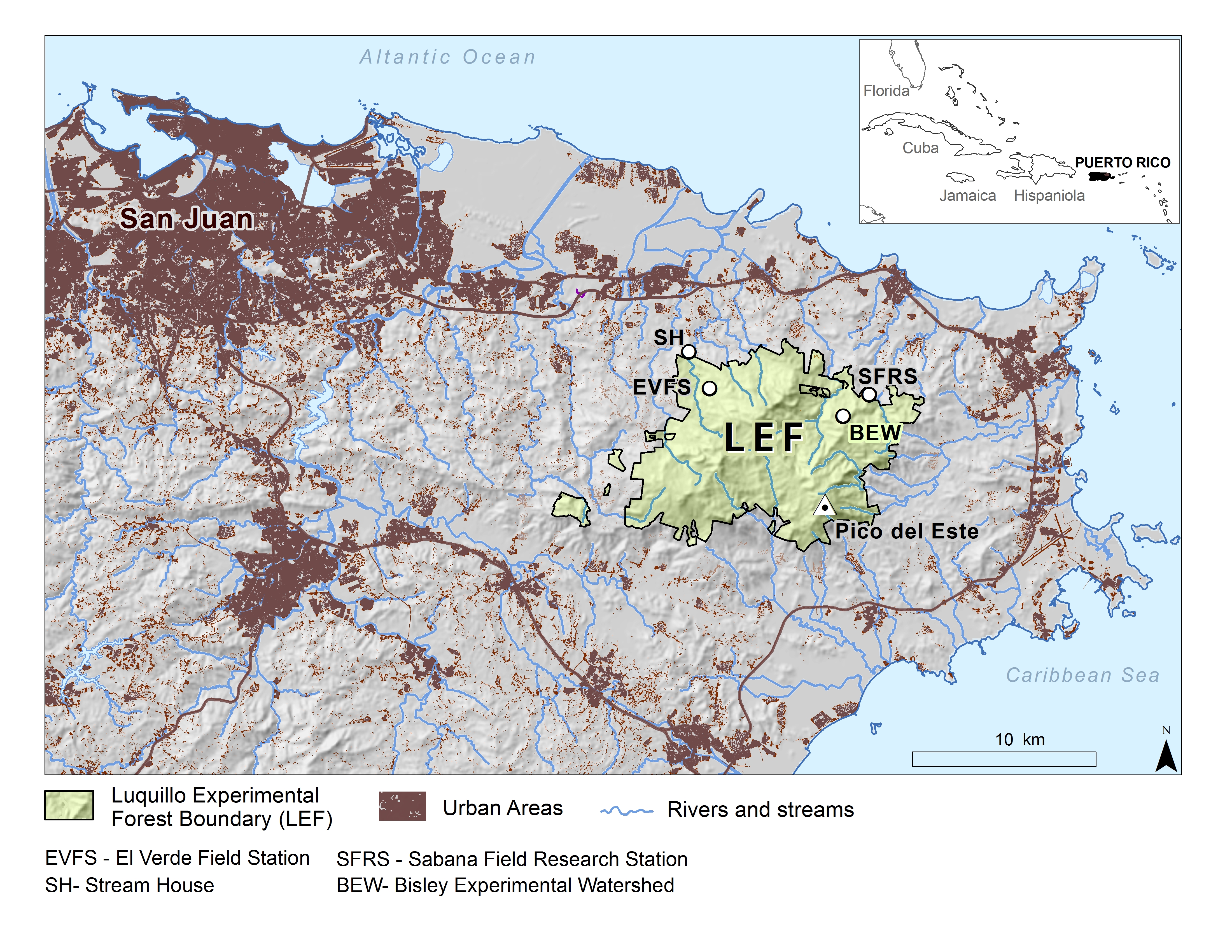
The majority of the Luquillo Long-Term Ecological Research (LUQ) program takes place in the Luquillo Mountains of Puerto Rico. This tropical setting has steep environmental gradients, a varied natural disturbance regime, and a history of human land use. Of the mountain area, 11,330 hectares are included in the Luquillo Experimental Forest (LEF), which is congruent with El Yunque National Forest, part of the U.S. National Forest system. The mountains rise to over 1075 m. Prevailing winds coming off the ocean from the east drop rain as they rise over the mountains; thus rainfall increases with elevation, ranging from about 3530 mm/year at low elevations to 4850 mm/year higher up. February through April are the drier months, but monthly rainfall is variable. Mean monthly temperatures at lowest elevations range from about 23.5ºC in January to 27ºC in September, and at the highest elevations from 17ºC to 20ºC (Climate and Hydrology). The geology of the Luquillo Mountains is mainly described as igneous rock formed in the Cretaceous, with some intrusive materials from the Tertiary. Soils are deep, weathered, and moderately rich in nutrients. Little humus accumulates, due to rapid decomposition, except in local areas at upper elevations, where decomposition seems to be inhibited by waterlogging. There are four main life zones, delineated on the basis of temperature and precipitation (Holdridge System), in the Luquillo Mountains: subtropical wet and subtropical rain forests are found at low and mid elevations, lower montane rain and lower montane wet forests at high elevations. There is also an area of subtropical moist forest at low elevations on the southwest slope. Natural disturbances in the Luquillo Mountains include hurricanes, landslides, treefalls, droughts, and floods. Human disturbances, mainly in the past, include road construction, charcoal production, clearing for pasture and crops, creation of coffee plantations, and logging. The forests are classified into four types: "tabonuco forest", "palo colorado forest", "palm forest", and "elfin woodland forest". Ascending the Luquillo Mountains through these forest types, shows a distinctive forest dynamic with the average tree height and diameter, number of tree species, and basal area (cross sectional area of tree stems) tend to decrease, while stem density increases. Epiphytes become more common with elevation. The animal community in the Luquillo Mountains exhibits several distinctive characteristics that affect the structure of its food web. The characteristics are a product of tropical location, disturbance regime, and spatial and temporal constraints related to island size, distance and history of isolation from continents. The only native mammal in the area are bats, all other mammals (cats, rats, and mongooses) are introduced. Birds include several species endemic to Puerto Rico, such as the Puerto Rican Tody, an understory insectivore, and the Puerto Rican Parrot, an endangered species. Streams in the Luquillo Mountains have steep channels with many boulders and series of pools and riffles. The dynamics of stream ecosystems are strongly influence by physical factors, such as the rapid change in elevation from headwaters to coastal plains, the intensity and frequency of rainfall events, and the high temporal variability of stream discharge.
-
Fagus sylvatica forest on limestone plateau
-

The ZA PYGAR covers the whole Garonne river basin up to the upper part of the Gironde estuary (La Reole station). Within this territory, research is structured around 4 main sites: the Pyrénées mountains, covering the upstream part of the Garonne river basin (PYRénées site), the farmland of the foothills of the Pyrénées (Vallées et Coteaux de Gascogne site), the Garonne river (Axe Fluvial Garonne site) and the basin of two tributaries of the Garonne river in the Massif Central moutains (Aveyron-Viaur site).
-
Sugadaira Montane Research Center, established in 1934, is located on the mountain region of 1,300 m alt. in Nagano Prefecture, central Honshu-Island, Japan. In the extensive campus of the Center (35 ha), a sere of vegetation succession is well preserved, and seral stages of the secondary succession for the last one hundred years are sequentially and chronologically arranged: a Miscanthus grass field (A) - young pine forest (about 45 year-old) (B) - mature pine forest (about 60 year-old) (C) - older deciduous broad-leaved forest (about 100 year-old) (D).
-

Monitoring stations in Aukštaitija NP started functioning in 1993. Aukstaitija station (LT01) was founded in strict reserve zone of Aukstaitija national park in Ažvinčių old forest, Versminis river closed basin. The area of the basin is 101.5 ha. The lowest place is at 159.5 m, the highest - 188.6 m above sea level. Geographical co-ordinates of the basin are: longitude - 26*03*20* - 26*04*50*, latitude - 55*26*00* - 55*26*53*. The climate is characterised as average cold with high humidity and abundant precipitation. The average air temperature is 5.8 C, average precipitation - 682 mm. Length of vegetation period - 189 days. Side glavioacvalic accumulation forms with sand, gravel and stones are typical for river basin and in the western part of the basin, with the decrease of surface altitude transfers into fliuvioglacial terrace delta plain with fine sand, and at the source- into marsh accumulation forms with organic sediments. At the eastern side of the basin, which has higher altitudes, the typical for this basin glavioacvalic accumulation forms transfer into gravel sand. Carbonates start foaming at 45 cm depth (Gulbinas et al., 1996). The saturation of the river water with the oxygen is very weak. The average yearly oxygen concentration equals to 2.9 mg/l (minimal allowable concentration – 6 mg/l). The pH value of the water fluctuates from 7.10-7.75 mg/l, which indicates the alkalisation of the water. Concentration of hydro-carbonate ions varies in the intervals of 148-224 mg/l. Concentrations of sulphates and chlorides are very small. Calcium and magnesium ions are dominating in the media of cations. Concentration of natrium ions is insignificant – 2 mg/l 9DLK=120 mg/l), concentration of kalium ions reaches only tenths of mg/l (DLK=50 mg/l). According to the size of mineralisation the river water could be described as having average mineralisation levels. Concentrations of nitrogen materials (ammonium nitrogen, nitrates) are small, compared to maximum allowable concentrations (DLK) set for surface waters. Concentrations of phosphates are small. Silicium concentrations fluctuate from 2 mg/l to 9 mg/l (Čeponienė, 1997). Main ecosystems Coniferous multi-layered forest stands are prevailing in the basin, which are mainly pine trees with a mixture of spruce. Those stands usually have a second and third tree layer with abundant under layer vegetation. Spruce stands are also of complicated structure. The second and third spruce layer with abundant under layer vegetation are common. Remarkable amounts of territory are occupied by mixed conifer-deciduous or mixed conifer forests. Pure birch stands in more wet habitats in the vicinity of Versminis river source can also be found. According to the forest stand age they are old pure overmature or with accompanying forest stands of several age classes. It is mainly multi-aged and multi-layered over mature pine and spruce stands. In addition The study was based on monitoring data on crown defoliation of more than 3000 Scots pine (Pinus sylvestris L.) trees from 20 permanent observation stands (POS) annually obtained between 1994 and 2009 in Aukstaitija national park (ANP), located in the eastern part of Lithuania (Fig. 1). Over 16yr period mean values of crown defoliation of every sample pine stand were computed annually. Therefore the total number of treatments made N=320. These stands were classified according to stand maturity: 4 sapling stands (45 to 50 years – Table 1, section “Stand maturity”, group 1), 5 middle aged stands (61 – 80 years – group 2), 4 premature stands (81-100 years – group 3), 3 mature stands (101-120 years – group 4) and 4 over mature stands (> 121 years – group 5). Main characteristics of the considered stands are compiled in table 1. All stands represent the prevailing in Lithuania Pinetum vaccinio-myrtilosum forest type.