
elevated temperature
Type of resources
Available actions
Topics
Keywords
Contact for the resource
Provided by
Years
Formats
Representation types
-
The meteorological sensors are located on the roof of the main building of the Biological Station (N 47,7691; E 16,7662; Position (elevation): 122 msl) in the close vicinity of Lake Neusiedl. The parameters that are on-line recoded every 15 minutes are as follows: Air humidity (%RH), Global radiation (W/m²), Air temperature (°C), Wind speed ([Average] (km/h), Wind direction (°), Rain yearly (mm), Precipitation (mm); time resolution: 15 minutes. There are also two traditional weather stations at the station and on the jetty, which are maintained by the Hydrolographic Service Burgenland and enable parameters such as temperature, humidity, precipitation and water level to be recorded. In addition to the Adcon weather station on the roof of the station, there are currently 3 other stations in operation in Seewinkel. These positions are: • Unterer Stinkersee (N 47,8018; E 16,7842) • Neudegg (N 47,7029; E 16,8098) • Östliche Fuchslochlacke (N 47,7907; E 16,8624)
-
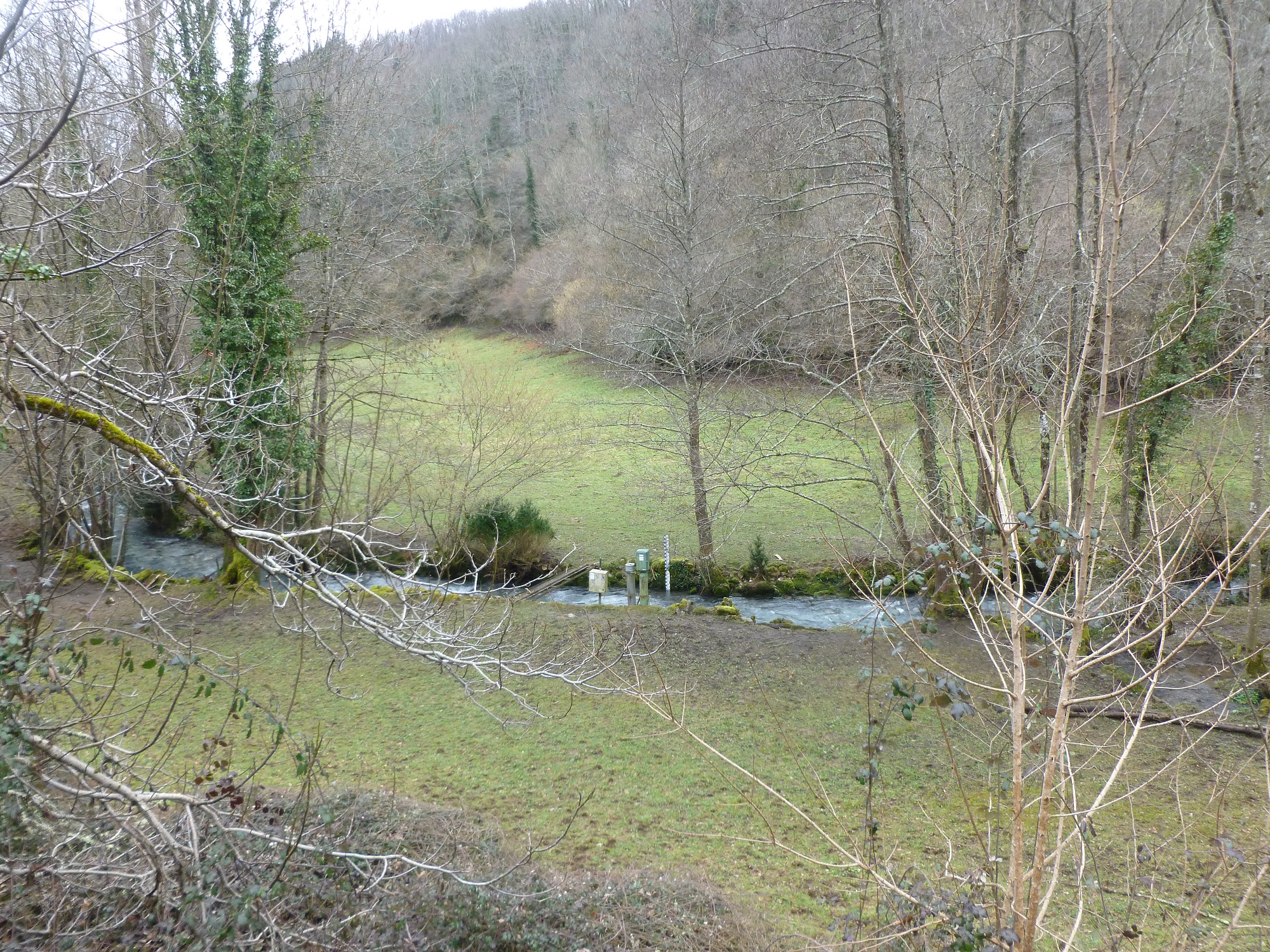
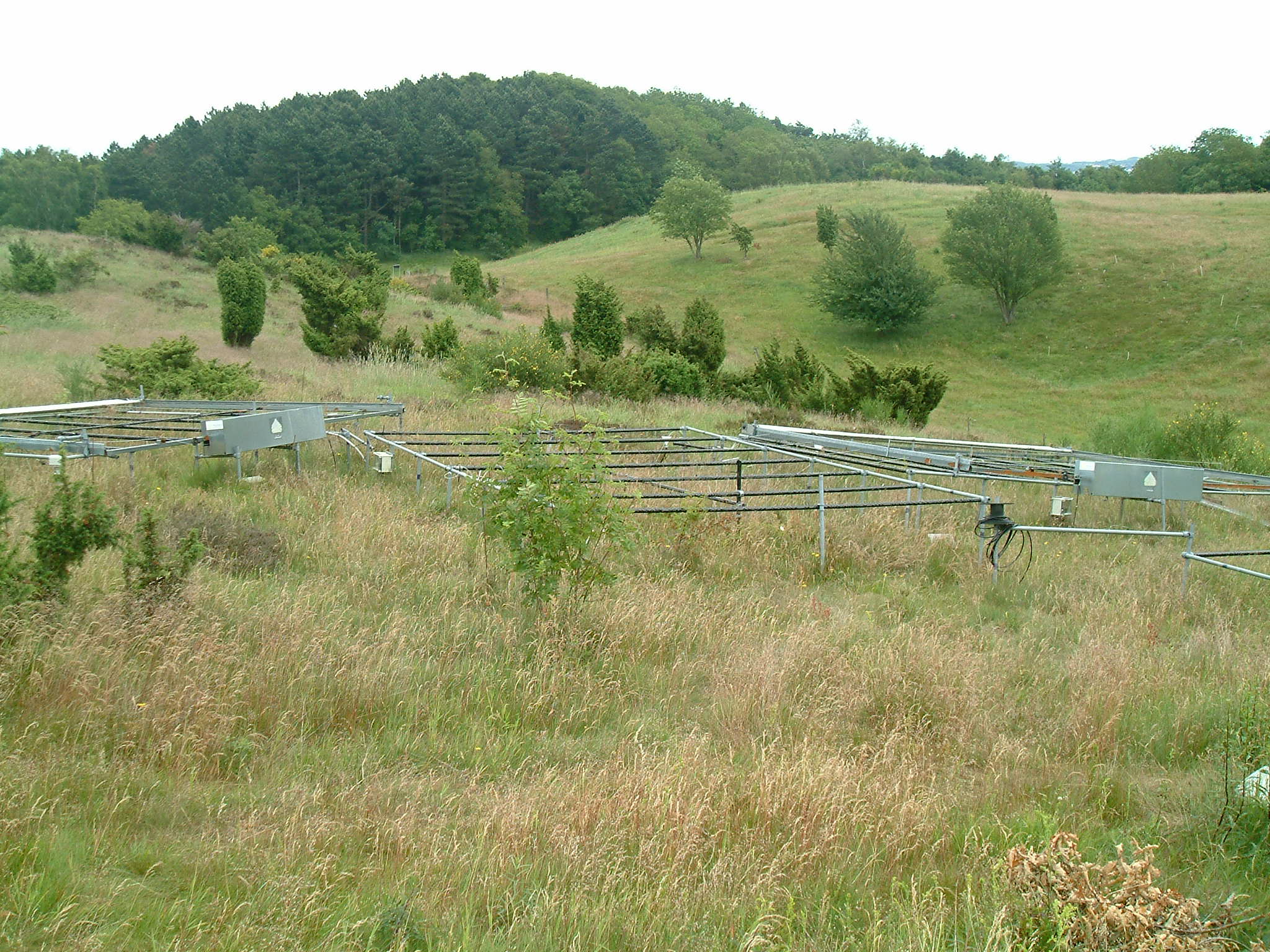
The Baget catchment is managed by the Laboratory of Functional Ecology and Environment (EcoLab), a joint Research Unit between the Institute of Ecology and Environment (INEE) of CNRS, the National Polytechnic Institute of Toulouse and the University Toulouse III-Paul Sabatier, in collaboration with BRGM (Occitania regional agency), the laboratory Geosciences and Environment Toulouse (GET) and the Station of Theoretical and Experimental Ecology (SETE) in Moulis (Ariège, France). The Baget catchment (Pyrénées, Ariège, France) is a mountain ecosystem of middle altitude (Alt.= 1000 m) receiving around 1000mm of precipitation per year. Located close to Balagué village at 10 km West from Saint-Girons, the Baget catchment (13.25 km2) is drained by a karstic network which supplied the surface runoff of Lachein stream (specific discharge: 36 l.s-1.km-2). It is a tributary of the Lez which joins the Salat River, right tributary of the Garonne River. From 1968, this experimental site was intensively equipped by the CNRS underground Laboratory of Moulis (today SETE). The device is composed of one main weir at the outlet, 3 full excess controls, 3 piezometers of which one inside the abyss, and one subterranean loss. This karstic watershed has been surveyed since 1968 for some hydro-climatic parameters, particularly air temperature, precipitations and stream discharge at the outlet. Some geochemical parameters (pCO2, chemical and isotopic compositions of waters) and some hydro-biological and ecological data (invertebrates, particularly Crustacea) have been surveyed for periods during the last 40 years by the CNRS underground Laboratory of Moulis. Since 2011, Baget catchment belongs to the French Network of Catchments (RBV) and it is included in the certified National Observatory Service SNO Karst. Then, new parameters are measured twice a month or with higher frequencies during some flood events (major cations and anions, alkalinity, pH, conductivity, dissolved organic carbon, total suspended matter, H, O, C isotopes…). Since 2014, a multi-parameter probe has been installed with different sensors to measure continuously water level, pH, conductivity, turbidity, dissolved oxygen, nitrate and chloride. These continuous measurements are calibrated twice a month with laboratory analyses. The water discharge is measured by BRGM-Occitania because the Baget karst is part of the French patrimonial network of ground-waters and it belongs to the piezometric network managed by BRGM. The Baget catchment is very sensitive to limit conditions of surface drainage and to land covers. It offers the possibility to develop an eco-systemic survey, which integrates the hydrology, the geochemistry and the ecology of a mountain ecosystem in the SW of France. In this region, climate and land use changes will have significant impacts on biodiversity, ecosystem functioning and biogeochemical cycles for the next decades The Baget catchment is an international field site of the Critical Zone Exploration Network CZEN (http://www.czen.org/content/aurade-experimental-catchment) and it is one of the sites of the French SNO-KARST (Service National d'Observation) labellised by INSU-CNRS. It belongs to the French Research Infrastructure OZCAR and it is also a site of the French LTSER ZA PYGAR "Zone Atelier Pyrénées-Garonne".
-
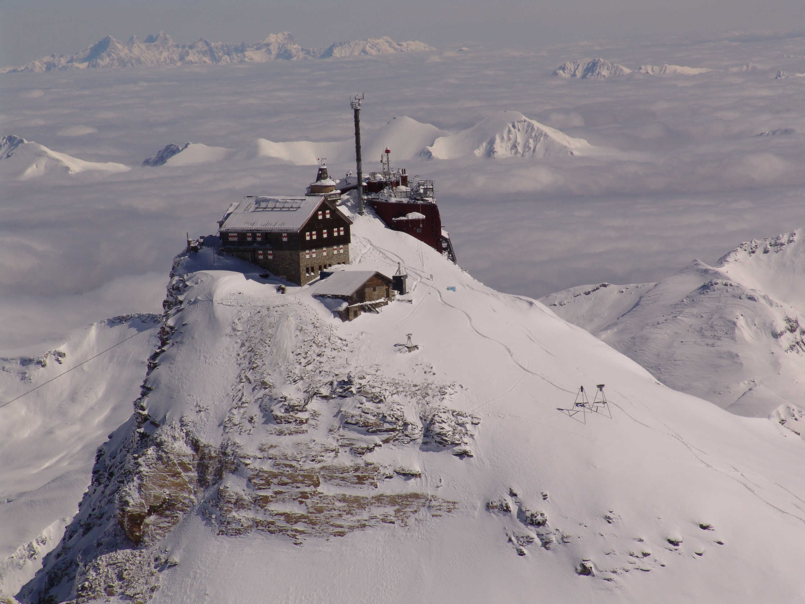
The Sonnblick Observatory is located in the Austrian Central Alps at an elevation of 3100 m a.s.l. It is situated at the alpine main divide, which is a clear climatological border. It also lies in the “Nationalpark Hohe Tauern” which covers 1856 km2 of the Austrian Alps. Research of the Sonnblick Observatory is currently formulated in the research programme ENVISON. It covers three main topics (the atmosphere, the cryosphere, and the biosphere) in an extensive monitoring programme and with many research projects.The Sonnblick Observatory is outstanding with respect to its long-term climate observations and studies on glacier changes. Thus, the impact of Climate Change on the cryosphere is a major research topic at the Sonnblick Observatory. Since 1886, the observatory is also involved in many international projects on atmospheric chemistry and atmospheric physics. The research is described on www.sonnblick.net. The Sonnblick Observatory cooperates with several Austrian and international universities/research institutions. Within the frame of the GAW-DACH cooperation, Sonnblick has a special partnership with the observatories Jungfraujoch (in Switzerland), Zugspitze and Hohenpeissenberg (both Germany) for common research on atmospheric processes and Climate Change. The Sonnblick observatory ist part of the BSRN-Network, LTER Austria, ACTRIS, etc. Data are available via the SBO Data Portal. In the frame of eLTER the SBO will be part of the eLTSER Cluster NPHT.
-
Lake Beyşehir, the largest freshwater lake in Turkey as well as in the Mediterranean basin, has a surface area of approximately 650 km2 and mean and max depth of 5–6 and 8–9 m, respectively. The catchment is situated in a semidry Mediterranean climate having an average temperature of 11 °C and an annual total precipitation of 490 mm during 1960–2012. In this period, precipitation values fluctuated between 317 and 716 mm (Beyşehir meteorology station, www.mgm.gov.tr), and the lowest annual average temperature was recorded in 1992 (8.5 °C) the highest in 2010 (13.1 °C). The catchment area of the lake is 4704 km2. The northern and eastern parts of the catchment are flat and intensively used for crop farming, while the western part of the catchment is dominated by mountains covered with forests and small areas of low-intensity agriculture. Nearly half of the catchment (42.7%) is covered by range-brush, 25.5% by agricultural land, and 13.5% by water (including Lake Beyşehir, the inflows, and wetlands), while forested areas (evergreen and deciduous forests) constitute 11.2%. The elevation ranges between 1027 and 2958 m.a.s.l., with an average elevation of 1370 m.
-
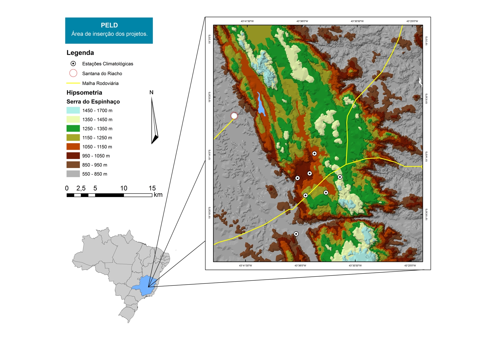
For over 20 years as a team of Long Term Sites in Serra do Cipó PELD-CRSC has been working to answer crucial questions of evolutionary ecology and provide a basis for understanding the spatio-temporal ecosystem functioning and it is future challenges with changes in climate and land use.
-
The Ploemeur-Guidel observatory (Britanny, France) is focusing on surface-depth relationships in a fractured crystalline geological context and oceanic climate. It is built on 2 sub-sites, one highly anthropized, the other in natural state. In Ploemeur, groundwater has been pumped since 1991, supplying more than 1 million m3 of clean drinking water annual at a sustainable rate. Such high productivity is explained the specific fractured network in granite and micaschists, draining deep geological layers (~400 m). Extracted water quality is very good, with limited nitrate concentration, in a region that has been strongly affected by widespread pollution. Guidel site is in a similar, but natural context. Deep iron-rich groundwater is upflowing, creating surface and deep groundwater-dependent ecosystems, and feeding a classified coastal wetland. Both sites have a very dense equipment to study rapid to long-term surface-depth exchanges: a flux tower, unsaturated zone monitoring, a network of ~50 shallow (<10m) and deep boreholes (>80m), hydrochemical, temperature and deformation. An well-characterized fractured experimental site offers the possibility to conduct experiments to test innovative instruments and develop new methodologies
-

Historically, the role of the Galapagos Islands has been considered critical due to the evolutionary diversification induced by natural and historical isolation. The Galapagos National Park was established in 1959, based on its historical importance associated with Charles Darwin's voyage and its rare and endemic biodiversity, composed of unique vertebrate and plant communities (Rozzi et al. 2010). In 1978, the Galapagos Islands were declared a UNESCO World Heritage Site, a critical factor associated with this national park (Rozzi et al. 2010). The Galapagos Islands are a pristine area with local and regional climates influenced by the interaction of ocean currents and winds driven by the Inter-Tropical Convergence Zone; ITCZ (Conroy et al. 2008, Trueman and d'Ozouville 2010). The long-term programme includes forty natural aquatic ecosystems (lakes, ponds, lagoons and swamps) that will be sampled on the islands of San Cristobal, Santa Cruz, Isabela and Floreana, where possible along a lowland-highland gradient. The number of sampling points will vary according to environmental heterogeneity and the presence of a littoral region, among other factors.
-

Monitoring stations in Aukštaitija NP started functioning in 1993. Aukstaitija station (LT01) was founded in strict reserve zone of Aukstaitija national park in Ažvinčių old forest, Versminis river closed basin. The area of the basin is 101.5 ha. The lowest place is at 159.5 m, the highest - 188.6 m above sea level. Geographical co-ordinates of the basin are: longitude - 26*03*20* - 26*04*50*, latitude - 55*26*00* - 55*26*53*. The climate is characterised as average cold with high humidity and abundant precipitation. The average air temperature is 5.8 C, average precipitation - 682 mm. Length of vegetation period - 189 days. Side glavioacvalic accumulation forms with sand, gravel and stones are typical for river basin and in the western part of the basin, with the decrease of surface altitude transfers into fliuvioglacial terrace delta plain with fine sand, and at the source- into marsh accumulation forms with organic sediments. At the eastern side of the basin, which has higher altitudes, the typical for this basin glavioacvalic accumulation forms transfer into gravel sand. Carbonates start foaming at 45 cm depth (Gulbinas et al., 1996). The saturation of the river water with the oxygen is very weak. The average yearly oxygen concentration equals to 2.9 mg/l (minimal allowable concentration – 6 mg/l). The pH value of the water fluctuates from 7.10-7.75 mg/l, which indicates the alkalisation of the water. Concentration of hydro-carbonate ions varies in the intervals of 148-224 mg/l. Concentrations of sulphates and chlorides are very small. Calcium and magnesium ions are dominating in the media of cations. Concentration of natrium ions is insignificant – 2 mg/l 9DLK=120 mg/l), concentration of kalium ions reaches only tenths of mg/l (DLK=50 mg/l). According to the size of mineralisation the river water could be described as having average mineralisation levels. Concentrations of nitrogen materials (ammonium nitrogen, nitrates) are small, compared to maximum allowable concentrations (DLK) set for surface waters. Concentrations of phosphates are small. Silicium concentrations fluctuate from 2 mg/l to 9 mg/l (Čeponienė, 1997). Main ecosystems Coniferous multi-layered forest stands are prevailing in the basin, which are mainly pine trees with a mixture of spruce. Those stands usually have a second and third tree layer with abundant under layer vegetation. Spruce stands are also of complicated structure. The second and third spruce layer with abundant under layer vegetation are common. Remarkable amounts of territory are occupied by mixed conifer-deciduous or mixed conifer forests. Pure birch stands in more wet habitats in the vicinity of Versminis river source can also be found. According to the forest stand age they are old pure overmature or with accompanying forest stands of several age classes. It is mainly multi-aged and multi-layered over mature pine and spruce stands. In addition The study was based on monitoring data on crown defoliation of more than 3000 Scots pine (Pinus sylvestris L.) trees from 20 permanent observation stands (POS) annually obtained between 1994 and 2009 in Aukstaitija national park (ANP), located in the eastern part of Lithuania (Fig. 1). Over 16yr period mean values of crown defoliation of every sample pine stand were computed annually. Therefore the total number of treatments made N=320. These stands were classified according to stand maturity: 4 sapling stands (45 to 50 years – Table 1, section “Stand maturity”, group 1), 5 middle aged stands (61 – 80 years – group 2), 4 premature stands (81-100 years – group 3), 3 mature stands (101-120 years – group 4) and 4 over mature stands (> 121 years – group 5). Main characteristics of the considered stands are compiled in table 1. All stands represent the prevailing in Lithuania Pinetum vaccinio-myrtilosum forest type.
-
Mols Bjerge National Park or Nationalpark Mols Bjerge is a Danish national park in the area known as Mols Bjerge (lit.: Mols Hills) in Syddjurs Municipality, Central Jutland, inaugurated on the 29th of August 2009. The protected area, measures 180 square kilometres (69 sq mi) in size. The Mols Hills, reaching a height of 137 metres (449 ft), are centrally located in the park, and take up 2,500 ha. "More than half of all wild Danish plant species" can be found at Mols Bjerge. The park comprise most of the southern parts of the headland of Djursland. It is bounded on the east by the sea of Kattegat, the forests of Kaløskovene in the west and to the south by multiple inlets, coves and plains of glacially generated moraine. The town of Ebeltoft, along with villages and summer house residence areas, are considered part of the park. Land in the national park is held under both private and state ownership. Nearly 33% of the park is cultivated and 80% of the hill area is under private ownership. Mols Bjerge National Park has a rolling and widely varying topography of woodlands and open countryside, created with the end of the last ice age. Elevation in the park area varies in height rising to a maximum of 137 metres (449 ft) in Mols Hills, with many types of habitats such as heath, forests, pastures, bogs, meadows, a variety of coastal habitats and sea
-
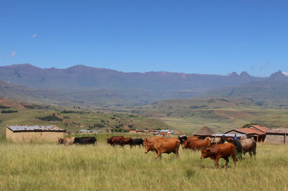
The Cathedral Peak research catchments in the northern uKhahlamba Drakensberg mountains, KwaZulu-Natal, South Africa have been a focus of observation research since the 1940’s. The Drakensberg mountains which fall in the grasslands biome, are a crucial water source area for South Africa, owing to the relatively high rainfall and ratio of rainfall to runoff conversion in this region. This portion of southern Africa's grassland biome also supports phenomenal levels of biodiversity. The research catchments themselves are primary, headwater catchments that fall within a protected area. The catchments were initially established to investigate the influence of various land management treatments on water but over time the research has broadened to a more interdisciplinary focus incorporating carbon–water–energy–biodiversity and the dynamics between these. Although the core of the observation and monitoring is sited in the catchments, the research extends beyond the protected area into communal, state, and privately owned lands. The land beyond the protected area is valued for agriculture, ranging from subsistence agriculture in impoverished villages to large-scale commercial agriculture. Scientific work in the landscape continues to grow and expand.