
environmental parameter
Type of resources
Available actions
Topics
Keywords
Contact for the resource
Provided by
Years
Formats
Representation types
-
The Caribou-Poker Creeks Research Watershed (CPCRW) is a relatively pristine, 104 km2, basin reserved for meteorologic, hydrologic, and ecologic research, with no current human influence (other than scientific research). The CPCRW is the only research watershed in the United States located in the region of discontinuous permafrost, which comprises a large portion of Alaska and most of interior Alaska.
-
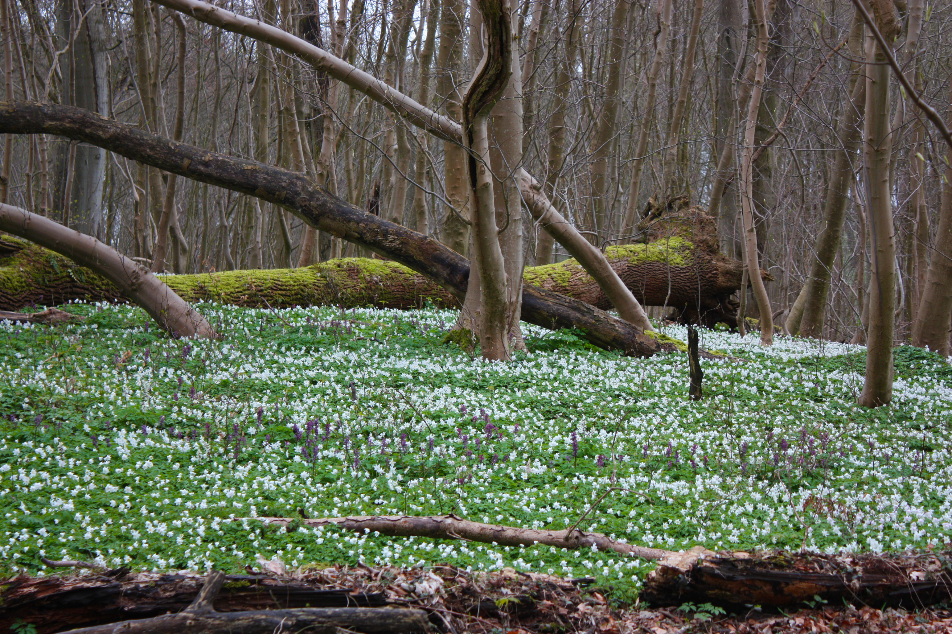
The main focus of the monitoring is the university's own forest nature reserve Eldena. In the immediate vicinity of Greifswald, the approximately 400 ha large protected area comprises near-natural, deciduous beech-ash mixed forests on ground moraine sites. Due to the hydromorphic soils, which made agricultural use difficult, a very long forest continuity can be assumed. This can be seen, among other things, in a very extensive early geophyte carpet of anemones, larkspur, bogweed and other species of impressive beauty. Originally owned by the Cistercian monastery of Eldena and the Pomeranian dukes, the area passed to the University of Greifswald in the 17th century. Intensive drainage works and the introduction of modern forestry in the 19th century changed the forest picture from wet, intensively used coppice and Hude forest with typical species such as hornbeam, oak or hazel, to beech dominated high forest. Remains of this former use have been preserved to this day in old, large-crowned oak trees, especially in the natural forest plots, which together cover about 30 hectares and are not used for forestry. The use of the forest during the war and reparation cuts after 1945 led to strong clearings, which are reflected in today’s age structure of the forest area. The forest has been a nature reserve since 1969. Detailed pollen, vegetation and soil studies are available for the area. Investigations of charcoal piles and old cartographic works shed light on the historical tree species inventory and use. The monitoring is supplemented by satellite sites in alder forests. Here, specific questions, for example on the influence of rewetting and drainage on biomass and peat formation, are investigated.
-
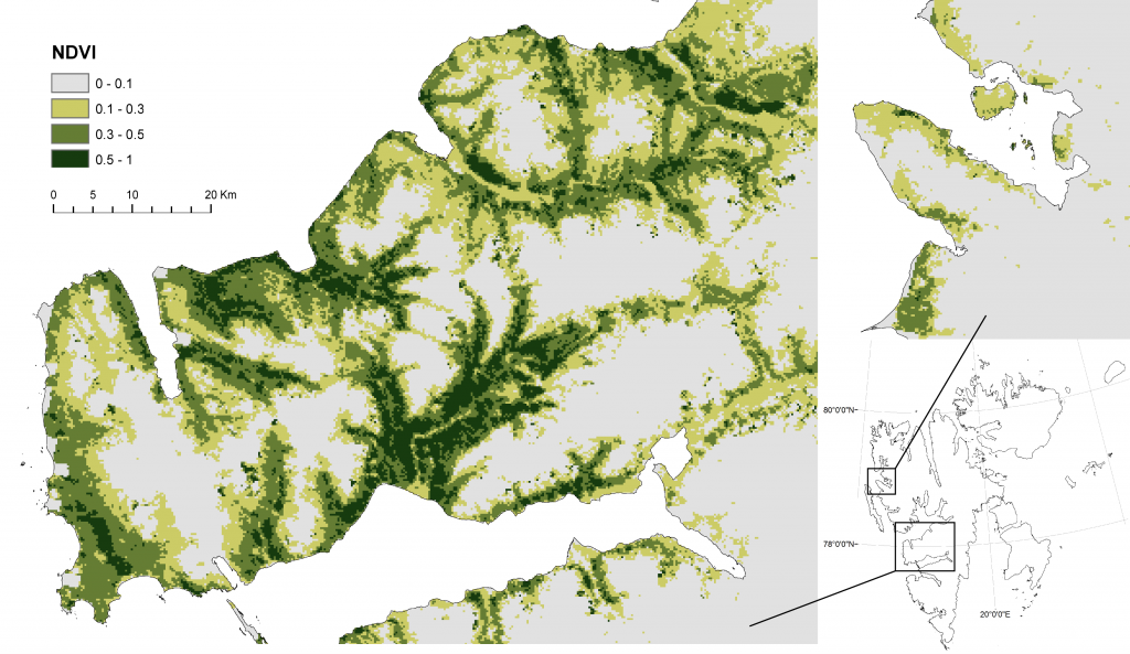
COAT Svalbard is a subsite under the COAT platform located on the Svalbard Archipelago in the high Arctic. Long-term monitoring and research on tundra ecosystems are conducted on this site.
-
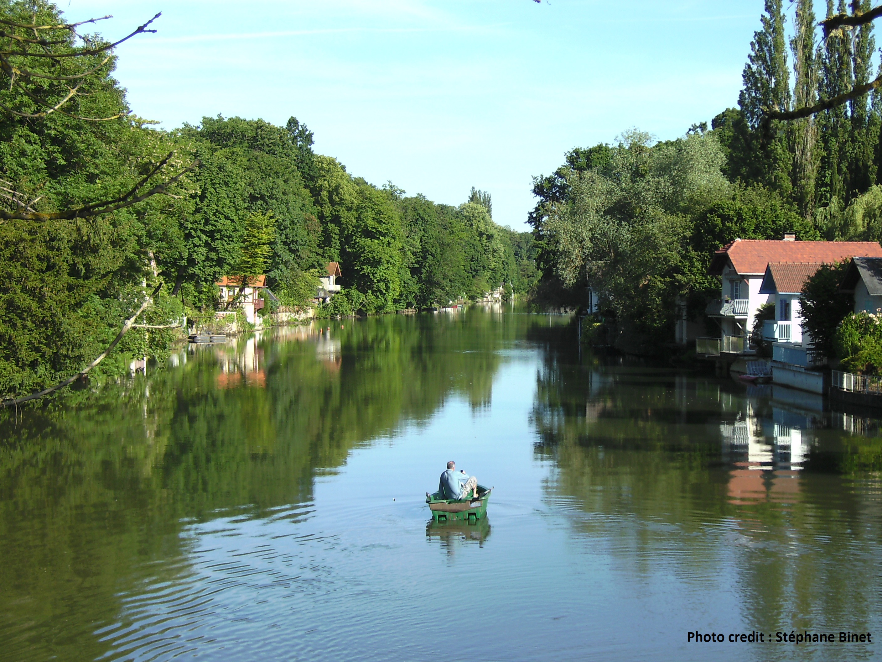
The Val d’Orléans is a vast depression in the Loire River main flow, 37 km long and from 4 to 7 km wide. This is a saturated karst aquifer, hosted within a carbonate lacustrine deposit called the Beauce limestone with a high porosity overlain by the Quaternary alluvia of the Loire River. The Loire River feeds more than 80% of the water hosted in the carbonate karst aquifer (11.5 m3/s during low water periods). Water outflows toward several resurgences of the Loiret River through a saturated karst networks.
-
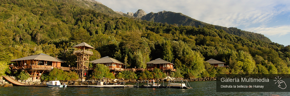
Patagonian Forest (old-growth and second growth), with final intervention of 50 years.
-
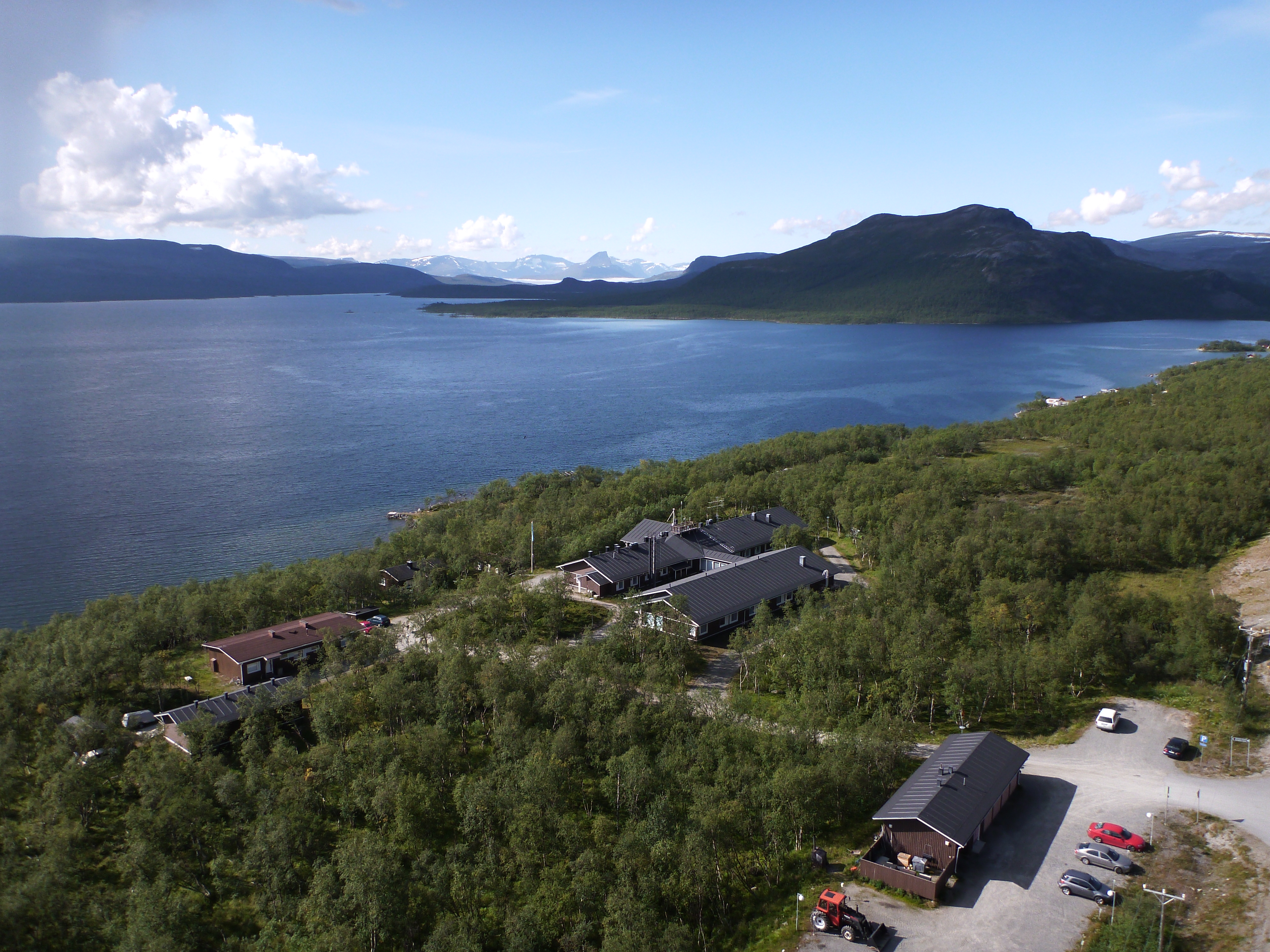
A steep and deep (500 m) fjord with temperate rain forest and glaciers on top of the mountains, many small and one large river entering the fjord (without glacial sediment), few inhabitants, no road access.
-
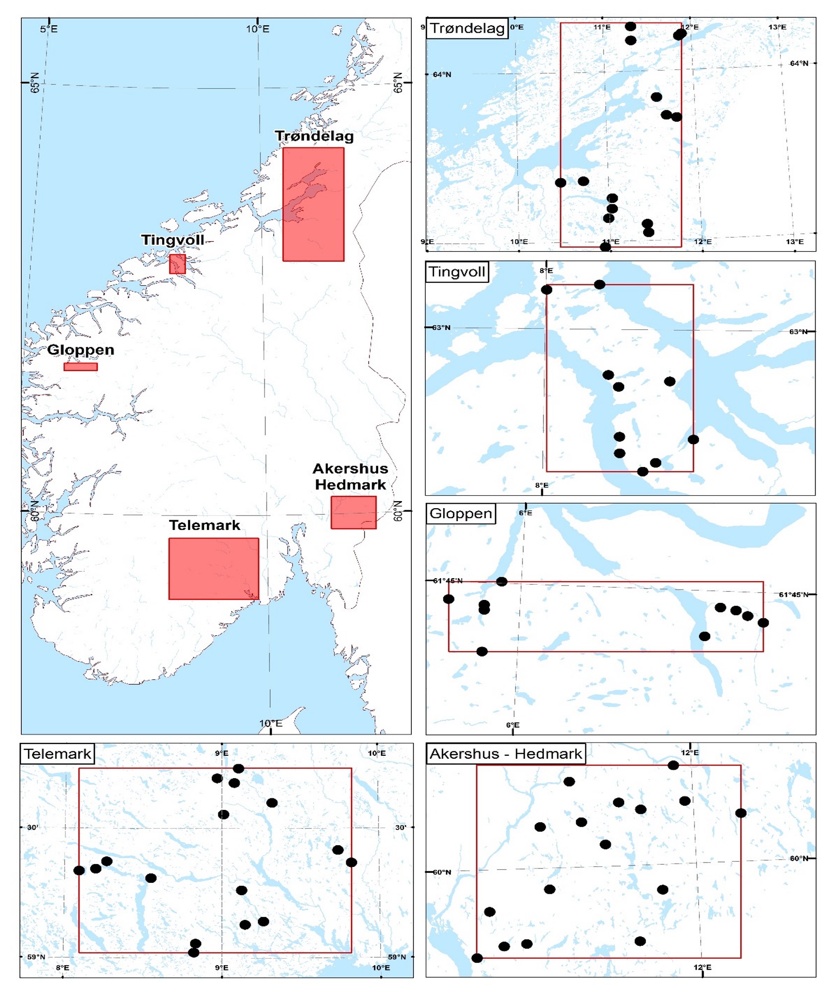
In this project we will examine environmental and societal aspects of forest ungulate browsing in boreal ecosystems within an ecosystem services framework to underpin an ecosystem approach to sustain forest resources. Replicated exclosure/browsed paired plots of 20x20 m are in place in recently clear-cut forest where moose is the dominant forest ungulate: In Trøndelag 15 sites are monitored since 2008. We investigate the impact of browsing forest ungulates on: (1) Forest development (tree growth, species composition, browsing pressure and tree density), to collect primary data relating to timber provisioning, forest ungulate production (forage availability) and ecosystem functioning. Methods: The density of trees of different species and height classes is recorded in four subplots in each exclosure/browsed plot. Individual trees are also marked and height and browsing pressure are recorded annually, producing a time series of forest development; (2) Field layer vegetation dynamics (species diversity and primary productivity, berry production) – focusing on the provisioning services of berries and wildlife forage. Methods: Field layer is recorded biennially in 10 quadrats per exclosure/browsed plot using the point intercept method
-

Mare Longue Forest is located in the South East of the island of La Réunion (French overseas, Indian Ocean) on the municipality of Saint-Philippe. It is the last remnant of lowland tropical rainforest for the Mascarene archipelago, located on a 364 year-old lava flow. The climate is warm (annual mean temperature ranges from 19 to 25 °C) and humid ( in summer reaching 90 to 95 % of relative humidity), precipitation varying between 408 mm at 130 m a.s.l to 18 000 mm at 1600 m a.s.l. Since 1958, a biological reserve of 21 ha has been established, which was then extended into a natural reserve in 1981, it is now since 2007 under the protection of the National Park of Réunion. The site is composed of a variety of forest habitats, from a primary forest with high diversity in woody plants (more than 50 species of indigenous and endemic species) and epiphytes with a 20 m canopy height, to planted forests of monospecific indigenous species, plantations of vanilla in forest, coastal vegetation. The forest of Mare Longue, in the only corridor land to sea on the island between 0 to 2600 m, with uninterrupted vegetation and where the impact of human is recent (from 1665). In the native forest 3 ha permanent plots have been monitored (MALO1 since 1990, MALO2 since 1999 and MALO3 since 2003) where all trees (> 50 000) are inventoried, tagged and measured for their diameters. A climatic station in the native forest at 250 m has been operating since 2011. In the closest town, the Research forest station of Mare Longue is welcoming researchers and students for their scientific stay on the island with all needed facilities.
-
Kilpisjärvi Biological Station is situated in the mountain birch forest zone near the 70th degree of northern latitude (69°03'N; 20°50'E) in the northwesterenmost part of Finland. The station belongs to University of Helsinki, the Faculty of Biological and Environmental sciences. The station is famous for its long-term ecological research projects (longest continuous ecological projects started already in 1946), and long-term follow-up studies form the core of the research activities. For instance, the projects were praised in the international "Research Assessment Exercise 2005" of the University of Helsinki. Data of these projects are constantly used as background information in many short-term projects, too (see Figure below). Because the station is situated in the Sámi indigenous people reindeer herding area, there are good opportunities for socioeconomic studies. Land use conflicts between different stakeholders (reindeer herding, tourism, scientific research, etc.) have already been studied.
-
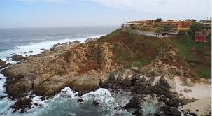
The site is a wave-exposed rocky shore typical of central-northern Chile. The coastal border (including littoral zone and intertidal shore) as well as the shallow subtidal habitat (down to about 25-30m deep) has been protected from human intervention since 1982. In 2005 the marine area was declared Area Marina Costera Protegida (AMCP) de Chile (Marine Protected Area). Adjacent to the marine reserve there is a marine laboratory, Estación Costera de Investigaciones Marinas of P. Universidad Católica de Chile.