
groundwater level
Type of resources
Available actions
Topics
Keywords
Contact for the resource
Provided by
Years
Formats
Representation types
-
The Institute of Hydrology of the Leibniz Centre for Agricultural Landscape Research (ZALF) e.V. operates 7 groundwater monitoring wells in the Quillow catchment. The wells are located in the neighborhood of Dedelow near the stream Quillow and its tributary Peege. Altitude in meter: between 64 and 74 m a.s.l., Geographic latitude: 53,3665 N, Geographic longitude: 13,8030 E. Groundwater heads are measured automatically every day (deep wells GAUGE_ID 198, 201, 203 and 204) or measured with a light plummet every 4 weeks (shallow wells GAUGE_ID 199, 200 and 202).
-
The Hyderabad Site comprises an aquifer in crystalline rocks in a weathering profile characteristic of a tropical environment. The intense anthropic pressures on groundwater resources have led to a need to develop tools for managing the resource.
-
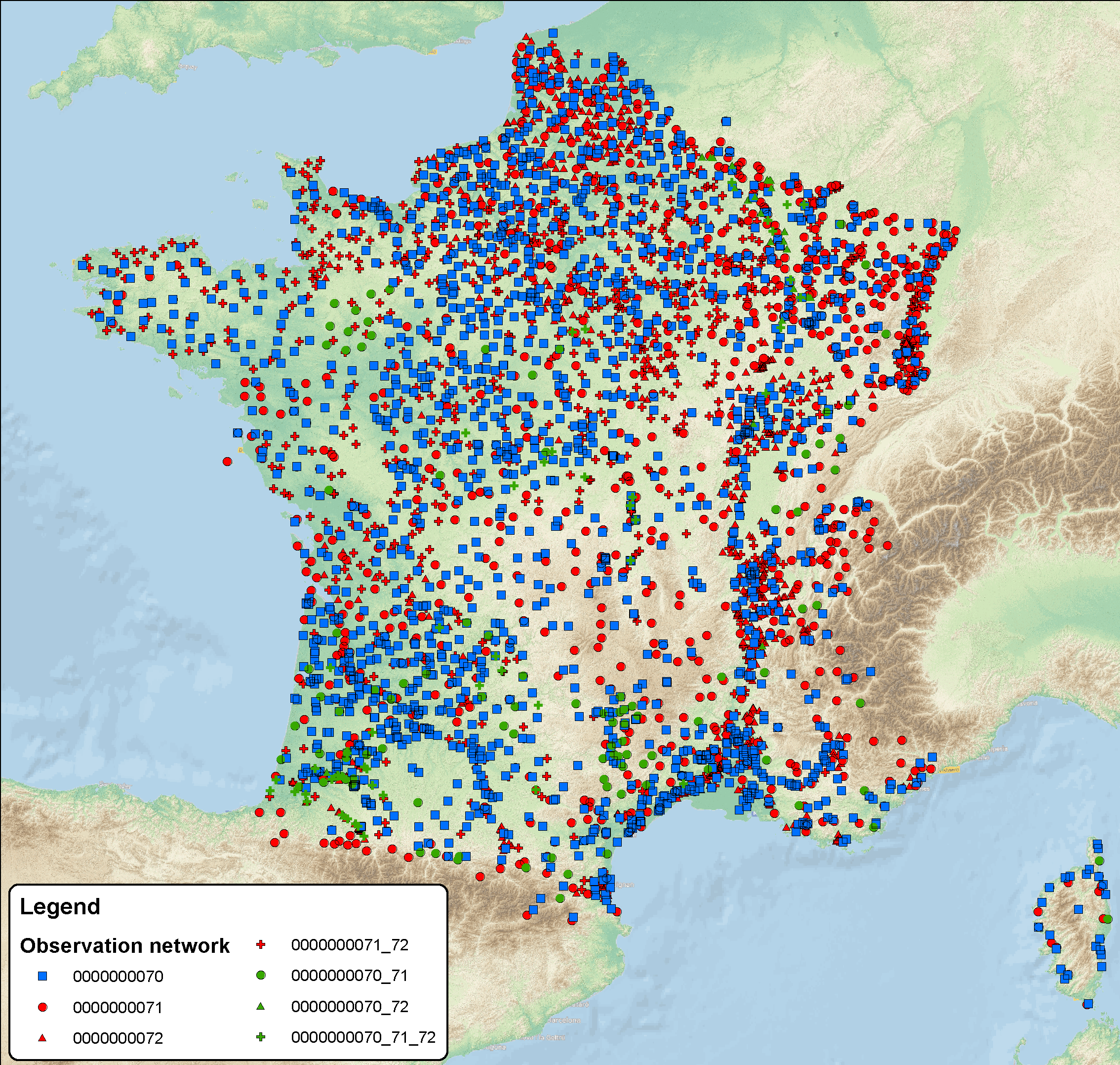
ROSES is the groundwater observatory network at national scale (France); it's based on 78 000 monitoring water points (4600 observatory boreholes and 75 000 qualitometers (wells, borholes, springs); some stations concern both measurements, quality and groundwater level). Some water points belong to water framework directive (WFD) such as groundwater level data network 0000000070, quality monitoring network 0000000071 and quality operational network 0000000072, and several other regional networks operated by various actors. Available data: More than 15 million piezometric levels, more than 78 million analyses (in situ parameters, major ions, traces, organic compound (pesticides, pharmaceutical substances, ...)) Monitoring frequencies for the chemical data are different in fonction of the pressure on the ressource (monthly to yearly). Regarding groundwater level, for the WFD observatory boreholes network, the frequency is on the hour base; in the database, daily data are only available. All ROSES' data are available on the ADES database ( www.ades.eaufrance.fr)
-
This site falls partly with the isimagaliso wetland park as well as within forestry areas on its boundary. SAEON is beuiling onf a >40 year ground water record and has added rain gauges to the site. It is a cimplimentory site to teh SAEON MCP site assessing the realtive impacts of land use land cover and climate on the ecosystem services in the area. Threats to Lake St Lucia Ramsar Site from proposed open cast mining operations in 1992 (CES, 1992) prompted a national and international outcry culminating in an international petition to “Save St Lucia” that led to its declaration as a World Heritage Site. This culminated in the proclamation and development of the iSimangaliso Wetland Park that protects the marine and coastal environments from Cape St Lucia to the Mozambique Border. The conservation policy in terms of the 1992 Conservation Development Plan was to protect a diversity of habitats such as coastal dune forests, coastal grasslands, hygrophilous grassland, coastal woodlands and shrublands. This vegetation mix would allow for the required habitat and feeding area for priority St Lucia animal species ...” (CES, 1992). Consequently, the St Lucia system, with its rich diversity of habitats, will be protected by national and international legislation for long-term global prosperity.
-
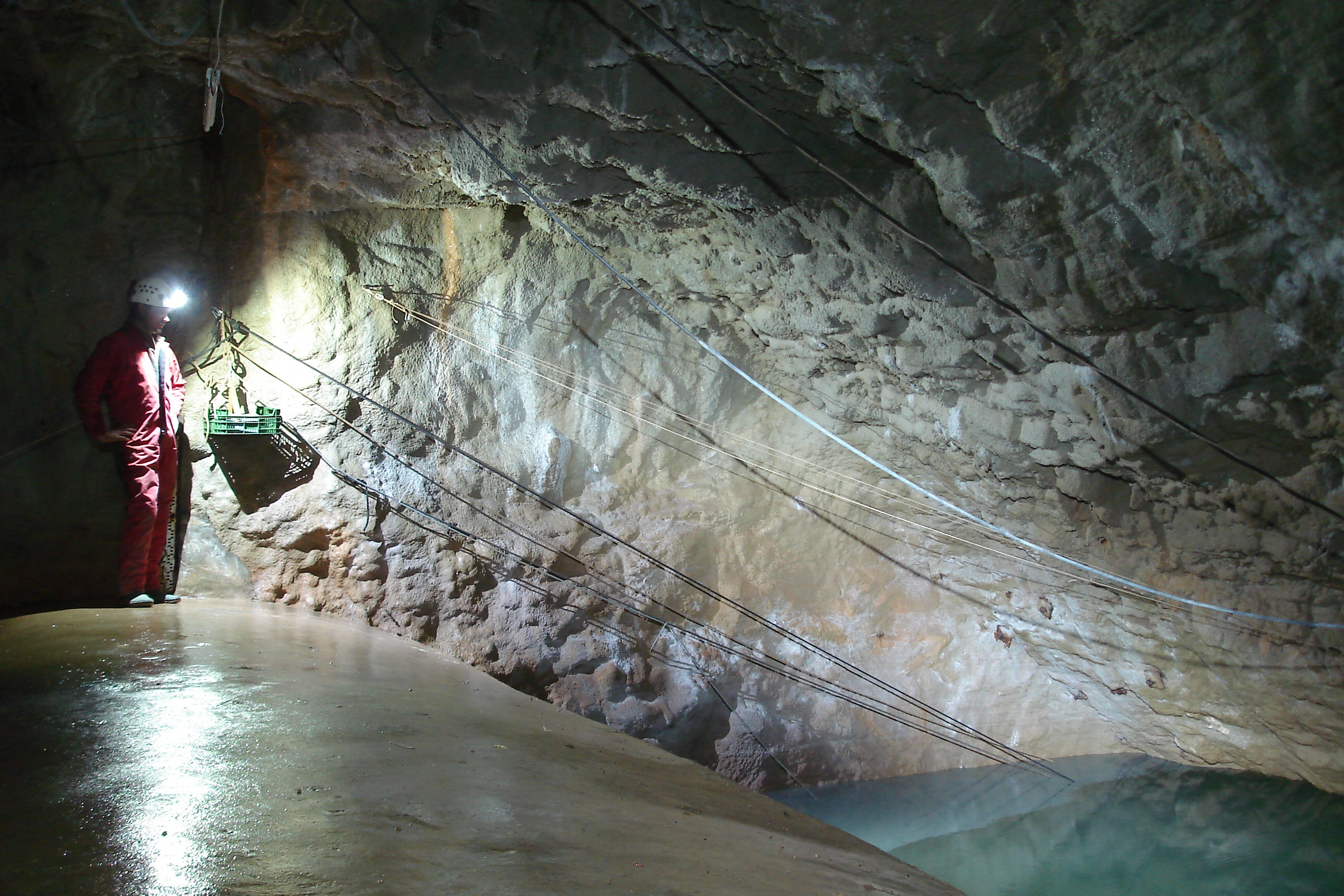
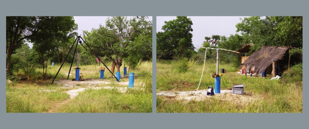
The Mediterranean and coastal site of Port-Miou is a wide regional carbonate aquifer, with a catchment area around 400 km², in south of France (Provence, France). It extends mainly over natural land, in the vicinity of one of the main city of France (Marseille), facing recent urban expansion and future groundwater resources management issues. Top of the recharge area culminates at 1100 m asl, and the main outlets are submarine springs. Karst features are observed in surface (polje, intermittent rivers, sinkholes, karren, caves) and underground. Many karst networks have been explored in the unsaturated zone of the aquifer, but also in the saturated zone below the sea level. Karst features and conduits drive the groundwater flows to the main outlets. The Port-Miou submarine springs outflow from huge flooded karst conduits, explored by cave diving over several kilometers inland, and to -235 m deep. Groundwater is brackish, polluted by seawater intrusion. The Port-Miou observation site includes flow rate, salinity and temperature monitoring at the main brackish spring, in an in-situ underground laboratory located 500 m inland from the seashore, directly in the main karst conduit. Rainfall is also recording in the catchment area, and rain water samples are collected for water isotopes observation.
-
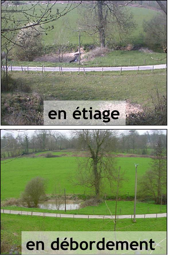
The Chalk Karst observatory groups different karst sites on the Cretaceous Chalk located at the Paris Basin (Norville, Radicatel, Yport, Saint-Martin-Le-Nœud). These karst watersheds range from 10 to 200 km2 and the land use consists of agriculture and grazing under oceanic climate. There are characterized by chalk plateaus covered with clay-with-flints owing to chalk weathering constituting a fairly impervious layer and with quaternary silts. These surficial formations range from 3 to 20 meters depth and are highly susceptible to crusting, compaction, and erosion, particularly during autumn and winter. A numerous swallow holes locally penetrates the chalk through the above-mentioned impervious layer, resulting in a strong connection of the surface with the aquifer inducing infiltration of turbidity releases at spring and well used to drinking water (up to 500 NTU). These Chalk karst sites are one the sites of the French SO-KARST labellised by INSU-CNRS and are a part of the French RBV-Network and ZA Seine.
-
In Doñana official groundwater level and recharge monitoring is done by the Guadalquivir Water Authority (Confederacion Hidrografica del Guadalquivir CHG). Levels are recorded monthly at 195 measurement points distributed throughout the whole area (unsaturated zone) with starting dates between 1974 and 1994. Additional measurements related with groundwater recharge and chemical composition, covering different periods and areas, are made by research entities. Geological and Mining Institute of Spain (IGME) installed soil moisture sensors and piezometers in the sandy soils of Doñana in 2008 and one lysimeter has been installed in 2016
-
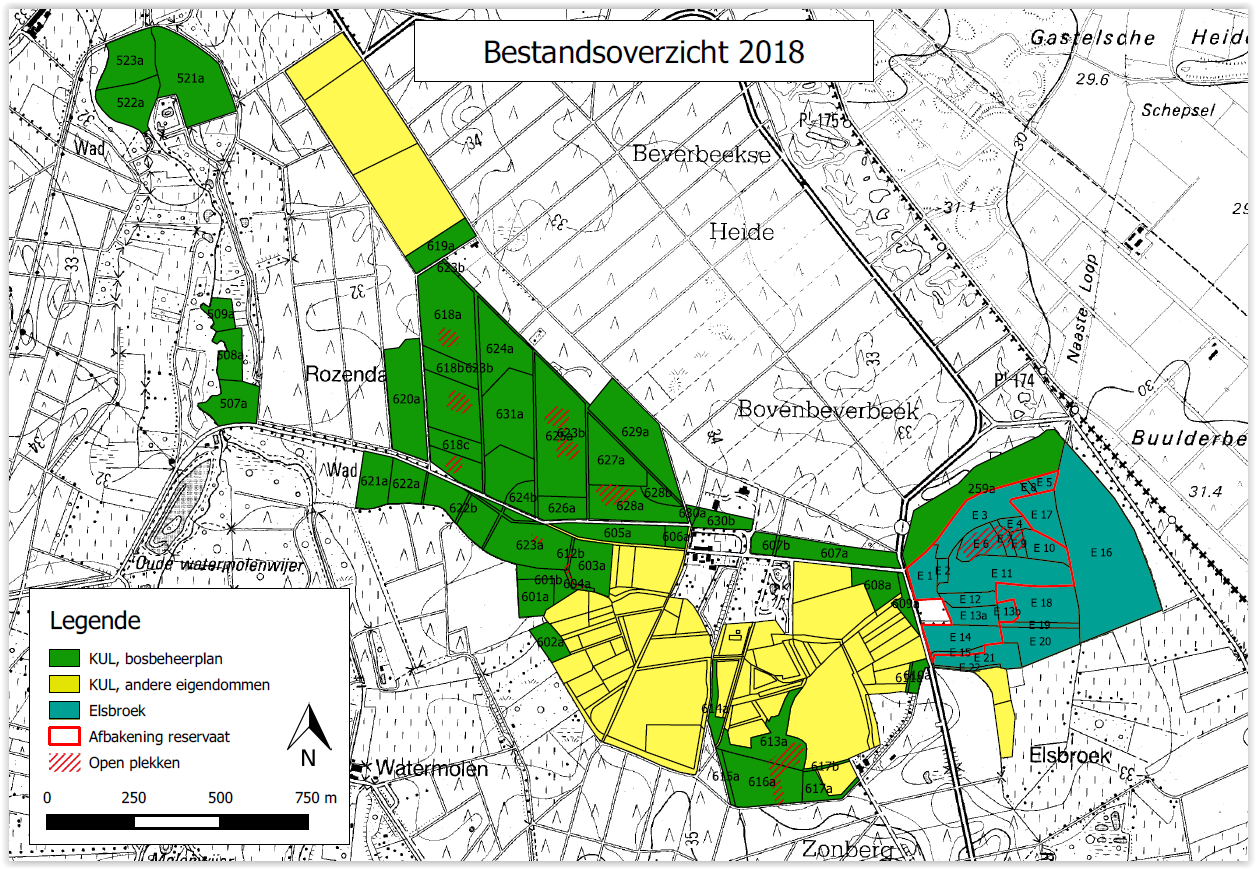
Beverbeek is a complex site consisting of areas with a primary conservation purpose as the two gazetted nature reserves Elsbroek (mesotrophic and oligotrophic mire with alder-birch woodland, Myrica bush) and Zooren (alluvial plain forest). Other parts are multifunctional forests with scots pine, corsican black pine, oak, larch, douglas fir, etc.
-
TERENO Harz - central german lowland - Hohes Holz Time series station data includes time series data for the year 2019 for the following parameter: LAI, Eddy Flux, Precipitation, Atmospheric Pressure, Relative Humidity, Air Temperature, Wind Direction, Wind Speed, incoming Long Wave Radiation, outgoing Long Wave Radiation, incoming Short Wave Radiation, outgoing Short Wave Radiation, Photosynthetic Photon Flux Density, Soil Water Content, Soil Temperature, Biomass, Groundwater Level. Please follow the method file for specific and detailed information.
-
The Galabre site is part of Draix-Bleone observatory, located in the French South Alps, upstream of Digne, on the right side of the Bleone river. The hydrosedimentary station of La Robine-sur-Galabre was created in 2008 to measure water of sediment fluxes from the Galabre catchment, 20 km2. This catchment integrates a diversity of lithologies and land use that are characteristic of the Pre-Alps. The climate is mountainous and Mediterranean. The site is characterized by intense erosion and intermittent sediment fluxes. The variables that are monitored on the long-term include rainfall and meteorology, high-frequency water discharge and suspended sediment concentration (10 minutes), some physico-chemical properties of stream water and sediments.