
habitat complexity
Type of resources
Available actions
Topics
Keywords
Contact for the resource
Provided by
Years
Formats
Representation types
-
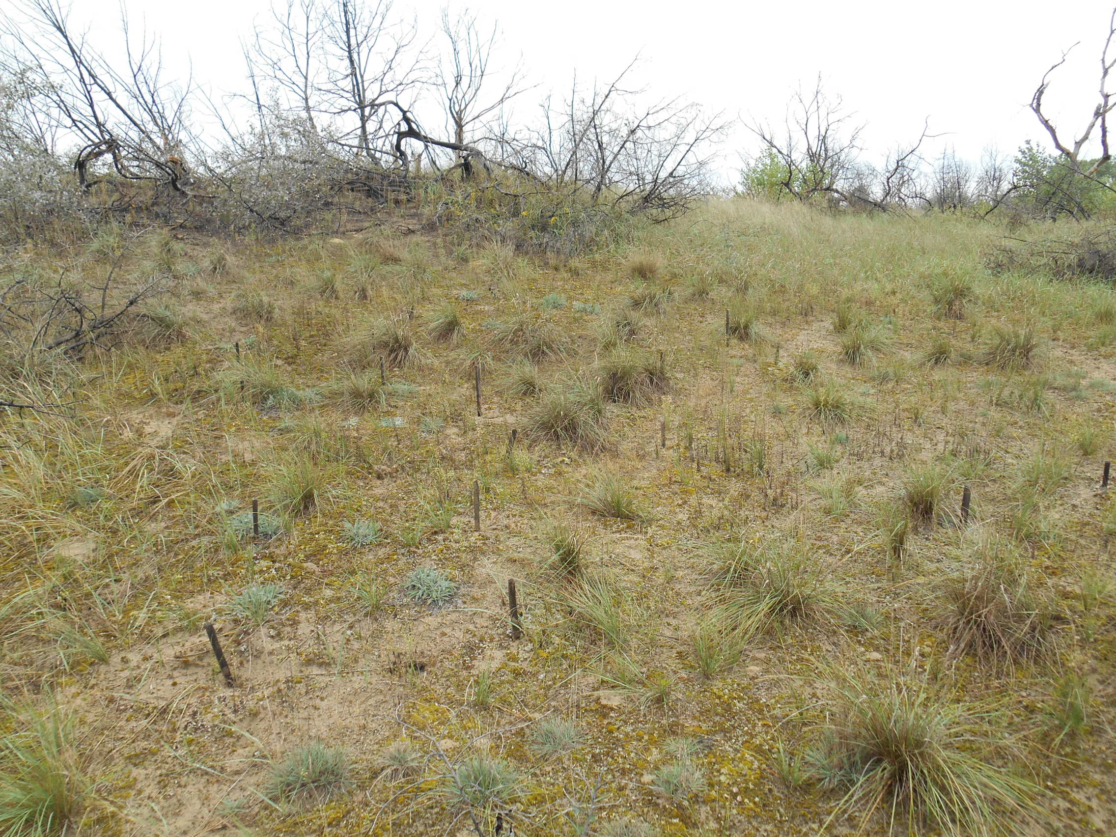
3 sites with 10 ha altogether; follow the long-term changes on sand steppe gaps of juniper-poplar forest in order to study the effect of fire
-
Studies on ecological successions have a long tradition and strongly contributed to the understanding of community assembly, niche theory and ecosystem structure and functionality. Reports on ecological successions are however mostly restricted to one or two taxonomical groups, neglecting the mutual influences and dependencies between multiple taxonomic groups that are the building blocks of multidiverse communities. We introduce the Alpine research platform Ödenwinkel to promote observational and experimental research on the emergence of multidiversity and ecosystem complexity. We established n = 140 permanent plots along the successional gradient of the forefield of the Ödenwinkelkees glacier at the end of Stubachvalley in the Hohe Tauern range (National Park Hohe Tauern, Land Salzburg, Austria). In summer 2019 we completed a first full inventory of biotic and abiotic characteristics of these plots covering the diversity and composition of vascular plants, bryophytes, arthropods and other animals, bacteria and fungi as well as some geomorphologic properties. In this paper we introduce the design of the research platform and show first results on the diversity and composition of vascular plants along the successional gradient. The Ödenwinkel platform will be available as long-term ecological research site where researchers from various disciplines can contribute to accumulate knowledge on ecological successions and on how interactions between various taxonomical groups structure ecological complexity in this alpine environment.
-
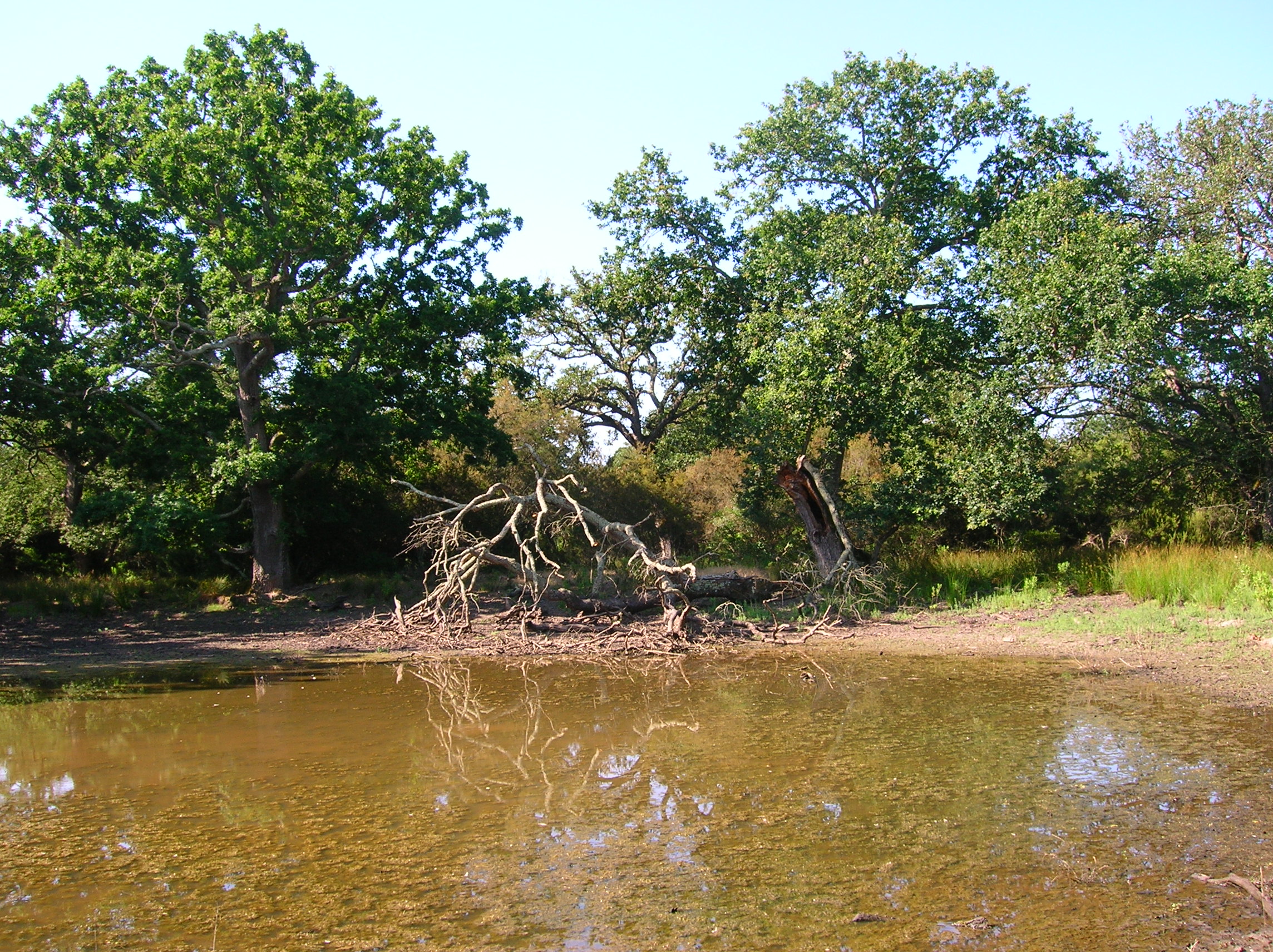
The Presidential Estate of Castelporziano stretches itself over an area of about 6100 ha and is located approximately 24 km from the city of Rome. The territory is characterized by remarkable natural features. It shows most of the typical Mediterranean ecosystems (relict strips of lowland forest with hygrophilous vegetation, deciduous and evergreen mixed oak woods, Mediterranean scrub, dune vegetation). Until recently (2019), there were large surfaces of stone pine unfortunately destroyed by the combined action of alien pest Toumeyella parvicornis with Tomicus destruens, the main pest of Mediterranean pine forests. Inside the Estate, there are two Special Areas of Conservation (SACs): one concerning the coastal strip (IT6030027) and the other one concerning hygrophulous oak-woods (IT6030028). In addition to including the two SACs, the Estate is in its entirety Special Protection Area (SPA - IT 6030084). From a botanical point of view this area, together with the neighbouring Castelfusano territory, represents what remains of the vast forest system that covered the entire delta of the Tiber and the surrounding areas. The land is mostly flat, but in the North there are modest reliefs that are not higher than 85 m. on sea level. A complex set of ancient dunes and a chain of more recent dunes stretch out along the coastline. There are many temporary and permanent natural pools and wetland areas with seasonal floodings caused by meteoric water and groundwater, which usually dry out during summer and represent sites with the greatest biodiversity. From an ecological point of view, those “relict wetland areas” play actually a very important role for biodiversity because of plant species which are typical of hydrosoil and in the past were widespread but have now almost disappeared.
-
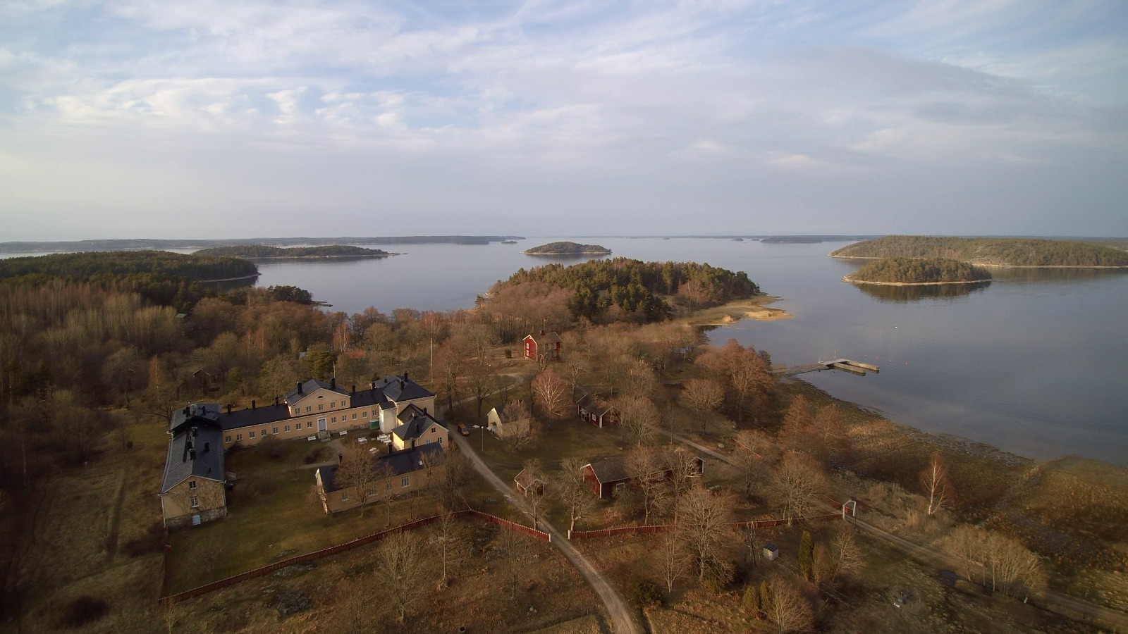
The Archipelago Research Institute is a historical marine station at the island of Seili, located in the middle of the Turku archipelago. The Institute offers various research support services as well as participates in multidisciplinary research of the Baltic Sea, with a special focus on the condition of the Archipelago Sea. The station is open for researchers and visitors year-round.
-
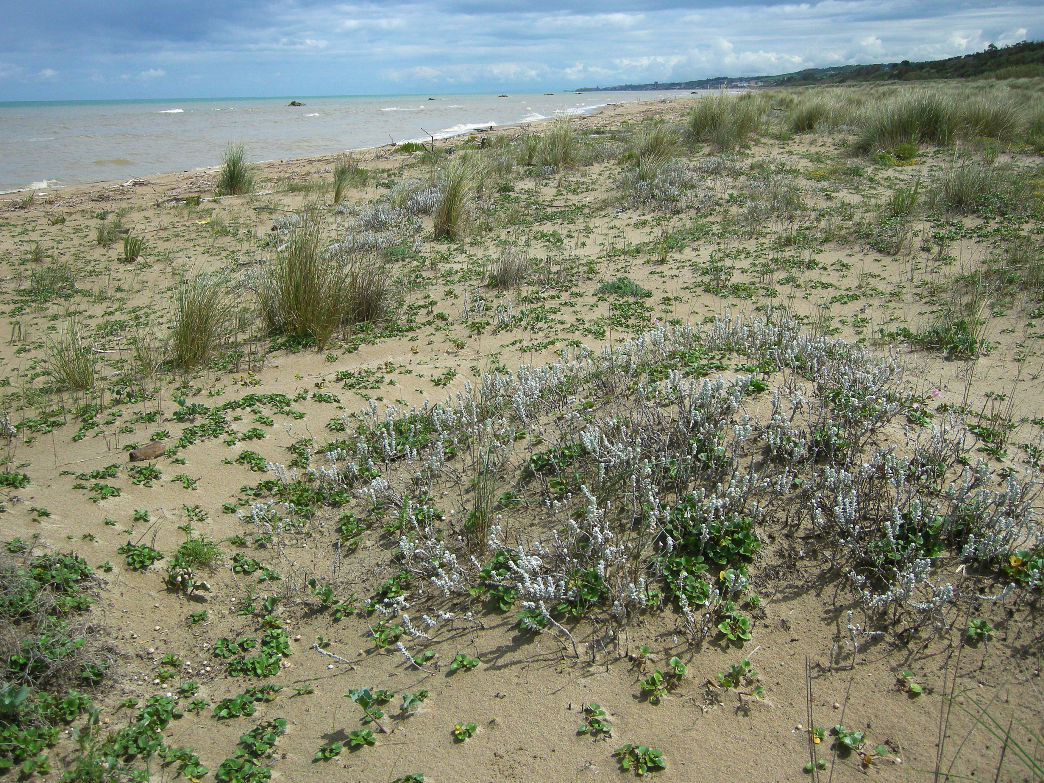
S.C.I IT7228221 Foce Trigno-Marina di Petacciato (Campobasso) S.C.I. IT7140108 Punta Aderci-Punta della Penna S.C.I. IT7140109 Marina di Vasto The site includes 3 Natura 2000 sites along the central Adriatic coast, where the last fragments of natural vegetation zonation on sand coastal dunes occur (shore vegetation, embryo and mobile dune vegetation, annual Mediterranean grasses and wet dune slacks).
-
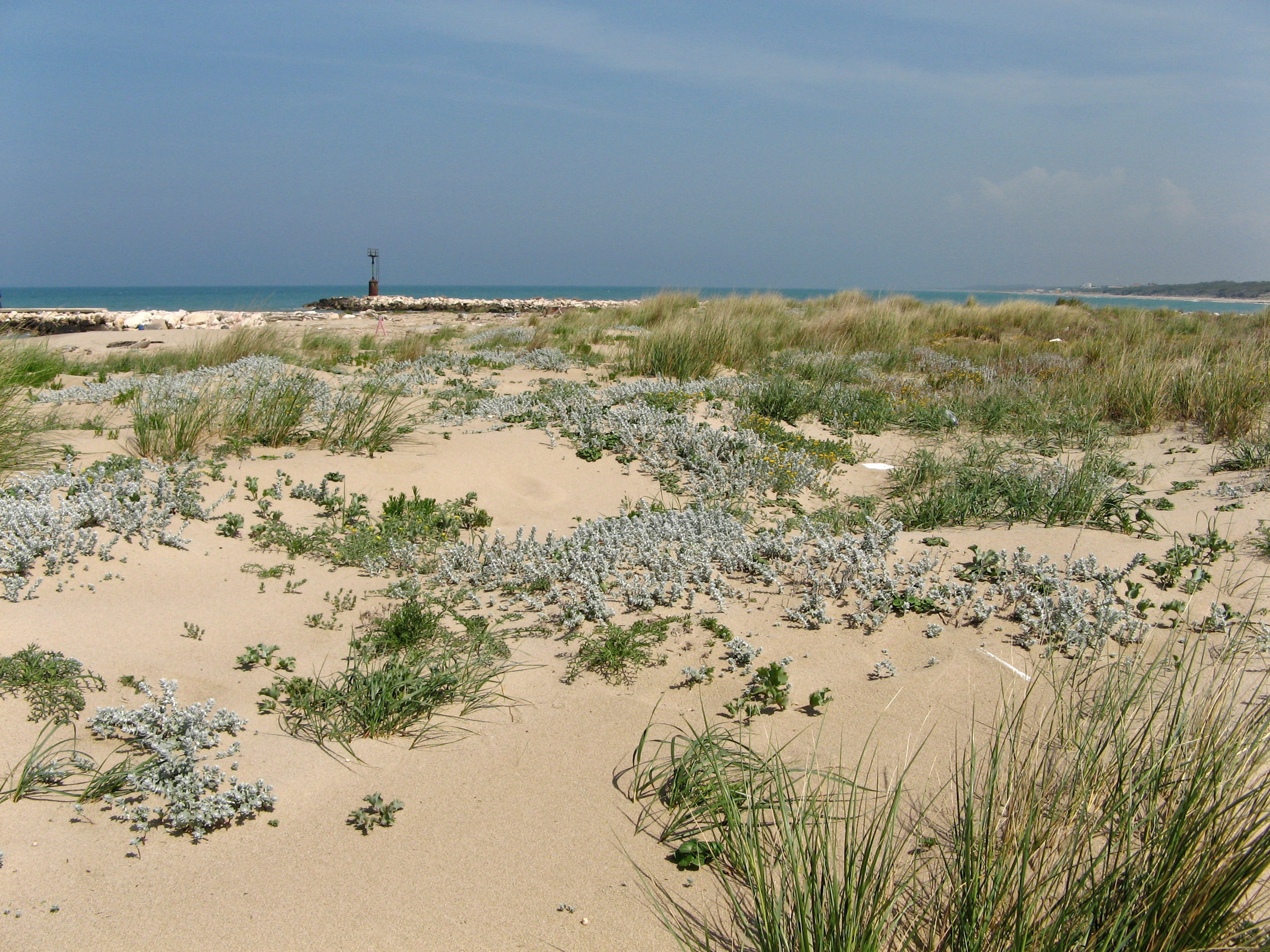
SCI IT7222217 Foce Saccione-Bonifica Ramitelli (Campobasso) The site includes 1 Natura 2000 site along the central Adriatic coast, where the last fragments of natural vegetation zonation on sand coastal dunes occur (shore vegetation, embryo and mobile dune vegetation, annual Mediterranean grasses, costa dunes with Juniperus spp and wet dune slacks).
-

The Seine estuary is a megatidal estuary located in northern France. It is the third largest estuarine ecosystem in the country after the Gironde and Loire along the French Atlantic coast; its waters flow into the English Channel. The geographical zone of influence of the Seine estuary runs from just upstream of the Poses dam, at the limit of the tidal penetration into the estuary — 160 km upstream of Le Havre —to the eastern part of the Bay of Seine. It can be divided into three sections: the fresh water upstream section (125 km), the mixing zone characterized by varying salinity levels (35 km), and the marine downstream section under the influence of the Seine River. The megatidal regime generates a turbidity maximum in the mixing zone (middle estuary) between the marine and fluvial sections of the estuary. The Seine estuary is a typical estuarine ecosystem: highly stressed by natural fluctuations and anthropogenic pressures, and hosting a rich ecological system. The Seine valley and its estuary are of major economic importance for France, with the presence of two maritime ports. It’s watershed (79,000 km2) is the home to 17 million people, and accounts for 50 % of the river traffic in France, 40 % of the country's economic activity, and 30 % of its agricultural activities. In addition to the Greater Paris area (> 11 million inhabitants), which contributes heavily to the Seine estuary's upstream inputs, two other major river settlements — Rouen (500,000 inhabitants) and Le Havre (300,000 inhabitants) — are maritime ports of international importance. Due to economic development, the Seine estuary has been subjected to major hydrodynamic, ecological, biogeomorphological and biogeochemical changes. The importance of studying the effects of anthropogenic impacts on estuarine ecosystems has increased in the last decade, especially under the Water Framework Directive, which aims to achieve “good environmental status” of all European water bodies.
-
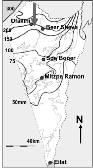
Designation: Ecosystem research and management under land-use and climate change. Climate: Mean annual precipitation 150-200mm between November and April; mean maximum summer temperature 34° C, mean minimum winter temperature 6° C. (Data avialable for 15-min interval meteorological measurements and daily summaries for rainfall, air and soil humidity and temperature, wind velocity and direction, from 1997 to the present.) Principal biomes: Semiarid shrub land (shrub-grass steppe), rocky and loessial watersheds, ephemeral streams. Vegetation is dominated by patch-forming dwarf shrubs (Noaea mucronata, Atractylis serratuloides and Thymelea hirsuta) with species-rich annual winter vegetation in the inter shrub (dominated by Stipa capensis and other grasses) and shrub patch understory (dominated by Anagallis arvensis and other forbs). As a result of drought there are also two new sub biomes: crust land and grass land. Management: Livestock grazing excluded in central watershed (20 ha) since 1987; restricted/controlled grazing by Bedouin sheep herds in surroundings; in the outer parts of the area native and exotic trees were planted in 1985-87 in contour dykes (‘shikhim’) on the slopes and in terraces in the riverbed. Research: 1. Long-term experiments (up to 20 years) for monitoring changes in abundance, diversity, species composition and distribution, and development of biological soil crusts (BSC), perennial plants (dwarf shrubs) and winter annuals in relation to rainfall, soil disturbance, patch distribution, and livestock grazing. 2. long term hydrological studies on rainfall-runoff relationship under natural and manipulation experiments. 3. Short-term experiments and surveys (1 to 5 years) A. for testing hypotheses about the detailed processes, mechanisms and interactions involved in the development, dynamics and stability of shrub- and BSC-dominated patches, their landscape mosaic patterns and their feed-back relationships with flows of materials through the landscape; B. for testing hypothesis on the effect of geodiversity on the stability of shrub land to extreme drought and understanding state changes in drylands. 4. Long term studies on cross scale-cross level interactions in natural and human modified landscape. 5. Network-related research including regional comparisons of herbaceous plant productivity in open rangeland along the Israeli North-South rainfall gradient, and global comparison of woody plant diversity effects on ecosystem functionality of most dryland regions of the world.
-
The LTSER Zone Atelier Brest Iroise, created in 2012, is located in Brittany, NW-France. It aims at understanding the functioning and the long-term dynamics of the social-ecological system located along the land-ocean continuum. It combines work along different gradients and at different interfaces: between Earth compartments (sediment-water-atmosphere, land-ocean), tools (observation, experimentation, modeling), disciplines (especially between natural and human and social sciences) and between science and society. About half of the area (3000 km2) is terrestrial, including the watersheds of the Elorn (280 km2, 285,000 inhabitants mostly in the Brest area) and the Aulne (1820 km2, 70,000 inhabitants) rivers which are characterized by intensive agricultural practices. The Bay of Brest is a semi-enclosed coastal Bay, with an area of 180 km2. Part of this Bay and of the Aulne estuary is a Natura 2000 site, operated by the “Parc Naturel Regional d’Armorique” (PNRA). The marine part (3550 km2) of this land-ocean continuum is the Iroise Sea, comprising beaches, the continental shelf, the Sein Island and the Molène-Ouessant archipelago. This area corresponds to the limits of the first marine natural protected area created in France in 2007 (the “Parc Naturel Marin d’Iroise”, PNMI). This area presents exceptional natural and human heritage, including a rich marine biodiversity, human traditions and emblematic activities (e.g. great Scallop fishing).
-

Historically, the role of the Galapagos Islands has been considered critical due to the evolutionary diversification induced by natural and historical isolation. The Galapagos National Park was established in 1959, based on its historical importance associated with Charles Darwin's voyage and its rare and endemic biodiversity, composed of unique vertebrate and plant communities (Rozzi et al. 2010). In 1978, the Galapagos Islands were declared a UNESCO World Heritage Site, a critical factor associated with this national park (Rozzi et al. 2010). The Galapagos Islands are a pristine area with local and regional climates influenced by the interaction of ocean currents and winds driven by the Inter-Tropical Convergence Zone; ITCZ (Conroy et al. 2008, Trueman and d'Ozouville 2010). The long-term programme includes forty natural aquatic ecosystems (lakes, ponds, lagoons and swamps) that will be sampled on the islands of San Cristobal, Santa Cruz, Isabela and Floreana, where possible along a lowland-highland gradient. The number of sampling points will vary according to environmental heterogeneity and the presence of a littoral region, among other factors.