
habitat structure
Type of resources
Available actions
Topics
Keywords
Contact for the resource
Provided by
Years
Formats
Representation types
-
In 1998 a permanent plot (50 x 50 m) was established at the height of 440 m asl in 80 year old spruce stand, where bulk deposition, throughfall and soil solution are collected. The investigations of health status of trees and floral characteristic have been carried out since 2001. The analyses are carried out in a certified laboratory of the Institute for Ecology of Industrial Areas, Katowice (Certificate No AB 325). The basic meteo data are taken from the monitoring station located 1 km from the plot).
-
In 1998 a permanent plot (50 x 50 m) was established at the height of 505 m asl in 45 year old spruce stand, where in the 45-year-old spruce stand bulk deposition, throughfall and soil solution are collected. The investigations of health status of trees and floral characteristic have been carried out since 2001. The analyses are carried out in a certified laboratory of the Institute for Ecology of Industrial Areas, Katowice (Certificate No AB 325). The basic meteo data are taken from the monitoring station located about 1 kn from the plot.
-
In 1998 a permanent plot (50 x 50 m) was established at the height of 780 m asl in 100 year old spruce stand, where bulk deposition, throughfall and soil solution are collected. The investigations of health status of trees and floral characteristic have been carried out since 2001. The analyses are carried out in a certified laboratory of the Institute for Ecology of Industrial Areas, Katowice (Certificate No AB 325). The basic meteo data are taken from the monitoring station located about 1 kn from the plot.
-
In 1998 a permanent plot (50 x 50 m) was established at the height of 718 m asl in 70 year old spruce stand, where bulk deposition, throughfall and soil solution are collected. The investigations of health status of trees and floral characteristic have been carried out since 2001. The analyses are carried out in a certified laboratory of the Institute for Ecology of Industrial Areas, Katowice (Certificate No AB 325). The basic meteo data are taken from the monitoring station located about 1 km from the plot.
-
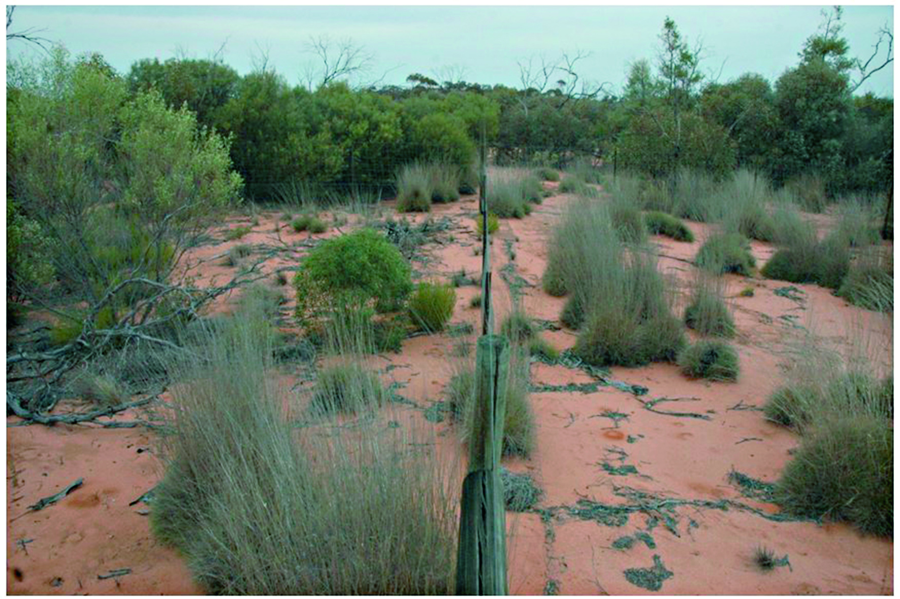
The Mallee Plot Network is located in the red aeolian sand dunefield landscape of the Scotia district within Tarawi Nature Reserve, Scotia Wildlife Sanctuary and Danggali Conservation Park in south-western New South Wales and adjacent areas of South Australia. The study area sits on the south-eastern edge of the Australian arid zone and is close to the arid limits of distribution of the mallee woodland biome, which stretches across the temperate semiarid belt of southern Australia (Noble 1984). Mallee woodlands typically occur in regions In the Scotia district and its surrounding region, mallee woodlands occur within a landscape mosaic that includes patches of woodland dominated by Casuarina pauper (belah) and shrublands dominated by Maireana sedifolia and M. pyramidata (bluebush) (Westbrooke et al. 1998). These latter vegetation types occur on gently undulating sandplains with a calcareous crust not far below the soil surface. In contrast, mallee woodlands dominate transverse east–west oriented dunefields. The dunes are characterised by deep, red sandy loams dominated by Eucalyptus socialis (pointed mallee), E. dumosa and E. costata—occasionally with Callitris verrucosa - with a mixed understorey of hummock grasses and shrubs, and a largely ephemeral ground layer of tussock grasses and forbs. The intervening swales have finer-textured red loams and generally support a wider range of eucalypts including E. oleosa and E. gracilis, but C. verrucosa is absent. Their understoreys typically include a higher density and diversity of shrubs but lack hummock grasses, and the ground layer is typically sparse. Detailed descriptions of vegetation and landscapes are included in Westbrooke et al. (1998). Temporal visits were initially staggered, then annual for 3 years and is now decadal. Between 2012 and 2018 the Mallee Plot Network was a member of Long Term Ecological Research Network (LTERN), Australia, a facility of the Australian Government's Terrestrial Ecosystem Research Network (TERN)..
-
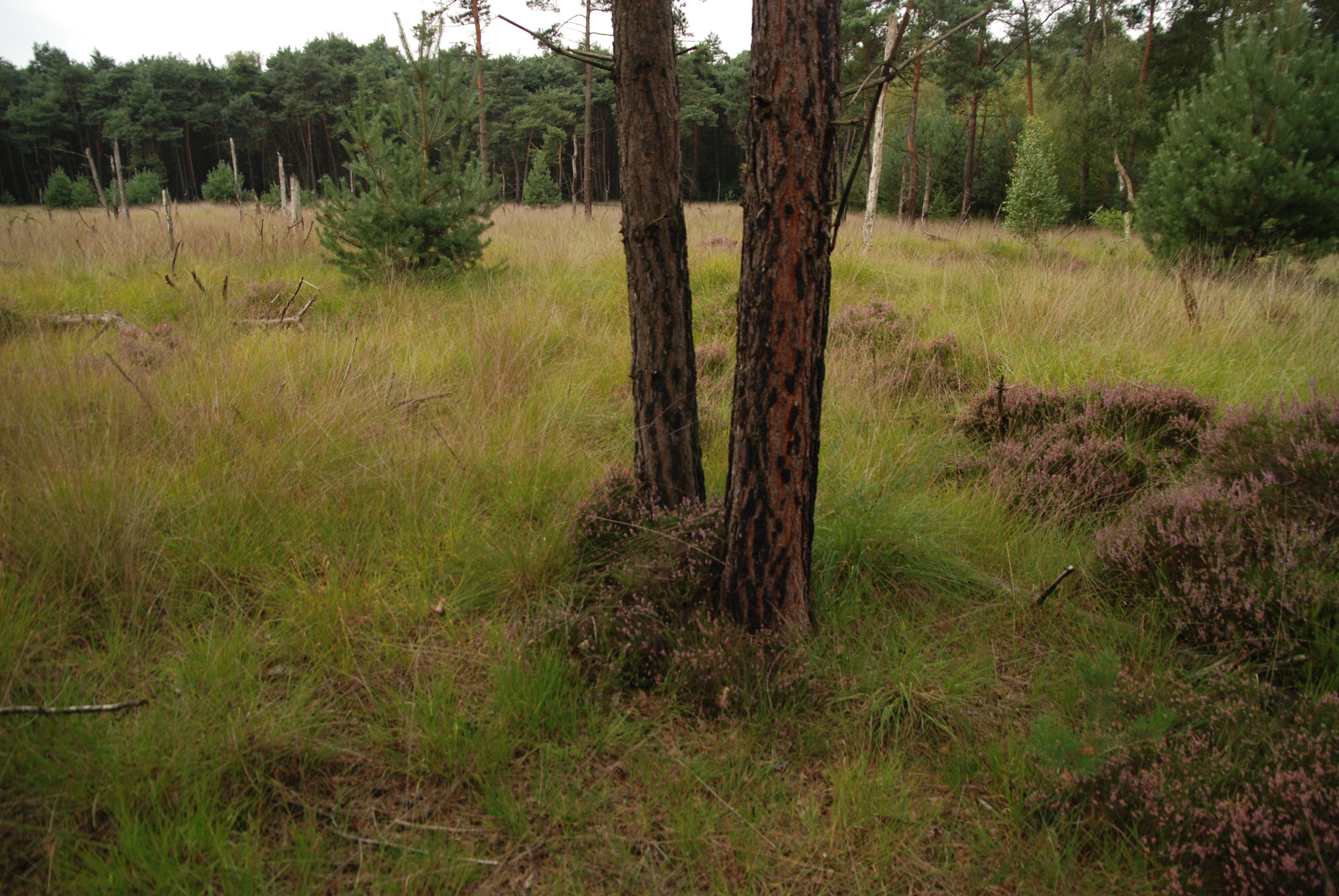
heathland and inland dunes with conifer forest, including a strict forest reserve (Withoefse heide - monitoring since 1975)
-
In 1998 a permanent plot (50 x 50 m) was established at the height of 238 m asl in 70 year old spruce stand, where bulk deposition, throughfall and soil solution are collected. The investigations of health status of trees and floral characteristic have been carried out since 2001. The analyses are carried out in a certified laboratory of the Institute for Ecology of Industrial Areas, Katowice (Certificate No AB 325). The basic meteo data are taken from the monitoring station located 1 km from the plot).
-
In 1998 a permanent plot (50 x 50 m) was established at the height of 685 m asl in 60 year old spruce stand, where bulk deposition, throughfall and soil solution are collected. The investigations of health status of trees and floral characteristic have been carried out since 2001. The analyses are carried out in a certified laboratory of the Institute for Ecology of Industrial Areas, Katowice (Certificate No AB 325). The basic meteo data are taken from the monitoring station located 1 km from the plot.
-
The European nature information system, EUNIS, brings together European data from several databases and organisations into three interlinked modules on sites, species and habitat types. The EUNIS information system is part of the European Biodiversity data centre (BDC) and it is a contribution to the knowledge base for implementing the EU and global biodiversity strategies and the 7th Environmental Action Programme. The EUNIS information system provides access to the publicly available data in the EUNIS database. The information includes: (Data on species, habitat types and designated sites compiled in the framework of Natura 2000 (EU Habitats and Birds Directives); the EUNIS habitat classification; data from material compiled by the European Topic Centre of Biological Diversity; Information on species, habitat types and designated sites mentioned in relevant international conventions and in the IUCN Red Lists; Specific data collected in the framework of the EEA's reporting activities, which also constitute a core set of data to be updated periodically, e.g. Eionet priority dataflow Nationally designated areas (CDDA)).
-
The monitoring site was established in 1993 and consists of a monitoring station, where the measuring equipment is located, i.e., Wind Speed Meter (Young) pyranometer (LiCo) hygrometers, etc., permanent plots in the 105-year-old spruce stands where bulk deposition, throughfall and soil solution are collected on the monthly basis. The investigations of health status of trees and floral characteristic have been carried out since 1994. The analyses are carried out in a certified laboratory of the Institute for Ecology of Industrial Areas, Katowice (Certificate No AB 325).