
heat flux
Type of resources
Available actions
Topics
Keywords
Contact for the resource
Provided by
Years
Formats
Representation types
-
This dataset contains time series of turbulent exchange of CO2, heat, momentum, O3 and particles measured at two heights at SMEAR II research station near Hyytiälä Forestry Field Station, Juupajoki, Finland, during years 1997–2018. The flux measurements were done with several measurement setups above the forest and at 3 m height below the canopy.
-
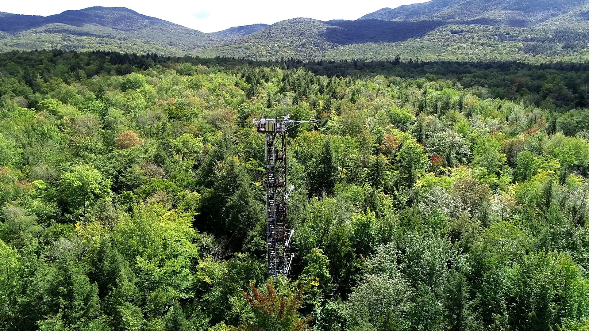
The Bartlett Experimental Forest is relocateable site in Domain 01 Northeast and the site is part of NEON's sampling design. The site is located in New Hampshire. BART extends from the village of Bartlett in the Saco River valley at 680 ft to about 3,000 ft at its upper reaches. Aspects across the forest are primarily north and east. This particular site was chosen because it represented conditions (soils, elevation, climate, tree species composition) typical of many forested areas throughout New England and northern New York. An actively managed forest: manged protions (30% reflect a range of forest patch sizes and structural distrubutions. Sampling area is 15.66 km^2. . Airborne remote sensing surveys of this field site collect collect lidar, spectrometer and high-resolution RGB camera data. The flux/meterological tower at this site is 116’ with 6 measurement levels. The tower top extends above the vegetation canopy to allow sensors mounted at the top and along the tower to capture the full profile of atmospheric conditions from the top of the vegetation canopy to the ground. The tower collects physical and chemical properties of atmosphere-related processes, such as humidity, wind, and net ecosystem gas exchange. Precipitation data are collected by a tipping bucket at the top of the tower and a series of throughfalls located in the soil array. This site has five soil plots placed in an array within the airshed of the flux tower. Field ecologists collect the following types of observational data at this site: Terrestrial organisms (birds, ground beetles, mosquitoes, plants, small mammals, soil microbes, ticks), Biogeochemical data, and and soil data. Total data products collected at this site is 116.
-
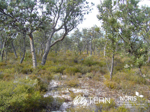
Gingin Banksia Woodland SuperSite is located on the Swan Coastal Plain, approximately 10 km southwest of Gingin, near Perth, Western Australia, sited on land traditionally owned by the Yued group of the Noongar people. The site has an elevation of 51 m and 2 km from the University of Western Australia International Gravity Wave Observatory. The Gingin Banksia Woodland SuperSite is located in a natural woodland of high species diversity (overstorey dominated by Banksia spp.) that overlays the Gnangara groundwater mound, Perth’s most important groundwater resource. The mean annual precipitation is 641mm for this coastal heath woodland. The overstorey is dominated by Banksia spp. mainly B. menziesii, B. attenuata, and B. grandis with a height of around 7 m and leaf area index of about 0.8. There are occasional stands of eucalypts and acacia that reach to 10 m and have a denser foliage cover. There are many former wetlands dotted around the woodland, most of which were inundated all winter and some had permanent water 30 years ago. The water table has now fallen below the base of these systems and they are disconnected and are no longer permanently wet. The fine sediments, sometimes diatomaceous, hold water and they have perched water tables each winter. There is a natural progression of species accompanying this process as they gradually become more dominated by more xeric species. The soils are mainly Podosol sands, with low moisture holding capacity. Field capacity typically about 8 to 10%, and in summer these generally hold less than 2% moisture. The water table is at about 8.5 m below the surface, and a WA Dept of water long-term monitoring piezometer is near the base of the OzFlux tower. The Swan Coastal Plain bioregion consists of five main geomorphic entities that are roughly located parallel to the coastline including three coastal sand dune systems with ages increasing inland from the coast. Banksia Woodlands is restricted to the Swan Coastal Plain IBRA bioregion and immediately adjacent areas, including the Dandaragan plateau. Vegetation consists of a prominent tree layer of Banksia with scattered eucalypts and other tree species present within or emerging above the Banksia canopy, and a diverse understorey including sclerophyllous shrubs, graminoids and forbs. The Gingin SuperSite is collocated with the Land Ecosystem Atmosphere Program (LEAP) - Gingin. The traditional owners at Gingin are the Yued group of the Noongar People.
-
The NEON site at the Oak Ridge National Laboratory (ORNL) is a 138.1-km^2 core terrestrial field site located in the Cumberland Plateau within Anderson and Roane Counties, TN. It is encompassed within NEON's Appalachians and Cumberland Plateau Domain 7, which includes the worlds longest expanse of hardwood-forested plateau. This domain is home to some of North America's greatest diversity of fish, mollusk, and wildflower species. ORNL is managed by a combination of the Department of Energy (DOE) and Tennessee Wildlife Resources Agency (TWRA). The Domain hosts four other NEON field sites, two aquatic and two terrestrial, three of which are located in Tennessee. Remote sensing surveys of this field site collect lidar, spectrometer and high-resolution RGB camera data. The flux/meteorological tower at this site is 127 with 6 measurement levels. The tower top extends above the vegetation canopy to allow sensors mounted at the top and along the tower to capture the full profile of atmospheric conditions from the top of the vegetation canopy to the ground. The tower collects physical and chemical properties of atmosphere-related processes, such as humidity, wind, and net ecosystem gas exchange. Precipitation data are collected by a tipping bucket at the top of the tower and a series of throughfalls located in the soil array. This site has five soil plots placed in an array within the airshed of the flux tower. Field ecologists collect the following types of observational data at this site: Terrestrial organisms (birds, ground beetles, mosquitoes, plants, small mammals, soil microbes, ticks), Biogeochemical data, and soil data. Total data products planned for this site: 119
-
McDiffett Creek (MCDI) is located within the Urban Prairie Research Area approximately 25 km southeast of the KONZ tower. [2] It is a second-order perennial stream flowing through the middle of agricultural land. The Urban Prairie Research Area is a small tract of land composed of native prairie, grazing, hay, and historically cultivated fields. It is managed by the Konza Prairie Biological Station in association with Kansas State University and is located in the Flint Hills region of Kansas just 10km south of Manhattan, KS. The MCDI site is encompassed in the NEON Prairie Peninsula Domain, which includes the largest remaining areas of unplowed tallgrass prairie in North America. The Prairie Peninsula domain consists of grasslands, forests, and agricultural cover types. The Domain hosts four other NEON field sites, one other aquatic and three terrestrial, all of which are located in Kansas. Remote sensing surveys of this site collect lidar, spectrometer and high resolution RGB camera data. This site has one meteorological station located in the riparian area. The met station is outfitted with a subset of the same sensors used at terrestrial sites. Measurements include wind speed and direction, air temperature, barometric pressure, relative humidity, shortwave radiation, and PAR. This site has one phenocam near the stream. This site has one upstream sensor station and one downstream sensor station. Measurements include PAR, temperature, water quality [specific conductivity, chlorophyll a, dissolved oxygen content, pH, turbidity, and fluorescent dissolved organic matter (only downstream)], and nitrate is measured at the downstream station. Eight groundwater wells throughout the site collect specific conductivity, water tempertaure, and elevation of groundwater.Field ecologists collect the following types of observational data at this site: aquatic organisms (Aquatic Microbes (surface water),macroinvertebrates microalgae, plants and macroalgae, zooplankton. Biogeochemical data on plants,sediment water and particulates.As well as physical aquatic data on bathymetric maps, stage,secchi depth and depth profiles, and riparian assessment. Total data products planned for this site: 79
-
The Boyagin Wandoo Woodland SuperSite was established in September 2017 by the University of Western Australia. Located in the Boyagin Nature Reserve, approximately 12 km west of Pingelly, Western Australia the SuperSite monitoring activities complement the Avon River Catchment Critical Zone Observatory at the UWA Future Farm in Pingelly that focusses on managed landscapes (rotational dryland wheat cropping and grazing pastures for sheep). The climate is Semi-arid (Dry) Warm Mediterranean. The Boyagin SuperSite is collocated with the Land Ecosystem Atmosphere Program (LEAP) - Boyagin. Boyagin SuperSite is located in the Avon Wheatbelt (AW2-Re-juvenated Drainage subregion) and has a high density of rare and geographically restricted flora and supports populations of several marsupials subject to fox predation (Numbat, Quenda, Woylie, Tammar, Red-tailed Phascogale, Brushtail Possum) that have disappeared from most of the Australian or Western Australian mainland. The Noongar people are the traditional owners at Boyagin.
-
The Lyndon B. Johnson National grasslands (CLBJ) is a core terrestrial within NEON's Domain 7: Southern Plains. CLBJ is located in the Great Plains region of north-central Texas, about an hour drive from the Dallas-Fort Worth metroplex. LBJ occupies approximately 20,000+ acres of public lands managed by the U.S. Forest Service. The grasslands are home to Black Creek Lake, which hosts an established recreation site consisting of seven picnic units, seven walk-in camp units, one improved boat ramp and an accessible fishing bridge. There are nearly 75 miles of established trails on site great for hiking, mountain biking, horseback riding, photography, and wildlife viewing. Remote sensing surveys of this field site collect lidar, spectrometer and high-resolution RGB camera data. The flux/meteorological tower at this site is 72 with 5 measurement levels. The tower top extends above the vegetation canopy to allow sensors mounted at the top and along the tower to capture the full profile of atmospheric conditions from the top of the vegetation canopy to the ground. The tower collects physical and chemical properties of atmosphere-related processes, such as humidity, wind, and net ecosystem gas exchange. Precipitation data are collected by a Double Fence Intercomparison Reference (DFIR) near the tower and a series of throughfalls located in the soil array. This site has one phenocam on the top of the flux tower and one near the bottom of the tower. This site has five soil plots placed in an array within the airshed of the flux tower. Field ecologists collect the following types of observational data at this site: Terrestrial organisms (birds, ground beetles, mosquitoes, plants, small mammals, soil microbes, ticks), Biogeochemical data, and soil data.
-
The Caribou-Poker Research Watershed hosts a set of co-located terrestrial and aquatic field sites on land owned by the University of Alaska Fairbanks and the Alaska Department of Natural Resources. Just 35 minutes outside of Fairbanks, the sites are easy to access from the Steese Highway. Remote sensing surveys of this field site collect lidar, spectrometer and high-resolution RGB camera data. The flux/meteorological tower at this site is 59’ with 5 measurement levels. The tower top extends above the vegetation canopy to allow sensors mounted at the top and along the tower to capture the full profile of atmospheric conditions from the top of the vegetation canopy to the ground. The tower collects physical and chemical properties of atmosphere-related processes, such as humidity, wind, and net ecosystem gas exchange. Precipitation data are collected by a Double Fence Intercomparison Reference (DFIR) near the tower and a series of throughfalls located in the soil array. This site has five soil plots placed in an array within the airshed of the flux tower. Field ecologists collect the following types of observational data at this site: Terrestrial organisms (birds, ground beetles, mosquitoes, plants, small mammals, soil microbes, ticks), Biogeochemical data, and and soil data. Total data products planned for this site: 117.
-
Mountain Lake Biological Station is located in a remote, but accessible southern portion of the Appalachian Mountain Chain in southwestern Virginia, approximately 20 km northwest of Blacksburg, VA. The Jefferson National Forest is contiguous to the station, with 42.5 km2 of woodland is designated as NFS Wilderness. The relocatable terrestrial NEON site is comprised of three parcels of land, with the northern two segments owned by the US Forest Service and the southern portion hosted by the University of Virginia. The 11.14 km2 site is situated on the elevated divide between the Atlantic and Mississippi drainage basins and is characterized by abrupt changes in environmental gradients and fine-scale variances in ecological niches. It is the only NEON Appalachians & Cumberland Plateau Domain site located in Virginia, as the other four domain 07 sites are found in Tennessee. Remote sensing surveys of this field site collect lidar, spectrometer and high-resolution RGB camera data. The flux/meteorological tower at this site is 94 with 6 measurement levels. The tower top extends above the vegetation canopy to allow sensors mounted at the top and along the tower to capture the full profile of atmospheric conditions from the top of the vegetation canopy to the ground. The tower collects physical and chemical properties of atmosphere-related processes, such as humidity, wind, and net ecosystem gas exchange. Precipitation data are collected by a tipping bucket at the top of the tower and a series of throughfalls located in the soil array. This site has five soil plots placed in an array within the airshed of the flux tower. Field ecologists collect the following types of observational data at this site: Terrestrial organisms (birds, ground beetles, mosquitoes, plants, small mammals, soil microbes, ticks), Biogeochemical data, and soil data. Total data products planned for this site: 115
-
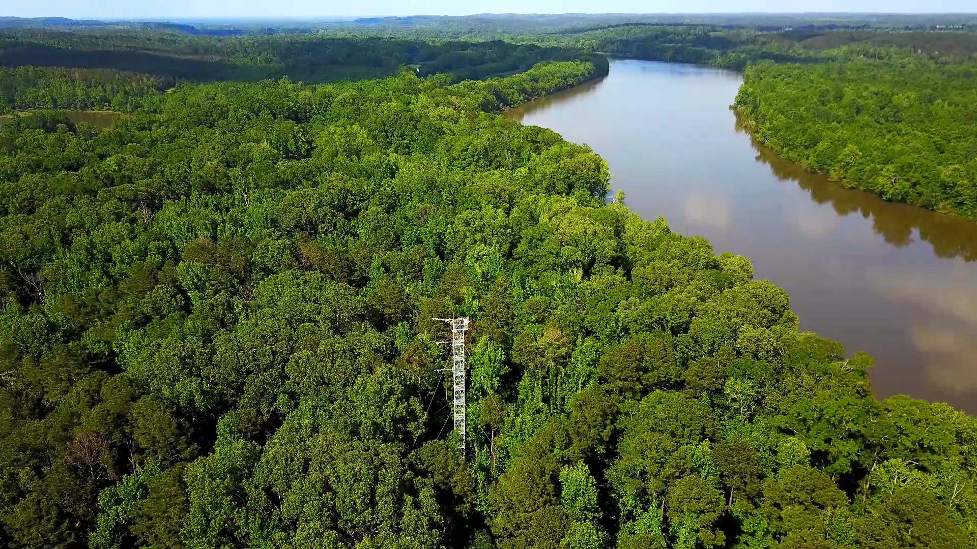
The Lenoir Landing (LENO) relocatable terrestrial site is part of NEON's Ozarks Complex Domain 7. LENO is located across the 4,218-acre Choctaw National Wildlife Refuge and Lenoir Landing Park. The site is located in southwest Alabama approximately 129km (80 mi) north of Mobile. Lenoir Landing Park hosts the Data Tower and tower plots and is managed by the U.S. Army Corp of Engineers. The distributed plots are located 5 km south of the tower shed on the Choctaw National Wildlife Refuge managed by the U.S. Fish and Wildlife Service. The site is characterized by Hardwood bottomland with seasonal flooding and is located along the Tomgigbee River which hosts the Lower Tombigbee river aquatic site. Remote sensing surveys of this field site collect lidar, spectrometer and high-resolution RGB camera data. The flux/meteorological tower at this site is 149 with 6 measurement levels. The tower top extends above the vegetation canopy to allow sensors mounted at the top and along the tower to capture the full profile of atmospheric conditions from the top of the vegetation canopy to the ground. The tower collects physical and chemical properties of atmosphere-related processes, such as humidity, wind, and net ecosystem gas exchange. Precipitation data are collected by a tipping bucket at the top of the tower and a series of throughfalls located in the soil array. This site has five soil plots placed in an array within the airshed of the flux tower. Field ecologists collect the following types of observational data at this site: Terrestrial organisms (birds, ground beetles, mosquitoes, plants, small mammals, soil microbes, ticks), Biogeochemical data, and soil data.