
hydraulic conductivity
Type of resources
Available actions
Topics
Keywords
Contact for the resource
Provided by
Years
Formats
Representation types
-
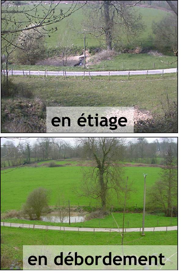
The Chalk Karst observatory groups different karst sites on the Cretaceous Chalk located at the Paris Basin (Norville, Radicatel, Yport, Saint-Martin-Le-Nœud). These karst watersheds range from 10 to 200 km2 and the land use consists of agriculture and grazing under oceanic climate. There are characterized by chalk plateaus covered with clay-with-flints owing to chalk weathering constituting a fairly impervious layer and with quaternary silts. These surficial formations range from 3 to 20 meters depth and are highly susceptible to crusting, compaction, and erosion, particularly during autumn and winter. A numerous swallow holes locally penetrates the chalk through the above-mentioned impervious layer, resulting in a strong connection of the surface with the aquifer inducing infiltration of turbidity releases at spring and well used to drinking water (up to 500 NTU). These Chalk karst sites are one the sites of the French SO-KARST labellised by INSU-CNRS and are a part of the French RBV-Network and ZA Seine.
-

Hydrometeorological observations within 6 embedded catchments (from 0.3 to 3.9 km2). Mediterranean climate with heavy rainfall and flash floods in automn. The geology is mainly granite. The land use is mainly forest. This site is typical of the Cévennes region. More information at http://www.ohmcv.fr
-
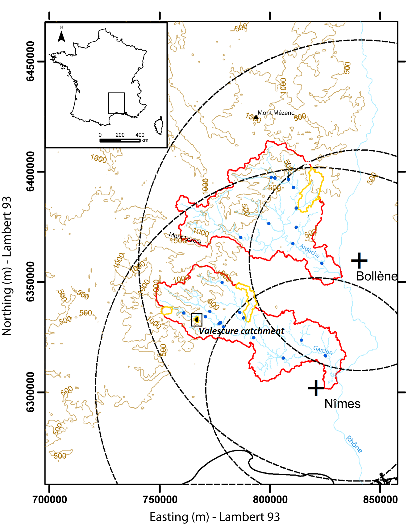
Hydrometeorological observations within 3 embedded catchments (0.9, 2.6 and 14.5 km2). Mediterranean climate with heavy rainfall and flash floods in automn. The geology is mainly shale. The land use is mainly forest. This site is typical of the Cévennes region. More information at http://www.ohmcv.fr
-
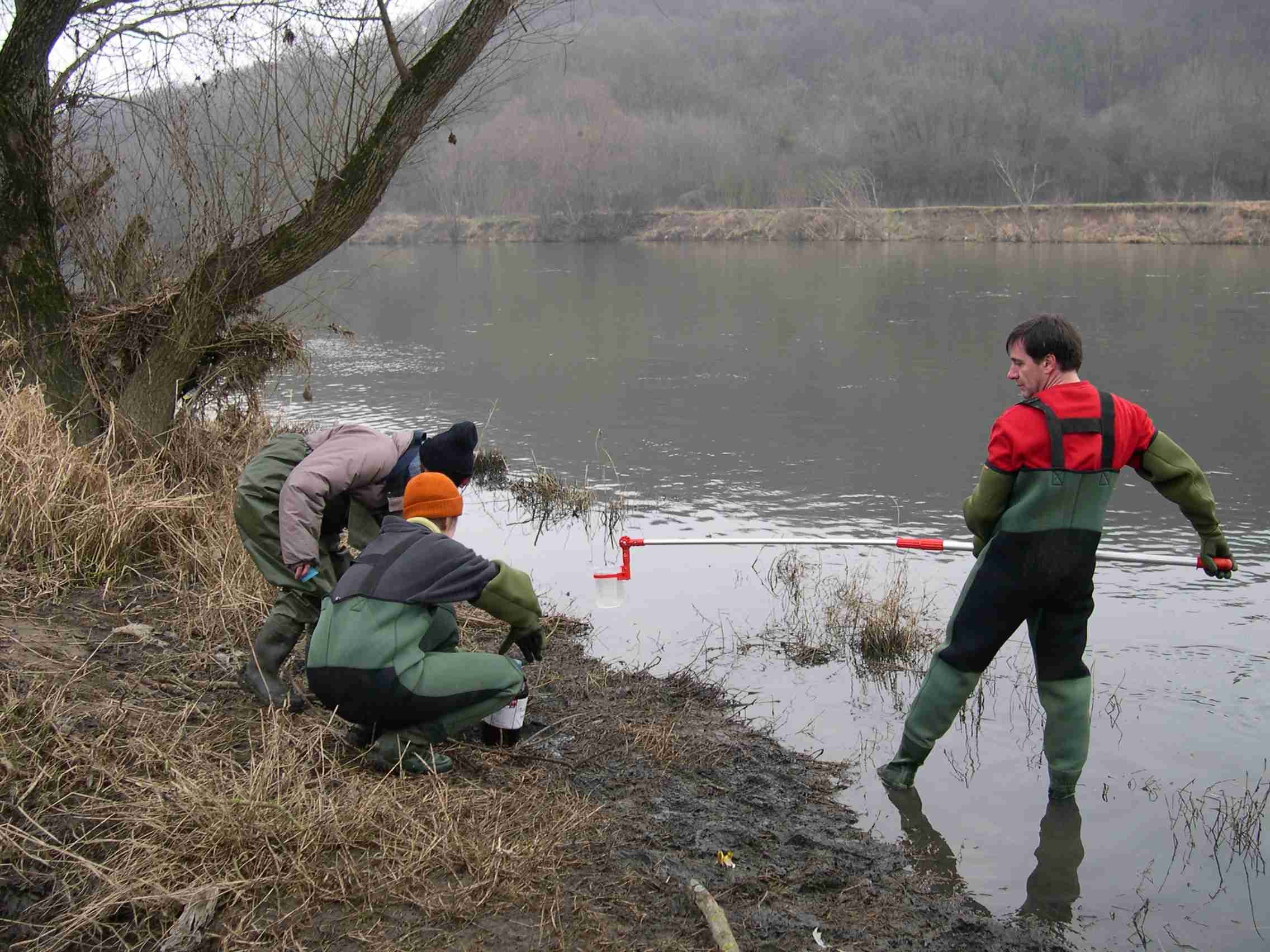
The LTSER Zone Atelier Bassin de la Moselle belongs to LTER-France network and is located in eastern France, Lorraine / Moselle. The ZAM acquires knowledge for better controls the impact of human activities on the quality of the water resources in Lorraine County (France), in the watershed of the Moselle River.
-
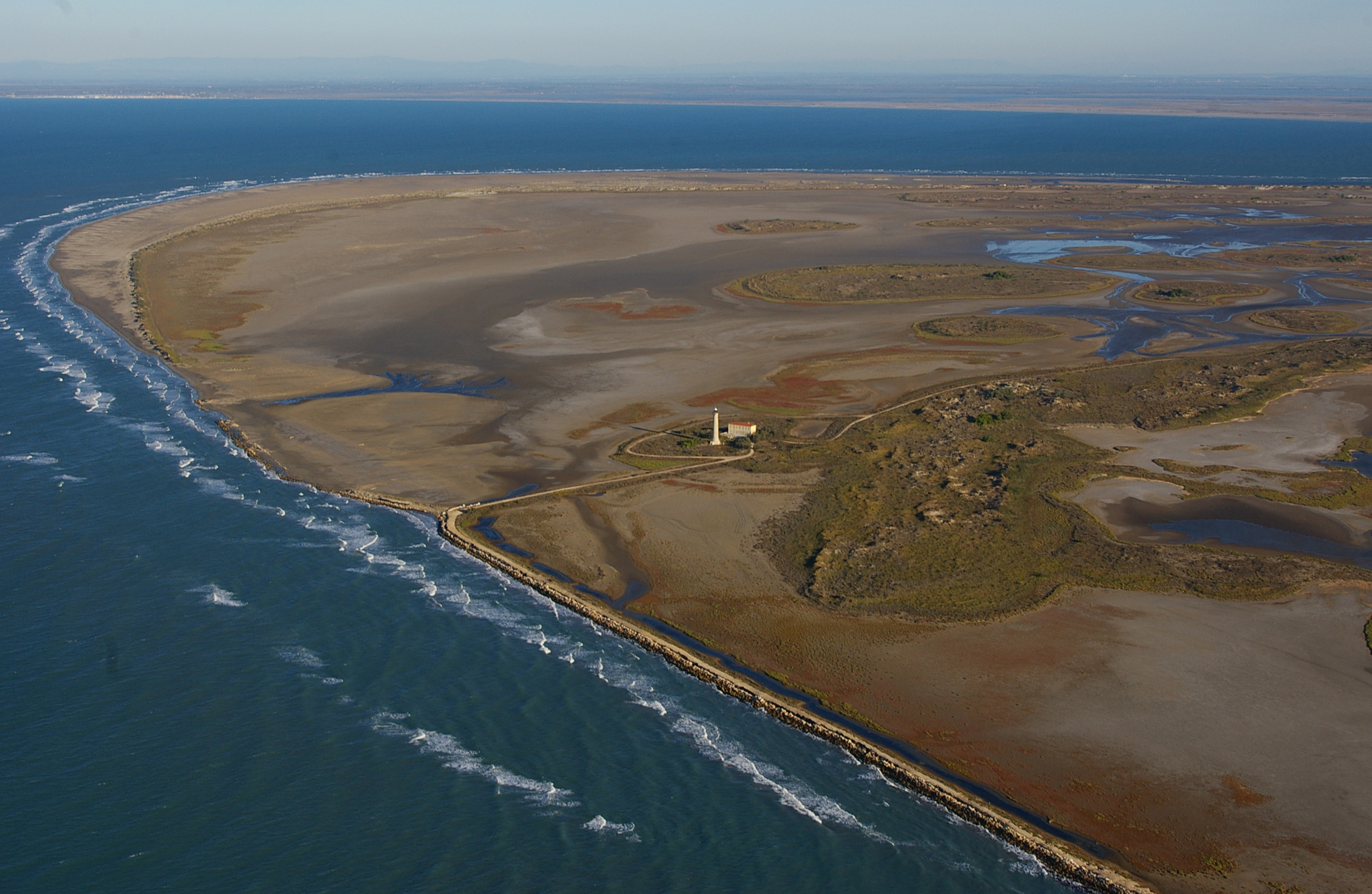
The Camargue Biosphere Reserve covers 193 000 ha, including 50% of natural and semi-natural habitats dominated by lagoons, brackish/freshwater open and reed marshes, halophilous steppes, rangelands and fallow lands. Resilience of these ecosystems to anthropogenic influences is variable and can translate into alpha, beta and gamma biodiversity loss through ecosystem fragmentation and transition (eg, from halophilous steppes to reed marsh following freshwater input), and modification of ecosystem health state with feedbacks on ecosystem services, especially in terms of human uses (waterfowl hunting, bull grazing, reed harvesting, nature conservation). These natural ecosystems are intermingled with agro-systems of which the evolution from family to speculative farming is likely to affect biodiversity. The delta is almost completely polderized, and each year about 400 000 000 m3 of water is pumped from the Rhône to permit rice cultivation (and incidentally water management of marshes and pastures), of which 55% is pumped back to the Rhône, the rest being evacuated (when possible!) to the sea through the Vaccarès lagoon. Sea level rise, climatic variability, modification of agricultural policy (affecting rice farming areas), freshwater availability (increased penetration of the saltwater wedge from the Rhône) and underground salinisation will differently affect these ecosystems of which the dependency upon the hydro-system, primarily developed for rice production, is variable. Considering the high degree of 'artificialisation' of the delta, research and transfer activities at Tour du Valat are mostly targeting human behaviors, since we consider that management actions have currently more impact than evolution of abiotic conditions on ecosystems. Our mail goal is to foster adaptation of users, managers and decision makers to global changes. The Tour du Valat (TdV) is a private research centre located on a 2 600 ha estate (of which 1 800 ha are classified in natural reserve) in the Camargue (Rhône delta), south of France. Created in 1954 and legally recognised as a non-profit-making association, it has set itself the mission to halt and reverse the destruction and degradation of Mediterranean wetlands and their natural resources, and promote their wise use. Pioneer in producing management plans for protected natural areas, its activities are today largely oriented towards multidisciplinary research, co-constructed with or transferred to stakeholders and aimed at preserving the biodiversity, functions and services provided by ecosystems in a context of global changes. Disciplines such as hydrology, remote sensing, plant and animal ecology are combined into three main ecosystem approaches corresponding to modeling, restoration and management. Tour du Valat collaborates with managers, users, research organizations, and administrations. The Biosphere reserve provides a framework for collaborative projects across the entire Delta. Operational decisions are made by the Management Committee, the Technical Committee (made up of partners and stakeholders of the site), and the Scientific Council (involving researchers from Tour du Valat).
-
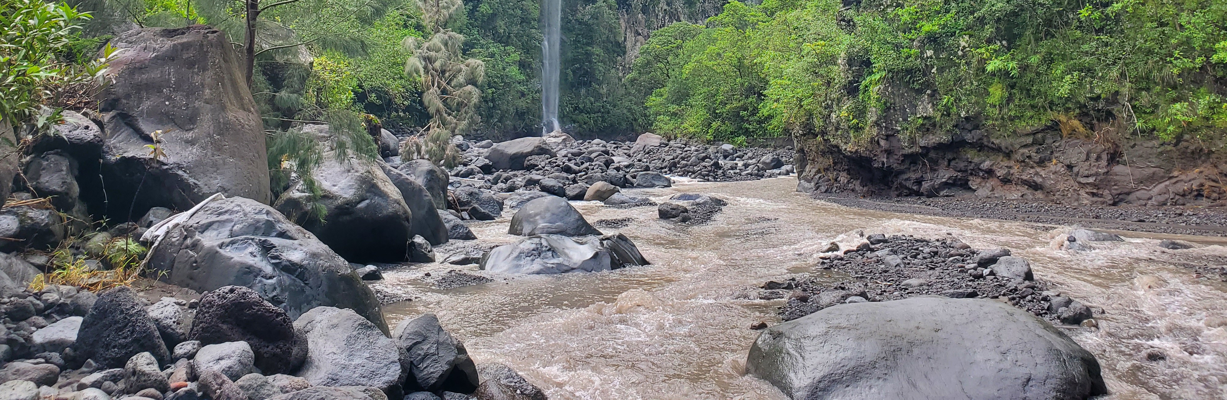
The Bassin de la Rivière des Pluies is located on Réunion Island (French Overseas, Indian Ocean). This volcanic island results from the emission of basaltic products from the Réunion hotspot that initiated 65 Myrs ago with the development of the Deccan traps. Rivière des Pluies drains a watershed of 46 km2 located on the windward side of the dormant Piton des Neiges volcano, from 2276 msl to the sea shore. The Rivière des Pluies catchment is mainly composed of lava flows and breccias aged from 1.4 Ma to 200 ky. The overall watershed is made of a main canyon deeply incised in the volcano flank and a large planeze covered by the deposits of the last explosive eruptions of Piton des Neiges. The combined action of the vegetation and alteration along a strong altimetric gradient produced a wide range of soils typically ranging from 0.5 to 6 meters. Vegetation is dominated by tropical rainforest. The hydrologic regime is torrential: flow rate is characterized by abrupt variations due to tropical rains. Storms and cyclones only occur during the rainy season from december to april.
-
The Jornada Basin Long-Term Ecological Research (LTER) program is part of a national network of long-term ecological research sites funded by the US National Science Foundation (NSF). The Jornada LTER program has been continuously funded since 1982 to develop general principles governing changes between grassland and shrubland ecosystems based on long-term data collected in the Chihuahuan Desert. Research themes at the Jornada LTER focus on vegetation change, climate and land use impacts on ecosystem function, and the role of dryland processes in structuring communities and landscapes. We translate our findings to dryland ecosystems around the world, and forecast the dynamics of future ecosystem states in response to changing climate and land use. The Jornada Basin is located in southern New Mexico, USA, approximately 25 km northeast of the city of Las Cruces (32.6 N -106.7 W, elevation 1315 m). Annual precipitation is 24 cm and maximum temperatures average 13 C in January and 36 C in June. The study site is near the northern extent of the Chihuahuan Desert, which is the largest of the North American warm deserts, in a region has undergone large shifts in the relative dominance of grasslands and shrublands over the past century. We partner closely with the USDA-ARS Jornada Experimental Range (JER) and the NMSU Chihuahuan Desert Rangeland Research Center (CDRRC), allowing us to benefit from a long history of rangeland research, and to contribute to science-based management and sustainability practices.The Jornada Basin LTER project is administered by New Mexico State University.
-
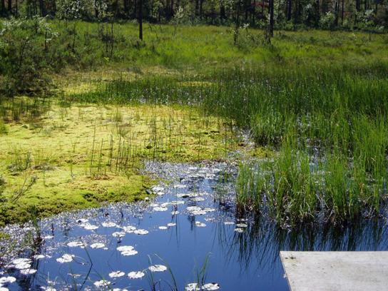
Coniferous forests and mire.
-
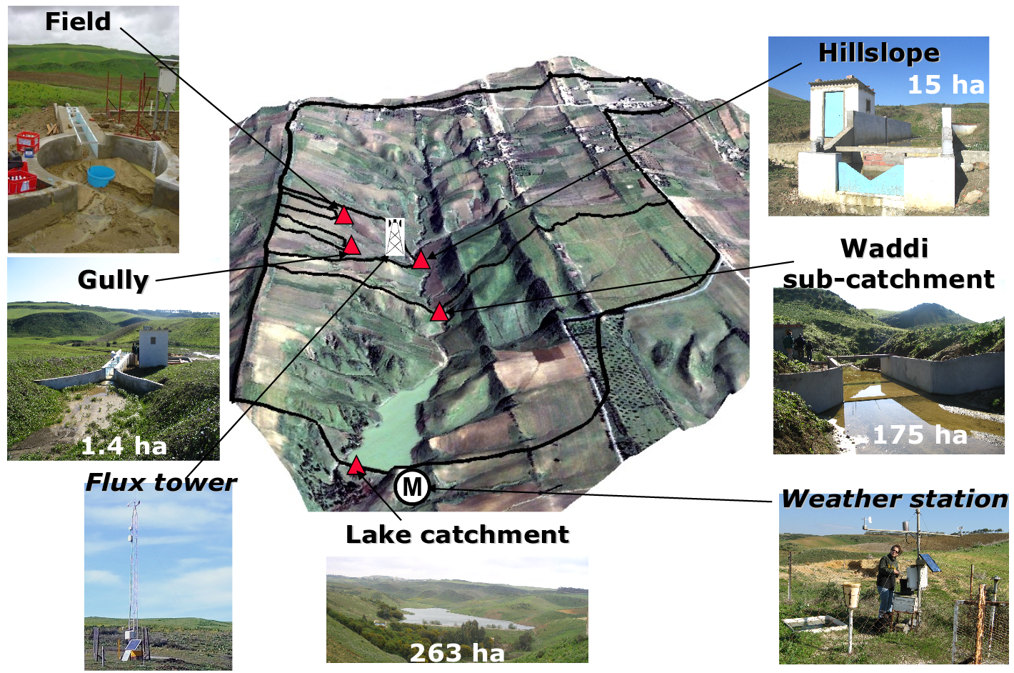
Small agricultural catchment (263 ha) in a Mediterranean environment with 20 years of data: impact of global change (climate and anthropogenic activities as agricultural practices) on water and erosion balance, fluxes and quality. Soils: Calcic Cambisols (63.5%), Regosols (25.5%), Eutric Regosols (9.6%) and Chromic Vertisols (1.4%). Main cultures: cereals and leguminous. Continuous automatic measurements at nested scales from plot to catchment outlet (surface runoff, shallow groundwaters, surface-atmosphere fluxes) and continuous monitoring of anthropogenic activities . More information available on http://www.obs-omere.org. Kamech experimental catchment belongs to the French SOERE-RBV Network.
-
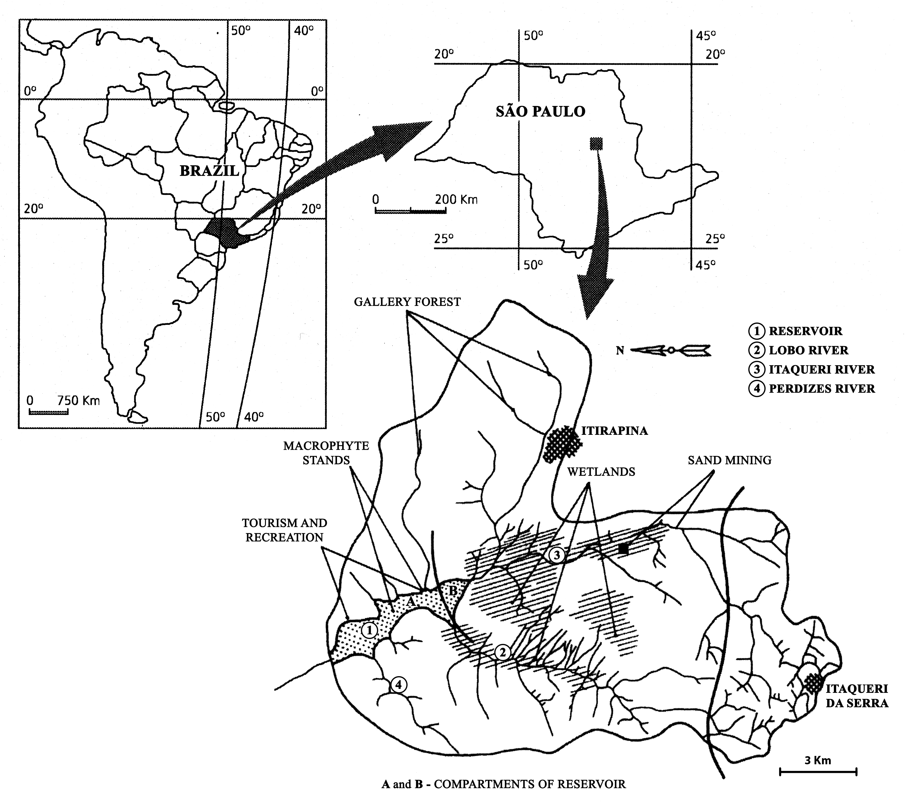
The watershed is located in the center of São Paulo State, Southeast of Brazil. The coordinates are: Lat. 22º 10' 08,5" S; Long. 47º 57' 11,7" W. The drainage density is 0.75km/km2. The maximum altitude is 800m. Basin declivity is 0.00575m/m. The local climate is characterised by alternating dry and wet periods, the wetter period falling in summer and autumn, and the winter and spring seasons being mainly dry. Annual precipitation is around 1500 mm per year. Temperatures are typically between 15 °C and 17 °C during the coldest winter month (July); in the warmest summer month (January), water temperatures between 21 °C to 23 °C are recorded. Potential evapotranspiration is between 500 mm to 1000 mm per year. According to the Koppen classification, the climate is described as ‘warm with a dry period’. The watershed is dominated by holocenic sandy sediments. In the lowland areas, hydromorphic and organic soils predominate. Soils derived from basalt intrusion occur in some areas of the watershed, as red soil hotspots. The natural vegetation is characteristically a savanna type, the Cerrado, typical of the continental regions of Brazil, consisting of bushes and trees adapted to a long (six months) dry season with periodic fires. Given the hydrogeochemical character of the watershed, the ionic strength and the nutrient content of the water of Lobo-Broa Reservoir are correspondingly low.