
irradiance
Type of resources
Available actions
Topics
Keywords
Contact for the resource
Provided by
Years
Formats
Representation types
-
The separation line of the semi-enclosed northern basin from the rest of the Adriatic Sea is conventionally defined at the 100 m isobath, at about 43°20’N, from where the bottom depth moderately decreases up to the northern coast reaching the smallest average depth in the northernmost protrusion of the basin, the Gulf of Trieste (surface area 600 km2, volume 9.5 km3, maximal depth approx. 25 m). The oceanographic properties of Gulf of Trieste are affected by water mass exchange with the northern Adriatic at the open western boundary, by local meteorological conditions that induce a pronounced seasonal cycle of seawater temperature (6 - 28 oC) and by the largest freshwater input, the Soča (Isonzo) River. The latter enters the Gulf on the shallower northern coastline with an average flow of 123 m3 s-1 and represents the major source of land-borne nutrients in this coastal zone, in particular of nitrate, whereas inputs along the south-eastern coast are comparatively small (contributing less than 10% to the freshwater balance in the Gulf). The circulation pattern is variable, however the prevailing ENE wind is the most efficient for the water exchange, especially during winter. These physical features, in addition to freshwater inputs, are ultimately reflected in the distribution of nutrients and in the seasonal and inter-annual variability of plankton communities, primary production but also in events of hypoxia/anoxia and mucous macroaggregates, which have characterised the whole northern Adriatic basin in the recent past. The waters of the Gulf of Trieste have been monitored for several physical-chemical and biological variables since 70s’ but the longest and most continuous data set of biological variables is represented by the phytoplankton time series, which started in 1990 when the national monitoring programme has become operational (set by Slovenian Environmental Agency). From 2007 onwards, the monitoring programme complies with the regulations of the EU Water Framework Directive (2000/60/EC).
-
SITES Lönnstorp research station is situated in the Scanian agricultural landscape between Malmö and Lund and has a focus on the design, sustainable development and assessment of arable cropping systems, in conventional and organic farming. The research station is available for research within ecology, agronomy, environmental science, agroecology and other disciplines. SITES Lönnstorp research station have access to 60 hectares of conventional and 18 hectares of organic farm land, mainly cultivated with annual crops, representative for agricultural practise in southern Sweden. The station is also a part of SITES, Swedish Infrastructure for Ecosystem Science. SITES is a nationally co-ordinated infrastructure for terrestrial and limnological field research. In 2016, SAFE (SITES Agroecological Field Experiment) was established at the research station. SAFE make it possible to compare four different agroecosystems, a conventional reference system, an organic system, a perennial system and an agroecological intensified system.
-
Processing of time series of satellite and airborne images, with different spatial and spectral resolution, in order to derive water quality maps based on physically based algorithms parametrised with specific optical properties of lake Garda. Generation of spatial and temporal information of different water quality parameters of surface water column and coastal zone. Dedicated actives of calibration and validation of satellite images, algorithms and products.
-
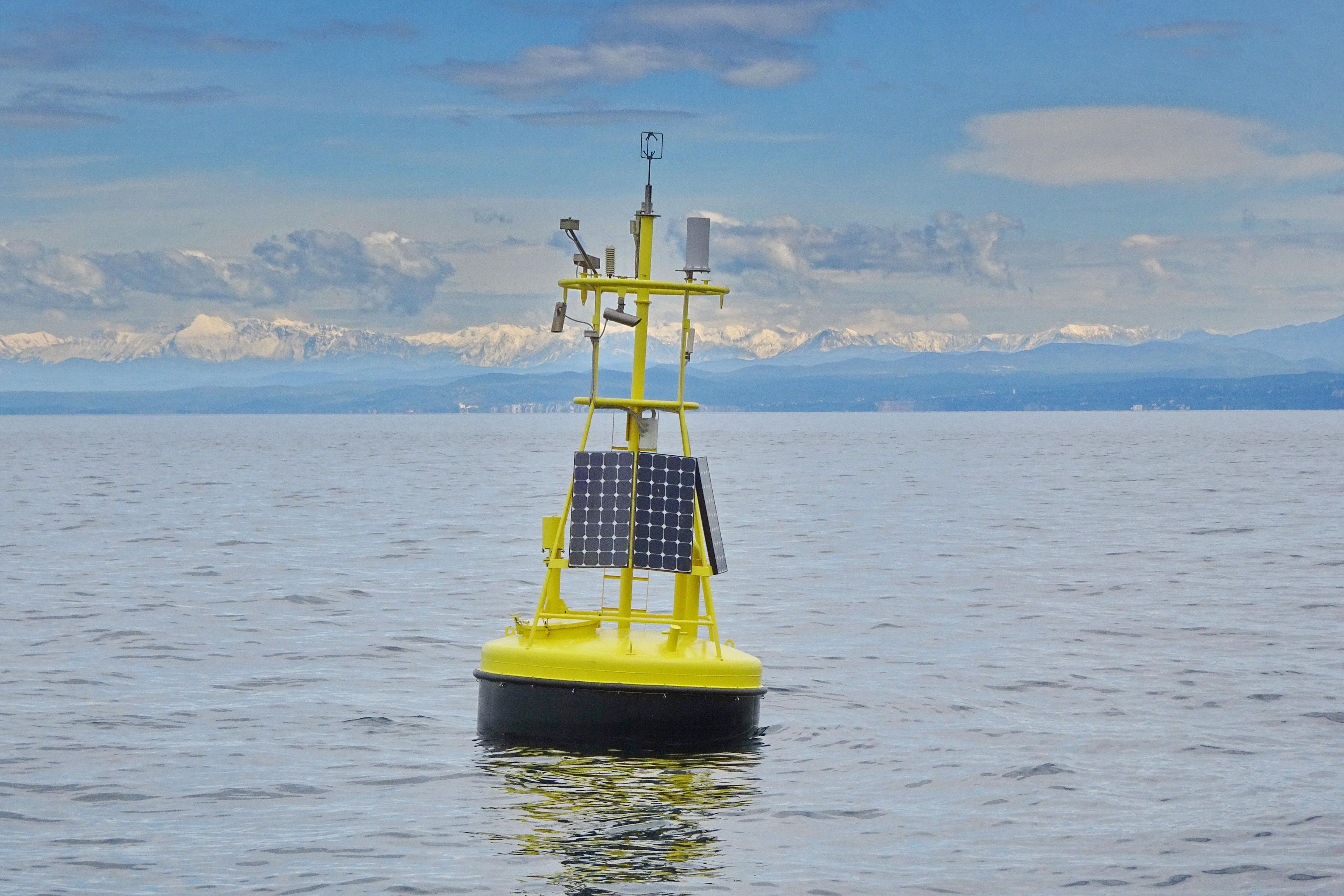
Lake Võrtsjärv is the largest inland water body in Estonia. Is located in Central part of the country (58.286560, 26.049585). Is a large (270 km2) shallow polymictic lake with a maximum depth of 6 m and a mean depth of 2.8 m. According to the classification by Lewis (1983) belongs to continuous rather than discontinuous cold polymictic lakes. Lake Võrtsjärv Buoy was deployed in the summer of 2010 near the deepest point of the lake (N 58.211798, E 26.103163) to gather high resolution data on meteorology and water quality of the lake. YSI EMM 700 bay buoy has been used for float. YSI 6600 V2-4 multisonde (at 1 meter) was fixed at 1 meter depth for underwater measurements. The buoy is equipped with a Vaisala Weather Transmitter WXT520 and a Li-Cor pyranometer (LI-200) for weather parameters. Data collection was controlled with Campbell CR1000 datalogger. System was renewed in 2021. Current underwater measurements are collected with EXO2 multisond and data collection is controlled by Flydog Marine datalogger.
-
Pianosa Island (Long. 10° 04' 44” E and Lat. 42° 35' 07” N) is the fifth, by extension, of the seven islands of the Tuscan Archipelago National Park with a total area of 10.2 km2 and a coastal perimeter of approximately 20 km. The island is almost completely flat, with some small undulations. The highest elevation is 29 m above sea level (a.s.l.), while the average is about 18 m a.s.l. The climate of Pianosa is influenced by its flat morphology that prevents the condensation of moist air, resulting in a mean annual rainfall considerably lower than on the other islands of the Tuscan Archipelago; furthermore, due to the high permeability of the soils, the rain is quickly drained. On the basis of an historical meteorological dataset (1951-2009), mean air temperature is 15.8 °C and mean annual rainfall is 497 mm, ranging between a minimum of 176 mm (1999) and a maximum of 716.2 mm (1984). A clear seasonal precipitation pattern shows a maximum from October to December followed by a decrease with a minimum value in July. The first historical record of Pianosa island dates back to the Roman age, when the Emperor Ottaviano, in the 6-7 A.C., forced the grandson Agrippa Postumo to live on Pianosa island. Following the decadence of the Roman Empire, during the periods of Barbarians’ invasions, the island was abandoned. The name of Pianosa island newly appeared in some documents of the Repubbliche Marinare of Pisa and Genova (XII and XIII century) that reported the remarkable strategic position of the island. The 27th August 1802, Napoleone Bonaparte established that the islands of Elba, Capraia, Pianosa, Palmaiola and Montecristo were united to the territory of the French Republic. Bonaparte visited Pianosa twice and found it the most interesting of the other islands, appreciating its richness of vegetation and animals. In 1858 Pianosa became an Agriculture Penal Colony, where the prisoners were forced to work in the fields. During the ’70s the jail of Pianosa became a maximum security penitentiary. Only in the ’80s, representatives of the Government and members of the civil society started to propose to close the prison and to return Pianosa to the competent civil authority. In view of this, the number of the prisoners was drastically reduced and, consequently, several agriculture activities progressively stopped. In the 1997 the territory of Pianosa was formally included in the National Park of the Tuscan Archipelago and since than it is a site for natural conservation. In 1998 the penitentiary was completely dismissed
-
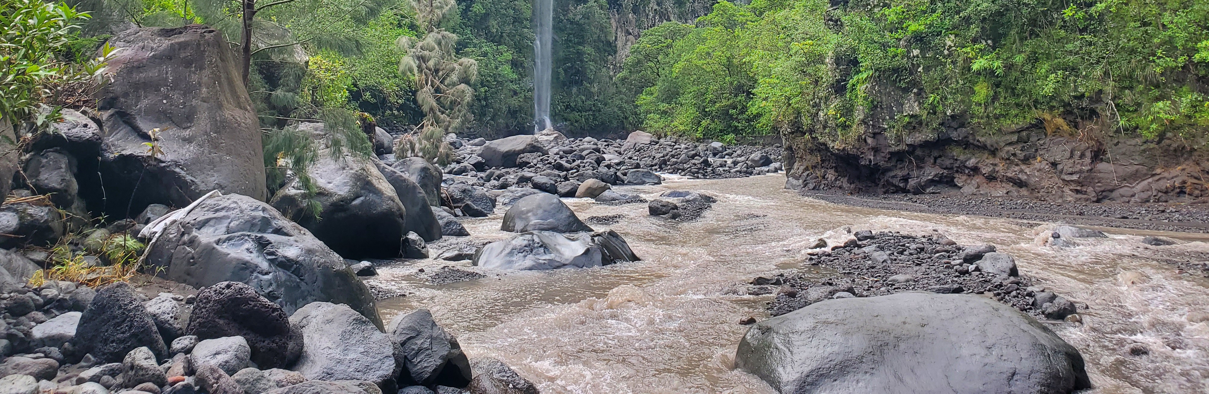
The Bassin de la Rivière des Pluies is located on Réunion Island (French Overseas, Indian Ocean). This volcanic island results from the emission of basaltic products from the Réunion hotspot that initiated 65 Myrs ago with the development of the Deccan traps. Rivière des Pluies drains a watershed of 46 km2 located on the windward side of the dormant Piton des Neiges volcano, from 2276 msl to the sea shore. The Rivière des Pluies catchment is mainly composed of lava flows and breccias aged from 1.4 Ma to 200 ky. The overall watershed is made of a main canyon deeply incised in the volcano flank and a large planeze covered by the deposits of the last explosive eruptions of Piton des Neiges. The combined action of the vegetation and alteration along a strong altimetric gradient produced a wide range of soils typically ranging from 0.5 to 6 meters. Vegetation is dominated by tropical rainforest. The hydrologic regime is torrential: flow rate is characterized by abrupt variations due to tropical rains. Storms and cyclones only occur during the rainy season from december to april.
-
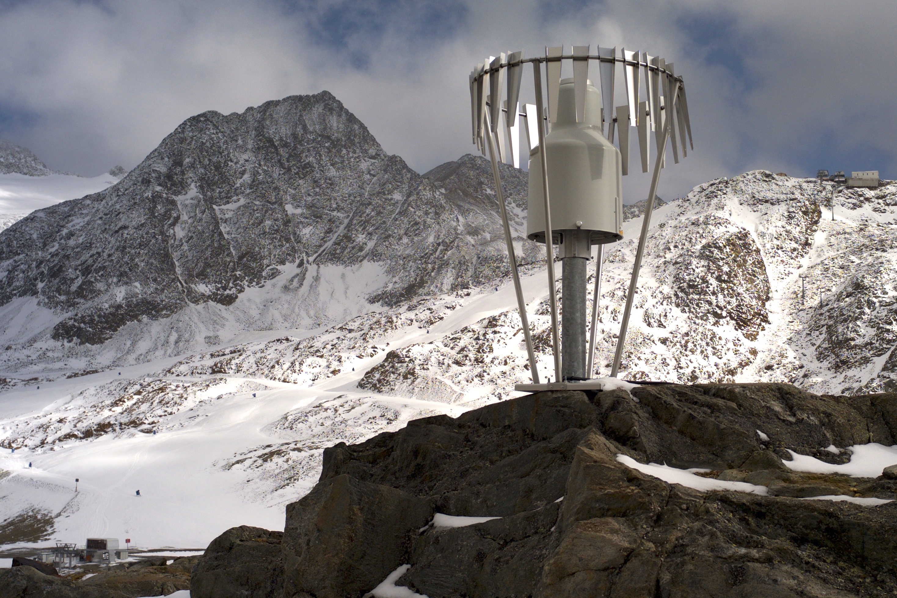
In the Rofental (Ötztal Alps) a consortium of the three institutions, and open to research partners worldwide, concentrates on studying and monitoring cryospheric, atmospheric and hydrological processes and changes with particular attention to the complex topography and climate settings of the Alpine terrain. First documents from glaciers in the Rofental, Ötztal Alps, date back as far as 1601 and regular observations and systematic studies had begun more than 150 years ago. First geodetic maps where generated in the late 19th century, first rain gauges were mounted in 1929 and glacier mass balance time series of Hintereis-, Vernagt- and Kesselwandferner are among the longest uninterrupted world-wide, building a basis for regional hydrological studies, for glacier-climate and ice dynamic research, and for estimating the world wide glacier’s contribution to sea level rise. By 2014, networks of stakes and pits for mass balance monitoring are maintained at Hochjoch-, Hintereis-, Kesselwand- and Vernagtferner by the consortium members. Runoff gauges at Vernagtferner and in Vent (operated by the Hydrological Office of Tyrol) and a network of rain gauges in the Rofental basin are the basis for high mountain hydrological studies. A varying number of automatic weather stations on and in the surroundings of the glaciers are operated by the Rofental consortium. The glaciers in the Rofental are frequently used as a test site for process studies, model development and evaluations and for new remote sensing or ground based methods in glaciological research. A series of airborne LIDAR derived high resolution DTMs of Hintereisferner and its surroundings are available since 2001. They are subject of ongoing evaluations and method comparison studies as well as for monitoring and studying periglacial morphodynamics. The generated data are available from the consortium partners, glaciological key results are annually reported to the World Glacier Monitoring Service (WGMS). A research station on Hintereisferner (with observer status in the Horizon 2020 INTERACT network) and one at Vernagtbach serve as logistic bases for fieldwork. In recent studies, socio-ecological research aspects – e.g. in relation with the use of water for energy production and tourism – comprise the natural scientific investigations.
-
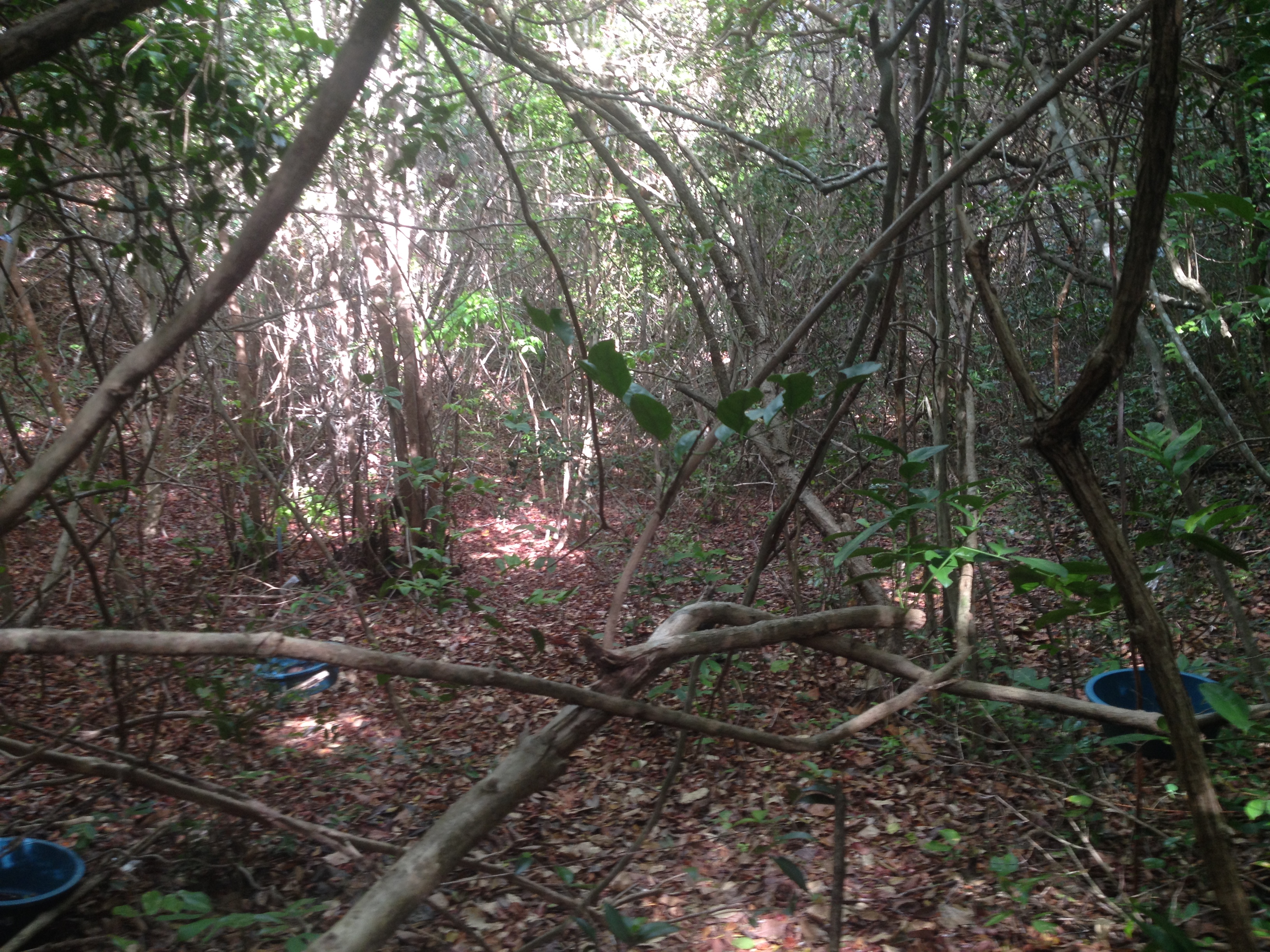
Restinga semideciduous broadleaf forest with trees varying between 4 and 10 meters tall growing on nutrient-poor white sand soils distributed parallel to the Atlantic coastline. Mean annual temperature is 26oC and mean annual precipitation is 1746mm, concentrated between March and August. Dry season length (months < 100 mm) experience considerable interannual variation (3-9 months) and averages 6.2 months.
-
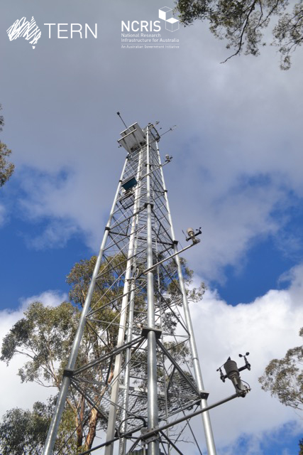
The Victorian Dry Eucalypt SuperSite is a member of the Australian SuperSite Network (SuperSites, http://www.supersites.net.au/), a facility within the Australian Terrestrial Ecosystem Network (TERN, http://www.tern.org.au/) and has two nodes (Whroo and Wombat). The Victorian Dry Eucalypt SuperSite - Whroo site near Shepparton was established in 2011. The vegetation is dominated by two main Eucalypt species: Eucalyptus microcarpa (Grey Box) and Eucalyptus leucoxylon (Yellow Gum). Smaller numbers of Eucalyptus sideroxylon (Ironbark) and Acacia pycnantha (Golden Wattle) are also found on site. The surrounding area includes the Whroo Historical area, and Rushworth State containing remnant native vegetation. Key research objectives include: • What are the elements of structure, composition, functions and processes of the dry eucalypt forests of South Eastern Australia required for the sustainable management of these ecosystems? • What is the carbon sink/source strength of a dry sclerophyll forest and what is their contribution to Australia’s National Carbon Inventory? • What is the magnitude of emission and/or uptake of non-CO2 greenhouse gases, such as nitrous oxide and methane of dry eucalypt forest? • How will climate variability, drought or fire influence the ecosystem processes of dry eucalypt forest? . The site is on the lands of the Ngurai-illam-wurrung Aboriginal people.
-
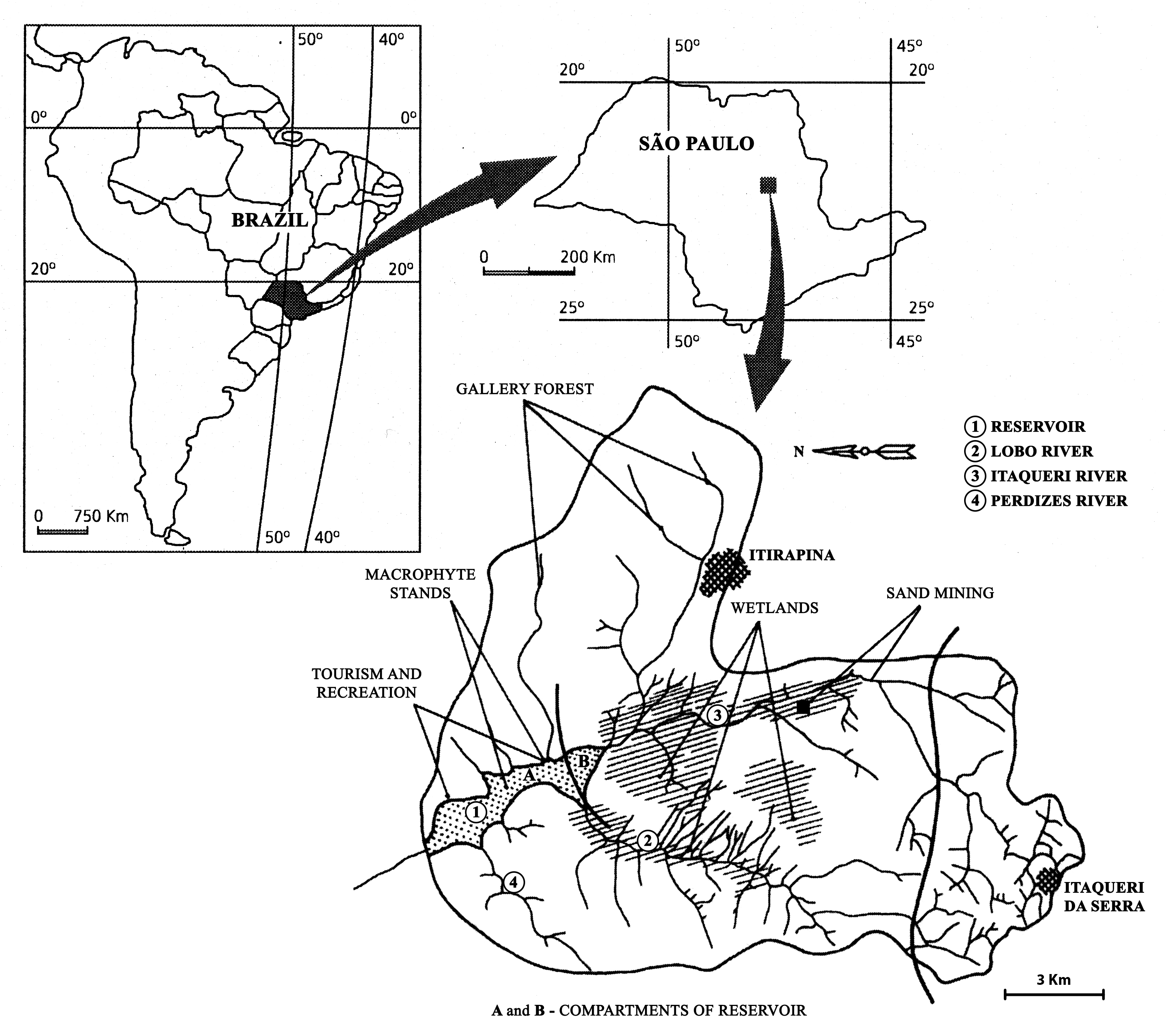
The watershed is located in the center of São Paulo State, Southeast of Brazil. The coordinates are: Lat. 22º 10' 08,5" S; Long. 47º 57' 11,7" W. The drainage density is 0.75km/km2. The maximum altitude is 800m. Basin declivity is 0.00575m/m. The local climate is characterised by alternating dry and wet periods, the wetter period falling in summer and autumn, and the winter and spring seasons being mainly dry. Annual precipitation is around 1500 mm per year. Temperatures are typically between 15 °C and 17 °C during the coldest winter month (July); in the warmest summer month (January), water temperatures between 21 °C to 23 °C are recorded. Potential evapotranspiration is between 500 mm to 1000 mm per year. According to the Koppen classification, the climate is described as ‘warm with a dry period’. The watershed is dominated by holocenic sandy sediments. In the lowland areas, hydromorphic and organic soils predominate. Soils derived from basalt intrusion occur in some areas of the watershed, as red soil hotspots. The natural vegetation is characteristically a savanna type, the Cerrado, typical of the continental regions of Brazil, consisting of bushes and trees adapted to a long (six months) dry season with periodic fires. Given the hydrogeochemical character of the watershed, the ionic strength and the nutrient content of the water of Lobo-Broa Reservoir are correspondingly low.