
land use
Type of resources
Available actions
Topics
Keywords
Contact for the resource
Provided by
Years
Formats
Representation types
-
Land uses and vegetation cover, based on photo interpretation of aerial photographs from 2007.
-
Land uses and vegetation cover, based on photo interpretation of aerial photographs from 1956.
-
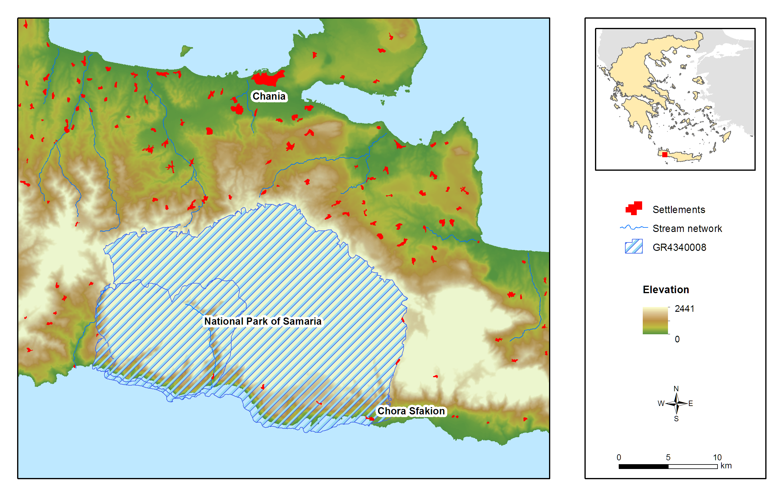
Samaria (White Mountains) National Park is located on the West part of island of Crete and was declared as a National Park via a Royal Decree in 1962. It is a muli-designated area and specifically a National Park, Landscape of Outstanding Beauty, Natura 2000 site coded GR 4340008 and GR4340014 and Biosphere Reserve in the framework of the “Man and Biosphere” Programme of UNESCO. It has been awarded with the European Diploma of Protected Areas of the Council of Europe. Also a hotspot for biodiversity and a place with a strong and important anthropogenic environment (history, special songs, traditions, etc.). It contains one of the largest gorges in the Balkans, Samaria Gorge, with a total length of 13 km while nine main gorges are located within the area of the White Mountains. These specific landscape configuration schemes sustain unique abiotic and biotic environmental characteristics, most of them unknown, because of the site’s wilderness and difficultness for direct scientific filed work. The specificity of the area can be easily identified in numbers: 58.454 ha, altitude ranging from 0-2.454m, more than 50 summits higher than 2000 meters a.s.l., 14 different types of habitats, approximately 40% of the entire extent of the county of Chania. Mean Annual Rainfall is between 600mm to 2000mm depending on the elevation. The entire area comprises one of the two main environmental lungs of Crete and a configuration leading to the current meteorological and hydrological conditions set in the western part of the island. President of the National Park is Dr. Petros Lymperakis, researcher from the Natural History Museum of Crete (lyberis@nhmc.uoc.gr). The National Park is characterized by a rich biodiversity, a high degree of endemism in fauna and flora, distinctive geological configurations and specific landscape features. Distinctive species of fauna found in the area are: the Cretan wild goat (Capra aegagrus cretica), the largest mammal of the island, the Cretan wildcat (Felis sylvestris cretensis) and a species of mouse (Acomys minous) which is considered to be rare. The rich avifauna of the area includes 69 species, with Gypaetus barbatus among others. The area houses 172 endemic species and subspecies, while 97 of them are endemic to Crete and 24 are specifically endemic (steno-endemic) to smaller areas. Some of the most distinctive species are: Cephalanthera cucullata, Nepeta sphaciotica, Bupleurum kakiskalae and Zelkova abelicea. The past 2 years a complete survey has begun in order to identify the Park’s central environmental characteristics. Nowadays, the monitoring system is comprised by: 1) Monitoring and surveillance of 15 terrestrial habitats and 34 species of flora. 2) Monitoring and surveillance of 256 species of avifauna. 3) Monitoring and surveillance of all possible species of fauna, including coastal and marine species. 4) Monitoring and surveillance of two marine habitats. 5) Recording of meteorological and hydrological conditions via four (4) meteo-stations located in the vicinity of the National Park and transmittance of data through the internet. The basic threats and pressures characterizing the site can be cumulated in: Α) Landscape fragmentation Β) Desertification induced by overgrazing and uncontrolled fires C) Modifications in water and groundwater regime induced by large scale infrastructures D) Poaching and uncontrolled abstraction of endemic species of flora E) Massive touristic flow and F) Relative medium and large-scale touristic infrastructures.
-
Lesvos is a geological mosaic assembling from limestones a.o. metamorphic rocks and soils to volcanic and serpentine ones. It is characterized by three climatic profiles (semi-arid, arid–sub-humid, and a transitional one). Considering its size (1,634 km2), the island is rich in habitat types extended from thermo-Mediterranean (phrygana, scrub, pine forests), meso-Mediterranean (evergreen to semi-evergreen oak forests), through to supra-Mediterranean (deciduous oak and chestnut forests), even up to montane-Mediterranean zone (black pine forests). Furthermore, the island encompasses interesting man-made systems, such as agro-ecosystems (olive groves, cultivated & abandoned fields), terraced landscapes, graze lands, salt-works, not to forget its numerous wetlands.
-
Aerial photographs and LiDAR data of the LTER Zöbelboden catchment
-
LTSER Trnava is located in the south-west Slovakia, in territory of one city (Trnava) and 44 rural municipalities with total area of 741.33 km2. Arable land dominate (65.13 %), followed by forests (17,78%), built-up area 7.84%, grassland (2.15%), gardens (1.83%), water bodies (1,38%), vineyards (0,81%), orchards (0.2%), and other plots (2.9%). The main part of the LTSER (central and southern parts) is located in the Danubian Lowland. Because of the best, most fertile soils and favourable climatic condition, it is intensively used for agriculture, especially as arable land. In this part of LTSER is located the largest settlement – Trnava. It represents the administrative centre of the county and region with highest population, trade and industry. Hilly northwest part of the LTSER, located in the Little Carpathians Mts. belongs to the Malé Karpaty Protected Landscape Area. This is the only large protected area having vineyard character in Slovakia; vineyards forms transition belt between lowland arable land and forested hills/mountains. Several types of deciduous forests are developed – oak-hornbeam and beech forests are most common, in steeper sites are developed ravine forest dominated by ash and maple. The LTSER represents intensively used industrial and agricultural area with specific environmental problems (strong degree of contamination of environment, the degradation processes of agricultural land, etc.) and low degree of ecological stability. Use of the most productive soils for construction of industrial parks represents a significant environmental issue.
-
The LTER site is a COMPLEX site, with observation sites focusing (a) on the three glaciers in the Kaunertal Valley, (b) 10 ecological and erosion sites along a succession gradient in the pro glacial, and (c) one climate station. The station (a) is run by Andrea Fischer (AAS), stations (b) and (c) within the PHUSICOS project coordinated by Sabine Kraushaar (University of Vienna). In the proglacial area of the Gepatschferner glacier ten mechanical erosion sites with each three plots (each 2x3m, see picture) are installed monitoring biotic and abiotic interrelations in 5 different succession classes. Small scale erosion processes such as splash, rill and interill erosion processes are quantified as a function of the present species composition. A climate station on 2350m run by solar power complement the set up.
-
The observatory consists of 16 headstreams (15 in the Moselle River watershed, 1 in the Rhône River watershed), draining forest (mixed coniferous, beech) watersheds on sandstone and granites at very different altitudes.
-
Lake Engure drainage area (644 sq.km) includes the Lake which is a remnant of Litorina sea formed about 4000 years ago. Part of the territory is the Lake Engure Nature Park, the Ramsar site including unique inland and marine wetlands. Most of the drainage area is covered by pine forests, but there are also large areas of marshlands, meadows, deciduous forests, dunes and agricultural lands. Avifauna lists 186 species, vascular plants – 844 species. 44 species of birds, 5 fish species and 3 plant species are protected at European level, 23 habitats are in EU Habitat Directive. The ecosystems of the area have been changed by different human activities historically well documented. The most important activities in ancient times included regulation of water level, hay making, pasturing, hunting, and fishery. The traditional settlement type was the former fishermen's village, which is characterized by its linear structure along the seashore and farmsteads inland. During the past decade, such settlements have been subject to a wave of summer cottage, second home and guest house construction. The agriculture and main industry (fishing and fish processing) has sharply declined. Nowadays, the highest number of employees is in the service sector (wholesale, catering, tourism and leisure industries). It sets a new kind of pressure to the ecosystems of the region.
-

The sites Friedeburg, Greifenhagen, Harsleben, Schafstädt, Siptenfelde and Wanzleben are part of the TERENO Harz / Central German Lowland Observatory in Saxony-Anhalt run by the Helmholtz Centre for Environmental Research UFZ. These sites have a focus on biodiversity monitoring in the “normal landscape” which is characterized by agricultural use (about 60 % coverage of Saxony-Anhalt). Each site is a 4x4 km landscape of mainly arable land and semi-natural habitats like e.g. hedges and forests. The site Schafstädt is part of the "Querfurter Platte" ranking about the richest soils in Germany. It is characterized by a quite flat topography and a mean elevation of 177 m asl. The average size of crop fields is highest compared to the other sites and the total area covered by crop fields is still 97 % and all semi-natural habitats summing up to 2 %.