
maximum temperature
Type of resources
Available actions
Topics
Keywords
Contact for the resource
Provided by
Years
Formats
Representation types
-
The dataset contains potential spatial distribution maps for the European badger (Meles meles) under the current conditions and onto IPCC scenarios. In addition, maps showing the significative differences between forecasting are also provided.
-
Trends in the seasonal and annual values of precipitation, temperature and combined daily indices have been assessed from 1970 to 2007. The dataset consists of precipitation and temperature for 113 grid points in southeast Iberian Peninsula, with a resolution of 0.2º both daily and monthly basis. It was developed from main AEMET stations in Spain using kriging algortihms (Herrera, S., Gutiérrez, J. M., Ancell, R., Pons, M. R., Frías, M. D., & Fernández, J. (2012). Development and analysis of a 50‐year high‐resolution daily gridded precipitation dataset over Spain (Spain02). International Journal of Climatology, 32(1), 74-85). This work allowed discovering distinct local/regional signals in SE Spain. Some of these climatic changes seem partially linked to important land use and land cover changes undergone in the region and should have had significant impacts on ecosystems functioning.
-
Climate and deposition data from the Svartberget research station
-
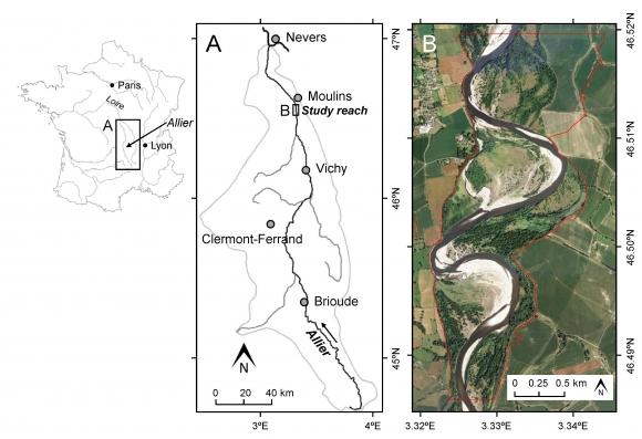
This study site is in the south of the city of Moulins, including the National Nature Reserve of the Val d'Allier which protects 1,450 hectares over approximately 28 km along the lower course of the Allier River. The Allier river is considered as the last wild river of Europe because of its strong fluvial dynamics and remaining free meandering river segments. The studied sector within the nature reserve is still very mobile, with a strong lateral dynamic, where the width of the divagation can be of the order of one kilometer. At this scale, it is unique in Europe.
-
High resolution hydrology recording mainly by PLSC_Sensors (measuring water level, temperature-depending on water level it is the ground air temperature or water temperature- and conductivity) but also by Hydrolab-Multiparameter Sensors (measuring temperature, oxygen, pH, conductivity, turbidity) for monitoring the soda pans in the vicinity of soda Lake Neusiedl. The on-line measurement of these wetland sensors in the “Seewinkel”-district are measuring at high time resolution of every three minutes. The locations of these sensors are in the soda pans, which mostly dry out at least once a year, and are as follows (in alphabetical order): Hydrolab-Waterquality_Multiparameter-Sensor - Fuchslochlacke: N47°47.376’ & E016°51.149’ PLSC-Sensor - Fuchslochlacke: N47°47.376’ & E016°51.149’ PLSC-Sensor - Graurinderkoppel: N47°43.400’ & E016°48.148’ PLSC-Sensor - Meierhof-Lacke (Apetloner Hof): N47°43.296’ & E016°49.359’ PLSC-Sensor - Unterer Stinker: N47°48.161’ & E016°47.098’
-
High resolution recording of water quality and water hydrology by two types of sensors monitoring the open lake and reed belt sites at Lake Neusiedl: Hydrolab-Multiparameter sensors measuring temperature, oxygen, pH, conductivity, turbidity and chlorophyll-a; PLSC_sensors for water level, water temperature and water conductivity. The on-line recording of these sensors measures at high time resolution of every three minutes. The two types of sensors are located as follows (in alphabetical order): Hydrolab-Multiparameter_Sensor - Neusiedlersee-Steg: N47°46.208’ & E016°45.129’ Hydrolab-Multiparameter_Sensor - Neusiedlersee-Ruster Poschn: N47°46.631’ & E016°45.187’ PLSC_Sensor - Neusiedlersee-Steg: N47°46.208’ & E016°45.129’ PLSC_Sensor - Bootshafen Biologische Station: N47°46.128’ & E016°45.976’
-
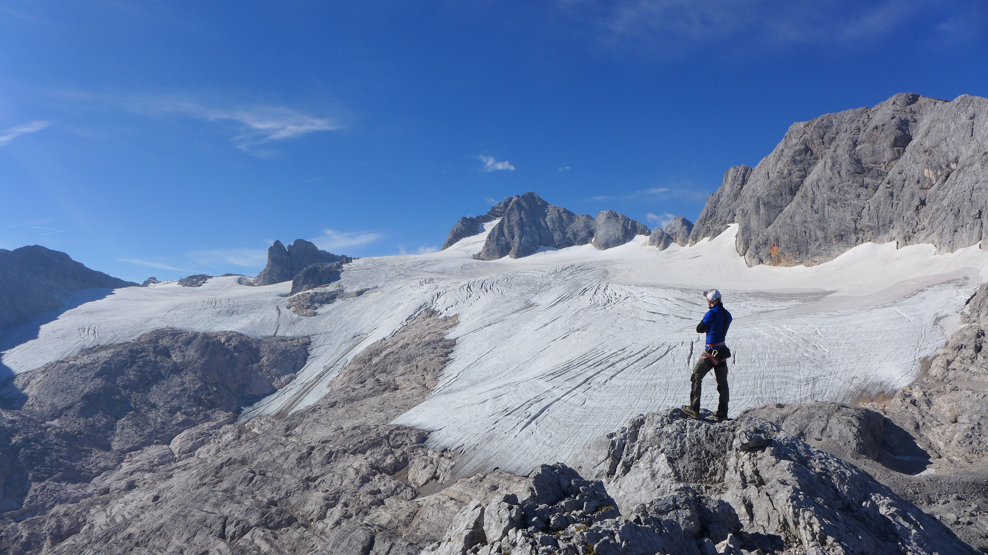
The Hallstätter Glacier is the largest glacier in the northern Limestone Alps. The Hallstätter Glacier is oriented to the northeast and is bordered by Rock walls. The Large plateau above 2550 m.a.s.l. is connected by three short tongues. The largest altitude zone in terms of area is between 2550 m and 2600m. The highest point of the glacier is at 2905 m, the lowest point is on 2240 m. With an area of 2.623 km² (glacier boundary 2020), the glacier lost half of its extent compared to the glacier peak in 1856. In the past 10years, the area has increased by around 13 %.
-
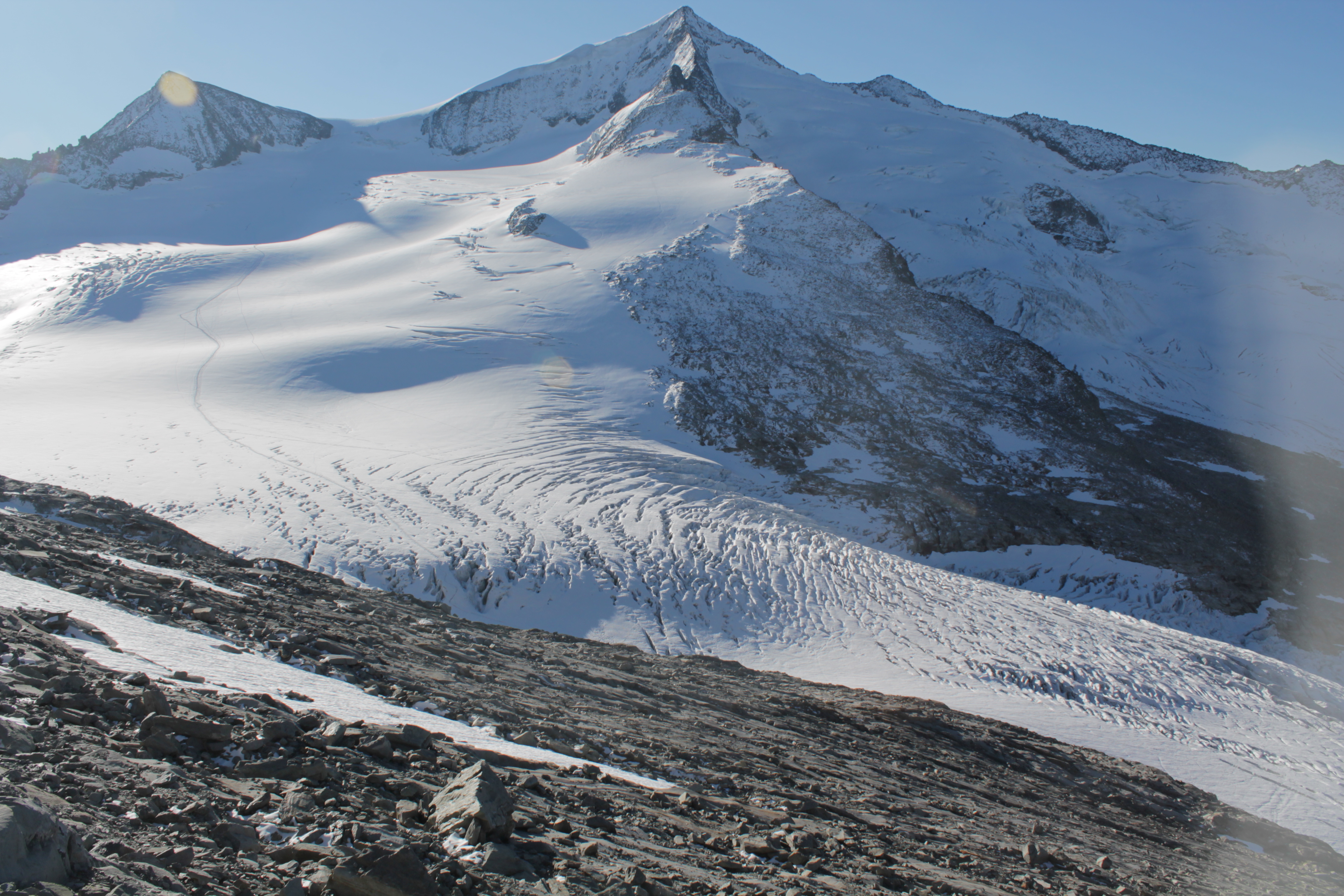
The Venedigerkees in the Hohe Tauern National Park is the easternmost tributary glacier to the former tongue of Obersulzbachkees. As a result of the strong retreat of Obersulzbachkees, the glacier disintegrated into several tributary glaciers, with a large lake remaining at the location of a famous serac zone, the 'Türkische Zeltstadt'. Mass balance of the Venedigerkees is measured since 2011/12 with the direct or glaciological method. Furthermore, an automatic weather station was built between Venedigerkees and Keeskogel in 2018.
-
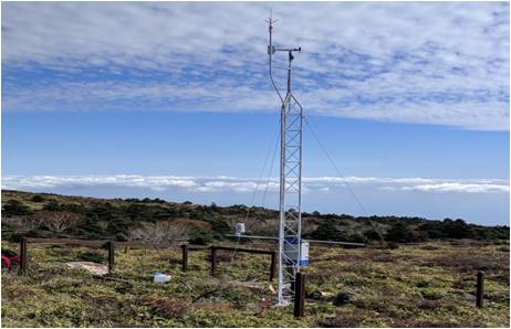
The meteorological sensors are located on the roof of the main building of the Biological Station (N 47,7691; E 16,7662; Position (elevation): 122 msl) in the close vicinity of Lake Neusiedl. The parameters that are on-line recoded every 15 minutes are as follows: Air humidity (%RH), Global radiation (W/m²), Air temperature (°C), Wind speed ([Average] (km/h), Wind direction (°), Rain yearly (mm), Precipitation (mm); time resolution: 15 minutes. There are also two traditional weather stations at the station and on the jetty, which are maintained by the Hydrolographic Service Burgenland and enable parameters such as temperature, humidity, precipitation and water level to be recorded. In addition to the Adcon weather station on the roof of the station, there are currently 3 other stations in operation in Seewinkel. These positions are: • Unterer Stinkersee (N 47,8018; E 16,7842) • Neudegg (N 47,7029; E 16,8098) • Östliche Fuchslochlacke (N 47,7907; E 16,8624)
-
Mt Halla San is in Jeju Island, the only volcanic subtropical island, in South Korea. Every year the island is hit by several typhoons. It has shaped unique environmental characteristics and biodiversity. In addition the mountain is one of the most popular vacation sites with growing ecological concern.