
mean annual temperature
Type of resources
Available actions
Topics
Keywords
Contact for the resource
Provided by
Years
Formats
Representation types
-
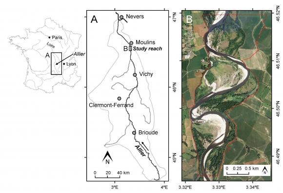
This study site is in the south of the city of Moulins, including the National Nature Reserve of the Val d'Allier which protects 1,450 hectares over approximately 28 km along the lower course of the Allier River. The Allier river is considered as the last wild river of Europe because of its strong fluvial dynamics and remaining free meandering river segments. The studied sector within the nature reserve is still very mobile, with a strong lateral dynamic, where the width of the divagation can be of the order of one kilometer. At this scale, it is unique in Europe.
-
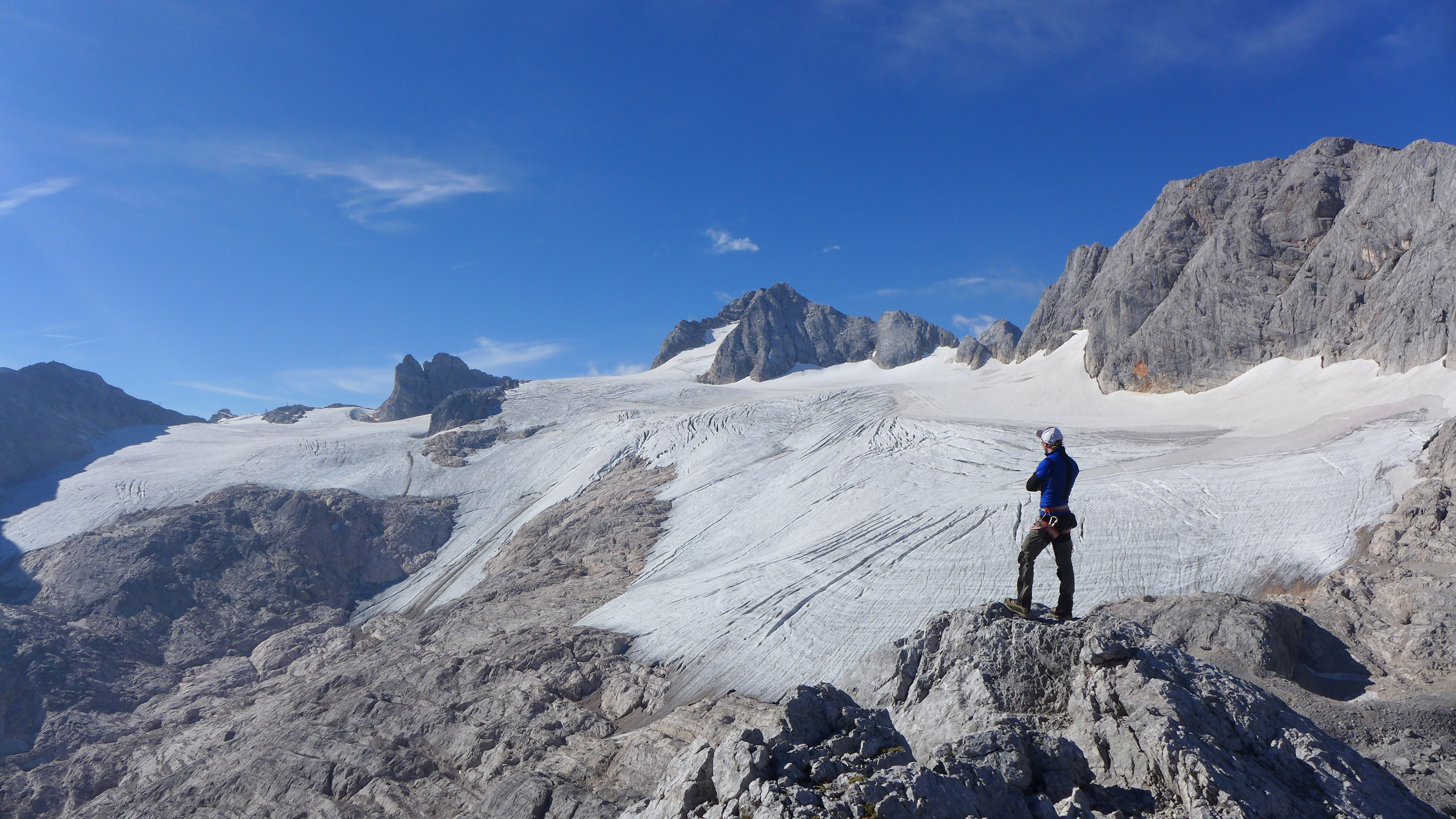
The Hallstätter Glacier is the largest glacier in the northern Limestone Alps. The Hallstätter Glacier is oriented to the northeast and is bordered by Rock walls. The Large plateau above 2550 m.a.s.l. is connected by three short tongues. The largest altitude zone in terms of area is between 2550 m and 2600m. The highest point of the glacier is at 2905 m, the lowest point is on 2240 m. With an area of 2.623 km² (glacier boundary 2020), the glacier lost half of its extent compared to the glacier peak in 1856. In the past 10years, the area has increased by around 13 %.
-
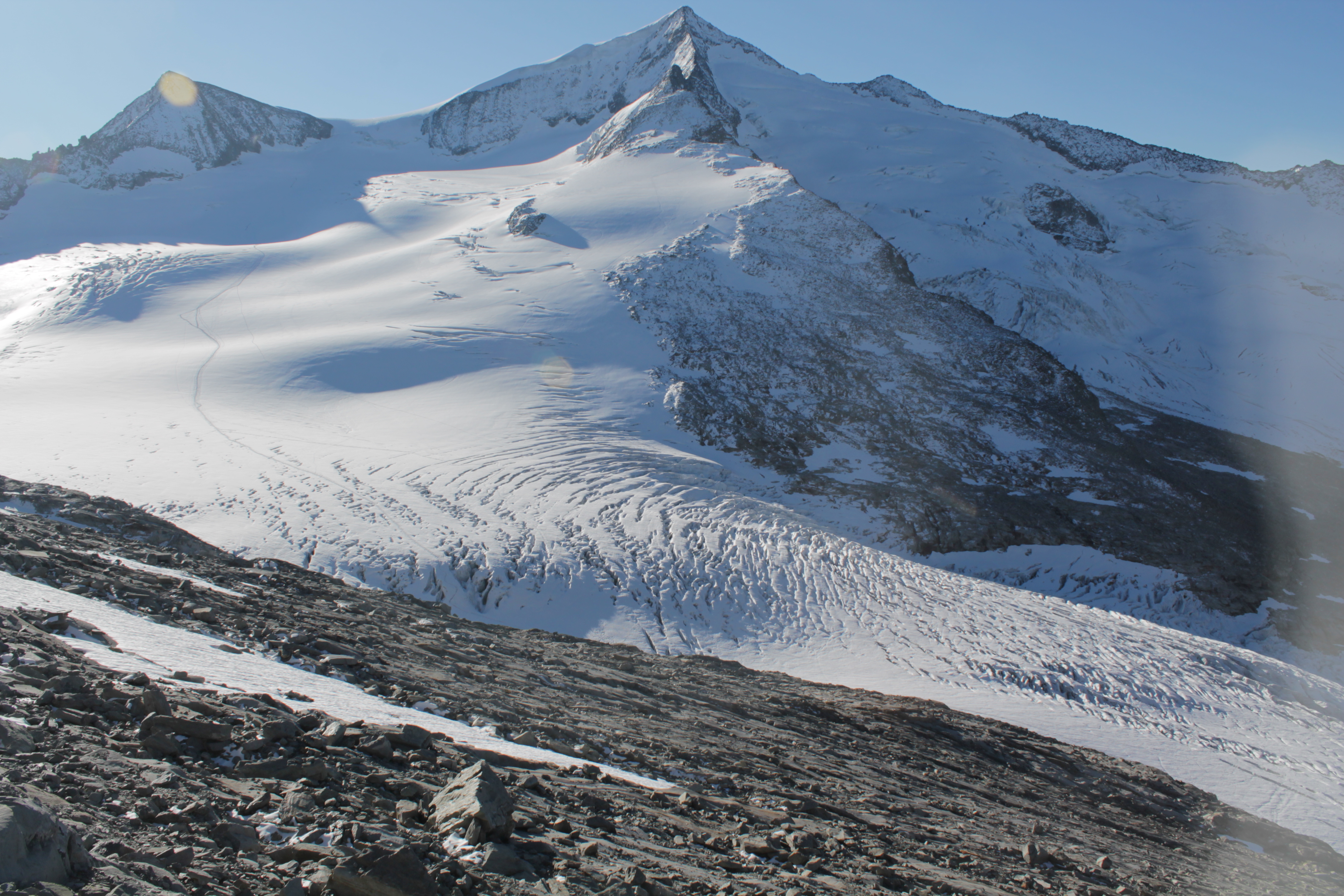
The Venedigerkees in the Hohe Tauern National Park is the easternmost tributary glacier to the former tongue of Obersulzbachkees. As a result of the strong retreat of Obersulzbachkees, the glacier disintegrated into several tributary glaciers, with a large lake remaining at the location of a famous serac zone, the 'Türkische Zeltstadt'. Mass balance of the Venedigerkees is measured since 2011/12 with the direct or glaciological method. Furthermore, an automatic weather station was built between Venedigerkees and Keeskogel in 2018.
-
The meteorological sensors are located on the roof of the main building of the Biological Station (N 47,7691; E 16,7662; Position (elevation): 122 msl) in the close vicinity of Lake Neusiedl. The parameters that are on-line recoded every 15 minutes are as follows: Air humidity (%RH), Global radiation (W/m²), Air temperature (°C), Wind speed ([Average] (km/h), Wind direction (°), Rain yearly (mm), Precipitation (mm); time resolution: 15 minutes. There are also two traditional weather stations at the station and on the jetty, which are maintained by the Hydrolographic Service Burgenland and enable parameters such as temperature, humidity, precipitation and water level to be recorded. In addition to the Adcon weather station on the roof of the station, there are currently 3 other stations in operation in Seewinkel. These positions are: • Unterer Stinkersee (N 47,8018; E 16,7842) • Neudegg (N 47,7029; E 16,8098) • Östliche Fuchslochlacke (N 47,7907; E 16,8624)
-
Mt Halla San is in Jeju Island, the only volcanic subtropical island, in South Korea. Every year the island is hit by several typhoons. It has shaped unique environmental characteristics and biodiversity. In addition the mountain is one of the most popular vacation sites with growing ecological concern.
-
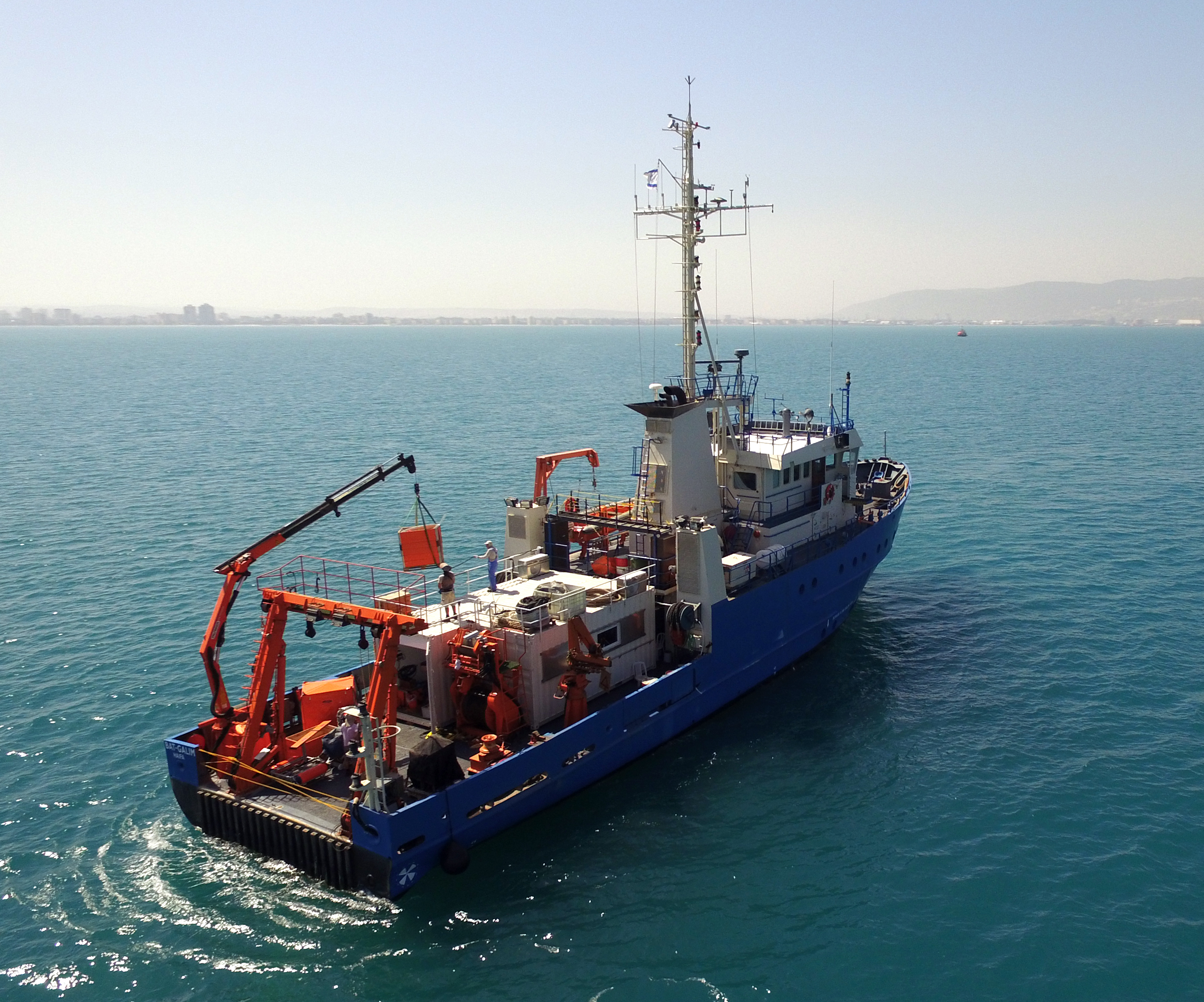
The National Institute of Oceanography (IOLR) is located in Haifa (Tel Shikmona) on the shores of the Mediterranean Sea. The institute engages in research and development in marine sciences and provides information and professional advice to the government and the public sector in the context of the sustainable utilization and conservation of Israel’s marine and coastal resources. The oceanographic studies at the institute are engaged in research, monitoring, and collecting environmental data in the Mediterranean Sea, and in studying natural and unnatural processes. The research topics at the institute include subjects such as; flow and mixing processes; oceanographic models; material cycles; sediment transportation and geological processes; the structure of the seabed; physiology, immunology, and ecology of marine organisms and the populations’ dynamics; the biological diversity in offshore waters and deep seas; effects of human activity on the open sea and coastal environment. IOLR operates advanced instruments and national infrastructures for marine research and monitoring, such as; the national research vessel “Bat Galim”, small ships, and autonomous underwater gliders. A variety of mapping, sampling, data collection, and independent systems are placed at sea for continuous monitoring of environmental variables. In addition, ecological monitoring (community structure, biological diversity, etc.) is carried out in several habitats at a monthly to yearly frequency as follows: • Seasonal ecological monitoring of the Benthos community of the vegetation tables in four sites from north to south since 2009 (also includes a monthly sampling of the water - chlorophyll, nutrients, alkalinity, DIC, temp., pH). • Seasonal ecological monitoring of the benthos community (fish, and biotic cover) of the shallow reefs in the Shekmona/Rash Carmel area. • Annual ecological monitoring of the mesophotic reefs (90-100 meters) at the top of Carmel and the shallow reef. • Monthly zooplankton monitoring at the Hadera station • Monitoring the fish society and the invertebrate community in sandy bottoms • Deep sea monitoring IOLR operates the National Marine Information Center - ISRAMAR, which collects, records, and distributes data and information regarding Israel’s marine environment.
-
Aquitain's karsts observatory (Aquitaine, France) regroups different karst sites located on the edge of the Aquitain sedimentary basin. These karst watersheds range from 0.01 km² (Lascaux cave) and 1 km² (Cussac cave) up to 100 km² (Toulon springs) and the land use consists of forests and agriculture under modified oceanic climate. This observatory consists of various observation and experimentation sites like patrimonial caves and large karstic hydrosystem outlets.
-
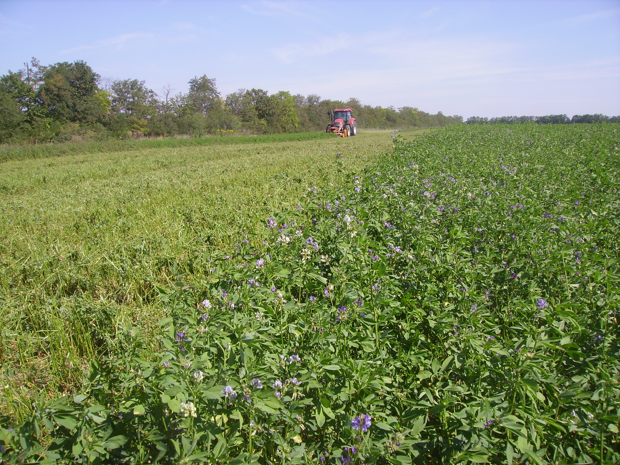
SITES Lönnstorp research station is situated in the Scanian agricultural landscape between Malmö and Lund and has a focus on the design, sustainable development and assessment of arable cropping systems, in conventional and organic farming. The research station is available for research within ecology, agronomy, environmental science, agroecology and other disciplines. SITES Lönnstorp research station have access to 60 hectares of conventional and 18 hectares of organic farm land, mainly cultivated with annual crops, representative for agricultural practise in southern Sweden. The station is also a part of SITES, Swedish Infrastructure for Ecosystem Science. SITES is a nationally co-ordinated infrastructure for terrestrial and limnological field research. In 2016, SAFE (SITES Agroecological Field Experiment) was established at the research station. SAFE make it possible to compare four different agroecosystems, a conventional reference system, an organic system, a perennial system and an agroecological intensified system.
-
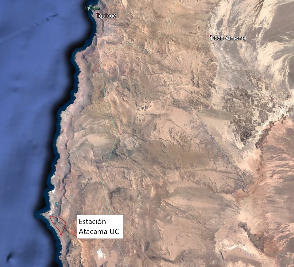
The Alto Patache fog oasis is located in northern Chile, 70 km south of Iquique, Tarapacá Region. This Oasis is located along the Coastal Range of Norte Grande, in the Atacama Desert, known for its remarkable aridity. The influence of coastal fog allows the development of a specially adapted vegetation, which provides habitat suitable for animal species.
-
The Rutzendorf Experimental Station is an agricultural research site of the University of Natural Resources and Live Sciences Vienna (BOKU), belonging to the Landwirtschaftliche Versuchswirtschaften GmbH. It is representative for the productive soils managed as arable land in the Marchfeld area (Lower Austria). The soil is described as a silty loamy Calcaric Phaeozem (WRB), a Chernozem according to Austrian soil classification. Management on the farm is without livestock, no organic fertilizers are applied. The farm was converted to organic farming in the production year 2002/03. The 8-year crop rotation comprises luzerne (2 yrs), winter wheat*, grain maize, spring barley*, field peas*, winter wheat, winter rye. Cover crop mixtures are grown where indicated in the crop rotation with an asteric. Current research questions include to study (i) the long-term sustainability and productivity of the stockless organic arable system compared to a livestock-keeping system, (ii) the mitigation of climate change effects on the soil-plant system by reducing soil cultivation intensity, and (iii) the development of biodiversity following the conversion to organic farming and enhancement of landscape elements. Regularly meteorological data, crop yields and quality, physical, chemical and biological soil traits, weed species and diaspores, springtails, wild bees and other animal species are assessed. Studies have been conducted as research projects financed nationally and by the European Union, e.g. in two EIP projects.