
microbial diversity
Type of resources
Available actions
Topics
Keywords
Contact for the resource
Provided by
Years
Formats
Representation types
-
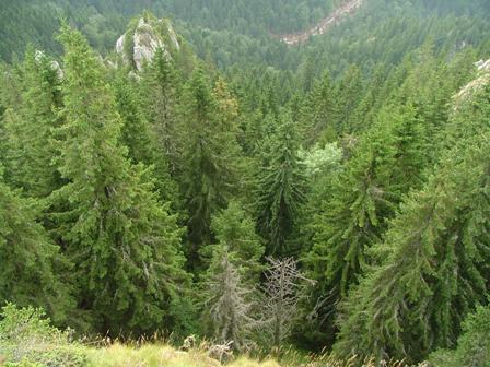
Kopaonik is the largest and the longest mountain range in Serbia located in its central part. It is proclaimed a national park in 1981. The observatory site in Kopaonik is located in strictly protected spruce forest, on the lower distribution of spruce zone on the border zone with beach forest. The mountain is characterized by alternating climate conditions; from warmer sub-mediterranean climate in the lowest part of the mountain to cold subalpine climate in high elevation areas. Vertical profile of the mountain with different climate zones and geological diversity resulted in high habitat diversity. The largest part of the area is covered by climatologically adapted mixed deciduous and coniferous forest having obvious zonal transition. A large number of endemic and relict plant species makes Kopaonik one of the most significant biodiversity centers in Serbia. Main threats to the area besides soil erosion present logging, deforestation and tourism.
-
The NEON site at the Oak Ridge National Laboratory (ORNL) is a 138.1-km^2 core terrestrial field site located in the Cumberland Plateau within Anderson and Roane Counties, TN. It is encompassed within NEON's Appalachians and Cumberland Plateau Domain 7, which includes the worlds longest expanse of hardwood-forested plateau. This domain is home to some of North America's greatest diversity of fish, mollusk, and wildflower species. ORNL is managed by a combination of the Department of Energy (DOE) and Tennessee Wildlife Resources Agency (TWRA). The Domain hosts four other NEON field sites, two aquatic and two terrestrial, three of which are located in Tennessee. Remote sensing surveys of this field site collect lidar, spectrometer and high-resolution RGB camera data. The flux/meteorological tower at this site is 127 with 6 measurement levels. The tower top extends above the vegetation canopy to allow sensors mounted at the top and along the tower to capture the full profile of atmospheric conditions from the top of the vegetation canopy to the ground. The tower collects physical and chemical properties of atmosphere-related processes, such as humidity, wind, and net ecosystem gas exchange. Precipitation data are collected by a tipping bucket at the top of the tower and a series of throughfalls located in the soil array. This site has five soil plots placed in an array within the airshed of the flux tower. Field ecologists collect the following types of observational data at this site: Terrestrial organisms (birds, ground beetles, mosquitoes, plants, small mammals, soil microbes, ticks), Biogeochemical data, and soil data. Total data products planned for this site: 119
-
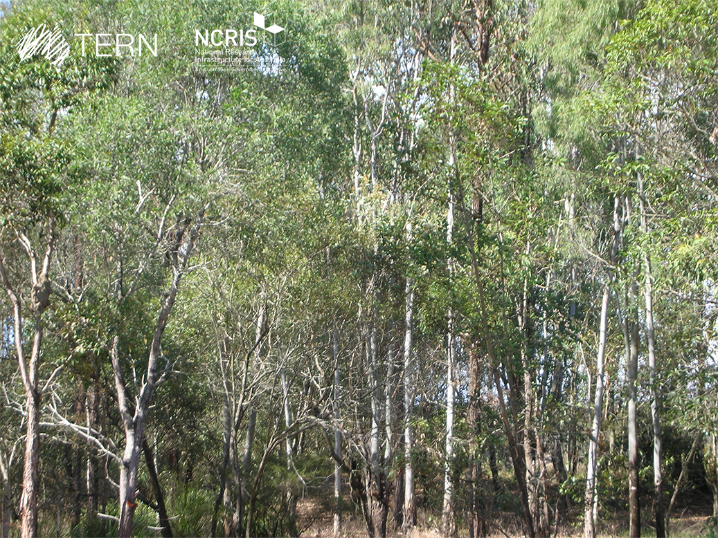
SEQ Peri-urban SuperSite - Karawatha is a member of the Australian SuperSite Network (SuperSites, http://www.supersites.net.au/), a facility within the Australian Terrestrial Ecosystem Network (TERN, http://www.tern.org.au/). SuperSites aims to answer both network wide and site-specific science questions through long term monitoring using both sensor technology and classical field methods. The SEQ Peri-urban SuperSite’s (SEQP) core infrastructure is located along two longitudinal transects north and south of Brisbane where the urban footprint is expanding the most rapidly. Karawatha Forest is on the southern peri-urban edge of Brisbane and is managed by the Brisbane City Council. It contains a variety of habitats from freshwater lagoons and sandstone ridges, to dry eucalypt forests and wet heath.
-
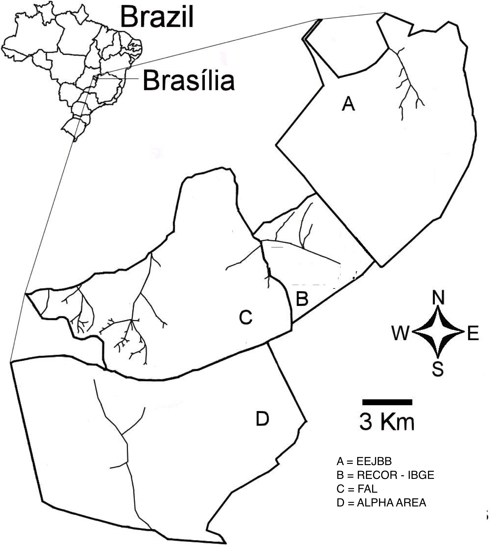
The “Área de Proteção Ambiental das Bacias do Gama e Cabeça de Veado” (AGCV) is located in the central area of the Cerrado domain in Brazil. This area of environmental protection is important due to its strategic localization as a buffer area between urban areas and the natural environments in DF, and by harboring hydric resources from two basins. There are three contiguous conservation units located inside the AGCV: Estação Ecológica do Jardim Botânico de Brasília (EEJBB; Ecologica Station of the Botanic Garden of Brasilia), the Reserva Ecológica do Roncador - IBGE (Recor - IBGE; Roncador Ecological Reserve) and Fazenda Água Limpa (FAL; Agua Limpa Farm, the ecological and agricultural field station of the Universidade de Brasília. In addition to those there is a contiguous 5,000-h area which is well-preserved, locally known as Alpha area. This latter and the three other conservation units are located 25 km SW of Brasília, Federal District, and together comprise about 15,000 ha in the core part of the Cerrado domain. A mosaic of Cerrado vegetation, including open vegetation, typical savanna formations, and forests occur in the region.
-
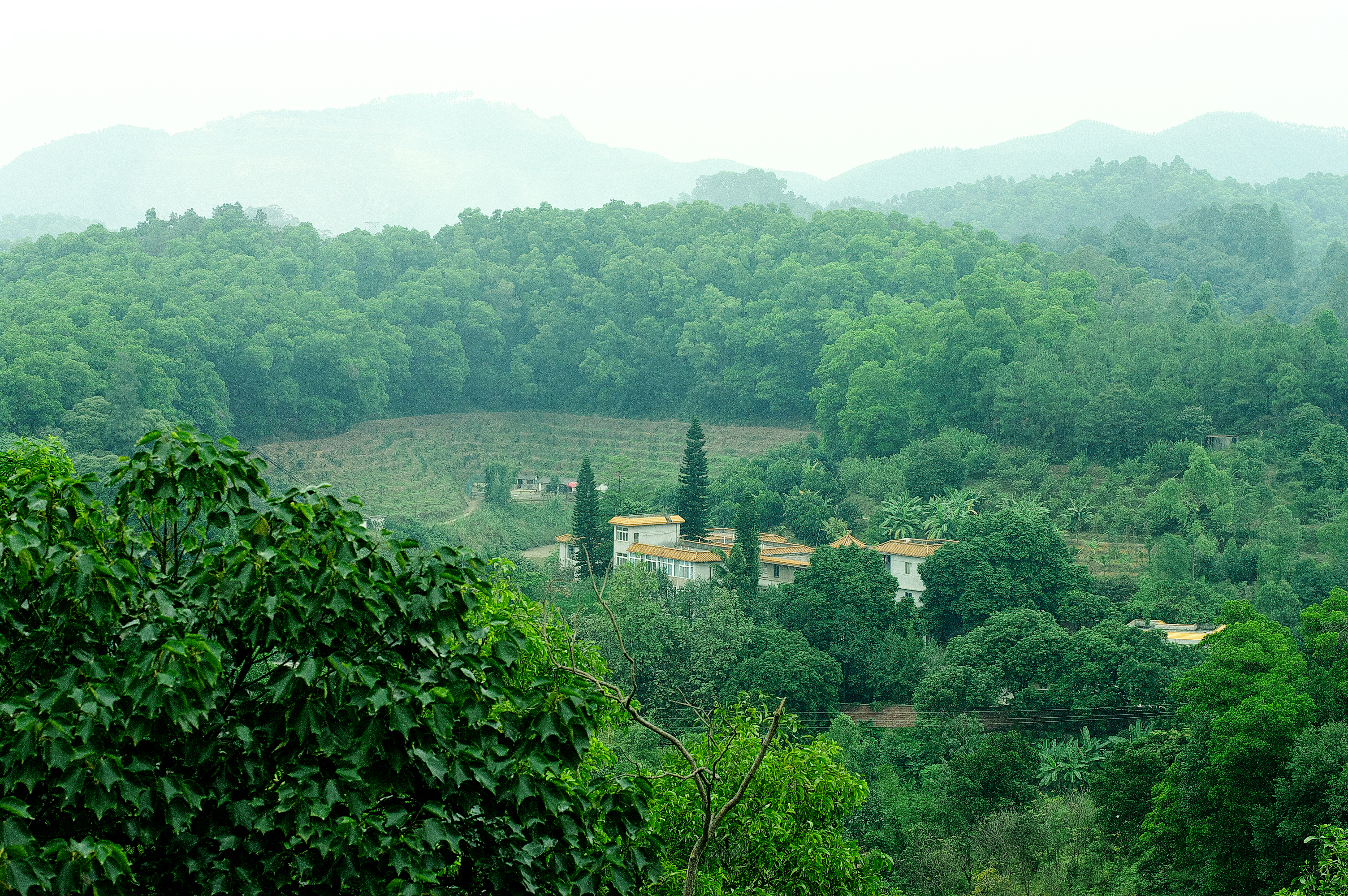
Heshan station (112 °54' E, 22 °41' N) is located in Heshan County, Guangdong Province, China. It is one of the core stations of the Chinese Ecological Research Network (CERN) of the Chinese Academy of Sciences (CAS.). The station was co-established by South China Institute of Botany (Renamed as South China Botanical Garden in 2002), CAS and Heshan Institute of Forest Science in 1984 based on the experience and knowledge of previous studies in a degraded costal ecosystem. Natural Conditions:The station is located in the central part of Guangdong Province with a typical climate of south subtropical monsoon. The soil is laterite. The mean annual temperature is 21.7 C, the mean rainfall is 1700 mm, and the mean evaporation is 1600 mm. The region is a hilly agricultural zone with 78.6% of hilly land, 17.1% of farming land and 4.3% of water body. The zonal vegetation is evergreen broad-leaved forest of typical subtropics. Research Areas:The research areas of the station include but not limited to the followings: 1) Study on canopy water flux of Acacia mangiun forest in the hilly lands of South China by applying sap flow technique; 2) Ecosystem carbon cycling; 3) Conservation genetics of cryptocarya chinensis population in lower subtropical fragmented forest; 4) N2O emission from main types of agricultural and forest lands in tropical and lower subtropical region of China; 5) comparative study on restoration progress between degraded tropical and subtropical ecosystems; 6) effects of landfills on soil biota and water quality; 7) impacts of forest composition on restoration progress; 8) mechanisms of adaptation of invasive species; 9) effects of girdling and defoliation on plant resource use efficiency and soil processes (root exudation, soil respiration and soil biota); 10) confounding effects of manure application on eucalyptus forest and on NEP (Net Ecosystem productivity); 11) nematodes as bio-indicators of different ecosystems.
-
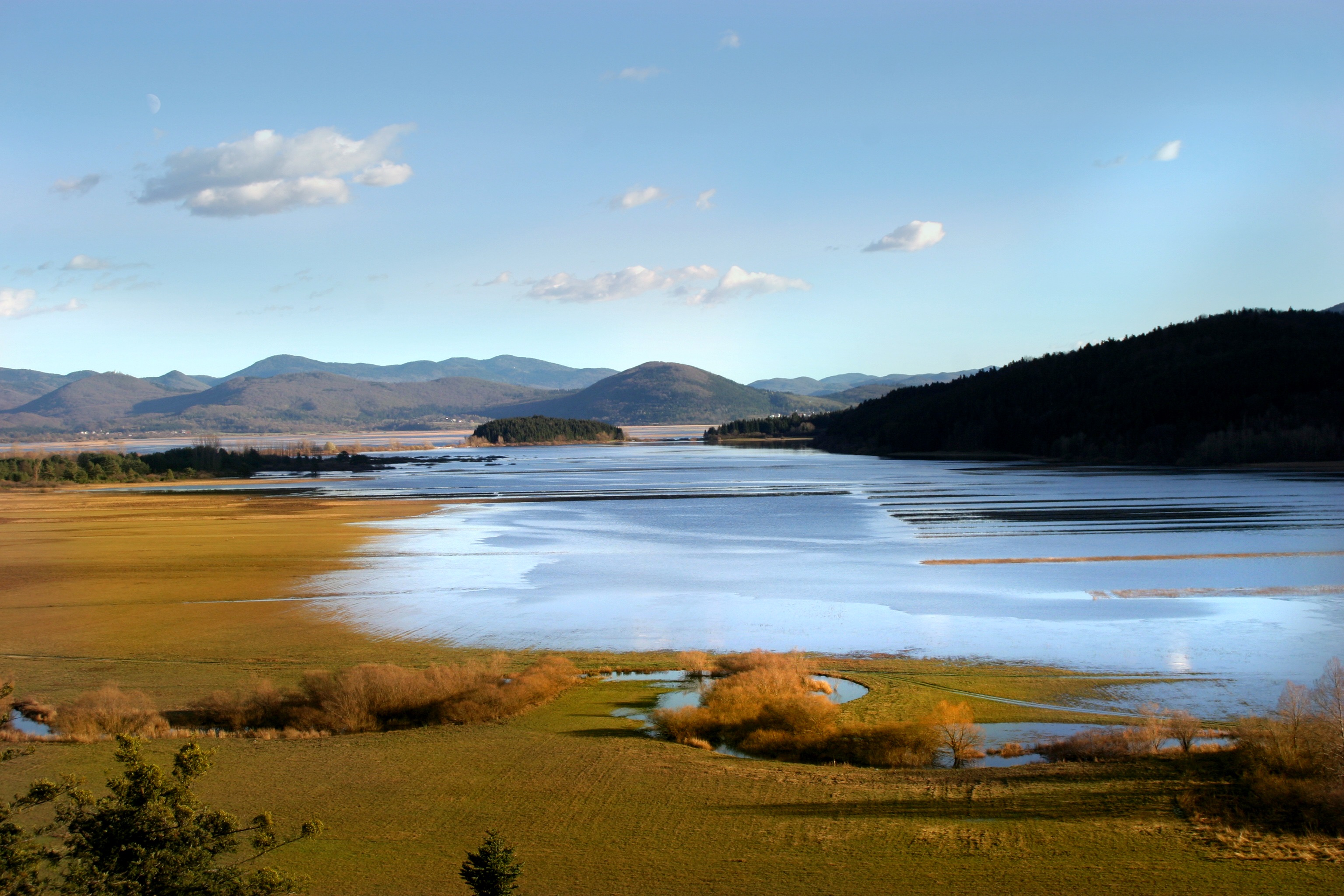
Lake Cerknica is intermittent lake appearing at the bottom of closed depression Cerkniško polje extending on the area of 38 km2. The karst features are associated with carbonate rock, both with limestone and dolomite. About 80 % of inflow consists of karst and only 15% of surface waters. The outflow is completely karstic. In spring and usually late in autumn the lake reaches normal level 550 m a.s.l., covering the area of 26 km2. Polje is flooded for 9 and dry for about 2 months, usually in summer. Lake Cerknica is a highly diverse ecosystem that changes in time and space. Vegetation pattern shows clear zonal distribution that depends on extent and frequency of flooding. The lake supports rich fauna with many endangered species, providing temporary shelters and food for protected large carnivores, such as brown bear, wolf, lynx and numerous species of water birds. In recent decades, flood and drought events have become increasingly irregular altering processes and conditions for many species.
-
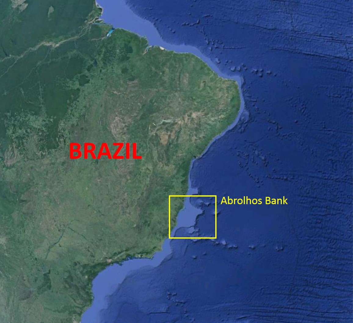
The Abrolhos Bank is located along the eastern Brazilian coast and is characterized by an enlargement of the Brazilian shelf (~46.000 km2), reaching approximately 200 km in width. The Abrolhos Bank encompasses three main megahabitats and a complex bathymetry. Rhodolith beds comprise the largest megahabitat, with 20,904 km² (43% of the mapped area), followed by unconsolidated sediments' megahabitat covering 19,151 km2 (39%) and by the reefal megahabitat with 8844 km2 (18%). Rhodolith beds and unconsolidated sediments are topographically less complex and form larger continuous extensions when compared to the reefal megahabitat, which is structurally complex and more patchily configured, even when examined at the regional scale.
-
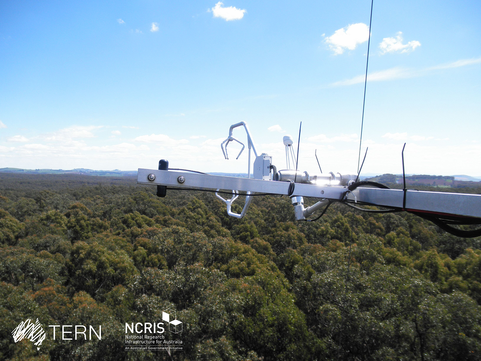
The Wombat Stringybark Eucalypt SuperSite is a member of the TERN Ecosystem Processes platform (https://www.tern.org.au/tern-observatory/tern-ecosystem-processes/), a field observatory within the Australian Terrestrial Ecosystem Network (TERN, http://www.tern.org.au/). The Wombat Stringybark Eucalypt SuperSite is located in the Wombat State Forest, Victoria, South Eastern Australia at an elevation of 713m. The site is a secondary re-growth forest that was last harvested in 1980. Dominant tree species are Eucalyptus obliqua (messmate stringybark), Eucalyptus radiata (narrow leaf peppermint) and Eucalyptus rubida (candlebark) with an average canopy height of 25 m. The understorey consists mainly of patchy grasses and the soil is a silty-clay overlying clay. The forest is managed by the Department of Environment, Land, Water and Planning and management includes selective harvesting and prescribed burning regimes. The climate of the study area is classified as cool-temperate to Mediterranean zone with cold and wet winters (May-Aug) and warm and dry summers (Dec-Feb). Key research objectives include: • What are the elements of structure, composition, functions and processes of the dry eucalypt forests of South Eastern Australia required for the sustainable management of these ecosystems? • What is the carbon sink/source strength of a dry sclerophyll forest and what is their contribution to Australia’s National Carbon Inventory? • What is the magnitude of emission and/or uptake of non-CO2 greenhouse gases, such as nitrous oxide and methane of dry eucalypt forest? • How will climate variability, drought or fire influence the ecosystem processes of dry eucalypt forest? The Dja Dja Wurrung peoples are the traditional owners at Wombat.
-
Los sitios están localizados a lo largo del bioma de pastizal semiárido que se extiende desde el norte del estado de Chihuahua, hasta la subprovincia geográfica de los Llanos de Ojuelos en el noreste de Jalisco. Todos exhiben una vegetación de pastizal semiárido dominado por gramíneas cortas del género Bouteloua. La topografía se caracteriza por llanuras, mientras los suelos predominantes están clasificados como xerosol háplico asociado a litosol y xerosol háplico asociado con litosol y planosol éutrico; estos suelos son someros (menos de 50 cm de profundidad). El tipo de uso histórico ha sido de pastoreo, aunque existen algunas áreas donde se realizó agricultura de temporal.
-
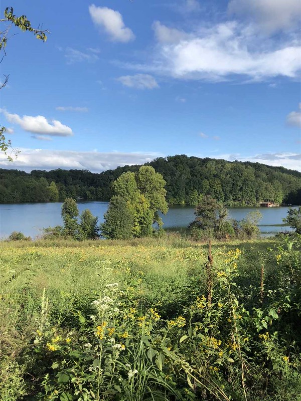
The Kellogg Biological Station (KBS) is located in southwest Michigan in the eastern portion of the U.S. cornbelt, 50 km east of Lake Michigan in the SW corner of the state (42° 24′ N, 85° 24′ W, elevation 288 m). Annual rainfall at KBS averages 1,005 mm/y with about half falling as snow; potential evapotranspiration (PET) exceeds precipitation for about 4 months of the year. Mean annual temperature is 10.1 °C. KBS is 1600 ha of cropping systems, successional communities, and small lakes. Surrounding KBS is a diverse, rural-to-semirural landscape typical of the U.S. Great Lakes and upper Midwest regions. The diversity of land use, soil and vegetation types, and aquatic habitats within a 50-km radius of the Station is high. Most of southwest Michigan is on the pitted outwash plain of the morainic system left by the last retreat of the Wisconsin glaciation, circa 12,000 years ago. Soils in the area developed on glacial till, and include well- and poorly-drained alfisols, mollisols, and entisols. Most regional soils are sandy loam and silty clay loam of moderate fertility, principal Station soils are Typic Hapludalfs. Land use around KBS ranges from urban (Kalamazoo, with a metropolitan population of 180,000, is 20 km south of the Station) to rural; vegetation ranges from cultivated and early successional old fields to older growth oak-hickory and beech-maple forests; and aquatic habitats include more than 200 bodies of water of different morphometries, alkalinities, and degrees of eutrophication within 50 km. Cropping systems in the area are typical of the U.S. cornbelt — mainly corn/soybean rotations with wheat of varying importance, and alfalfa an important forage crop. KBS yields are typical of non-irrigated yields elsewhere in the North Central Region. KBS LTER research is carried out in a variety of experimental systems. The most important of these is the Main Cropping System Experiment (MCSE), which was started in 1989 and consists of 11 different cropping systems or successional plant communities, ranging from annual corn-soybean-wheat rotations to late-successional deciduous forest. All communities are replicated within the landscape.