
nutrient concentration
Type of resources
Available actions
Topics
Keywords
Contact for the resource
Provided by
Years
Formats
Representation types
-
The Experimental Farm Groß Enzersdorf is a research and teaching facility of BOKU University of Natural Resources and Life Sciences, Vienna. It was founded in 1902 as a donation to the university by the Austrian emperor; it is a typical arable farm of 140 ha arable fields in Gross-Enzersdorf, Lower Austria. The farm is run in conventional agriculture, but 26 ha are converted to organic farming since more than 20 years. Another 35 ha acreage in Tulln, Lower Austria, plus 6 ha of experimental garden in the city of Vienna, 21. district, are additionally managed by the farm and available for experiments with arable crops, vegetables and fruit species. The experiments include two long-term field experiments that are descibed individually as related plots. These experiments are focussed on long term effects (i) of crop rotation and fertlization since 1906, and (ii) of soil tillage treatments since 1996. The whole farm beyond can be used for any kind of soil, plant or atmosphere observations in experimental settings, representing a typical Pannonian agricultural environment. It is equipped with complete sets of agricultural machinery for large scale farming operation as well as for small experimental plots. On the farm there is also a weather observation station installed by the Austrian Zentralanstalt für Meteorologie und Geodynamik (ZAMG).
-
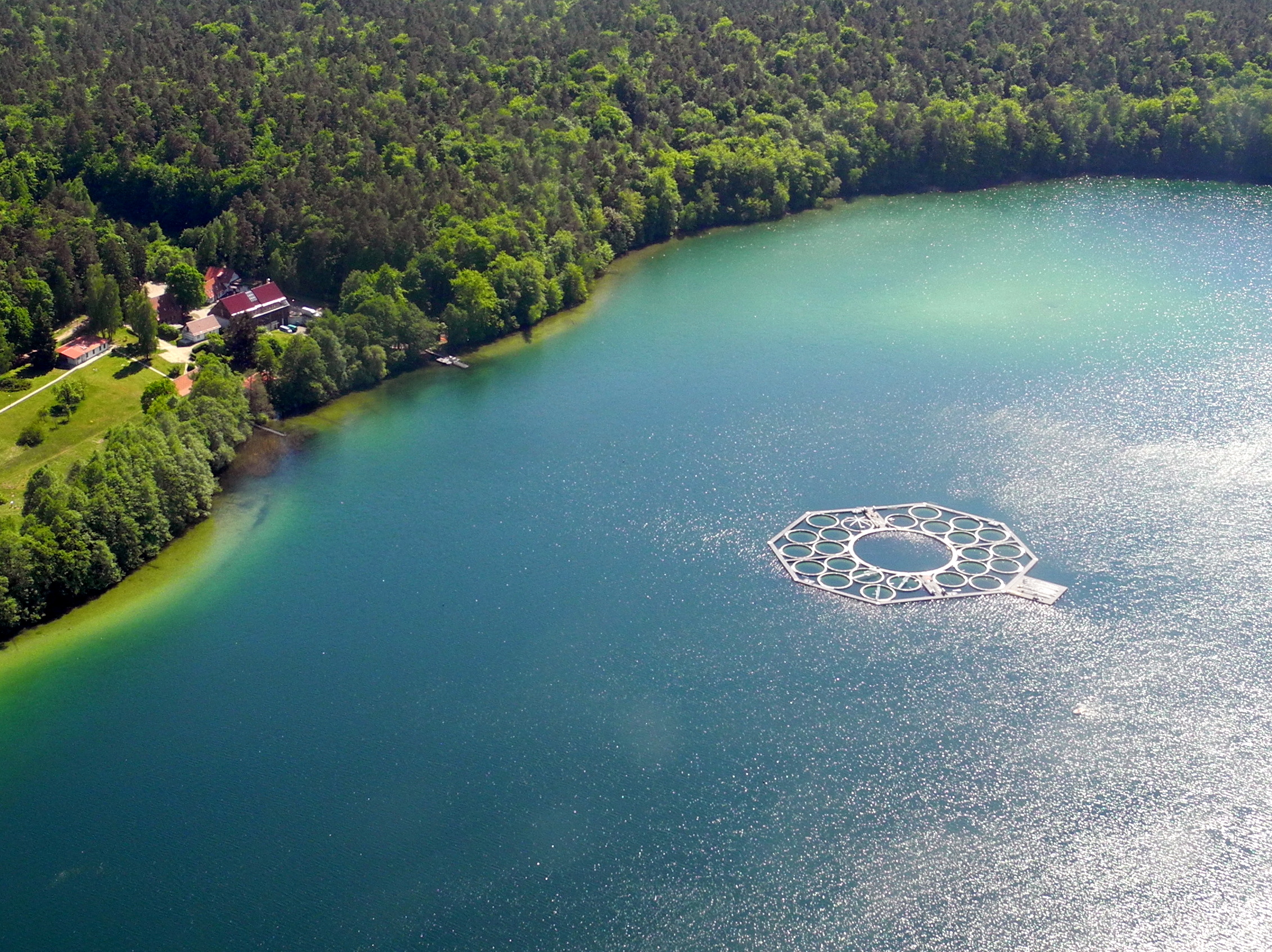
Measurements of lake chemistry are part of lake monitoring, which is usually carried out by monthly sampling at many regular lake sites (5 to 17 sites depending on the intensity of the measurements over the years). The integrated sample represents the whole water column of this polymictic shallow lake with a mean lake depth of 1.2m. The measurement satisfy the analytical standards of Ö-Norm in Austria.
-
Lake Stechlin is a a deep clear-water lake located in a nature reserve approximately 80 km north of Berlin, Germany (53°10°N, 13°02° E), at 59 m elevation.The lake basin was formed during the last continental glaciation some 12,000 years ago and today is situated at the transition between temperate/maritime and temperate-continental climates.The drainage basin is almost completely covered by forest (95%), with the exception of the area of a former nuclear power plant and a small village, which diverts its wastewater into a different drainage basin. The shoreline of Lake Stechlin is largely undeveloped with no notable infrastructure. The seepage lake is essentially fed by precipitation and groundwater, resulting in a theoretical water retention time of greater than 40 years.
-
Bidighinzu Lake is a warm monomitic and hypereutrophic reservoir located in northwestern Sardinia at 334 m a.s.l. Built in 1956, it is mainly used for drinking water for a population of about 160,000 users. Bidighinzu Lake covers a surface area of 1.7 × 10⁶ m² and has a maximum volume of 12.2×10⁶ m³ and a mean depth of 7.3 m. According to ECOSTAT, it belongs to the LM7 category (altitudes <800 m a.s.l., mean depths >15 m, conductivity <2.5 mS cm−1). Its watershed has a surface area of 52 km² with a geological substrate consisting of basalt, limestone, and shale. The supplies of water from the catchment to the lake are insufficient to make up for the losses and human demands. Consequently, the lake receives additional water from Temo Lake and Rio Mannu-Su Tulis river lock, localized in different watersheds. Problems of potabilization have arisen since the early years of the reservoir’s use, particularly in summer-autumn, because of hypolimnic deoxygenation and the excessive presence of algae in the epilimnion. To face this situation, different restoration actions were carried out in Bidighinzu Lake. Among the most important: the installation in 1966 of an aeration system in the area around the water intake tower and in 1987 the reduction of nutrient loads from the watershed by the diversion of civil and industrial wastewater downstream of the dam. A comparison among data collected from just before to about 10 years after this last action the site did not show any improvement in the trophic status. Since 2006, the lake is managed by the Sardinia Water Authority (ENAS) and is part of LTER-Italy. The site has real-time remote monitoring station equipped with a multiparameter probe housed on floating platform. The main scientific purposes at present concern the relationships between trophic status, abundance of cyanobacteria and the presence of toxins; the assessment of climate change and local factors on the phytoplankton dynamics; the development of territorial indicators related to the trophic conditions based on the land cover and use of catchment areas. Recently in Lake Bidighinzu it was conducted an experimental activity, with an aeration system with micro-bubbles. The aim was to maintain sufficient oxygen in the hypolimnetic waters, especially in the summer months, in order to improve the purification process, prevent phosphorus release from sediments and mitigate eutrophication. Available data sets include information on phytoplankton and limnological variables since the last 70.
-
In order to combat the eutrophication of Lake Balaton, the Kis-Balaton Water Protection System (KBWPS) was initiated in the early 1980s. Originally, the KBWPS consisted of an 18 km2 shallow (less than 1.3 m) artificial lake system (Lake Hídvégi) and a 16 km2 wetland, which were constructed on the site of the former Kis-Balaton wetland in the mid-1980s. Later, the wetland part of the KBWPS was significantly enlarged (over 50 km2). Lake Hídvégi was designed to retain nutrients and provide ideal conditions for algae growth, while the wetland component of the KBWPS prevented these algae from entering Lake Balaton. Regular limnological, ornithological, ichthyological and plant ecological measurements are carried out in both Lake Hídvég and the wetland part of the KBWPS.
-
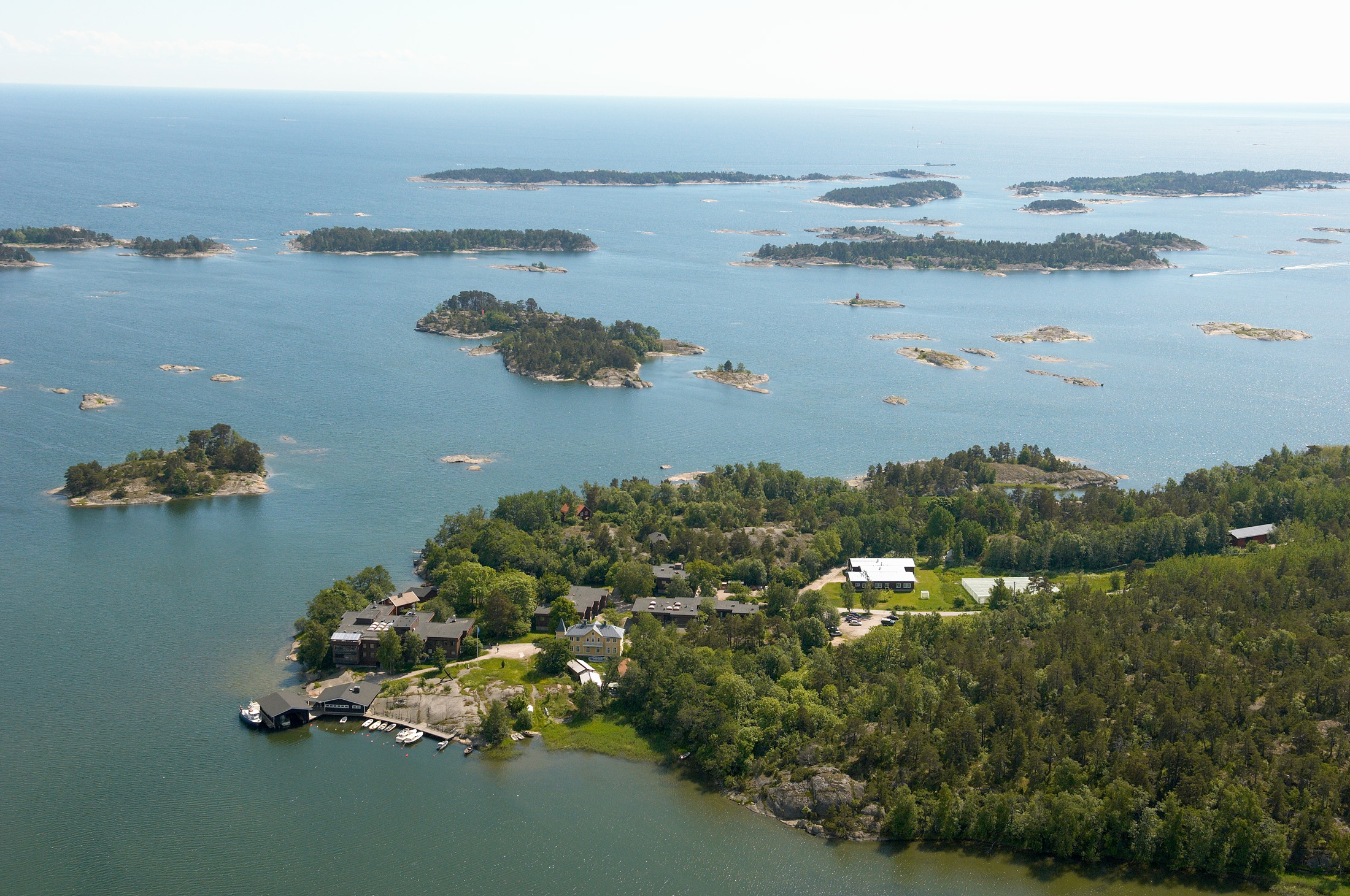
The WelFin LTER-site is located at the Hanko peninsula, at the entrance to the Gulf of Finland. The activities are largely focused to the coastal areas surrounding Tvärminne Zoological Station (University of Helsinki); a marine station established in 1902. The site is well equipped to meet the research demands, offering differently sized research vessels, field equipment, a range of climate chambers, and modern analytical instrumentation. A large part of the surrounding area is a nature reserve, to be used only for science and education. Many of the partners of this site have a long history of scientific collaboration. Although high-quality basic research continues to be at the heart of the site’s activities, many of the research questions nowadays include aspects of human induced long-term change.
-
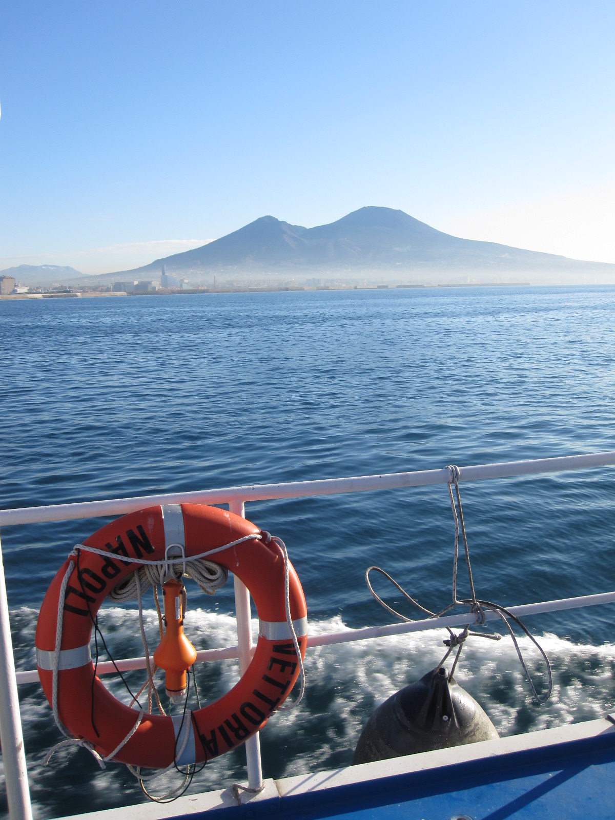
The Gulf of Naples has an extension of ca 870 kmq and an average depth of 170 m. The coastal area, which is inhabited since pre-Roman age, is densely populated and small factories are actively growing. In the Gulf, polluted areas (Sarno river mouth, harbours) coexist with pristine areas, including some Protected Marine Areas. Research on marine organisms has started before since the beginning of 1800, but first ecological studies date back to the 70ies of the last century. The long-term monitoring station (LTER-MC, 40°49’N, 14°15’E) is located 2 nm off Naples city (depth ca 75 m) at the boundary between eutrophied coastal waters and oligotrophic Tyrrhenian waters. Larger areas of the Gulf have been sampled occasionally in several cruises. The MC data set represents one of the few plankton time series available in the Mediterranean Sea, and it is certainly one of the longest.
-
The Baget catchment is managed by the Laboratory of Functional Ecology and Environment (EcoLab), a joint Research Unit between the Institute of Ecology and Environment (INEE) of CNRS, the National Polytechnic Institute of Toulouse and the University Toulouse III-Paul Sabatier, in collaboration with BRGM (Occitania regional agency), the laboratory Geosciences and Environment Toulouse (GET) and the Station of Theoretical and Experimental Ecology (SETE) in Moulis (Ariège, France). The Baget catchment (Pyrénées, Ariège, France) is a mountain ecosystem of middle altitude (Alt.= 1000 m) receiving around 1000mm of precipitation per year. Located close to Balagué village at 10 km West from Saint-Girons, the Baget catchment (13.25 km2) is drained by a karstic network which supplied the surface runoff of Lachein stream (specific discharge: 36 l.s-1.km-2). It is a tributary of the Lez which joins the Salat River, right tributary of the Garonne River. From 1968, this experimental site was intensively equipped by the CNRS underground Laboratory of Moulis (today SETE). The device is composed of one main weir at the outlet, 3 full excess controls, 3 piezometers of which one inside the abyss, and one subterranean loss. This karstic watershed has been surveyed since 1968 for some hydro-climatic parameters, particularly air temperature, precipitations and stream discharge at the outlet. Some geochemical parameters (pCO2, chemical and isotopic compositions of waters) and some hydro-biological and ecological data (invertebrates, particularly Crustacea) have been surveyed for periods during the last 40 years by the CNRS underground Laboratory of Moulis. Since 2011, Baget catchment belongs to the French Network of Catchments (RBV) and it is included in the certified National Observatory Service SNO Karst. Then, new parameters are measured twice a month or with higher frequencies during some flood events (major cations and anions, alkalinity, pH, conductivity, dissolved organic carbon, total suspended matter, H, O, C isotopes…). Since 2014, a multi-parameter probe has been installed with different sensors to measure continuously water level, pH, conductivity, turbidity, dissolved oxygen, nitrate and chloride. These continuous measurements are calibrated twice a month with laboratory analyses. The water discharge is measured by BRGM-Occitania because the Baget karst is part of the French patrimonial network of ground-waters and it belongs to the piezometric network managed by BRGM. The Baget catchment is very sensitive to limit conditions of surface drainage and to land covers. It offers the possibility to develop an eco-systemic survey, which integrates the hydrology, the geochemistry and the ecology of a mountain ecosystem in the SW of France. In this region, climate and land use changes will have significant impacts on biodiversity, ecosystem functioning and biogeochemical cycles for the next decades The Baget catchment is an international field site of the Critical Zone Exploration Network CZEN (http://www.czen.org/content/aurade-experimental-catchment) and it is one of the sites of the French SNO-KARST (Service National d'Observation) labellised by INSU-CNRS. It belongs to the French Research Infrastructure OZCAR and it is also a site of the French LTSER ZA PYGAR "Zone Atelier Pyrénées-Garonne".
-
Black Sea site includes three areas: cape Kaliakra, cape Galata and Varna Bay, and Koketrays Sand bank (only for macrozoobenthos). They were chosen on the base of historical data availability and eutrophication/pollution impact. Kaliakra marine area is influenced by eutrophication due to mainly the Danube river inflow. The local anthropogenic impact in the region is insignificant. It is a nature reserve. Cape Galata and Varna Bay sites are under the indirect impact of Varna Bay current and the system Beloslav lake-Varna lake - a cascade introducing nutrients and pollutants of industrial (chemical industry), agricultural, sewage origin and nearby ports. Koketrays Sand bank is an unique benthic habitat. The coordinates of the selected areas are as follow: c. Kaliakra: 28.416667 43.366667 c. Galata: 27.933889 43.186111 Varna Bay: 28.166667 43.166667 Koketrays bank: 27.888889 42.635556
-
The Morris Kahn Marine Research Station was established in order to provide baseline data and understanding of the marine ecological system in the Mediterranean Sea of Israeli coastal waters. The Charney School of Marine Sciences at the University of Haifa recently established a long-term ecological research station focusing on the eastern Mediterranean basin located in Kibbutz Sdot Yam, 44 km south of Haifa, near Caesarea. The station is called the Morris Kahn Marine Research Station and focuses on five main research topics; · Top Predators · Sediments · Water composition (Biogeochemistry) · Rocky Bottoms · Fish Disease (pathogens) The Israeli coastal area and the eastern Mediterranean Sea is experiencing accelerated development and infrastructure projects along the coastline, and a massive exploitation of marine resources never experienced in our region and nation. Coupled with the effects of global climate change and local polluting factors, life in the shallow and deep sea are changing rapidly. The Morris Kahn Marine Research Station is responsible for collecting biological and ecological data for long term research that will provide insight for understanding processes and predicting the effects of climate change and development on the environment. Such data will allow for science-based decisions that will greatly influence the interaction nature of future generations with the sea and the marine environment. This issue is particularly important given the fact that an majority of the water consumed in Israel is produced through desalinization of sea water, the main energy supply is based off of marine gas fields, aquaculture is gaining momentum as development allows for the cultivation of fish for human consumption in marine farms, and national projects referring to the sea as “developable land” that can be dried and made into artificial islands for various infrastructures. In order to accompany such a momentum in development without the collapse of the ecosystem and destruction of the sea as a natural resource, there is a need to provide reliable and in depth understanding as to how the system works. To accomplish these goals, the station employs top of the line researchers specializing in the Mediterranean as well as collaborate with other academic and research centres in Israel, while providing the best equipment for research and analysis of data collected from the sea including; · Rosetta collecting water samples from different depths · CTD device for measuring physical data of water · Advanced underwater photography and documentation equipment · Closed and controlled water system for aquaculture research · Device for detecting and quantifying nutrients in the water (Seal AA3). · Robot for measuring isotopes in samples (GC-IRMS-MS) · Confocal microscopy · Membrane mass spectrometer · Servers for database backup and maintenance · AAUS diving club performing scientific technical dives · Closed dive systems to allow deep, long, and safe dives · Boat used as a platform for diving and marine monitoring on the continental shelf · Laboratories for dissection · Work rooms for student and guest researchers · Meeting/conference rooms · AUV and ROV (Marine technologies lab) · THEMO buoy for deep sea research · Drones and other aerial devices · Website for sharing information as well as providing accessible information for the general public