
nutrient content
Type of resources
Available actions
Topics
Keywords
Contact for the resource
Provided by
Years
Formats
Representation types
-
The Experimental Farm Groß Enzersdorf is a research and teaching facility of BOKU University of Natural Resources and Life Sciences, Vienna. It was founded in 1902 as a donation to the university by the Austrian emperor; it is a typical arable farm of 140 ha arable fields in Gross-Enzersdorf, Lower Austria. The farm is run in conventional agriculture, but 26 ha are converted to organic farming since more than 20 years. Another 35 ha acreage in Tulln, Lower Austria, plus 6 ha of experimental garden in the city of Vienna, 21. district, are additionally managed by the farm and available for experiments with arable crops, vegetables and fruit species. The experiments include two long-term field experiments that are descibed individually as related plots. These experiments are focussed on long term effects (i) of crop rotation and fertlization since 1906, and (ii) of soil tillage treatments since 1996. The whole farm beyond can be used for any kind of soil, plant or atmosphere observations in experimental settings, representing a typical Pannonian agricultural environment. It is equipped with complete sets of agricultural machinery for large scale farming operation as well as for small experimental plots. On the farm there is also a weather observation station installed by the Austrian Zentralanstalt für Meteorologie und Geodynamik (ZAMG).
-
Measurements of lake chemistry are part of lake monitoring, which is usually carried out by monthly sampling at many regular lake sites (5 to 17 sites depending on the intensity of the measurements over the years). The integrated sample represents the whole water column of this polymictic shallow lake with a mean lake depth of 1.2m. The measurement satisfy the analytical standards of Ö-Norm in Austria.
-
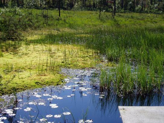
Coniferous forests and mire.
-
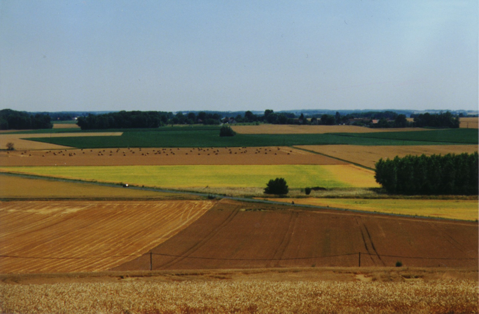
The ORACLE observatory is located 70 km East of Paris, France. Most of the area, in a sedimentary basin, is made of a relatively flat plateau (Alt. 140 m a.m.s.l.), which is incised by the Grand Morin and the Petit Morin rivers (Alt 100m). Several aquifers are associated with layered tertiary formations (Eocene and Oligocene). The Morin Rivers are affluents of the Marne River, known to have contributed to large historical floods in Paris in the 20th century. The observatory is mainly rural (76%) with small towns, villages and hamlets, the whole covering 7% of the area. Forests cover up to 20% of the area. The dominance of agricultural activity within the catchments means that diffuse pollution is regarded as the main environmental pressure. Several perennial device of environment observation are installed since 1962. This site is used for multivariable observations (water cycle, water quality, biodiversity, agricultural practices, sociology…) and multiscale observations (from the canopy to the aquifer, from one m² to 1200 km²). Temporary observations also exist, like soil property measurements, remote sensing data, depending on the specific collaborative projects between different research and operational units. These two observation approaches, the perennial and the temporary ones, are a real advantage to investigate environmental issues. The Observatory and its embedded sub-catchments allow to conceptualize the change in scale and to study sub-catchments with different behaviors.
-
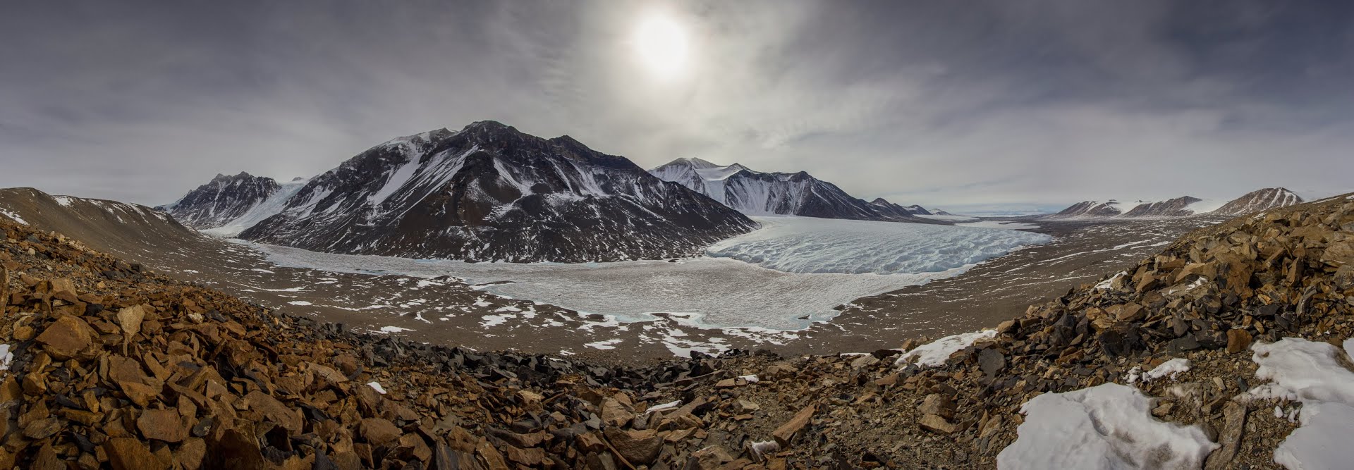
The McMurdo Dry Valleys (MDVs) (78°S, 162°E) represent the largest (4500 km^2) ice-free area on the Antarctic continent. The MDV landscape is a mosaic of glaciers, soil and exposed bedrock, and stream channels that connect glaciers to closed-basin, permanently ice-covered lakes on the valley floors. Mean annual air temperatures are cold (ranging from -15 to -30°C on the valley floors), and precipitation is low (~50 mm annual water equivalent as snow). Summer air temperatures typically hover around freezing and winter air temperatures are commonly < -40°C. While the water columns of the lakes are liquid and biologically active year round, glacial meltwater streams flow and soils thaw only during the austral summer. There are no vascular plants, but microbial mats are abundant in lakes and streams. Mat organisms are transported by wind onto glacier and lake ice surfaces where they actively metabolize in liquid water pockets (cryoconites) that form during the summer months. In the streams, which desiccate for ~10 months each year, cyanobacterial mats host extensive diatom and soil invertebrate communities. Lakes provide a habitat for diverse phototrophic and heterotrophic plankton communities that are adapted to annual light-dark cycles and temperatures near 0°C. Soils are inhabited by nematodes, rotifers, and tardigrades, all of which are metabolically active during summer. The McMurdo Dry Valleys LTER (MCM) began studying this cold desert ecosystem in 1993 and showed that its biocomplexity is inextricably linked to past and present climate drivers. In the fifth iteration of the MCM LTER program, we are working to determine how the MDVs respond to amplified landscape connectivity resulting from contemporary climate variation.
-
Lake Beyşehir, the largest freshwater lake in Turkey as well as in the Mediterranean basin, has a surface area of approximately 650 km2 and mean and max depth of 5–6 and 8–9 m, respectively. The catchment is situated in a semidry Mediterranean climate having an average temperature of 11 °C and an annual total precipitation of 490 mm during 1960–2012. In this period, precipitation values fluctuated between 317 and 716 mm (Beyşehir meteorology station, www.mgm.gov.tr), and the lowest annual average temperature was recorded in 1992 (8.5 °C) the highest in 2010 (13.1 °C). The catchment area of the lake is 4704 km2. The northern and eastern parts of the catchment are flat and intensively used for crop farming, while the western part of the catchment is dominated by mountains covered with forests and small areas of low-intensity agriculture. Nearly half of the catchment (42.7%) is covered by range-brush, 25.5% by agricultural land, and 13.5% by water (including Lake Beyşehir, the inflows, and wetlands), while forested areas (evergreen and deciduous forests) constitute 11.2%. The elevation ranges between 1027 and 2958 m.a.s.l., with an average elevation of 1370 m.
-
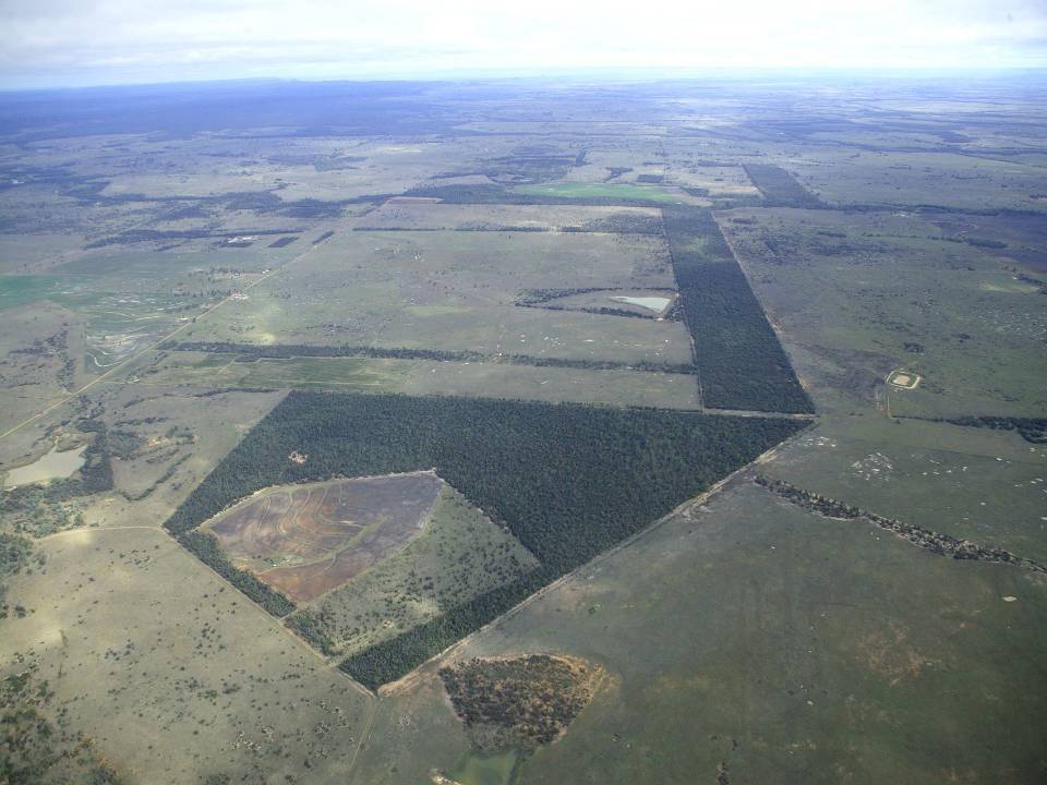
The aim of the Brigalow Catchment Study is to determine the effects of land clearing and land use change on hydrology, water quality, soil fertility and crop and animal productivity in the Brigalow Belt bioregion of central Queensland, Australia
-
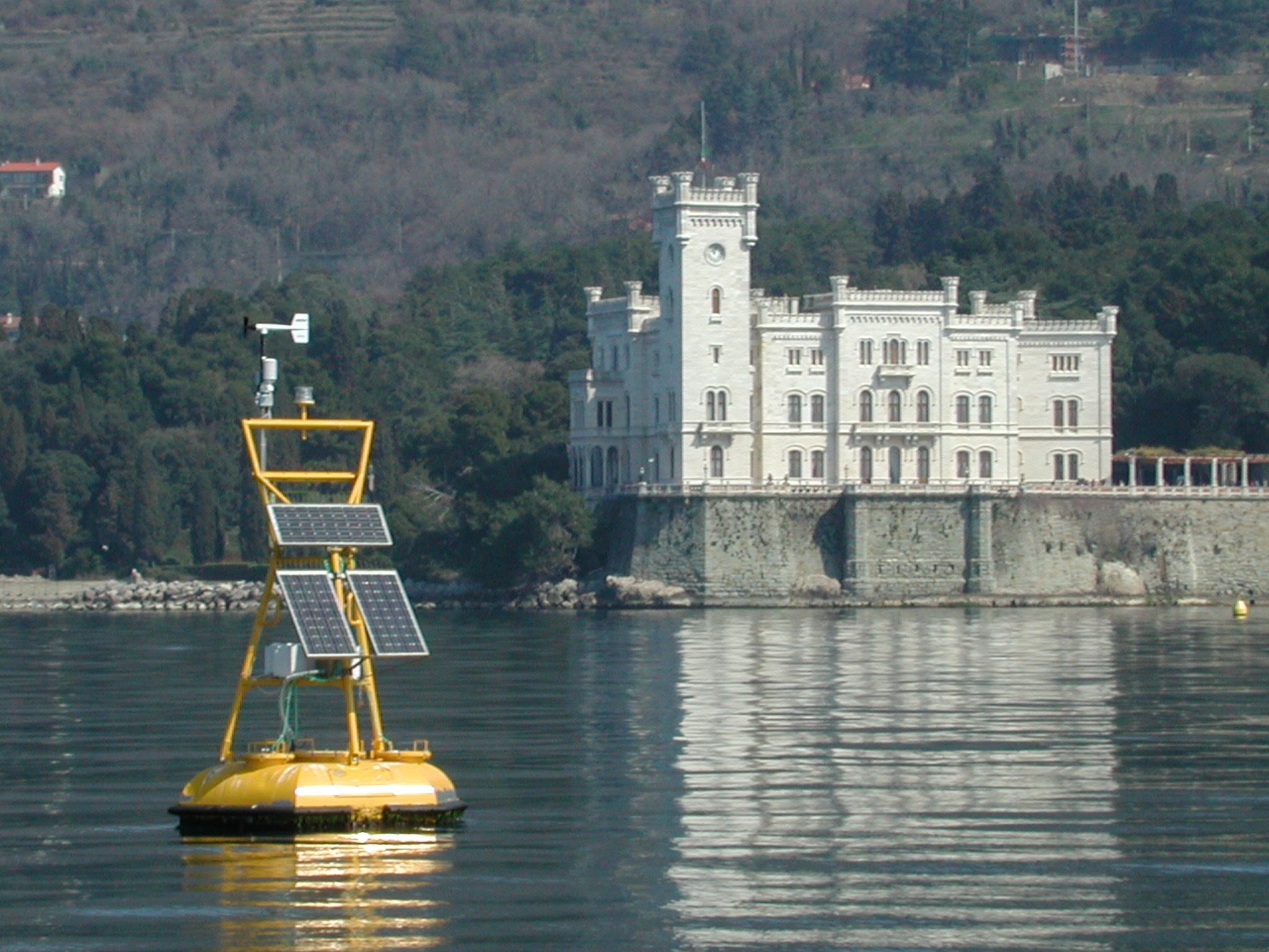
The coastal marine observatory site Gulf of Trieste lies within the Marine Protected Area (MPA) of Miramare and includes the biological time-series station “C1”, part of the Italian Long-Term Ecological Research (LTER) network, and the in situ continuous MAMBO meteo-oceanographic buoy. Marine Protected Areas represent one of the most effective systems for marine biodiversity preservation and management. Since 1986, the time-series station “C1” in the Gulf of Trieste (GoTTs, Gulf of Trieste Time series) represents a crucial site for marine ecological research, as it is subject to the interaction among several natural forcing (river, groundwater discharge, tides, general circulation, intense meteorological) and numerous anthropogenic activities (maritime transport, harbours of Trieste and Monfalcone, urban waste discharge, mussel- and fish-farming, fishing and recreational activities). In 1999, the ecological research site has been equipped with a meteo oceanographic buoy (MAMBO) in order to acquire continuous data on meteorological conditions at sea and on seawater physical and biogeochemical properties. Due to the high temporal dynamics of ecological processes in coastal ecosystems, continuous and real-time data of the main meteorological, physical and biogeochemical properties are fundamental for a better understanding of marine ecosystem functioning.
-
Mixed lowland and upland catchment established as a major UK research platform for ecological research, including long-term monitoring of greenhouse has fluxes and water quality, ecosystem-scale experiments, ecological and biogeochemical process studies and modelling. The Conwy catchment incorporates a range of habitats broadly representative of Wales, comprising upland bog and heath, mountain grassland, lowland improved grassland, conifer and broadleaf woodland.
-
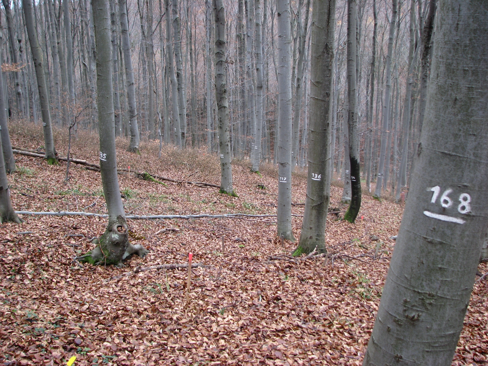
The site Klausen-Leopoldsdorf is part of the European Level II Forest Monitoring System in the frame of the International Co-operative Programme on Assessment and Monitoring of Air Pollution Effects on Forests (ICP Forests). The site was established in 1995 and is, since 2006, part of the LTER Austria network. It is situated in a homogenous 80 years-old managed beech stand about 20km west of Vienna. The LTER-CWN research area in Klausenleopoldsdorf is divided into 3 subplots: a measuring weir, a dendrometer/sapflow measuring facility and GHG-chambers for measuring the fluxes of CO2 and other relevant GHG´s. All 3 subplots were installed in 2019 to collect high-resolution data. The measuring weir is located at about 475m a.s.l and the other subplots (denrometer/sapflow, GHG measuring chambers) are located at about 510m a.s.l. The observed catchment of the measuring weir has an area of 46 hectares. The dominating soil types in the catchment are Planosoils and Stagnosols. The subplots are situated in the near vicinity of the ICP-forest plot.