
phenotypic variation
Type of resources
Available actions
Topics
Keywords
Contact for the resource
Provided by
Years
Formats
Representation types
-
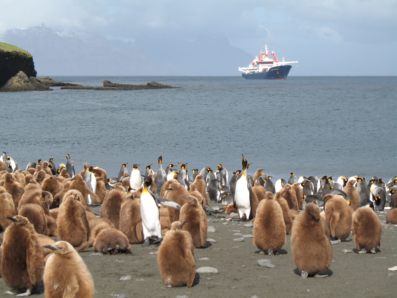
The LTSER Zone Antarctique belongs to LTER-France network and is located in Antarctica (Adelie Land), French sub-Antarctic Islands (Crozet archipelago, Kerguelen Islands, Saint-Paul et Amsterdam Islands) and southern ocean. General information below concerns Kerguelen Islands. The ZATA measures the impacts of climate change and human activities on antarctic and sub-antarctic ecosystems.
-
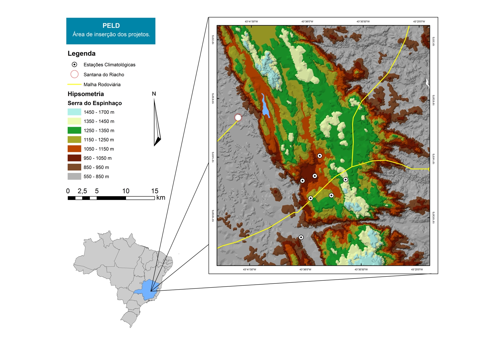
For over 20 years as a team of Long Term Sites in Serra do Cipó PELD-CRSC has been working to answer crucial questions of evolutionary ecology and provide a basis for understanding the spatio-temporal ecosystem functioning and it is future challenges with changes in climate and land use.
-

Berchtesgaden National Park was established in 1978 and is the only German national park located at the Alps. It comprises three major valleys and covers an elevantional range from 600 to 2700 m. Ecosystems include montane mixed forest and subalpine coniferous forest, alpine grasslands, pastures and rocky habitats. The Department for Research and Monitoring is linked to the Techincal University of Munich. It conducts monitoring on climate, hydrology, ecosystem dynamics and biodiversity. Main research topics include drivers of natural ecosystem dynamics, human impacts on ecosystems and climate change effects on ecosystems.
-

The Cairngorms National Park is one of 15 National Parks in the UK (one of two in Scotland) and is Britain's largest National Park (4,528 km2). It is the location for some of the most spectacular landscapes in Britain and is home to an incredible diversity of wildlife and plants. http://cairngorms.co.uk/the-park/facts-figures/ The aims of the National Park are: • To conserve and enhance the natural and cultural heritage of the area; • To promote sustainable use of the natural resources of the area; • To promote understanding and enjoyment (including enjoyment in the form of recreation) of the special qualities of the area by the public; • To promote sustainable economic and social development of the area’s communities. Cairngorms National Park, seven broad habitats can be identified: • Enclosed farmlands • Woodlands • Open waters (rivers, lochs, wetlands and floodplains) • Mountains • Moorland • Semi-natural grasslands • Urban • Population of c17,500 • 25.8% of population over 60 (higher than Scottish average) • Average health index in top 25% of Scotland (based on deprivation indices) • Extensive core paths network • 55 Munros including 5 summits over 4000 feet • 3 ski centres • National Cycle Network Route 7 • 1 Long Distance Route (Speyside Way) • Relatively low atmospheric pollution • Annual precipitation over 2250mm on summits and under 900mm in straths • Average annual snow cover 200 days on summits and 50 days on low-ground • Prevailing winds from south-west
-
The Zöbelboden was established in 1992 as the only Integrated Monitoring station in Austria under the UN Convention on long-range transboundary air pollution (CLRTAP). In 2006 it became part of LTER Austria. The Zöbelboden covers a small forested catchment (90 ha) of a karstic mountain range (500 to 950 m above sea level) in the Kalkalpen National Park. Monitoring and research is focussing on climate change effects on forest ecosystems, the forest carbon and nitrogen cycle, biodiversity, and air pollution effects on forested catchments. The Zöbelboden represents one of the best known karst catchments in Europe with long-term data series of the major components of its ecosystems. The site is part of many national and international monitoring and research networks (ICP Integrated Monitoring, EMEP, LTER, forestREplot, SoilTemp, LifePlan, IG-L, EU NEC-D, etc.). The Zöbelboden is managed by the Environment Agency Austria with technical support of the Kalkalpen National Park and the Austrian Federal Forests.