
plant distribution
Type of resources
Available actions
Topics
Keywords
Contact for the resource
Provided by
Years
Formats
Representation types
-
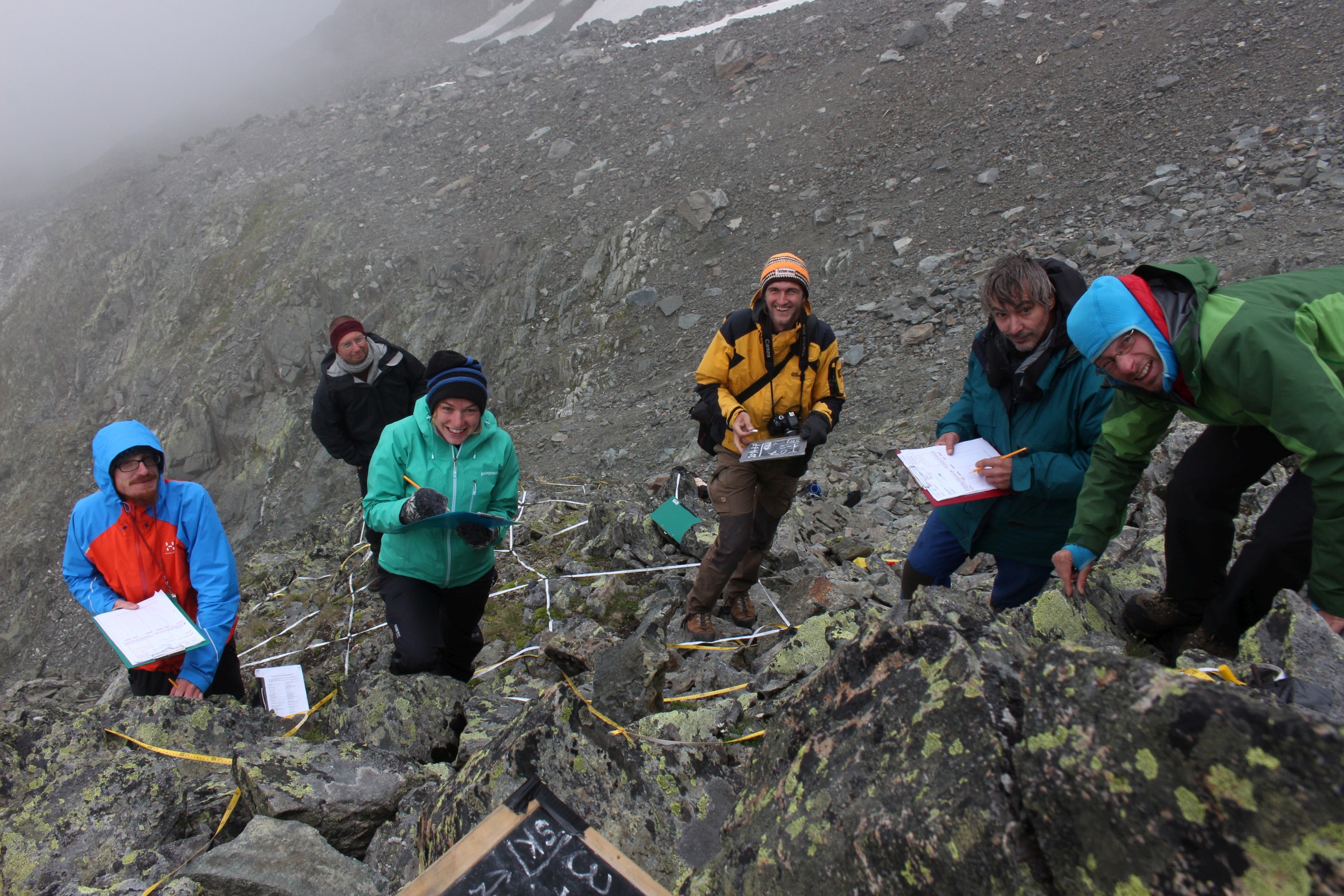
GLORIA Master Site.The 3497m-peak Mount Schrankogel belongs to the highest mountains of the Austrian Alps. Its northern and eastern side is surrounded by glaciers and glacier forelands. Its southern to western faces, however, are not interrupted by glacier Established in 1994 as the first comprehensive alpine to nival long-term monitoring site for high-altitude vegetation in the Alps, with ca. 1000 permanent plots of 1x1m arranged in transects of 30x3m or smaller ranging from 2900m to 3450m. Main purpose is ecological climate impact research. In 2001 it became a master site of the GLORIA network: e.g. method development and testing for species recording in 1x1m plots for GLORIA was partly conducted on Schrankogel. The first major resurvey of plots was made in 2004, the second resurvey was conducted in 2014. Besides long-term monitoring, several other research approaches were/are carried out at the Schrankogel site, such as species and vegetation modeling, vegetation mapping, phenological studies of alpine and nival plants, exclosure studies for grazing impacts at the lower altitudes of the site, soil studies, snow pattern studies (two permanent snow cameras), surface and soil-temperature measurements. In 2014, the the scope was extended to other organism groups such as soil microbiota, soil mesofauna (Oribatida and Collembola in particular), and surface-dwelling arthropods. Site setup, resurveys, or other activities were/are supported by: the Austrian Academy of Sciences through a national grant of the International Geosphere–Biosphere and the UNESCO MaB Programmes, by the Austrian and through the Institute of Mountain Research (IGF) of the Academy; by the Austrian Federal Ministry of Science and Research; the Austrian Federal Ministry of Agriculture, Forestry, Environment and Water Management; the Swiss MAVA Foundation; the Government of Tyrol; the project ALARM (Assessing Large-Scale Risks for Biodiversity with Tested Methods; No. GOCE-CT-2003-506675) in the FP-6 of the EU; the Austrian Climate Research Programme (ACRP: GZ B368633 ACRP6 - SCHRANKOGEL_20YEARS - KR13AC6K11076). For further details on Schrankogel_GLORIA see: http://www.gloria.ac.at/?a=42&b=56
-
None
-
Socio-ecological interactions in ecosystems of mid-altitude mountains The LTSER Zone Atelier Arc Jurassien belongs to LTER-France network and is located in eastern France.The LTSER site Jurassian Arc (ZAAJ stands for Zone atelier Arc jurassien, in French) is designed to promote long-term interdisciplinary research into the environment and ecosystems in relation to society issues. It federates a network of research partnerships around interactions between the environment, society and the dynamics of moutain socio-ecological systems.ZAAJ helps to capitalise on field data and to analyze and promote the results from long-term observation schemes at the interface between ecology, the environment and society. Benefiting of more than 25 years of experience on the issue, accredited by the CNRS Ecology and Environment Institute (INEE) in 2013, ZAAJ is a cluster of five research units totalling 40 researchers.
-
The Jornada Basin Long-Term Ecological Research (LTER) program is part of a national network of long-term ecological research sites funded by the US National Science Foundation (NSF). The Jornada LTER program has been continuously funded since 1982 to develop general principles governing changes between grassland and shrubland ecosystems based on long-term data collected in the Chihuahuan Desert. Research themes at the Jornada LTER focus on vegetation change, climate and land use impacts on ecosystem function, and the role of dryland processes in structuring communities and landscapes. We translate our findings to dryland ecosystems around the world, and forecast the dynamics of future ecosystem states in response to changing climate and land use. The Jornada Basin is located in southern New Mexico, USA, approximately 25 km northeast of the city of Las Cruces (32.6 N -106.7 W, elevation 1315 m). Annual precipitation is 24 cm and maximum temperatures average 13 C in January and 36 C in June. The study site is near the northern extent of the Chihuahuan Desert, which is the largest of the North American warm deserts, in a region has undergone large shifts in the relative dominance of grasslands and shrublands over the past century. We partner closely with the USDA-ARS Jornada Experimental Range (JER) and the NMSU Chihuahuan Desert Rangeland Research Center (CDRRC), allowing us to benefit from a long history of rangeland research, and to contribute to science-based management and sustainability practices.The Jornada Basin LTER project is administered by New Mexico State University.
-
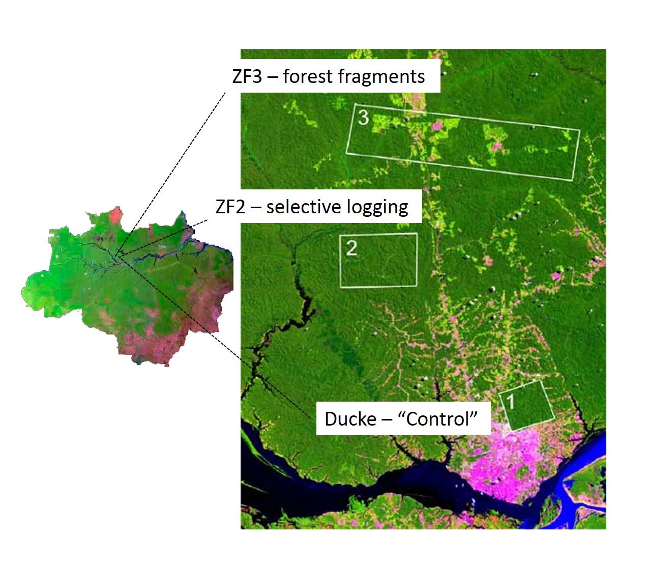
The LTER IAFA site has been running since 1999 and was the first long-term ecological research site in the Amazon. It is situated north of Manaus, central Amazon and includes three sub-sites, with undisturbed terra-firme forest (Reserva Ducke), selective logging (ZF-2 Forest Management Station), and forest fragmentation (Biological Dynamics of forest fragments – BDFFP sites) spread over around 30 x 30 km landscape. Both logging and fragmentation were carried out as controlled experiments to test their effects on biodiversity and ecosystem processes, and thus to outline recommendations for management. The 3 research areas together have 156 permanent monitoring plots, both terrestrial and aquatic, as well as grids of trails for large-scale process monitoring. The information produced has been stored on a public website (https://ppbio.inpa.gov.br/repositorio/dados) where anyone can search data and metadata about the research, as well as the list of publications and all the educational material ( books, identification guides, training course materials) for download.
-
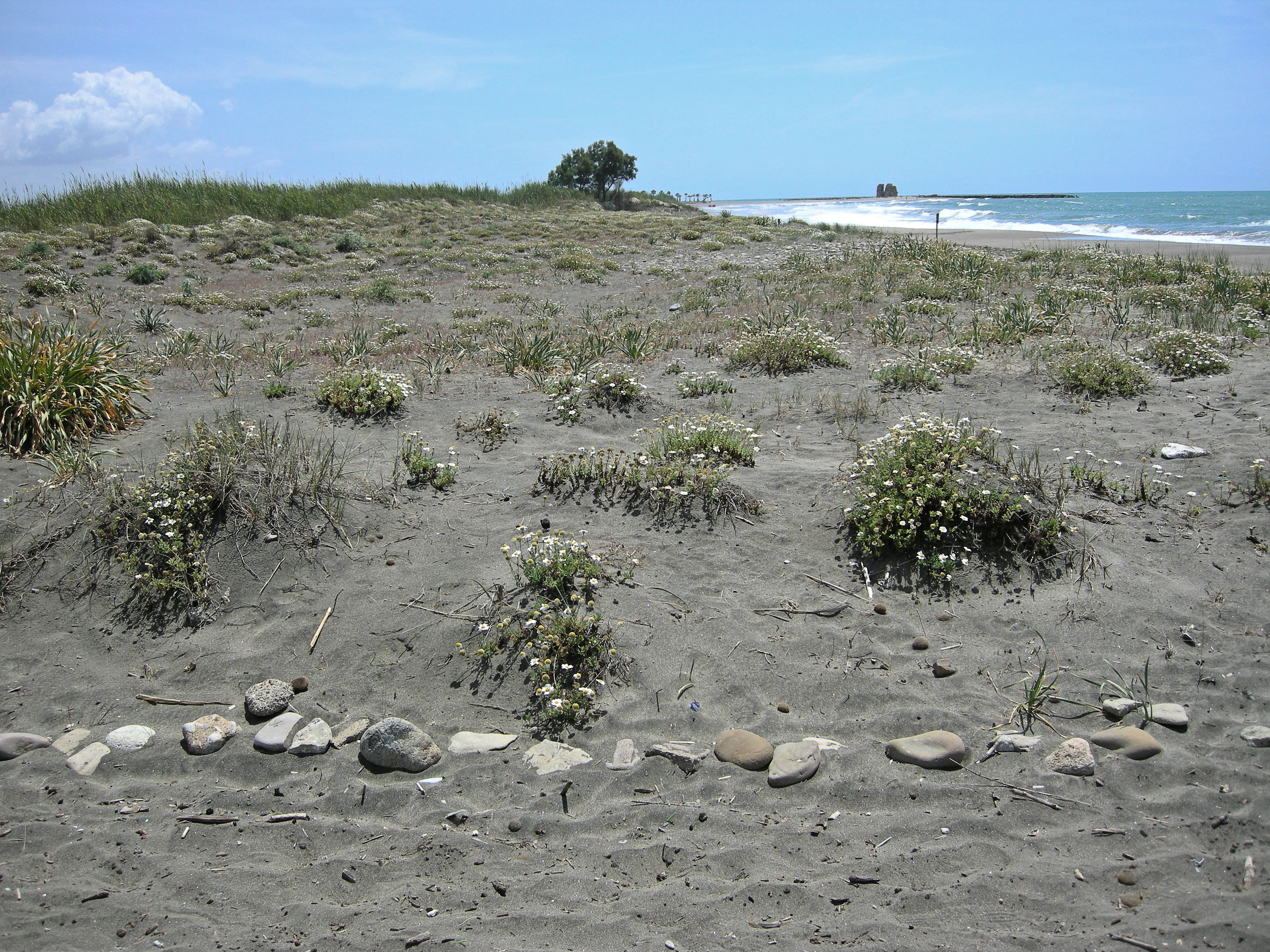
The site, located along the Tyrrhenian coast, north of Rome city, is a Special Protection Area (SPA) for migratory and nesting birds (Anatidae, Ardeidae). The wetland area is one of the last stretches of the Lazio wetlands which have been progressively reclaimed and cultivated during the last century. The flora and the fauna of the site is not only highly specialized but also highly endangered, with a relevant ecological value evidenced in previous studies. The site includes coastal dune habitats of European interest, as the annual vegetation of drift lines, the embryonic shifting dunes, the mobile dunes with Ammophila arenaria and the dune grasslands. There are also habitats related to wet and mud soils, as Mediterranean salt meadows and reed beds dominated by Phragmites australis.
-
The Yatsugatake-Kawakami Forest of Mountain Science Center, University of Tsukuba, consists of three forest areas: the Yatsugatake Forest (80 ha) located in Minamimaki, Nagano Prefecture, Japan, the "Megumi-no-Mori" (14 ha) on the campus where the administration building is located, and the Kawakami Forest (189 ha) located in Kawakami, Nagano Prefecture, Japan. The Yatsugatake Forest is 1400-1450 m above sea level, and the Megumi-no-Mori is 1350 m above sea level. The forest is characterized by gentle slopes without remarkably topographic change and a mosaic of secondary deciduous broad-leaved forest dominated by oak (Quercus crispula) and Asian black birch (Betula davurica), and intermediate moor characterized by thatch herb (Moliniopsis japonica) and Japanese alder (Alnus japonica). Rare plants such as primrose (Primula sieboldii) and drosera (Drosera rotundifolia) are also found here. Black soil is distributed throughout the Yatsugatake Forest and Megumi-no-Mori. The Kawakami Forest is located between 1360 and 1700 m above sea level. 70% of the forest area is planted with Japanese larch (Larix kaempferi). The rest is a secondary deciduous broadleaf forest dominated by oak and birch. Some of the forests are dominated by a beech (Fagus crenata) stand, a natural Sawara cypress (Chamaecyparis pisifera) stand, and spruce (Picea alcokiana) stand. The forest is covered with brown and black soils, and the topography of the forest is more varied than that of the Yatsugatake Forest, including ridges and valleys. In the Kawakami Forest, an ecological survey of forest mammals is also being conducted. At these three forests, education and research are conducted on ecological surveys of trees, rare plants, and wildlife (population dynamics and conservation ecology), forest meteorological observations, and artificial forest management and operation.
-
Rich fen and grassland communites formerly used for haymaking in the transition between the middle boreal and northern boreal vegetation zone, and in the transition between oceanic and continental vegetation sections in Central Norway
-
LTER plot Thermophilous forests includes five regions and sixteen localities in Central Bohemia and Southern Moravia, where ecosystems of thermophilous forests, including adjacent natural treeless vegetation, have been studied for a long time. The monitoring is run jointly by the Institute of Botany of the Czech Academy of Sciences (coordination R. Hédl) and the Silva Tarouca Research Institute for Landscape and Ornamental Gardening (coordination D. Adam). The main focus is on the plant community, including trees and herbs, which are monitored by using sets of permanent plots, or as continuous forest stands. Data are collected at the level of individuals (plants), plant communities (species composition and biodiversity) and ecosystem (soil, canopy, microclimate and other variables). The backbone of the monitoring system consists of nearly 500 long-term monitoring plots. These are supplemented by several dozens of short-term monitoring plots, and historical plots resurveyed only once after several decades. The monitored forest stands share similar natural conditions and management history. They cover a wide range of thermophilous forest communities, mainly thermophilous oak-hornbeam forests, various types of oak and ravine forests, occasionally beech forests and the adjacent open habitats (rocky steppes). The dominant type of management was coppicing in most sites, mainly as coppices-with-standards. The historical management was abandoned during the 19th and early 20th centuries, and the monitored ecosystems were managed with a decreasing intensity in about the past half a century. Some of the localities or their parts are subject of non-intervention regime at present. This has affected the age of the forest stands, which has increased by several times. Today, many stands are 100+ years old. All monitored localities are parts of conservation areas, often multiple combinations - national nature reserves (NNR), national nature monuments (NNM), nature reserves (NR), national park (NP), protected landscape area (PLA), EU Site of Community Importance (SCI). The main strategy of the nature conservation is the management reduction at most sites. In several cases, however, restoration of the traditional ways of forest management has been introduced in the past years. The Thermophilous forests site consists of the following five areas and sixteen localities: 1. Křivoklátsko Protected Landscape Area Monitoring of the dynamics of tree communities (including 3D scanning), vegetation including the communities of vascular plants, fungi, saproxylic beetles and soil processes. Data are available from 1976, 1999, 2004 and annually since 2004 (localities Velká Pleš and Týřov), or since 1993 (locality Červený kříž) - Velká Pleš: 10 ha of continuous forest stand monitoring, 400 microplots (20 x 20 cm) and monitoring of game impact on rocky steppes (pleše = balds). - Týřov: 400 microplots (20 x 20 cm) in xerothermic treeless habitats and in enclosures. - Červený kříž: focus on the impact of game on the diversity of plant communities. 2. Český kras Protected Landscape Area Monitoring of the dynamics of plant communities, soil and tree overstory in five-year intervals, using a network of 190 permanent plots. Microclimatic measurements in part of the plots. Data from 2005, 2009, 2014, 2019. Focus on the tree dynamics at one locality (Doutnáč). Part of the area left for spontaneous development, part subject of the traditional management restoration. Additionally, 57 historical vegetation plots resurveyed after 50 years. - Karlštejn NNR: three localities Prostřední vrch, Vysoká stráň and Doutnáč; collective area 166 ha. - Koda NNR: three localities Tobolský vrch, Za lípou and Kodská stěna, collective area 95 ha. 3. Podyjí National Park Monitoring of the dynamics of several forest ecosystem components, focusing on natural processes and the restoration of traditional management forms. Continuously measured tree stands, yearly monitoring of plant communities, invertebrates, bryophytes, snails, fungi and soil variables by using a network of plots. Data available from 2010 and 2014-onwards. A network of 50 permanent plots with five-year monitoring interval was established in 2018. - Four localities in the eastern part of the national park: Lipina, Šobes, Popice and Hnanice, collective area 309 ha. 4. Pálava Protected Landscape Area Monitoring of the dynamics of plant communities, soil and tree overstory in five-year intervals, using a network of 160 monitoring plots. Microclimatic measurements in part of the plots. Monitoring of spider, beetle and ant communities in addition to that. Data available from 2008-onwards. Next to it, about 230 historical vegetation plots resurveyed after 50-60 years, and a detailed research on the management history. - Děvín NNR: 380 ha, 85 permanent plots and about 180 resurveyed historical plots. - Milovický les: 2051 ha, 75 permanent plots a 46 resurveyed historical plots. 5. Dúbrava Monitoring of the dynamics of plant communities, soil and tree overstory in five-year intervals, using a network of 75 monitoring plots. Data from 2011, 2012 and 2017. In addition to that, 56 historical vegetation plots resurveyed after 50 years, covering a larger area. Detailed research on the management history and a paleoecological research covering the entire Holocene. - Hodonínská Dúbrava: 4820 ha, 75 permanent plots and 56 resurveyed historical plots.
-
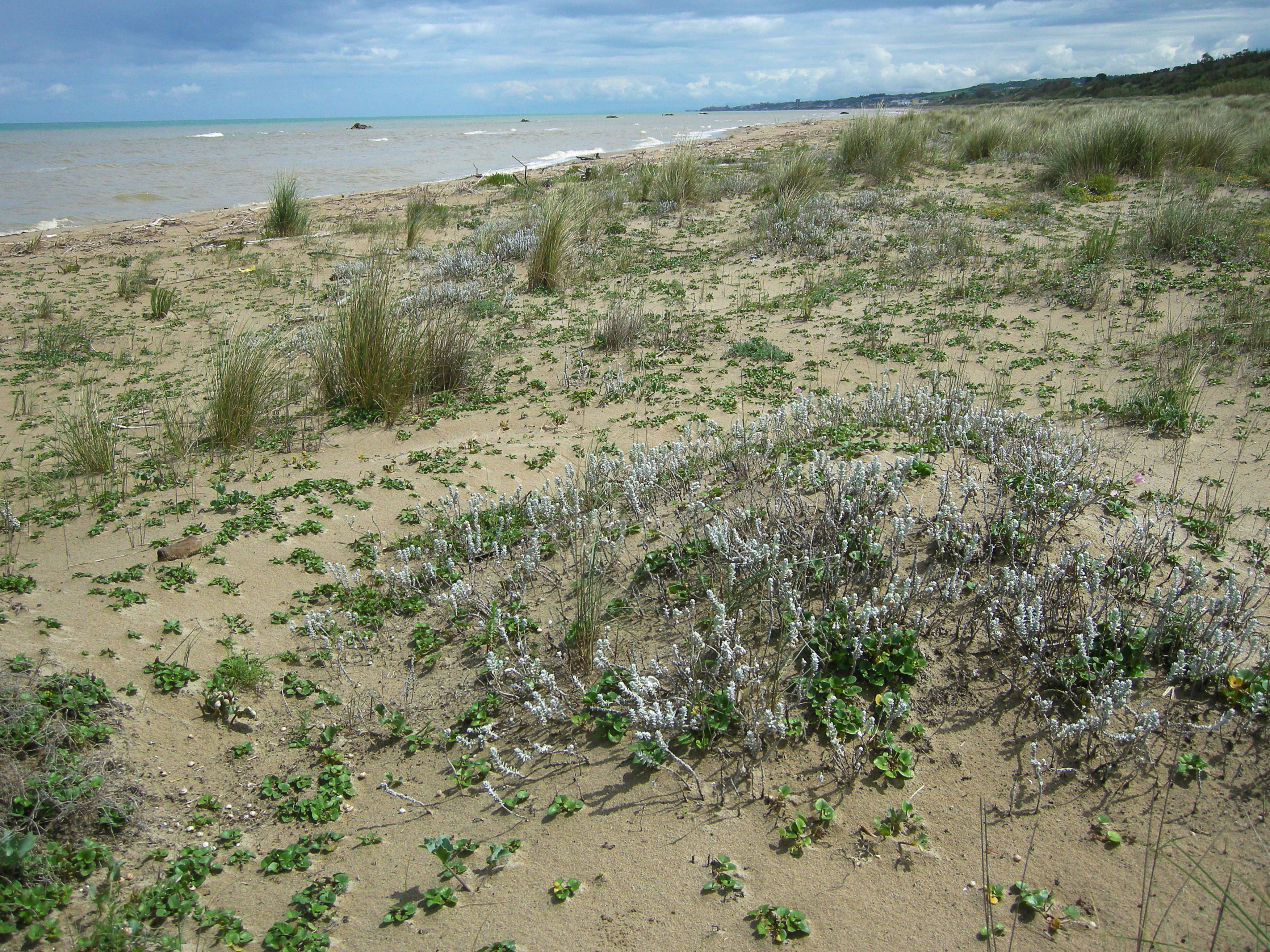
S.C.I IT7228221 Foce Trigno-Marina di Petacciato (Campobasso) S.C.I. IT7140108 Punta Aderci-Punta della Penna S.C.I. IT7140109 Marina di Vasto The site includes 3 Natura 2000 sites along the central Adriatic coast, where the last fragments of natural vegetation zonation on sand coastal dunes occur (shore vegetation, embryo and mobile dune vegetation, annual Mediterranean grasses and wet dune slacks).