
plant species presence
Type of resources
Available actions
Topics
Keywords
Contact for the resource
Provided by
Years
Formats
Representation types
-
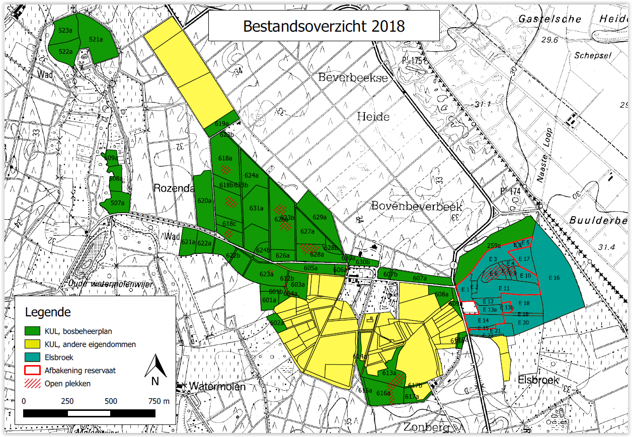
Beverbeek is a complex site consisting of areas with a primary conservation purpose as the two gazetted nature reserves Elsbroek (mesotrophic and oligotrophic mire with alder-birch woodland, Myrica bush) and Zooren (alluvial plain forest). Other parts are multifunctional forests with scots pine, corsican black pine, oak, larch, douglas fir, etc.
-
UK Upland Waters Monitoring Network (UK UWMN) site. Loch Coire Fionnaraich has a catchment of 550 ha, with a range of elevation from 236 m at the outflow to 933 m at the summit of Maol Chean-dearg. Whilst a band of Cambrian basal quartzite and "Pipe Rock" crosses beneath the northern side of the loch, the catchment geology is mostly made up of Torridonian sandstones from the Applecross and Aultbea groups. Catchment soils consist of peats and peaty podsols alongside extensive areas of exposed rock. Vegetation is dominated by Molinia and Calluna and the catchment is treeless. The surrounding moorland is managed for red deer and low numbers of feral goats are also present. A popular hiking path passes along the western shore of the loch. There are a number of very small lochans and pools on the catchment's northern boundary and one more in the north-west.
-
UK Upland Waters Monitoring Network (UK UWMN) site. Named Lochan a' Cheaird on historic maps, Loch Tinker lies at 418 m altitude and drains an adjacent catchment to the east of Loch Chon in the Trossachs region of central Scotland. The loch receives drainage from seepage through the catchment blanket peats and from the steep slopes to the south and east, although the main stream in this area is naturally captured just a few metres downstream of the loch outflow. The loch drains to the north east via the Allt Glasahoile which falls steeply to Loch Katrine. The loch (surface area 11.1 ha) has an irregular shoreline and the generally shallow (mean depth 3.5 m) bathymetry includes two distinct sub-basins reaching a maximum depth of 9.8 m. Three small islands are located towards the southern end of the loch. Some data managed by UK ECN Data Centre. Note: The area is the size of the catchment.
-
UK Upland Waters Monitoring Network (UK UWMN) site. Loch Chon is a relatively large (surface area 105.7 ha) lake lying at an altitude of 92 m in the Trossachs region of central Scotland. The loch is fed by several small streams and drains to the south via Loch Ard and the River Forth. The loch has two main basins, with the deepest area (25 m) represented by a trench near the western shore. The bathymetry was first surveyed by Murray and Pullar in 1910. Some data managed by UK ECN Data Centre. Note: The area is the size of the catchment. The lake area is 106 ha
-
UK Upland Waters Monitoring Network (UK UWMN) site. The site lies at 298 m altitude in the Galloway region of south-west Scotland. The loch is 12.7 ha in area and receives drainage from minor streams and catchment blanket peats. The outflow drains to the south-west into the Glenhead Burn and Loch Trool. The loch bathymetry indicates a single deep basin (maximum depth 13.5 m) offset to the south with slopes rising gently away from the southern shore. An island is located just off the western shore some 250 m from the outflow. Some data are managed by UK ECN Data Centre. Note: The area is the size of the catchment.
-
UK Upland Waters Monitoring Network (UK UWMN) site. Blue Lough is a small (1.9 ha) circular lake lying at 340 m altitude. The lough has no discrete inflow and drains through a Sphagnum bog to a tributary of the Annalong River. The bathymetry reveals a shallow concentric basin offset to the east, with a maximum depth of 5 m. Blue Lough is situated in a col between the Silent Valley and Annalong Valley in the Mourne Mountains of south-eastern Northern Ireland, very close to Bencrom River. The catchment is small (48 ha), but is steep and rugged, reaching a maximum altitude of 703 m. The solid geology of the catchment consists of granite which is exposed as bare rock and scree on the steep backwall and is covered with thin and often eroded blanket peat, peaty podsols and peaty gleys in the less steep areas. Bare rock, scree and eroded peat characterise the catchment, but elsewhere the vegetation is dominated by Calluna which in places is mature and in others has been intensively burnt. Land-use and management is restricted to low-intensity sheep grazing and occasional heather burning. Annual rainfall is c. 1600 mm. Some data are managed by UK ECN Data Centre. Note: The area is the size of the catchment.
-
UK Upland Waters Monitoring Network (UK UWMN) site. Loch Grannoch is a large (surface area 111.4 ha), elongated lake which lies at 214 m altitude. Small streams feed the loch along its eastern and western shores, the principal of which is the Cuttimore Burn. It drains to the north into the River Dee via the Pullaugh Burn. The loch bathymetry was first surveyed by Murray and Pullar in 1910 and was updated by a subsequent survey by the Palaeoecology Research Unit of University College London. The major basin is offset to the south of the loch and reaches a maximum depth of 20.5 m. Some data are managed by UK ECN Data Centre. Note: The area is the size of the catchment.
-
UK Upland Waters Monitoring Network (UK UWMN) site. Llyn Cwm Mynach lies at 287 m altitude. The lake consists of two distinct basins; the southern section comprises a shallow limb separated from the deeper northern section by an old and broken stone causeway. The maximum depth of 11 m occurs in the northern basin in a localised hollow. Discrete drainage to the lake is by three small inflows and it is drained to the south-east by a small stream which flows to the Mawddach estuary. At some stage in the past a wooden weir (now derelict) was constructed at the outflow, presumably to raise the level of the southern section of the lake. Some data are managed by UK ECN Data Centre. Note: The area is the size of the catchment.
-
UK Upland Waters Monitoring Network (UK UWMN) site. Burnmoor Tarn is the largest 'tarn' in the English Lake District. It occupies 23.9 ha and lies at an altitude of 253 m in a moraine hollow on the uplands between Wastwater and Eskdale. The lake has two distinct basins close to the south-eastern shore and a maximum depth of 13 m. There are four main inflow streams to the north and north-west. The outflow at the eastern end joins the Hardrigg Beck which drains the slopes of Scafell and, in times of especially high flow, is partly diverted into the lake across a braided delta. Some data are managed by UK ECN Data Centre. Note: The area is the size of the catchment.
-
Central Europe maintains a considerable diversity of dry-mesic oak forests as the main representatives of zonal forest vegetation types in Hungary, covering the major part of foothills of the middle-range mountain, Inner Western Carpathians. The 669 m high, Triassic limestone hill called ‘Vár-hegy’ belongs to the Bükk Mountains. The annual mean temperature is about 8◦C and the annual precipitation is about 650 mm. The core area of the reserve (94 ha) is covered mainly by close-to-nature. long untouched oak dominated forests stands: Pannonic woods with Quercus petraea and Carpinus betulus; Pannonian-Balkanic Turkey oak-sessile oak forests; Pannonian woods with Quercus pubescens. It has been set aside for preservation in 1991, though several previous conservation acts had already secured almost spontaneous natural development of the stands. Most of the area was cut around 1880, however, several over-mature trees were retained. The intensive use in the previous centuries and during the world wars left a sessile oak dominated, 120-130-year-old, mostly coppice forest. The abandonment and the precedent severe oak decline contributed to generate a more diverse forest composition and structure developing towards a mixed forest with pronounced ‘old-growth’ characteristics.