
pore water content
Type of resources
Available actions
Topics
Keywords
Contact for the resource
Provided by
Years
Formats
Representation types
-
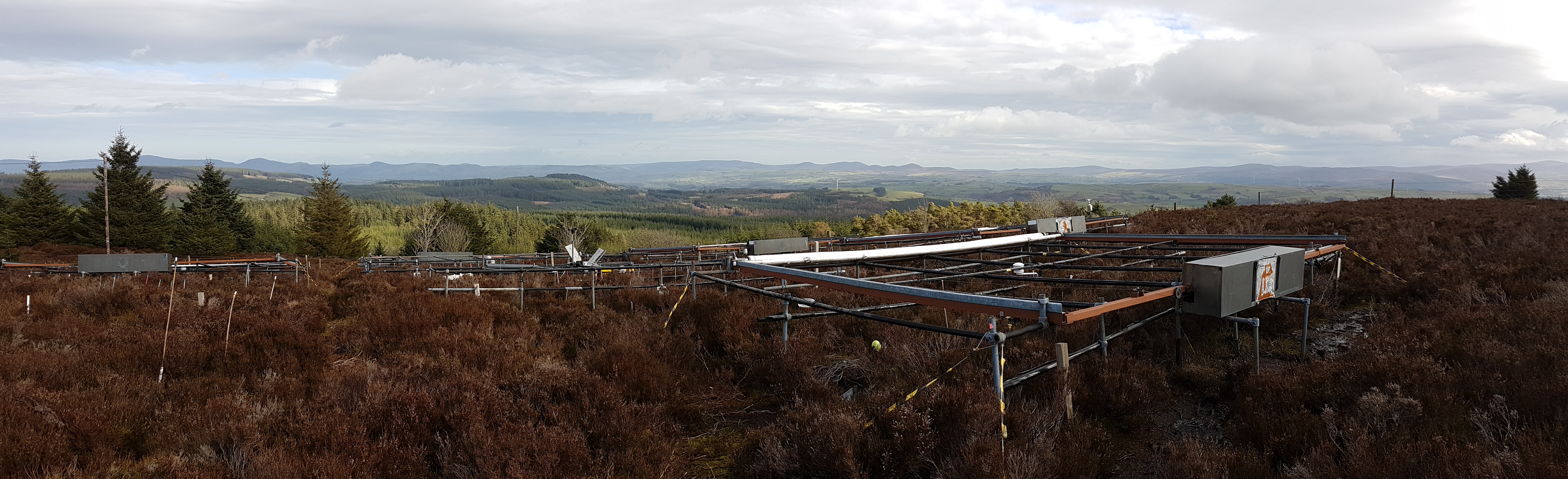
The site is located in Clocaenog Forest in North East Wales (53o 03’ 19’’N -03o 27’ 55’’ W). It is a typical upland west-atlantic moorland, dominated by the evergreen shrub Calluna vulgaris (heather). Heather makes up >60% of the plant biomass at the site, but Vaccinium myrtillus and Empetrum nigrum are also present.
-
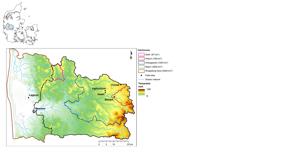
The HOBE experimental catchment is located in the western part of Denmark. The topography of the catchment is relatively flat. The surface elevations in the eastern part of the catchment are about 125 m above sea level at the Jutland ridge and gently decreasing to sea level elevations towards the coast. Alluvial outwash deposits in the form of sand and gravel dominate the central part of the catchment. Towards east, glacial deposits of moraine till are present with a higher content of clay. Also the remnants from the Saale glaciation have higher clay content and the dominant sediment type at these locations is clayey sand. Overall the top sediments are highly permeable with little water retention capability and the stream flow is therefore dominated by groundwater inflow. Based on a classification of the topsoil four soil classes can be identified in the catchment. The by far most dominating soil type is fine/coarse sandy soil. The Quaternary deposits have a thickness less than 50 m in the eastern and central part of the area increasing up to 250 m towards west. The Quaternary deposits are underlain by Miocene sediments in the form of alternating layers of marine, lacustrine and fluvial deposits forming layers of clay, silt, sand and gravel. Further below thick layers of Paleogene clay are found with little permeability and thus acting as a lower impermeable boundary for the aquifer systems. The sand and gravel layers from the Quaternary and Miocene periods form interconnected aquifer systems. The land surface of the catchment is predominantly agriculture and due to the sandy soil characteristics extensive irrigation of the agricultural crops takes place. Based on satellite data the land-use distribution is estimated as follows: grain and corn (55%), grass (30%), forest (7%), heath (5%), urban (2%) and other (1%). The climate of the observatory is of maritime origin and influenced by weather systems coming from the Atlantic Ocean. The weather conditions are variable with frequent precipitation. The prevailing winds from west lead to relatively mild winters and cool summers. The mean annual precipitation is about 1050 mm/year. It varies over the season with highest amounts in the months of October-December and lowest in the months of April-May. The mean annual temperature is 8.20C. The highest mean monthly temperature is in August (16.50C) and the lowest in January (1.40C). Precipitation in the form of snow is highly variable from year to year; in some years, no snowfall occurs and in others, it may stay on the ground for months.
-
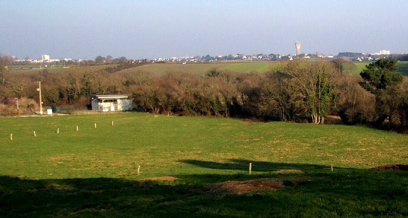
The Ploemeur-Guidel observatory (Britanny, France) is focusing on surface-depth relationships in a fractured crystalline geological context and oceanic climate. It is built on 2 sub-sites, one highly anthropized, the other in natural state. In Ploemeur, groundwater has been pumped since 1991, supplying more than 1 million m3 of clean drinking water annual at a sustainable rate. Such high productivity is explained the specific fractured network in granite and micaschists, draining deep geological layers (~400 m). Extracted water quality is very good, with limited nitrate concentration, in a region that has been strongly affected by widespread pollution. Guidel site is in a similar, but natural context. Deep iron-rich groundwater is upflowing, creating surface and deep groundwater-dependent ecosystems, and feeding a classified coastal wetland. Both sites have a very dense equipment to study rapid to long-term surface-depth exchanges: a flux tower, unsaturated zone monitoring, a network of ~50 shallow (<10m) and deep boreholes (>80m), hydrochemical, temperature and deformation. An well-characterized fractured experimental site offers the possibility to conduct experiments to test innovative instruments and develop new methodologies
-
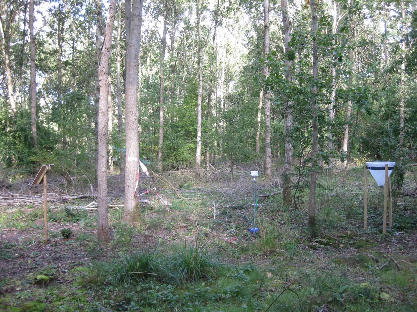
Vestskoven is a 15 km2 ongoing afforestation area located 15 km west of central Copenhagen. Since 1967 arable land has successively been bought up for afforestation in order to establish a large forest area for outdoor activities and wood production. In 1998, afforestation chronosequences in oak (Quercus robur) and Norway spruce (Picea abies) were established as a research platform to quantify soil carbon dynamics, water recharge, nitrogen budgets and ground vegetation species diversity. The soil and grund vegetation species composition were resampled in the chronosequences after 13 years in 2011. Since 2003, an ICP-Forests Level II/Core plot with integrated monitoring under the UN Convention on Long-Range Transboundary Air Pollution (CLRTAP) is placed in an oak stand. Monitoring has developed over time. There is no time limit on the monitoring financed by the Ministry of Environment and Food in Denmark.
-
Suserup Skov (19.2 ha) is an old growth temperate forest dominated by beech Fagus sylvatica, pedunculate oak Quercus robur, ash Fraxinus excelsior, wych elm Ulmus glabra, and black alder Alnus glutinosa, admixed with lime Tilia platyphyllos and sycamore maple Acer pseudoplatanus. KU/IGN-SNB, is a 19,2 ha old-growth beech-dominated mixed deciduous forests on western Zealand owned by Sorø Academy. The forest use dates back to 4200 BC. A conservation act was placed on the forest in 1925 for biological and recreational purposes but allowing a minimum odd felling until the act was updated in 1961 to a non-intervention forest. The forest is unique at European level in terms of nonintervention, and the long-term status as non-intervention forest has led to a unique steady state in biomass and accumulation of dead wood, thus serving as an important reference site for unmanaged temperate deciduous forest development. There are long-term data records of e.g. biomass, dead organic matter, soil, forest structure, flora and fungi starting from 1992. The platform is included in a series of paired managed and non-intervention forests for studies of forest structure, biodiversity and biogeochemistry in mature and old beech-dominated forests. Suserup Forest includes an ICP Forests level II plot (2001-). Upgrades: eLTER master sites: soil moisture content (TDR), remote sensing of growth and forest structure, LAI, NDVI (Lidar, camera), continuous plant phenology (web cam),and insect monitoring (optical sensors) as biodiversity measures, ambient air quality and air pollution.
-
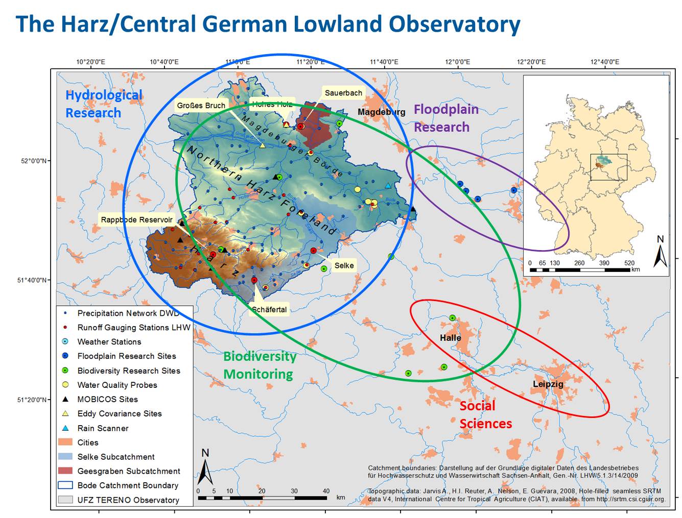
In the framework of TERENO "terrestrial observatories" are set up in selected German regions for climate and landuse change studies. The Harz/Central German Lowland Observatory is one of these observatories that are equipped with a combination of in situ measuring instruments and ground-based, airborne and satellite-borne remote sensing techniques. Additionally a network of biodiversity observation plots is installed. Within the Harz/Central German Lowland observatory the climate feedback experiment SoilCan using a lysimeter network will be realized. Soil monoliths with different vegetation are transplanted along the existing natural gradient in temperature and precipitation within the four TERENO observatories. Within the Harz/Central German Lowland observatory three main intensive test sites have been selected: Sauerbach, 27 ha, forest/agriculture, Schäferbach, 27 ha, agriculture, Selke Catchment, forest/agriculture. Instrumentation and surveys enable: Dense Soil Moisture Monitoring, Groundwater Monitoring, Runoff and Solute Monitoring, Eddy covariance tower (CO2, NO2, CH4, available end 2011), Geophysical Monitoring (ERT, GPR, EM), Airborne Monitoring using Hyperspectrum Imagery (flight campaigns), Soil Respiration Monitoring (available end 2011), Climate station, Deposition station (available end 2011), Biodiversity Assessment, DTS-observation of groundwater-surface water interactions (Distributed Temperature Sensing, using fiberoptics and temperaturprobes), Vadose Zone Monitoring System (in-situ soil water budget observation), Rainscanner (small weather radar, available end 2011). At the GCEF in Bad Lauchstädt opportunities will be given to manipulate climate change and land environment, from which visiting scientists may benefit. This infrastructure is available since 2013. The monitoring, observation, and research activities within the Harz/Central German Lowland Observatory are organized in four main platforms: 1. Hydrological Platform: catchment of the river Bode (shape on the map) 2. Biodiversity Platform (green dots on the map) 3. Floodplain Platform (pink dots on the map) 4. Urban Platform: the city of Leipzig as focus area