
precipitation intensity
Type of resources
Available actions
Topics
Keywords
Contact for the resource
Provided by
Years
Formats
Representation types
-
Hochjochferner (glacier) is located between the Schnalstal and the Venter valley. It extends over an area of 612 ha from the Grawandspitze (3.251 m) and the Fineilspitze (3.514 m) to the Hochjoch (2.750 m) and into the Rofen valley. The western part of the glacier was used as year-round ski area until 2012.
-
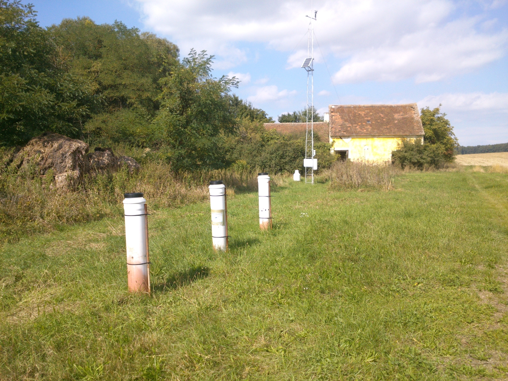
Hintereisferner (glacier) is located at the end of Rofen valley between 2500 and 3750 m altitude. The glacier is situated in Naturpark Ötztal, and one of the glaciers with longest records of glacier mass balance worldwide. In addition to that, a number of hydrological and meteorological observations complete the data base. Currently, 3 weather stations and 6 rain gauges provide data. Topographic and land cover data are available, in the recent years on an annual base. The area is used for Alpine tourism (but without a hut in the basin), for limited hunting and growing a few sheeps.
-
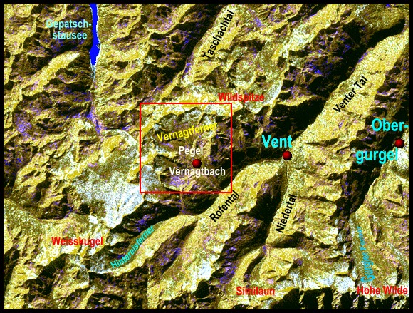
The Vernagtferner region has a long tradition of glaciological research performed by groups from Munich. It started in 1889, when Prof. Sebastian Finsterwalder from the Technical University in Munich produced the first map of a complete glacier based on terrestrial photogrammetry. Since then, numerous maps of the glacier have been made, describing the change in surface elevation for more than a century. These maps form the basis of the geodetic method of glacier mass balance determination, which provides volume changes as average data for the period between two surveys, i.e. typically for 10 years. Since the start of the glaciological method on Vernagtferner in 1964, annual as well as winter and summer mass balance data are available continuously. But only since 1973, the construction of the Vernagtbach station, approximately 1 km below the glacier margin at that time, provided the means to record a larger number of hydrological and meteorological parameters with a temporal resolution of typically 1 hour. For more information see Braun, L. & Escher-Vetter, H. (2012): Gletscherforschung am Vernagtferner. Themenband zum fünfzigjährigen Gründungsjubiläum der Kommission für Glaziologie der Bayerischen Akademie der Wissenschaften, München. In: Kuhn, M.: Zeitschrift für Gletscherkunde und Glzialgeologie. Band 45/46 (2011/2012).
-
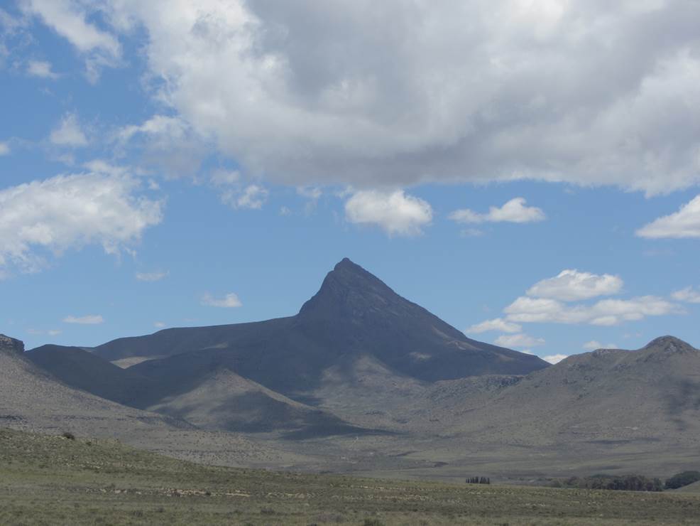
Compassberg, the highest peak in the Sneeuberg range, resembles a compass needle towering 2 502 metres high. The mountain harbours a diversity of species, including endemics such as the Compassberg Skolly (Thestor compassbergae) butterfly, found only the slopes of this mountain. Compassberg is located near the village of Nieu Bethesda, 55 km north of the town Graaff-Reinet in the Eastern Cape Province.
-
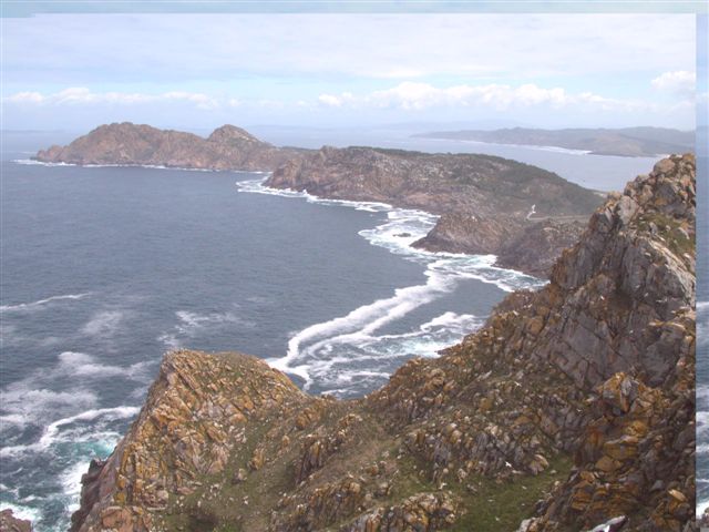
The Atlantic Islands of Galicia were declared a national park in 2002 in order to protect one of the best examples of Atlantic Ocean-associated ecosystems. Although on land there are highly valuable and exceptional ecosystems relating to cliffs, dunes and scrub, it is the marine setting that hosts the greatest biodiversity. Situated off the Rías Baixas (Lower Estuaries), the archipelagos Cíes, Ons, Sálvora and Cortegada, create a natural barrier to the ocean, thereby accentuating the rías’ estuary influence. The terrain features dune systems, cliffs with gorse and heather scrub, while the marine environment hosts a rocky seabed with large communities of brown algae (Sacorhiza polyschides and Laminaria spp.), which are home to a great variety of living things. The marine currents deposit sand in the most sheltered parts, and together with the important Mäerl beds consisting of the remains of calcareous algae, create a shifting substrate to which living things must adapt.
-
None
-
The site Unterpullendorf is part of the European Level II Forest Monitoring System in the frame of the International Co-operative Programme on Assessment and Monitoring of Air Pollution Effects on Forests (ICP Forests). This site is one out of 16 Austrian Level II sites; it was established in 1995 and is, since 2006, part of the LTER Austria network. The site is situated about 80 km south of Vienna near the Hungarian border at 290 m a.s.l., in a homogenous about 100 years old managed oak stand.
-
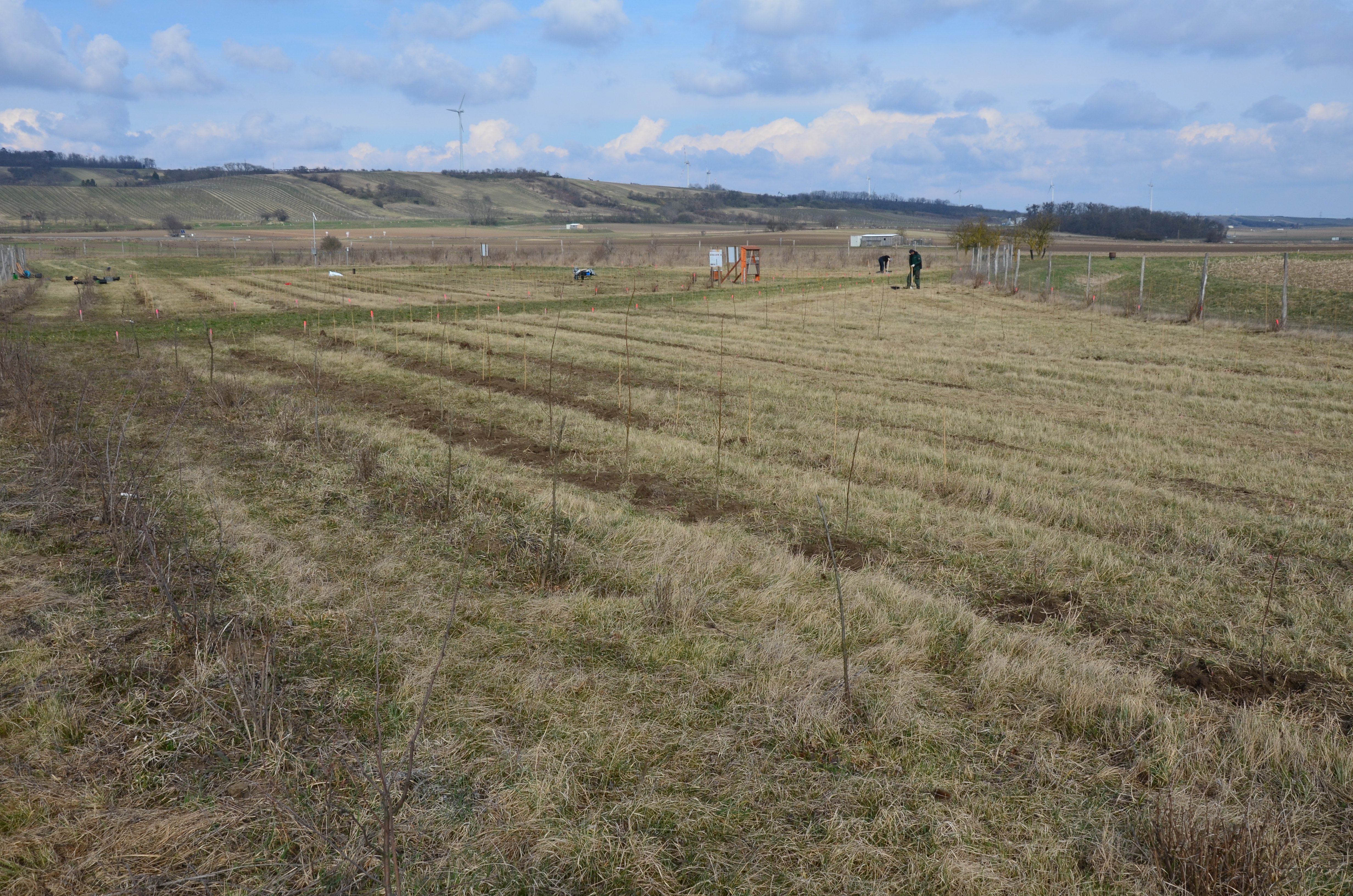
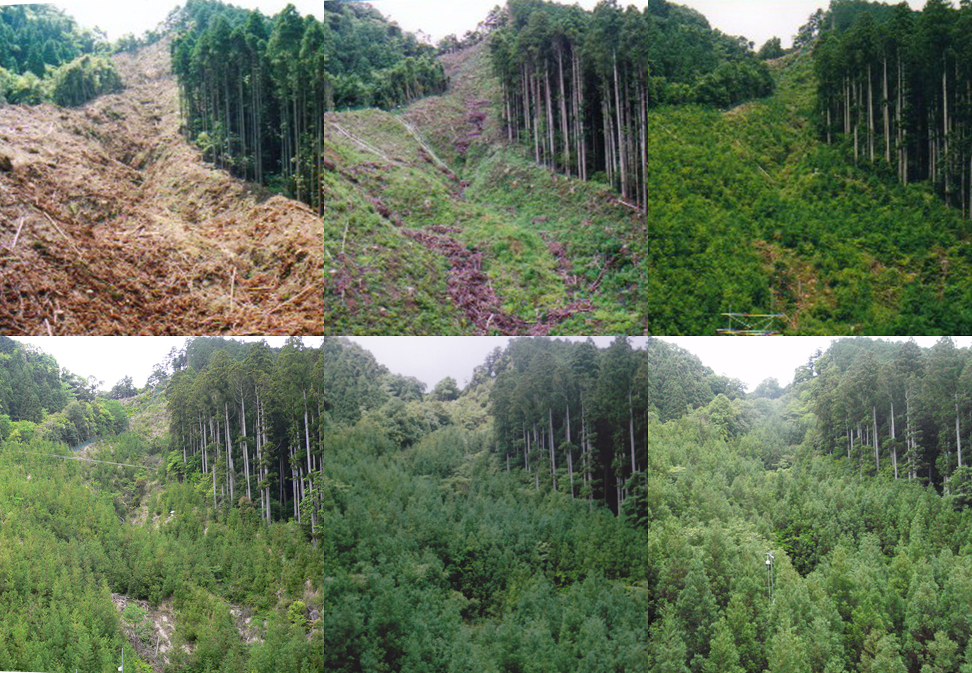
This site is part of the BFW project "Klimaforschungswald". The aim of this research project is to evaluate which tree species will fullfil the important tasks and functions of the forest ecosystem in the future. Furthermore, temperature and precipitation fluctuations in particular are to be documented in order to be able to map a possible trend and the influence of the growing vegetation. In addition to the site characteristics, attention was paid to whether they were particularly attractive for bees and insects, which should increase their food supply.. When selecting the trees and shrubs, in addition to the site characteristics, attention was paid to whether they were particularly attractive for bees and insects. This should increase the food supply for bees and insects. Furthermore, information boards were erected and meteorological measuring stations installed. The meterological measuring stations record air temperature and relative humidity as well as precipitation.
-
Deposition data from LTER Zöbelboden. The data comprises monthly wet only and bulk precipitation chemistry from an open area and canopy throughfall chemistry from 2-3 forest plots
-
It contains monthly weather data. The information has been obtained from meteorological stations located in Sierra Nevada and surroundings