
rainfall variability
Type of resources
Available actions
Topics
Keywords
Contact for the resource
Provided by
Years
Formats
Representation types
-
This site falls partly with the isimagaliso wetland park as well as within forestry areas on its boundary. SAEON is beuiling onf a >40 year ground water record and has added rain gauges to the site. It is a cimplimentory site to teh SAEON MCP site assessing the realtive impacts of land use land cover and climate on the ecosystem services in the area. Threats to Lake St Lucia Ramsar Site from proposed open cast mining operations in 1992 (CES, 1992) prompted a national and international outcry culminating in an international petition to “Save St Lucia” that led to its declaration as a World Heritage Site. This culminated in the proclamation and development of the iSimangaliso Wetland Park that protects the marine and coastal environments from Cape St Lucia to the Mozambique Border. The conservation policy in terms of the 1992 Conservation Development Plan was to protect a diversity of habitats such as coastal dune forests, coastal grasslands, hygrophilous grassland, coastal woodlands and shrublands. This vegetation mix would allow for the required habitat and feeding area for priority St Lucia animal species ...” (CES, 1992). Consequently, the St Lucia system, with its rich diversity of habitats, will be protected by national and international legislation for long-term global prosperity.
-
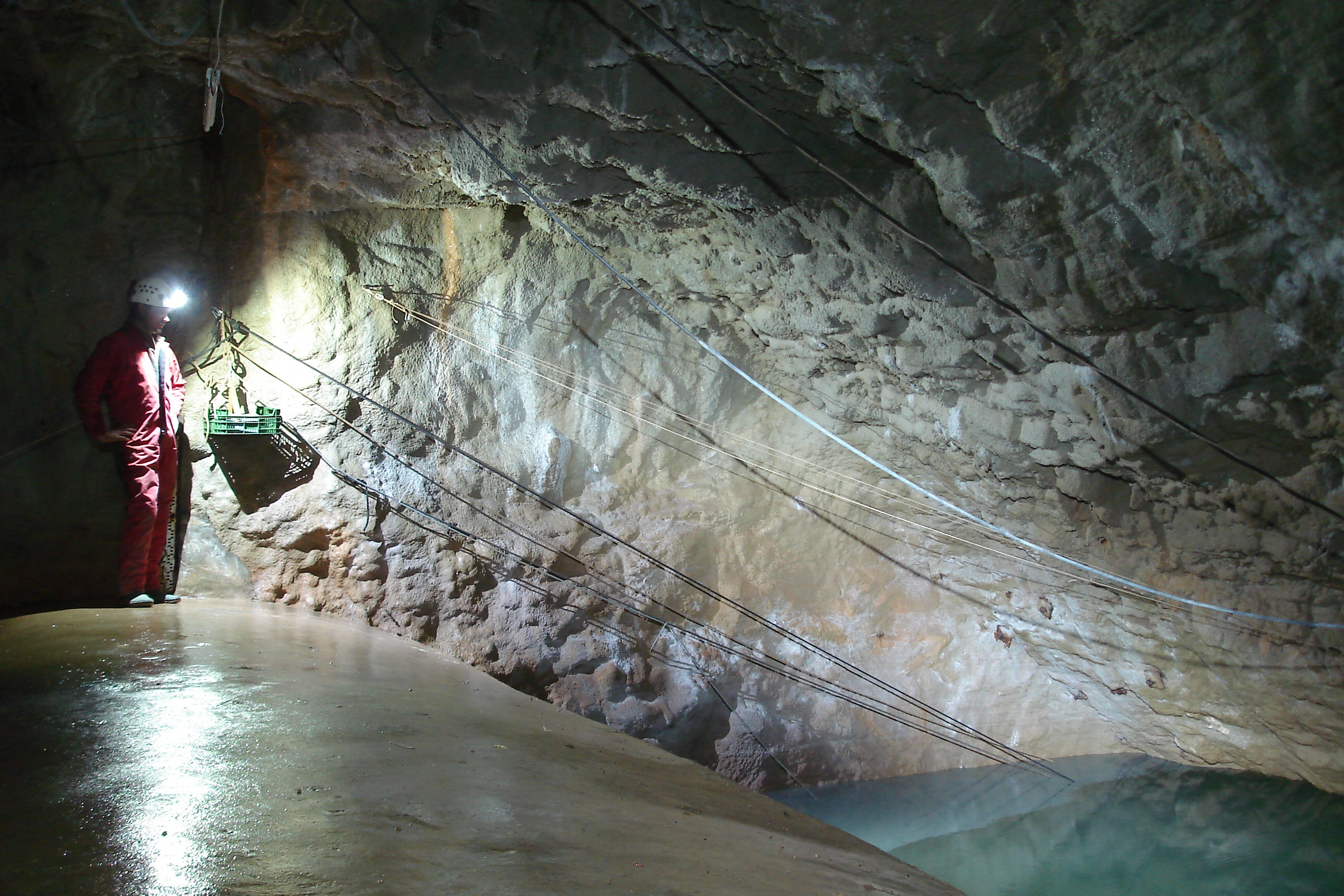
The Mediterranean and coastal site of Port-Miou is a wide regional carbonate aquifer, with a catchment area around 400 km², in south of France (Provence, France). It extends mainly over natural land, in the vicinity of one of the main city of France (Marseille), facing recent urban expansion and future groundwater resources management issues. Top of the recharge area culminates at 1100 m asl, and the main outlets are submarine springs. Karst features are observed in surface (polje, intermittent rivers, sinkholes, karren, caves) and underground. Many karst networks have been explored in the unsaturated zone of the aquifer, but also in the saturated zone below the sea level. Karst features and conduits drive the groundwater flows to the main outlets. The Port-Miou submarine springs outflow from huge flooded karst conduits, explored by cave diving over several kilometers inland, and to -235 m deep. Groundwater is brackish, polluted by seawater intrusion. The Port-Miou observation site includes flow rate, salinity and temperature monitoring at the main brackish spring, in an in-situ underground laboratory located 500 m inland from the seashore, directly in the main karst conduit. Rainfall is also recording in the catchment area, and rain water samples are collected for water isotopes observation.
-
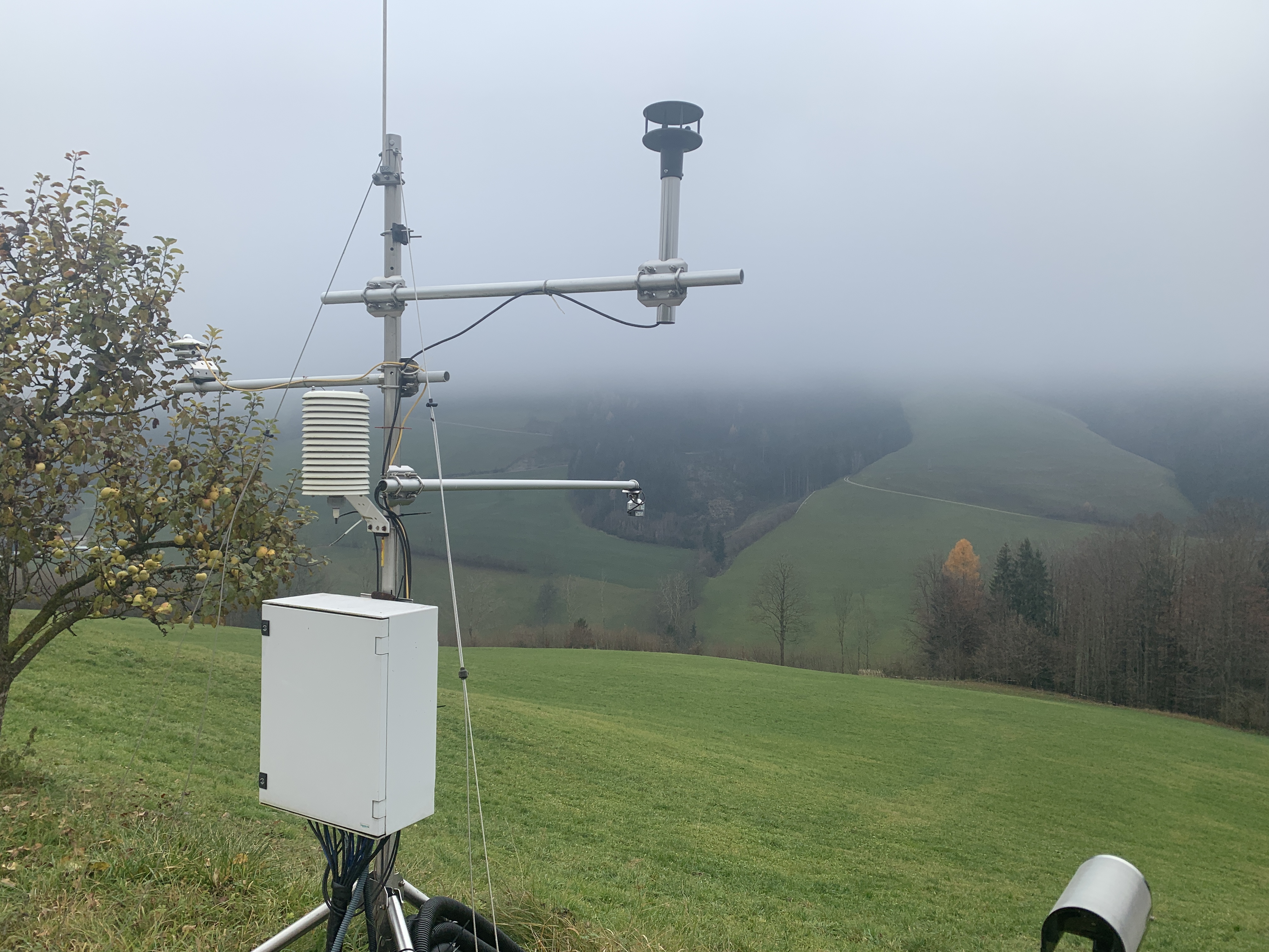
The LTER site is a COMPLEX site, with observation sites focusing (a) on the three glaciers in the Kaunertal Valley, (b) 10 ecological and erosion sites along a succession gradient in the pro glacial, and (c) one climate station. The station (a) is run by Andrea Fischer (AAS), stations (b) and (c) within the PHUSICOS project coordinated by Sabine Kraushaar (University of Vienna). In the proglacial area of the Gepatschferner glacier ten mechanical erosion sites with each three plots (each 2x3m, see picture) are installed monitoring biotic and abiotic interrelations in 5 different succession classes. Small scale erosion processes such as splash, rill and interill erosion processes are quantified as a function of the present species composition. A climate station on 2350m run by solar power complement the set up.
-
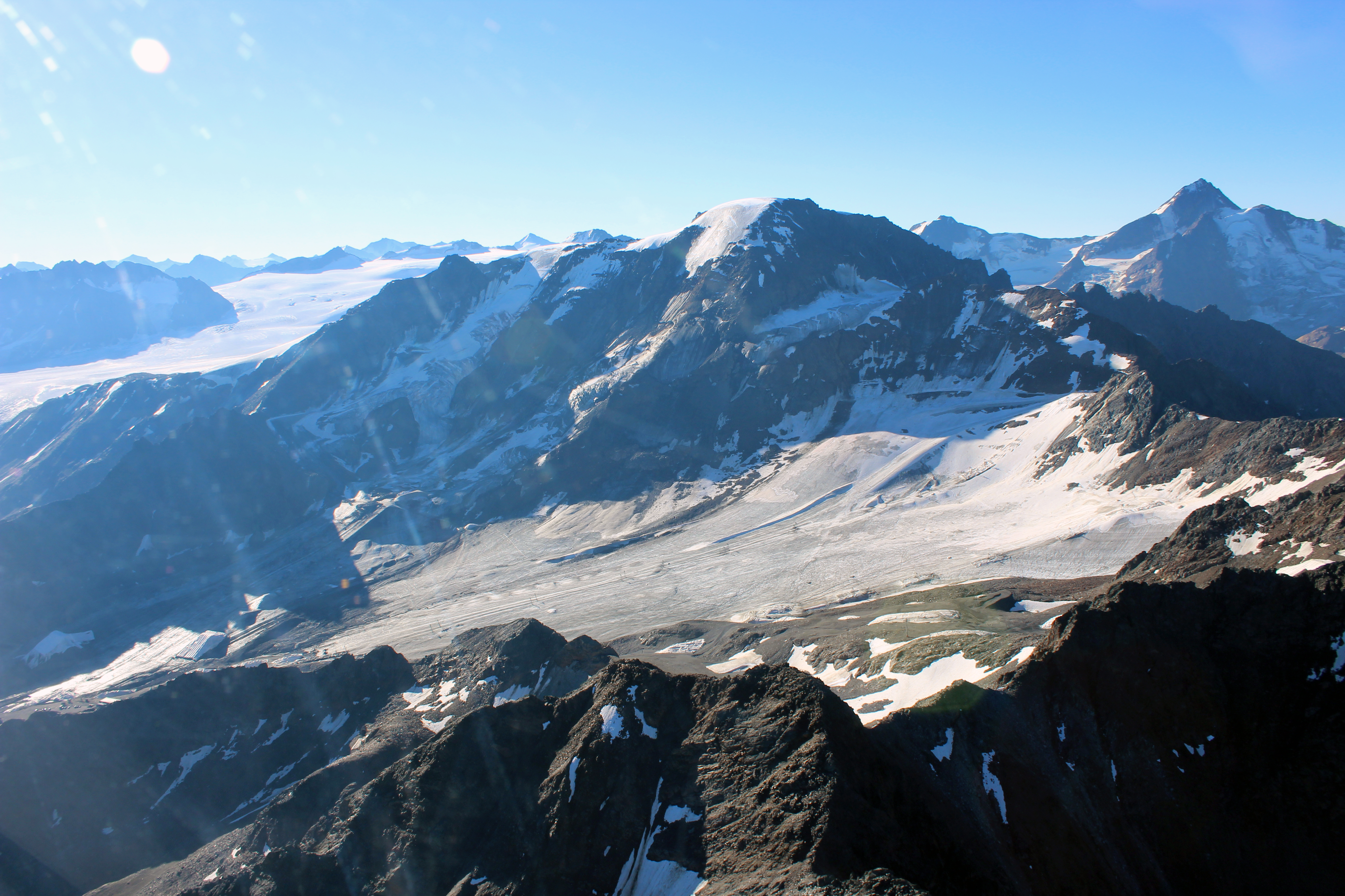
The LTER site Kaunertal reaches from the glaciated peak of the Weißseespitze (3600 m) to the Gepatschferner, the second-biggest Austrian glacier, down to the community of Kaunertal. The Gepatschferner is one of the most thoroughly studied glaciers in Austria, with a chronology of advances and retreats that covers the Holocene. Comprehensive data also exist on changes in the tree line and the distribution of permafrost and rock glaciers. Run-off and mass balance data on the glacier and detailed studies on the geomorphology of the glacier forefield and the role of biota for sediment mobilization complement the studies in the glaciated catchment area. In 2023 we started a project on butterfly monitoring. In 2021 the community of Kaunertal created a museum dedicated to research.
-
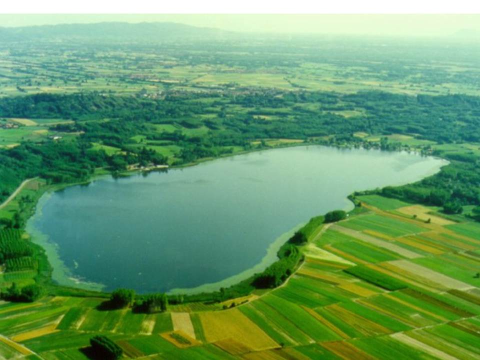
Lake Candia is a small and shallow lake, located in North-Westerm Italy. The mean elevation is 226 m a.s.l., the surface is 1,5 km², the max depth 7,7 m, the mean depth 4,7 m and the volume 0,007 km3. Lake Candia has suffered during its evolution a natural increase of its trophic state, undergoing a process of eutrophication culminated with a marked worsening of his ecological quality since the '60s. In the late '70s and mid '80s, this ecosystem was affected by fish mortality episodes and by the enormous development of emerged and submerged aquatic macrophytes. The systematic scientific study of Lake Candia began in 1985, when the CNR of Verbania was asked to perform a limnological research with the aim to propose a possible restoration intervention. In addition to the control of pollution sources from the basin, environmentally sound technologies were applied to reduce the effects of eutrophication, such as biomanipulation of the aquatic food chain and macrophyte control and management.The experiment conducted in Lake Candia has shown that significant improvements can be achieved through the management of a specific key components of the biocenosis of the lake. Data collection activities on hydrochemistry, phytoplankton, zooplankton, fish fauna, macrophytes, as well as physical limnology, took place from 1986 until 2012. To date, only hydrometeorological data collection (precipitation, air temperature, wind, solar radiation and lake levels), started in 1987, is active. LTER specific topics are: Long-term analysis of changes in community functional diversity of phyto-and zooplankton. Evaluation of the lake ecosystem response to short and intense rainfall events, in relation to the increase of nutrients input through runoff.
-
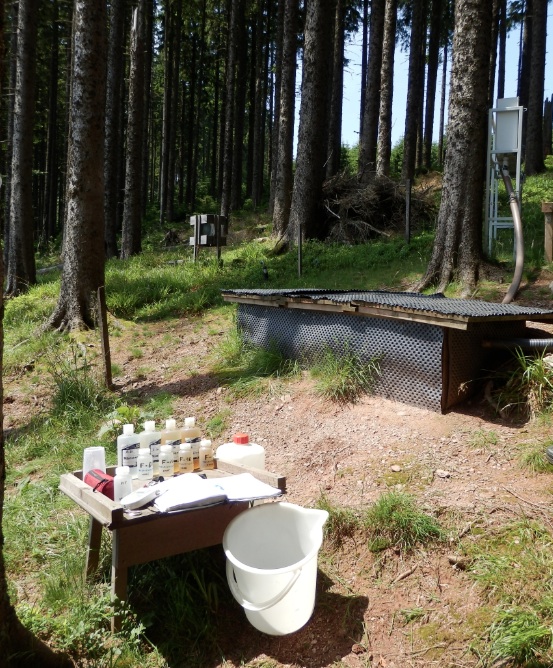
The Strengbach Watershed is a granitic watershed (80ha) located in NE of France, in the Vosges Mountains at altitudes between 880 and 1150 m (omsl) and with highly incised side slopes (mean 15°). This catchment is situated in a remote area lacking human activities except forest management. The forest covers 90% of the area and corresponds about to 80% spruce (mainly Piceas Abies L.) and 20% beech (Fagus Sylvatica). The climate is temperate oceanic mountainous. The site is manage by Ecole et Observatoire des Sciences de la Terres (University of Strasbourg / CNRS-INSU-France).
-
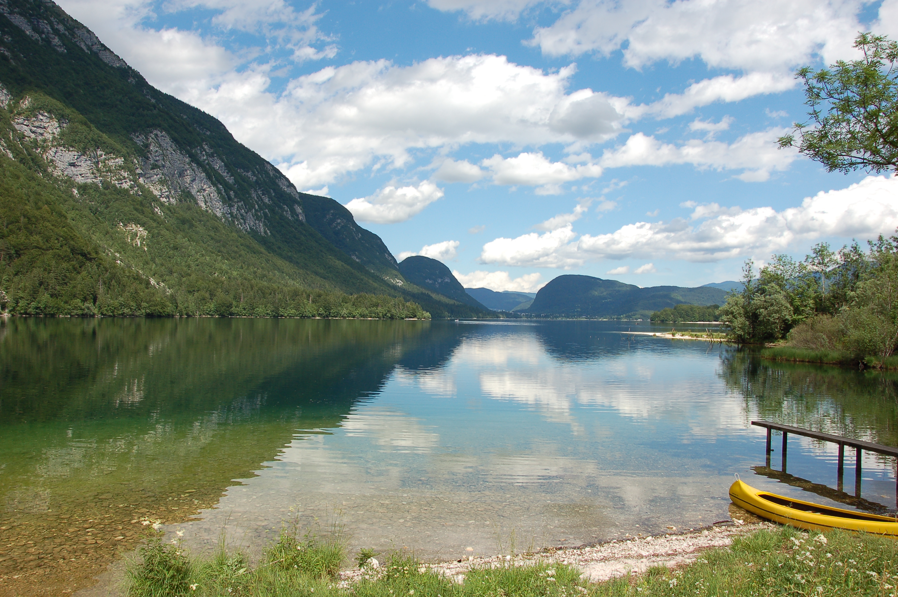
Lake Bohinj is of tectonic-glacial origin and was transformed by the Bohinj glacier. Its surface area is 3.28 km 2 , its volumeWeather conditions and chlorophyll concentrations determine long-term macrophyte community dynamics of Lake...92.5 × 10 6 m 3 and its maximum depth 45 m. It is located at an altitude of 525 m a.s.l. and issurrounded by mountains that are up to 2000 m high. Lake Bohinj is conditioned by the main inflow from River Savica and by several karst springs from the base of Mount Komarča and has a single outflow, River Sava Bohinjka. The residence time of the water in Lake Bohinj is about 4 months, which means that the total volume of the water in Lake Bohinj changes three times a year. The surrounding watershed comprises around 94.3 km2 and is mostly uninhabited, with a large portion extending above the tree line; therefore, the input of nutrients into Lake Bohinj is moderate. This watershed receives about 3300 mm of rainfall a year. Long-term temper-atures show a tendency to a rise. In winter, usually in January, the surface water cools and the lake can be frozen over. From 1961 to 1990, Lake Bohinj was frozen over for a mean of > 50 days/year, while in the decade from 1991 to 2000, the mean number of days with ice cover was reduced to 31 days/year. Since 1990, the lake did not freeze completely in individual years. The majority of the lake catchment area consists of carbon-ate rock, and therefore, the main lake sediment fraction is carbonate, while quartz and feldspar represent a minor part.
-
Landslides (translational and rotational slides, debris flows, rock avalanches, rock falls, etc.) rank among the most common natural hazards in Lower Austria. As these processes often inherit sporadic phases of activity, it is essential to generate specific long-term measurement series, enabling the analysis of surface and sub-surface dynamics in connection with potential triggering factors. Therefore, in 2014 the project “NoeSLIDE – Monitoring diverse types of landslides in Lower Austria” was initiated. Three subsites are summarized under the parent site "LTER NoeSLIDE".where various types of landslide processes, Hofermühle (complex earth slide - earth flow), Gresten (Salcher landslide) and Brandstatt are monitored with "classic" as well as novel approaches. This includes surface and subsurface monitoring systems. The main research aims comprise implementation of long-term monitoring systems (10+ years) for continuous observation of gravitational mass movements, testing of novel and innovative methods on multiple locations and data availability in a WebGIS application for simple online analyses for authorized users.
-
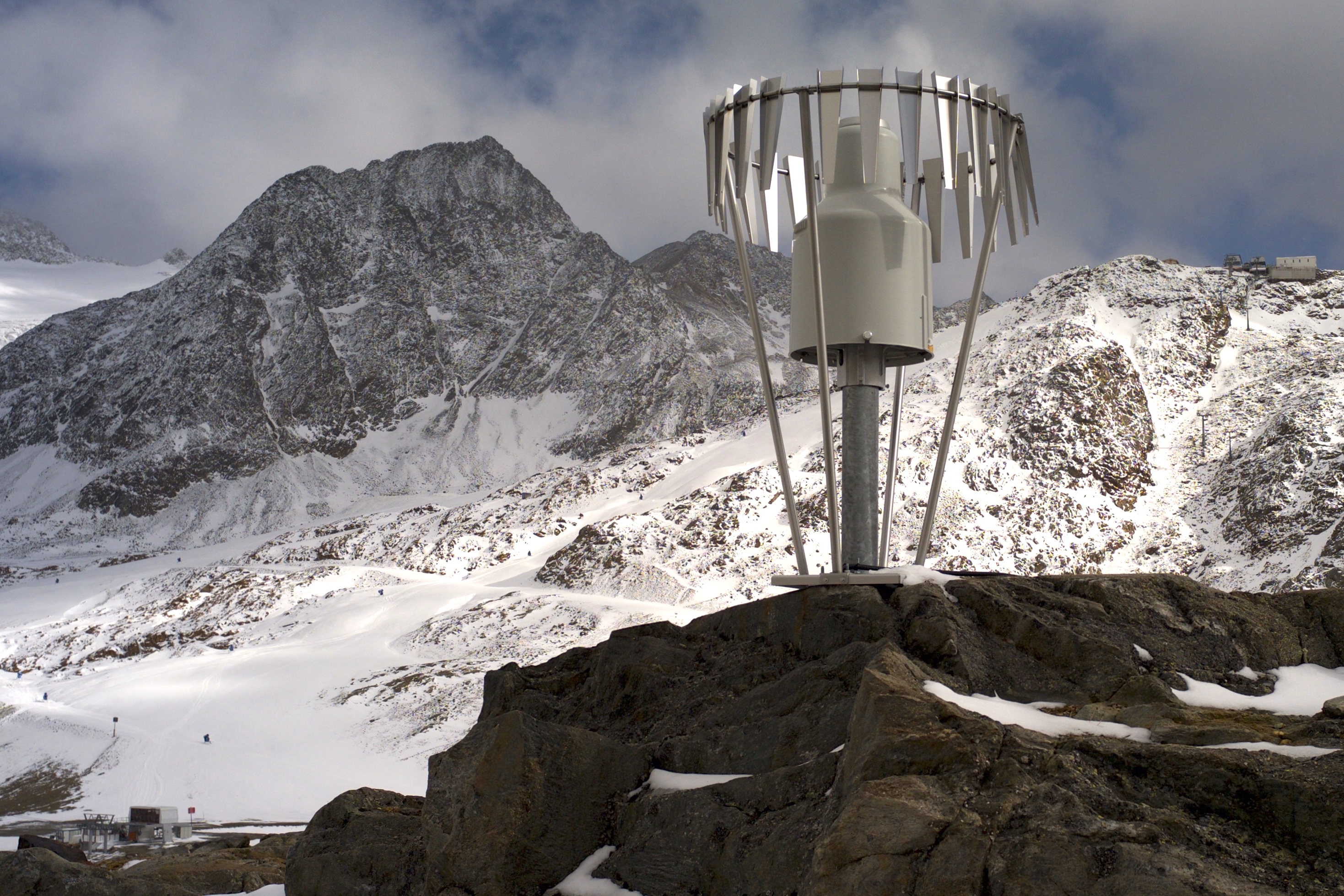
In the Rofental (Ötztal Alps) a consortium of the three institutions, and open to research partners worldwide, concentrates on studying and monitoring cryospheric, atmospheric and hydrological processes and changes with particular attention to the complex topography and climate settings of the Alpine terrain. First documents from glaciers in the Rofental, Ötztal Alps, date back as far as 1601 and regular observations and systematic studies had begun more than 150 years ago. First geodetic maps where generated in the late 19th century, first rain gauges were mounted in 1929 and glacier mass balance time series of Hintereis-, Vernagt- and Kesselwandferner are among the longest uninterrupted world-wide, building a basis for regional hydrological studies, for glacier-climate and ice dynamic research, and for estimating the world wide glacier’s contribution to sea level rise. By 2014, networks of stakes and pits for mass balance monitoring are maintained at Hochjoch-, Hintereis-, Kesselwand- and Vernagtferner by the consortium members. Runoff gauges at Vernagtferner and in Vent (operated by the Hydrological Office of Tyrol) and a network of rain gauges in the Rofental basin are the basis for high mountain hydrological studies. A varying number of automatic weather stations on and in the surroundings of the glaciers are operated by the Rofental consortium. The glaciers in the Rofental are frequently used as a test site for process studies, model development and evaluations and for new remote sensing or ground based methods in glaciological research. A series of airborne LIDAR derived high resolution DTMs of Hintereisferner and its surroundings are available since 2001. They are subject of ongoing evaluations and method comparison studies as well as for monitoring and studying periglacial morphodynamics. The generated data are available from the consortium partners, glaciological key results are annually reported to the World Glacier Monitoring Service (WGMS). A research station on Hintereisferner (with observer status in the Horizon 2020 INTERACT network) and one at Vernagtbach serve as logistic bases for fieldwork. In recent studies, socio-ecological research aspects – e.g. in relation with the use of water for energy production and tourism – comprise the natural scientific investigations.
-
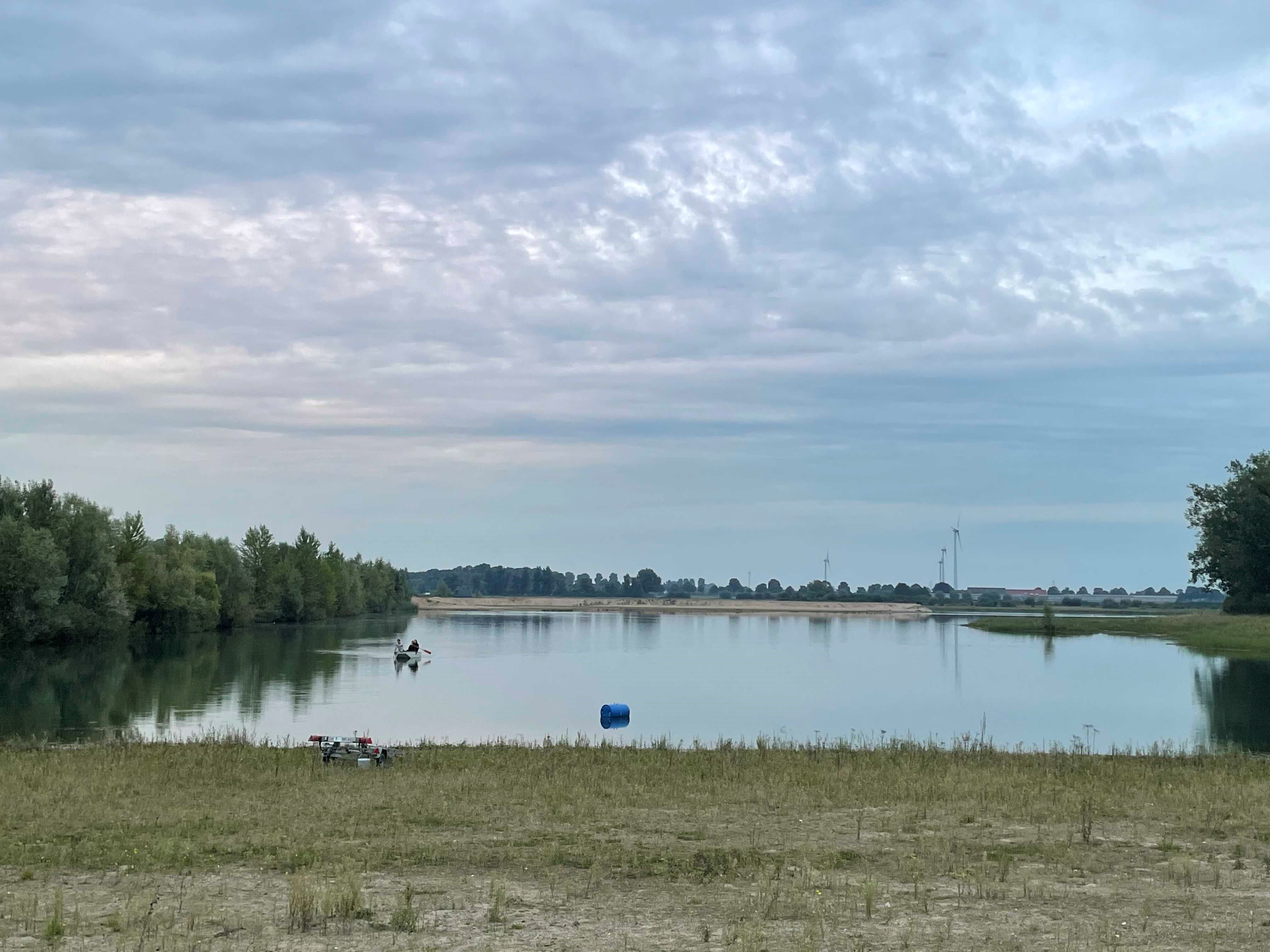
How do freshwater ecosystems react to changing environmental conditions and to what extent can these changes be captured in the dynamics of eco-evolutionary processes? The project REES ('Rhine Eco-Evolutionary System') aims at the long-term assessment of eco-evolutionary interactions in the Rhine as a limnic habitat under consideration of diverse associated water bodies. The study area includes the main flow channel of the Rhine (km 845, North Rhine-Westphalia), as well as Rhine oxbows, Rhine water-fed gravel pit lakes in ecological succession and the surrounding floodplain (Rees, district of Kleve). The Ecological Research Station Rees-Grietherbusch of the Institute of Zoology (University of Cologne) and the Nature Conservation Center District Kleve e.V. form the central infrastructure of the study area. In addition, the Ecological Rhine Station of the University under the direction of Prof. Dr. Arndt is also associated to the project, which enables direct sampling and experimental recording of the main Rhine flow channel. The extensive system of standing and flowing freshwater bodies covered in the REES study site allows the investigation of dynamic variations in biodiversity composition at all levels, from species diversity of communities to genomic diversity at the molecular level of individuals and populations. Along a selected trophic cascade, representative species will be long-term observed and analyzed ecologically and especially also (population-)genomically. The incorporation of ecological genomics is the core aspect of this LTER-D project, which is intended to capture the feedback of evolutionary changes on the ecological system. Population genomic approaches can be used to infer both evolutionary and ecological processes from genomic data. To cope with the dimension of this project, REES is designed as an interdisciplinary collaboration project and currently counts seven project partners with corresponding subordinate projects.