
remote sensing parameter
Type of resources
Available actions
Topics
Keywords
Contact for the resource
Provided by
Years
Formats
Representation types
-
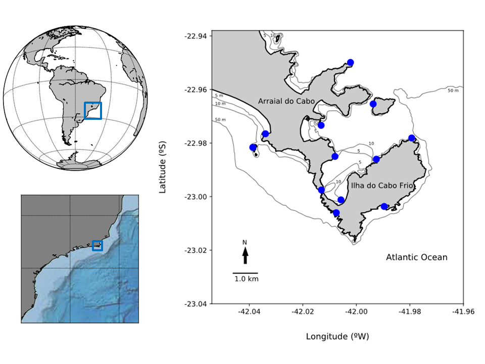
The site is located at 23ºS and 42ºW, in the city of Arraial do Cabo, Rio de Janeiro state. The area is influenced by the upwelling of SACW (South Atlantic Central Water), from approximately 300 meters depth, with temperatures ranging from 13 to 18 ° C. The occurrence of this phenomenon is due to topographical features, meteorological and hydrological, unique in this region. This upwelling has attracted attention because of the great fishing productivity, motivating many studies on this issue, especially on the oceanographic processes involved. This has led to the creation of the second Marine Extractive Reserve of Brazil, the RESEX-Mar Arraial do Cabo. The results coming from LTER RECA contributes to the consolidation of Extractive Reserve, through the provision of scientific information generated in different studies.
-
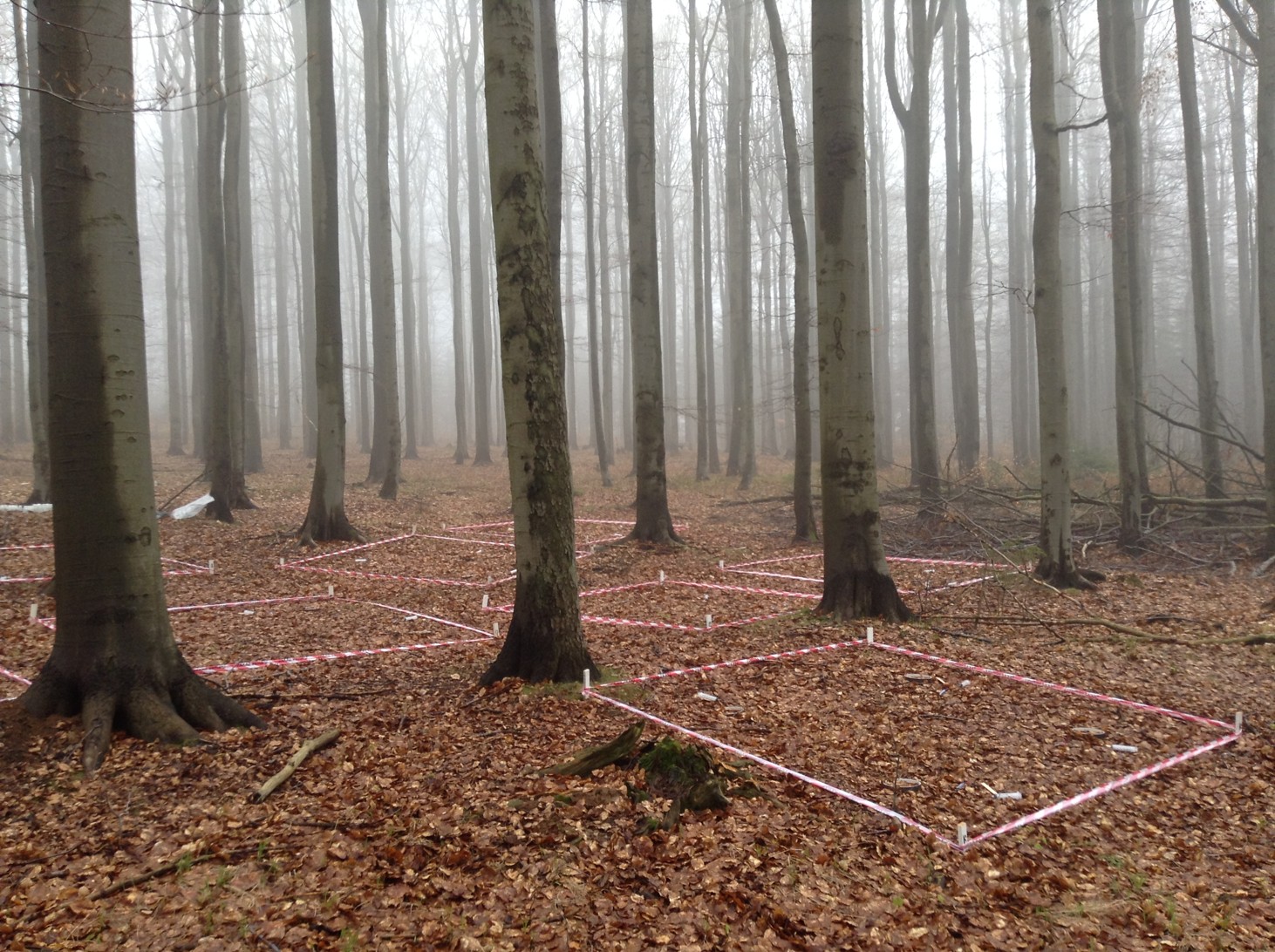
The spruce and beech stands under study are located in the Czech Republic in the Ore Mountains near the German border, close to the village of Načetín (50_35026” N, 13_15014” E). Both of the stands lie close to each other (ca. 700 m), so they are exposed to the same geological and climatic conditions. The average annual temperature is 7.1 _C and average annual precipitation is 1110 mm (2005–2017). Paragneiss underlies both stands, which are sloped to the north-west. The dominant soil type is dystric cambisol. The spruce stand lies at an elevation of 784ma.s.l. and it is covered by 80 years old monoculture of Norway spruce (Picea abies). The beech stand is situated at an elevation of 823 m a.s.l. and it is composed predominantly of European beech trees (Fagus sylvatica) that are approximately 140 years old.
-
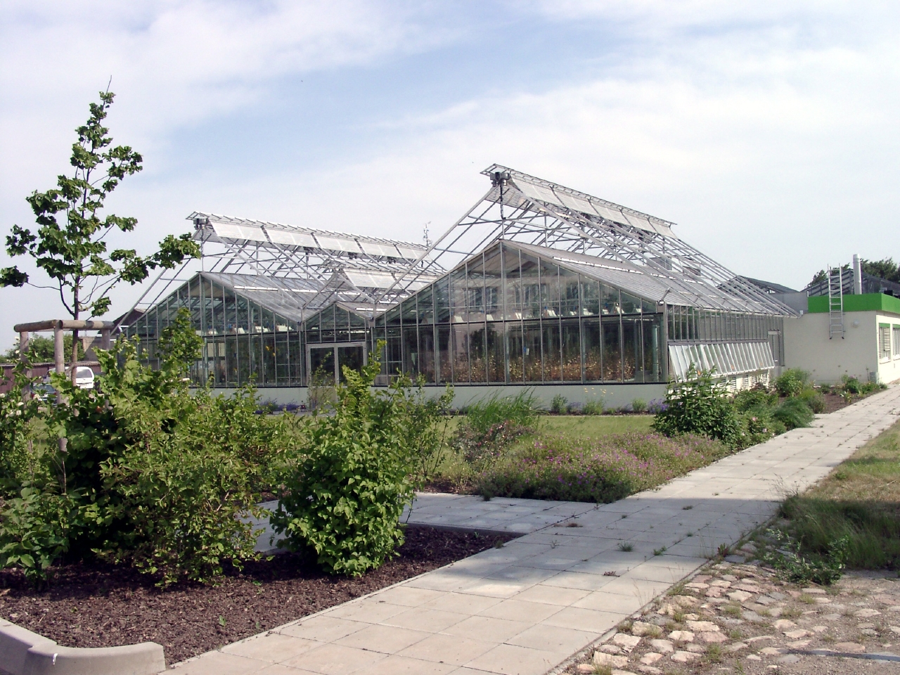
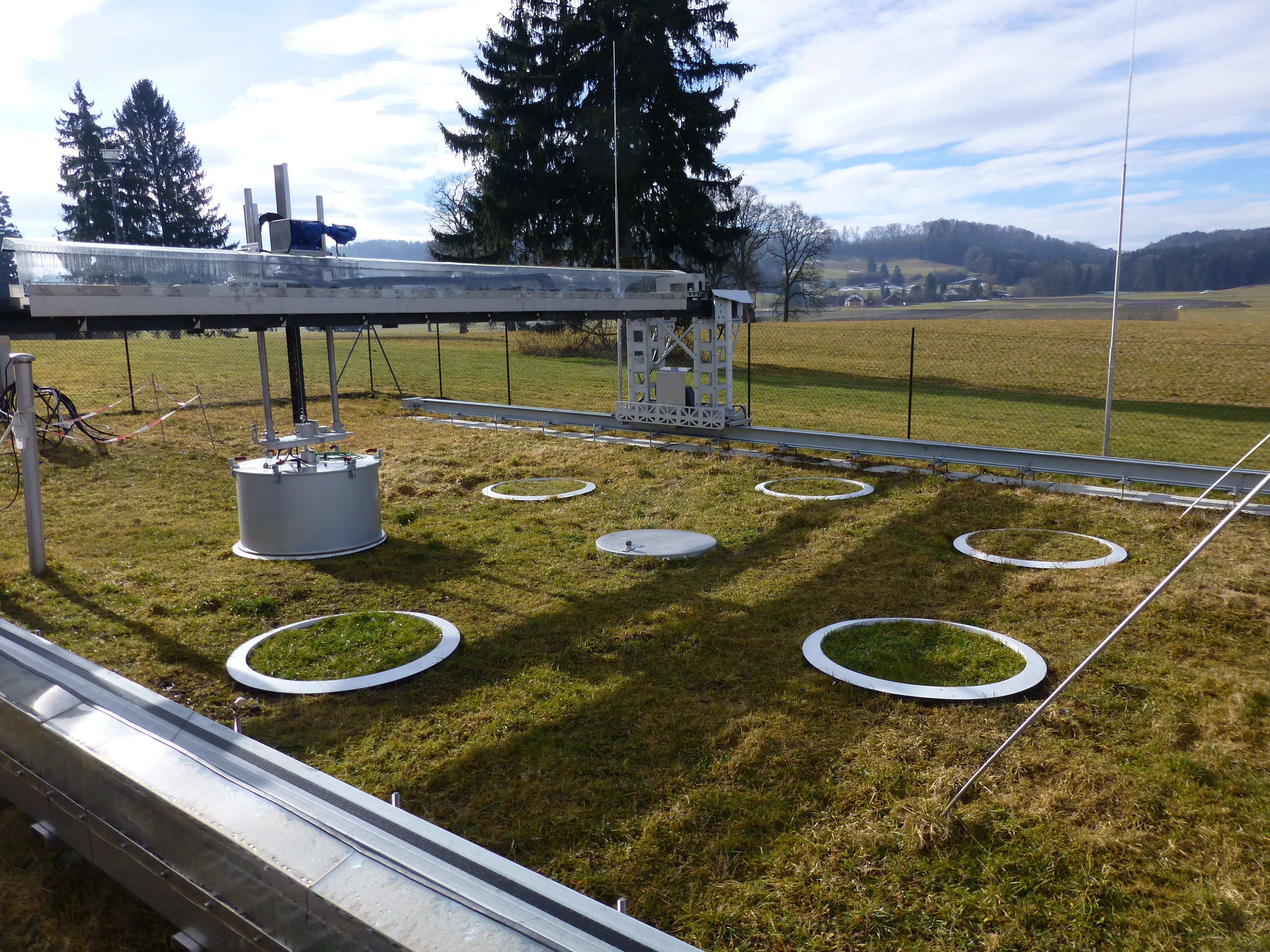
The Experimental Research Station in Bad Lauchstädt allows scale-dependent experimental investigations of different ecological systems in climatic chambers, heated and unheated greenhouses as well as in field sites on an area of 40 ha. The experiments contribute to a better understanding of the complex relationships in the soil-plant-atmosphere system. In particular, factors arising from the changes in land use, climate and species pool system are investigated. Thus, the experimental station Bad Lauchstädt is the experimental basis for numerous departments of the UFZ.
-
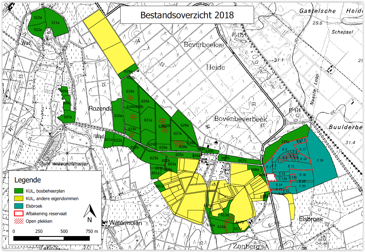
Beverbeek is a complex site consisting of areas with a primary conservation purpose as the two gazetted nature reserves Elsbroek (mesotrophic and oligotrophic mire with alder-birch woodland, Myrica bush) and Zooren (alluvial plain forest). Other parts are multifunctional forests with scots pine, corsican black pine, oak, larch, douglas fir, etc.
-
The LTER site was established in 2017 in a conservation area, known in English as the State Park of Campos do Jordão, which occupies an area over 8,000 ha in the montane belt of the Atlantic Forest in the Mantiqueira Range in south-eastern Brazil. The Park has been a conservation area since 1941, maintained by the State of São Paulo. The LTER is operating an integrated research programme, conceived in the vein of what Collins et al. (2011) have proposed as a "conceptual framework for long-term social-ecological research", aligned with the main objectives of US LTER programme (Patterns and control of primary production [biogeochemistry]; Spatial and temporal distribution of selected populations [Araucaria angustifolia and its biotic interactions with its soil symbionts, dispersers and frugivores] for representing trophic structure; Patterns and control of organic matter accumulation in surface layers and sediments [topo-hydro-pedo gradients]; Patterns of inorganic nutrient inputs [monitoring of dry deposition of N and other elements] and their movement through the soil [suction cups], subterranean and surface waters; Patterns and frequency of disturbance [climate; fire; past land use; illegal hunting; introduction of exotic wildlife]; Changes in land cover and land use [past: logging, plantation forestry and grazing; present: restoration of exotic plantations to native forest cover; tourism development]; Human – environment interactions [park management; urban development; land use on neighbouring estates; ecosystem services]. The Park has had a manual meteorological station since ca. 1974; currently the LTER operates an automatic station; the national water authority operates a hydrological / pluviometry station inside the Park. Since 2017, a Delta system has been used to measure N deposition. An Eddy covariance flux system is being planned to be acquired in 2020. Prenart solutions cups are being installed to quantify solute chemistry in forest and open vegetation. The PELD-PECJ participates in the LIFE Plan biodiversity project (continuous sonic and camera recording of wildlife, spore / continuous pollen collecting and flying insect trapping, and periodic analyses of soil microbial composition). The site also participates in the worldwide SoilTemp project, measuring soil and superficial microclimate. There is an LTER representative in the Park Management Council that collaborates in implementing the social component of the integrated programme (supplemented by a companion modelling approach). Information based on published and grey literature is being compiled on previous research in the Park and a biodiversity database is being fed by the information. A pilot project has been initiated on biodiversity (habitat x land use x phylogeny). The LTER serves as a nucleus for collaborative comparative LTER research in mountain areas in South America (South American Montane Forests in a Warming Climate - a project funded by NERC (UK) and FAPESP (Brazil). Reference Collins SL et al. (2011) An integrated conceptual framework for long-term social-ecological research. Front. Ecol. Environ. 9:351-357. doi: 10.1890/100068
-
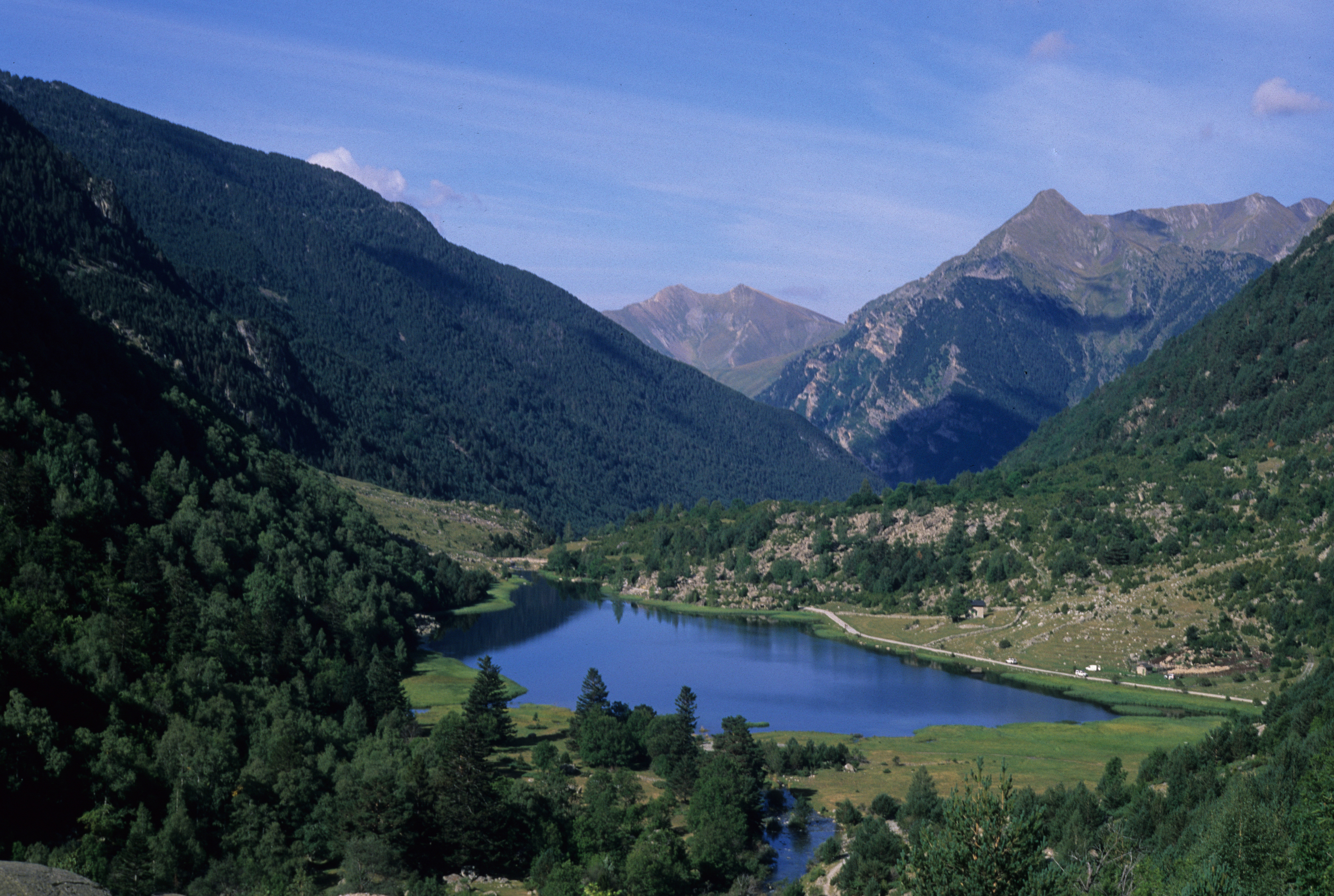
The National Park (14,119 ha) and its Peripheral Protected Area (26,733 ha) is located in the center of the Pyrenean range, in the southern axial chain, in northwest Catalunya (42º 34’ N, 00º 56’ E). It is a high mountain area considered one of the best representations of the Quaternary glacial erosion with typical glacial cirques and "U" shaped valleys. The range of altitudes varies between 1,383 and 3,023 m asl, with a mean altitude of 2,236 m asl. The Aigüestortes National Park has as a particular identity a wide variety of aquatic ecosystems (peatlands, lakes and streams) and few artificial (dammed lakes, small reservoirs and open channels). There are more than 200 lakes (with the local denomination of "estanys") within its boundaries, which make the Park the most important alpine lacustrine area of Europe and, of course, of the Pyrenees. Some of these lakes have been naturally replenished causing the development of peatlands and wet meadows where the stream meanders, locally called "aigüestortes" (literally, "twisted waters"). Climate is of mountain Atlantic type with precipitation abundant all year round (range 1,200 to 1,300 mm) and monthly average usually higher than 100 mm. Temperatures are low with yearly average of 5.2ºC and thermal amplitude 16ºC. The vegetation is a typically alpine landscape of great phytogeographic interest with extensive meadows, scree and snow bed endemic communities. In the montane and subalpine belts there are beech, mixed deciduous, fir, and pine forests, diverse scrubs, and a number of wetlands and peatlands which are the main feature of this space. There are at least eight vulnerable or threatened iconic species of animals living in the Park: Rosalia alpina (rosalia beetle), Salmo trutta (trout), Galemys pyrenaicus (Pyrenean desman), Gypaetus barbatus (bearded vulture), Aquila chrysaetos (golden eagle), Lagopus mutus (ptarmigan), Tetrao urogallus (capercaillie), and Ursus arctos (brown bear).
-
Grassland site in the pre-apine region of S-Bavaria equipped with EC measuring system and lysimeter network for investigation of water, energy, carbon and nitrogen cycling and associated exchange processes with the atmosphere and hydrosphere. The Fendt site is part of ICOS-D and the main site of the TERENO per-alpine Observatory.
-
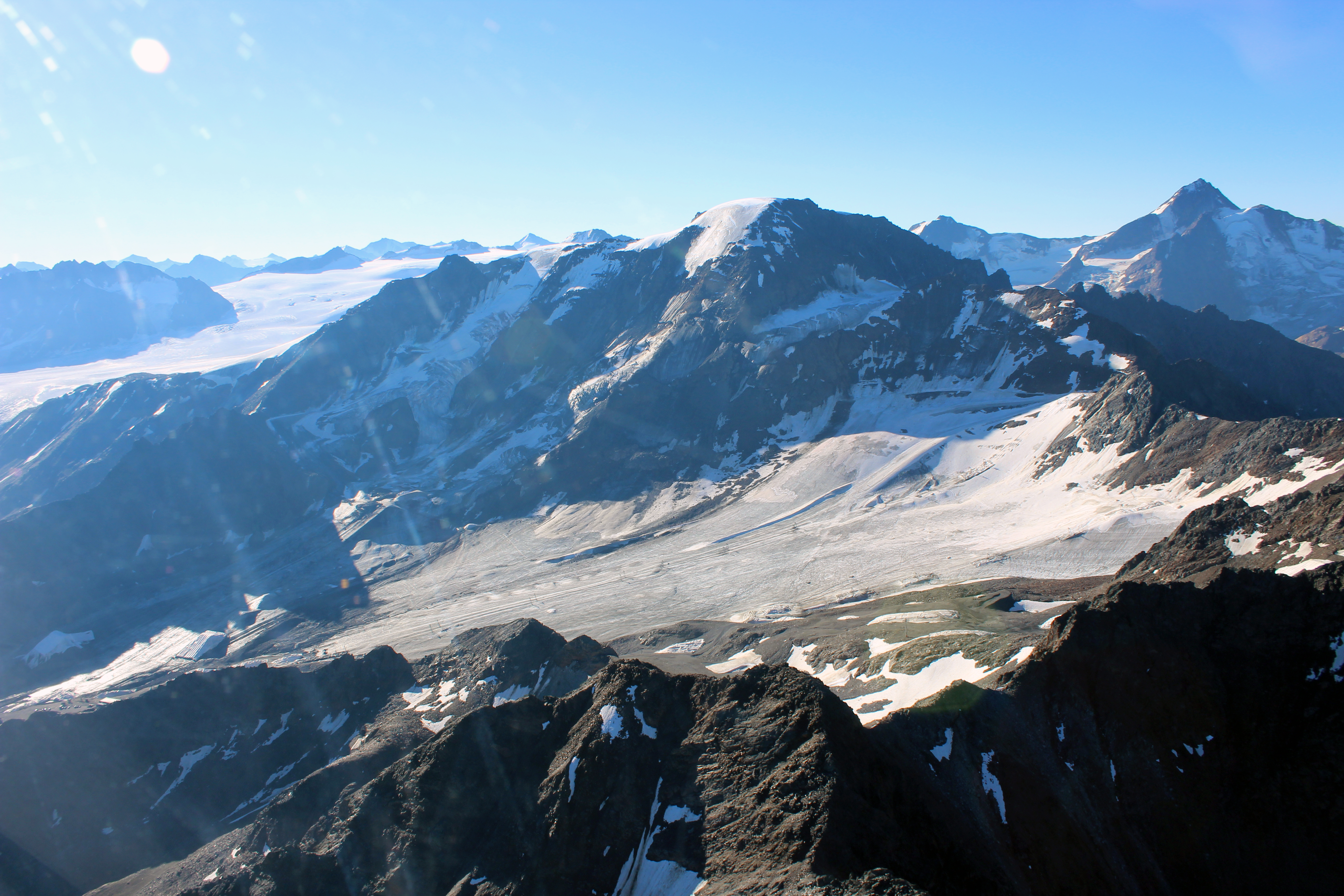
The LTER site Kaunertal reaches from the glaciated peak of the Weißseespitze (3600 m) to the Gepatschferner, the second-biggest Austrian glacier, down to the community of Kaunertal. The Gepatschferner is one of the most thoroughly studied glaciers in Austria, with a chronology of advances and retreats that covers the Holocene. Comprehensive data also exist on changes in the tree line and the distribution of permafrost and rock glaciers. Run-off and mass balance data on the glacier and detailed studies on the geomorphology of the glacier forefield and the role of biota for sediment mobilization complement the studies in the glaciated catchment area. In 2023 we started a project on butterfly monitoring. In 2021 the community of Kaunertal created a museum dedicated to research.
-
SITES Lönnstorp research station is situated in the Scanian agricultural landscape between Malmö and Lund and has a focus on the design, sustainable development and assessment of arable cropping systems, in conventional and organic farming. The research station is available for research within ecology, agronomy, environmental science, agroecology and other disciplines. SITES Lönnstorp research station have access to 60 hectares of conventional and 18 hectares of organic farm land, mainly cultivated with annual crops, representative for agricultural practise in southern Sweden. The station is also a part of SITES, Swedish Infrastructure for Ecosystem Science. SITES is a nationally co-ordinated infrastructure for terrestrial and limnological field research. In 2016, SAFE (SITES Agroecological Field Experiment) was established at the research station. SAFE make it possible to compare four different agroecosystems, a conventional reference system, an organic system, a perennial system and an agroecological intensified system.
-
Processing of time series of satellite and airborne images, with different spatial and spectral resolution, in order to derive water quality maps based on physically based algorithms parametrised with specific optical properties of lake Garda. Generation of spatial and temporal information of different water quality parameters of surface water column and coastal zone. Dedicated actives of calibration and validation of satellite images, algorithms and products.