
river temperature
Type of resources
Available actions
Topics
Keywords
Contact for the resource
Provided by
Years
Formats
Representation types
-
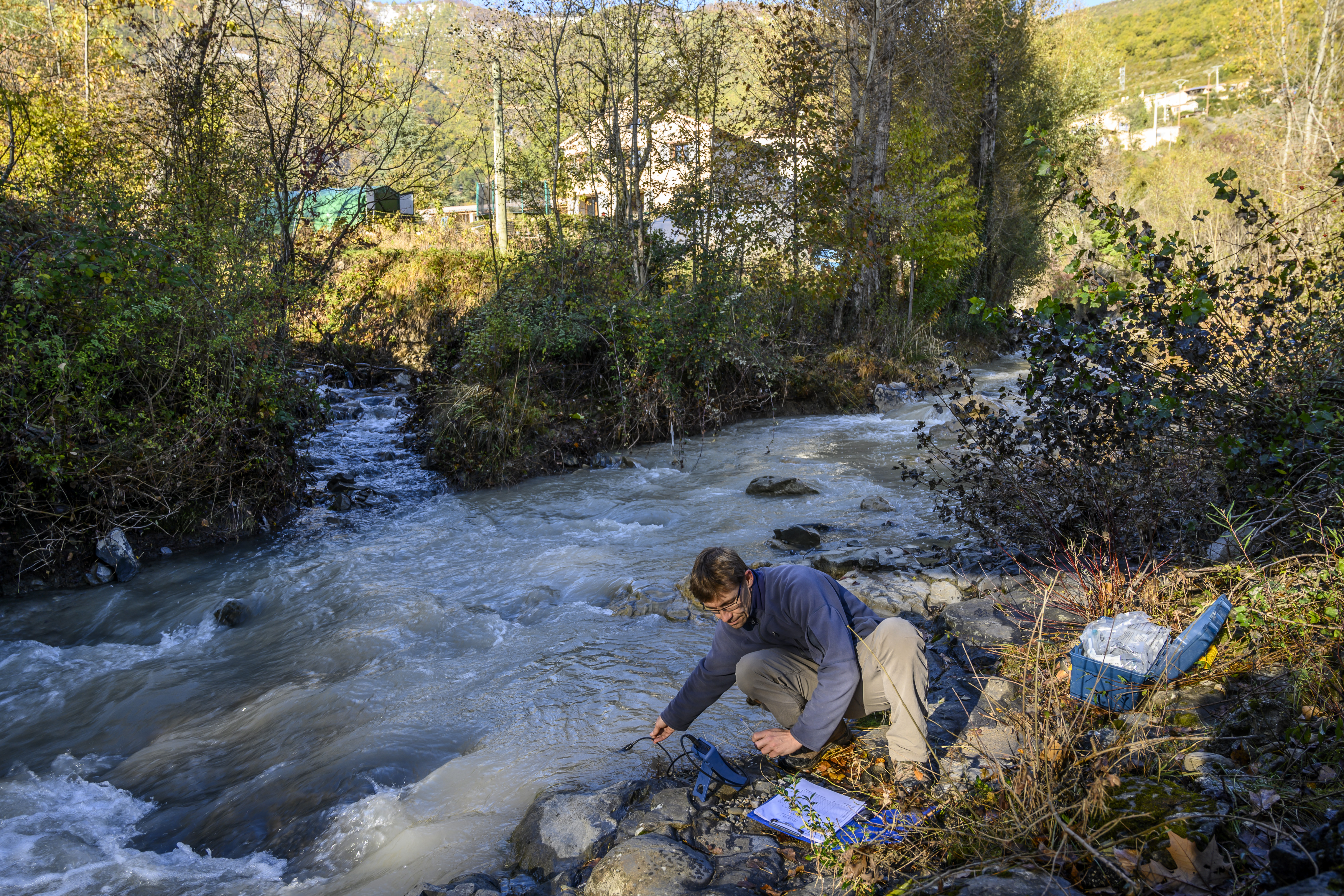
The Galabre site is part of Draix-Bleone observatory, located in the French South Alps, upstream of Digne, on the right side of the Bleone river. The hydrosedimentary station of La Robine-sur-Galabre was created in 2008 to measure water of sediment fluxes from the Galabre catchment, 20 km2. This catchment integrates a diversity of lithologies and land use that are characteristic of the Pre-Alps. The climate is mountainous and Mediterranean. The site is characterized by intense erosion and intermittent sediment fluxes. The variables that are monitored on the long-term include rainfall and meteorology, high-frequency water discharge and suspended sediment concentration (10 minutes), some physico-chemical properties of stream water and sediments.
-
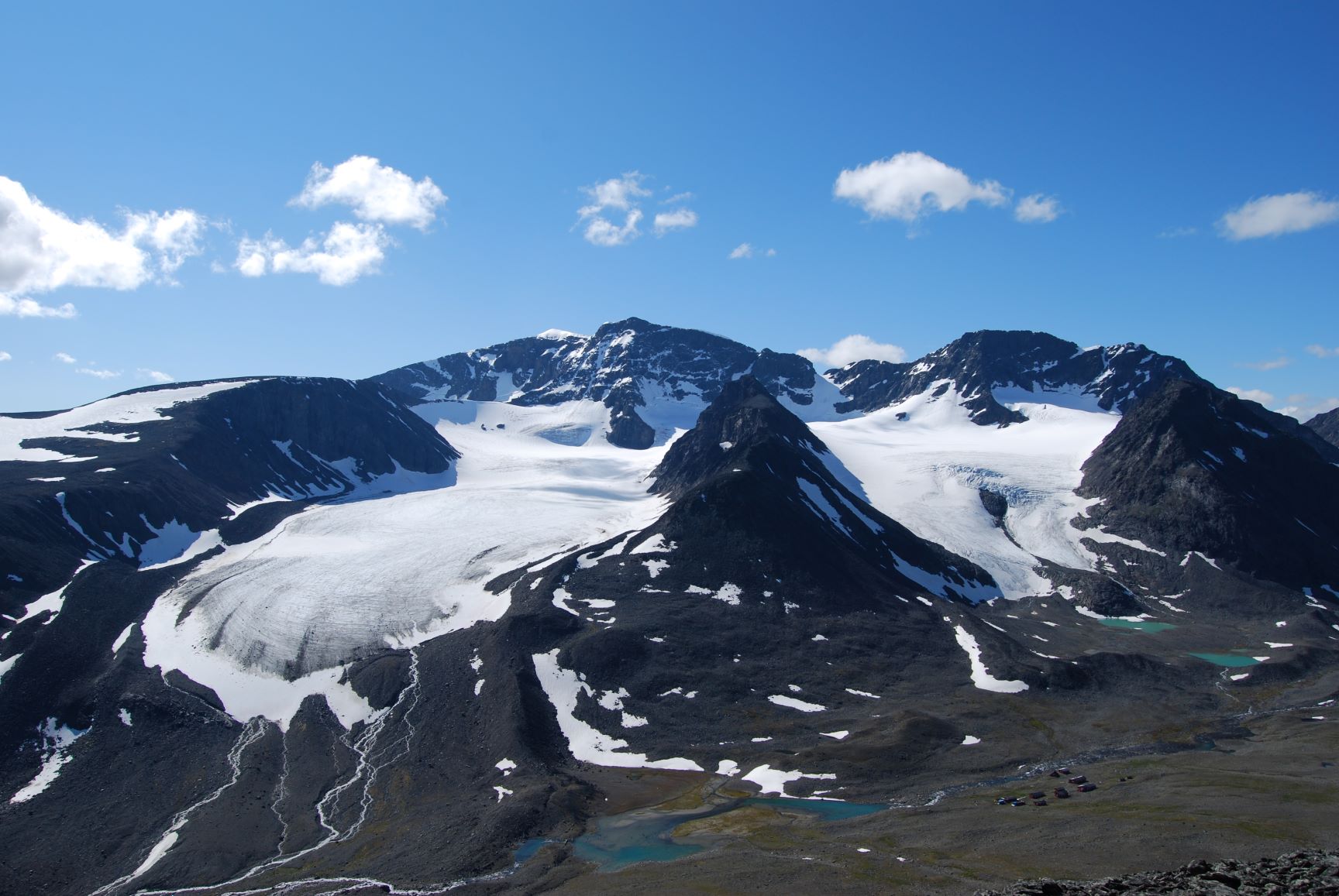
Tarfala Research Station is located at 1130 m a.s.l. in the high alpine Kebnekaise mountains, northern Sweden. The Tarfala valley catchment reaches from 2100 to 500 m a.s.l. Vegetation spans high alpine flora, mountain heath and meadows and the upper mountain birch forest zone. The lake, rivers and glacier meltwater streams is part of the headwaters for the unregulated Kalix River. The station was established in 1946 with the main aim to study glacier massbalance. The best known glacier is Storglaciären which is one of the most well studied glaciers in the world. The glaciers and terrestrial and aquatic ecosystems formed by the harsch climate in this area is now changing rapidly. Over the years the environmental monitoring program has expanded and includes today mountain meteorology, water discharge and chemistry, permafrost and vegetation. The station belongs to Stockholm University and is part of the Swedish Infrastructure for Ecosystem Science (SITES).
-
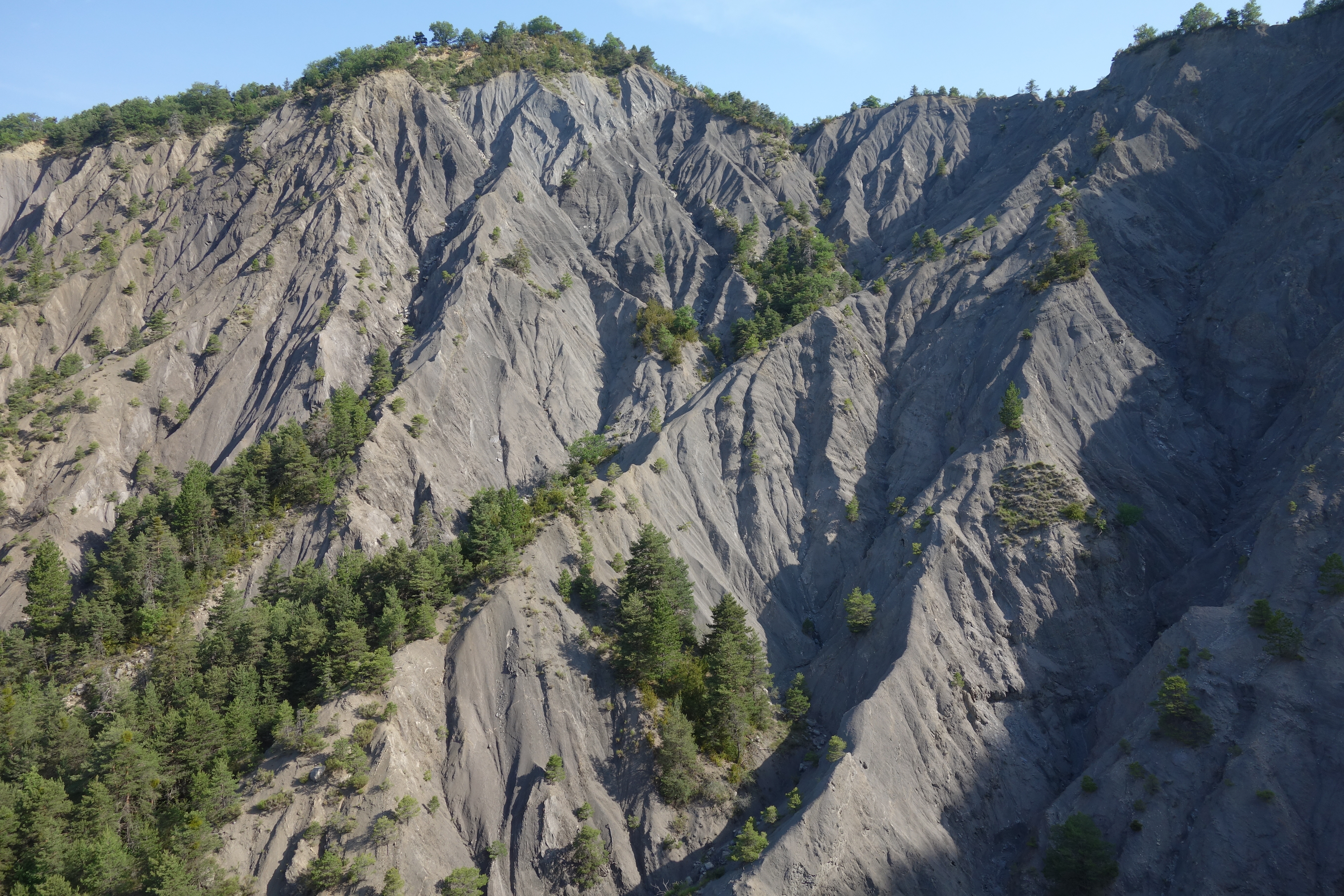
Draix site is part of Draix-Bleone observatory, located in the French South Alps, upstream of Digne, on the left side of the Bleone. Draix site was equipped in 1983 to study mountain erosion and sediment transport. It is composed of 4 catchments, which are equipped to measure water and sediment fluxes, at spatial scales ranging from 0.001 km2 to 1 km2, with contrasted land cover. These catchments are entirely situated on black marls that are very sensitive to weathering and erosion, resulting into a badland topography. One catchment was reforested at the end of the XIXth century whereas the other are mostly denuded. This site is characterized by intense erosion and intermittent sediment fluxes. The variables that are monitored on the long-term include rainfall and meteorology, high-frequency water discharge and suspended sediment concentration (1-10 minutes), event-scale bedload transport, and some physico-chemical properties of stream water and sediments.
-
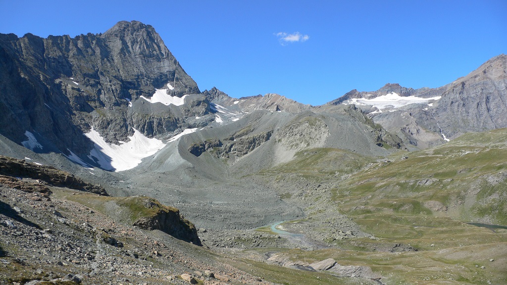
The Bessanese high-elevation experimental site is located in the Western European Alps (Graian Alps, municipality of Balme, Italy). This site is representative of the glacial and periglacial environments of the Alps. In this site, glaciers have been the main morphogenetic agent: the head of the basin hosts a well-developed glacial cirque, while the LIA has left an imposing moraine on the left side of the glacier as an indelible mark in the landscape. Additional cryogenic and atmospheric processes, running waters and gravity have contributed to shape the study area. These latter processes are becoming more and more important, compared to glacier shaping, in the present context of climate change, which led to an impressive-areal and volume reduction of the glacier. Most of the area once occupied by the glacier is now covered with debris which, in many cases, is ice-cored, or contains ice lenses. Downstream of the main lake of the basin, located at an elevation of about 2580 m, the debris forms a large and characteristic rock glacier. Among gravitative processes, rockfalls are particularly common and relevant from the hazard point of view in the study area. dataset available on Pangaea repository: 1. Nigrelli, Guido; Chiarle, Marta; Merlone, Andrea; Coppa, Graziano; Musacchio, Chiara (2022) – Rock temperature variability in the alpine cryosphere. Pangaea Data Publisher for Earth & Environmental Science, https://doi.pangaea.de/10.1594/PANGAEA.950246 2. Nigrelli, Guido; Barbero, Secondo; Chiarle, Marta (2021) – Solar radiation at the Bessanese high-elevation experimental site (Italy). Pangaea Data Publisher for Earth & Environmental Science, https://doi.org/10.1594/PANGAEA.930679 3. Nigrelli, Guido; Chiarle, Marta; Merlone, Andrea; Coppa, Graziano; Musacchio, Chiara (2018) – Rock and debris temperature in the alpine cryosphere. Pangaea Data Publisher for Earth & Environmental Science, https://doi.org/10.1594/PANGAEA.894317
-
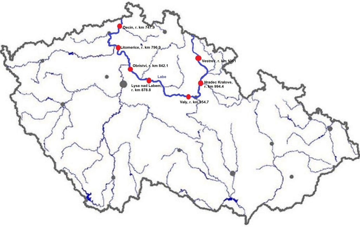
The Elbe River is one of the major rivers in Central Europe. It springs at an altitude of about 1,400 meters in the Giant Mountains in the north of the Czech Republic. It flows through eastern, middle, and northern Bohemia, and its catchment area includes most of Bohemia. The Elbe traverses the northeastern part of Germany and flows into the North Sea. The total river length is 1,094 km. In the Czech Republic, the monitored river length is 371 km and the catchment area includes 49,933 km2. The average flow at the Czech-German borders is 311 m3 s-1. Many weirs dam the watercourse of Elbe River in the Czech Republic. This artificial intervention is crucial for the characteristics of the riverbed, its width, depth, and bottom substrate. The width of the riverbed in the monitored area ranges from approx. 10 m on the upper course to approx. 150 m on the lower course and river sections above the weirs. The depth of the river varies from 0.5 m in the upper parts and below the weirs to more than 5 m in the lower course and above the weirs. The bottom substrate varies from the stony, gravelly, and sandy fractions in shallow and fast-running sections to muddy/silty fractions in slow-running sections above the weirs. The main tributaries of the Elbe in Bohemia are Metuje, Orlice, Jizera, Ploučnice, Vltava, Ohře and Bílina rivers. The catchment area is densely populated. The river is exposed to various sources of pollution (organic, agricultural, and industrial) and hydromorphological pressures (straightening, shortening, regulation of meanders, and fragmentation of river continuity). There are seven permanent monitoring sites on the Elbe River in the Czech Republic: Děčín (river kilometer 747.9), Litoměřice (796.9), Obříství (842.1), Lysá nad Labem (878.8), Valy (954.7), Hradec Králové (994.4) and Vestřev (1051). The Elbe basin long term environmental research has been organised by the Ministry of Environment of the Czech Republic and cooperation institutions since 1993. More than 600 physicochemical parameters, including sensory properties of water, are regularly monitored in at least nine different types of matrices (water, sediment, periphyton, floats, sedimentable floats, benthos, fish tissues, fish fry, and Dreissena polymorpha tissue) and using passive samplers. Among the main monitored characteristics belong balances of macroelements (carbon, nitrogen, oxygen, phosphorus), concentrations of inorganic salts, heavy metals and various organic pollutants such as pesticides, personal care products (including drugs) and other anthropogenic substances in the environment. Characteristics such as abundance and species composition are regularly monitored in fish, macrophytes, macrozoobenthos, phytobenthos and plankton.
-
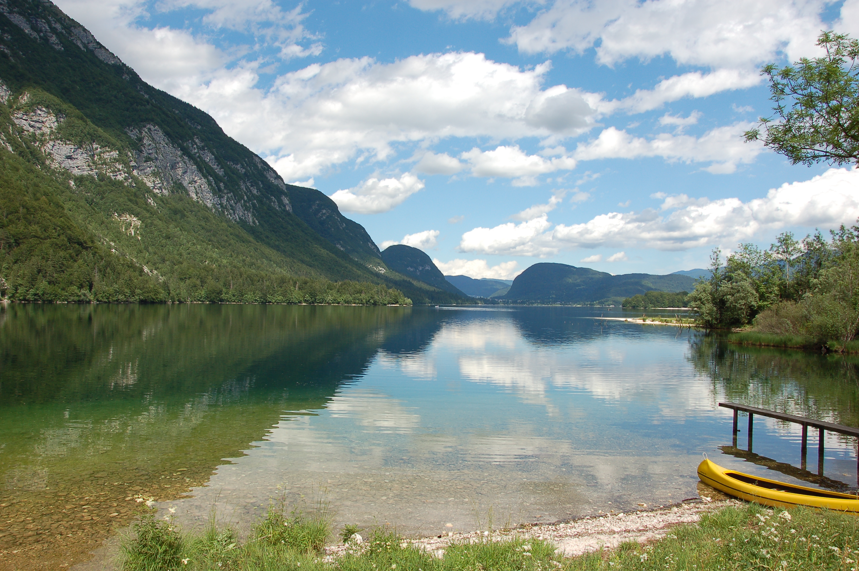
Lake Bohinj is of tectonic-glacial origin and was transformed by the Bohinj glacier. Its surface area is 3.28 km 2 , its volumeWeather conditions and chlorophyll concentrations determine long-term macrophyte community dynamics of Lake...92.5 × 10 6 m 3 and its maximum depth 45 m. It is located at an altitude of 525 m a.s.l. and issurrounded by mountains that are up to 2000 m high. Lake Bohinj is conditioned by the main inflow from River Savica and by several karst springs from the base of Mount Komarča and has a single outflow, River Sava Bohinjka. The residence time of the water in Lake Bohinj is about 4 months, which means that the total volume of the water in Lake Bohinj changes three times a year. The surrounding watershed comprises around 94.3 km2 and is mostly uninhabited, with a large portion extending above the tree line; therefore, the input of nutrients into Lake Bohinj is moderate. This watershed receives about 3300 mm of rainfall a year. Long-term temper-atures show a tendency to a rise. In winter, usually in January, the surface water cools and the lake can be frozen over. From 1961 to 1990, Lake Bohinj was frozen over for a mean of > 50 days/year, while in the decade from 1991 to 2000, the mean number of days with ice cover was reduced to 31 days/year. Since 1990, the lake did not freeze completely in individual years. The majority of the lake catchment area consists of carbon-ate rock, and therefore, the main lake sediment fraction is carbonate, while quartz and feldspar represent a minor part.
-
South-West Bulgaria, Mediterranean catchment
-
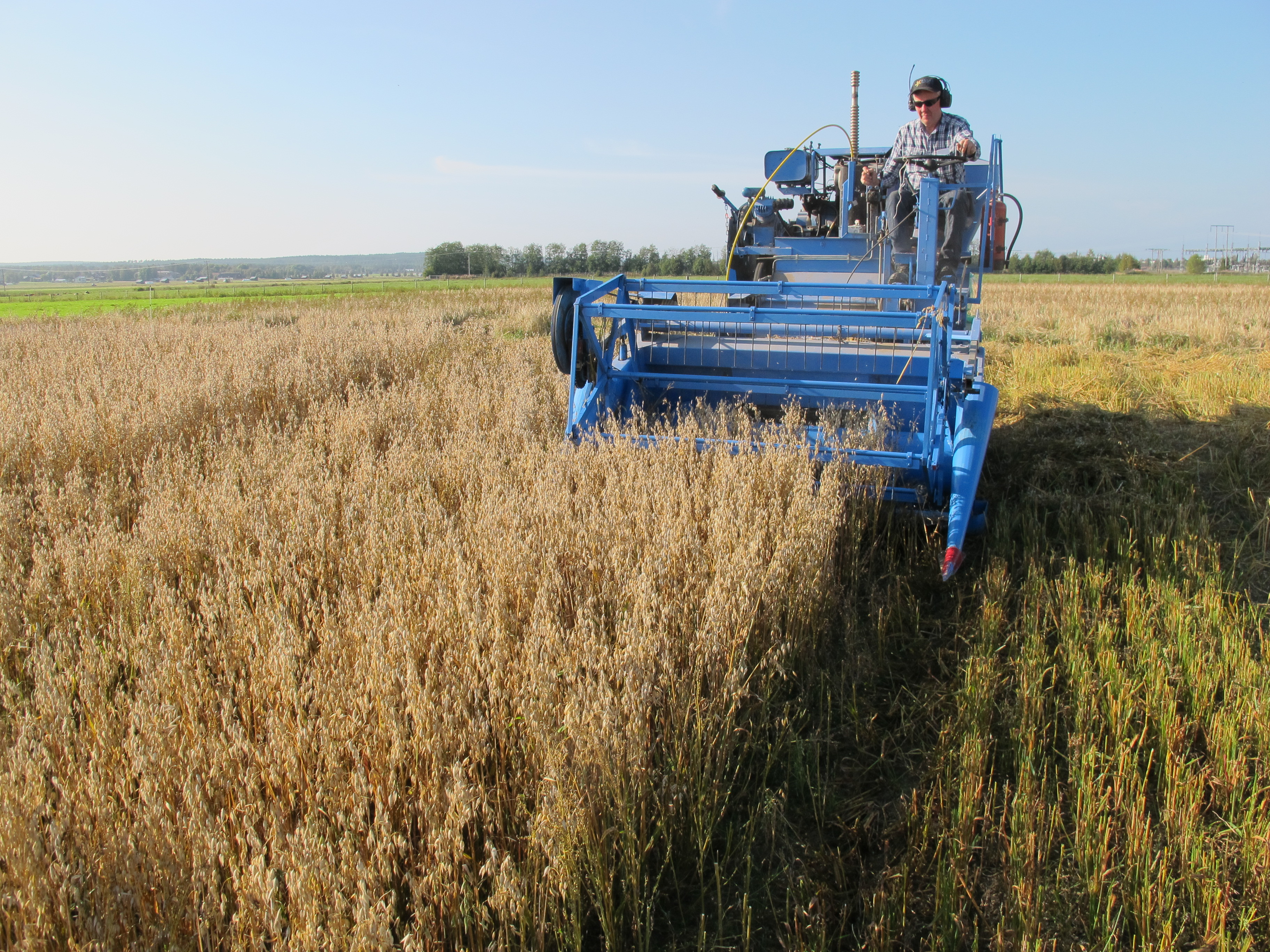
Röbäcksdalen research station was established 1954 and contains a field station and a dairy barn. The field station offers the ability to perform field research in a variety of areas such as agricultural science, biology, agroecology, soil science and environmental science. At the infrastructure it is possible to do research in a variety of areas such as animal science, agricultural science, ecology, phenology, climatology, geochemistry, biology, agroecology, soil science and environmental science. Visitors and users of the infrastructure can get access to the land and a stream collecting drainage and surface runoff-water from the area, animals in the dairy facility, workshop, machines, measuring equipment and techniques, personnel, laboratories and working stations. All data that is gathered within the infrastructure can also be available for the user, most of with is continuously collected data, data from feeding trials, climate data, soil data, data from water samples of runoff-water, data from the catchment area around the station as well as GIS data and data from different long-term-trials. The predominant soil type at the experimental fields is sandy-silt, which is characterized by good water holding capacity and high capillarity, hence the crops seldom suffer from drought here. The humus content is high (3-6%) which means that the soil is not so dense, something that otherwise might be a problem for this soil type. Sandy soil is present in limited areas. We are active in four different locations in northern Sweden. At Röbäcksdalen we manage the station and on the other sites we collaborate with Lantmännen Lantbruk at Lännäs (Västernorrland), Torsta AB at Ås (Jämtland) and Hushållningssällskapet Norrbotten och Västerbotten at Öjebyn (Norrbotten). The dairy barn was built in 2006 and has around 105 dairy cows of the breed Swedish red. The barn can e.g. be used for feed trials and among the equipment are two Greenfeed units that measure greenhouse gases (GHG) produced by the animals. The inclusion of the barn also offers farm scale studies of e.g. production of GHG or N or P flows.
-
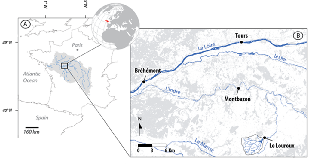
The 25 km² Louroux catchment is located in central France. It is a typical lowland, intensively cultivated catchment with an 11th century pond at its outlet. As in many similar environments, this catchment underwent large landscape changes since the second half of the 20th century: implementation of drainage systems, stream redesign and land reallocation. This resulted in changes in sediment transfer processes and in widespread morphological alterations of water bodies. There is still little combined knowledge on the intensity, processes & sources of sediments in these environments although these are necessary to implement efficient mitigation strategies. Long term sedimentation rates are studied through analysis of sediments accumulated in the pond. Current suspended sediment fluxes are monitored with a high frequency through five hydrosedimentary stations. Fingerprinting techniques are used to trace the origin of sediments.
-
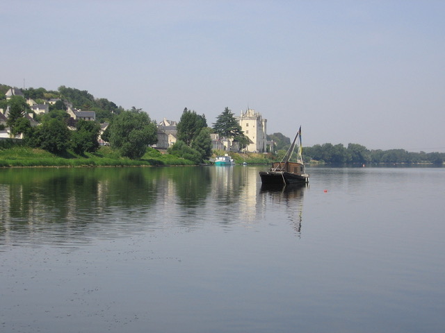
The LTSER Zone Atelier Loire belongs to LTER-France network. The ZAL studies the Loire River basin (127 000 km2) on a long term scale (-15000 years until today). It focuses on the functionning of the hydrosystem, the human societies living there and on the co-evolution hydrosystem – society. The LTSER hosts several study sites subjected to measurement or data collection campaigns during work involving different disciplines as well as managers around a key question. The Maine watershed site is a large area to study dynamics of a low-energy river draining a 22,000 km² basin. The Louroux (Indre-et-Loire) site includes operation of an agricultural catchment area (24 km²). The bog of la Guette (Cher, Sologne, 25 ha) is an instrumented site to follow the rehabilitation of eco-hydrological services (storage of carbon, hydrology, biodiversity). Mareau-aux-prés islands (Loiret, St-Mesmin, 13 ha) is a site subjected to river dynamics which allows to understand the impacts of works carried out in the dyked bed and dynamics of the landscapes.