
seed mass
Type of resources
Available actions
Topics
Keywords
Contact for the resource
Provided by
Years
Formats
Representation types
-
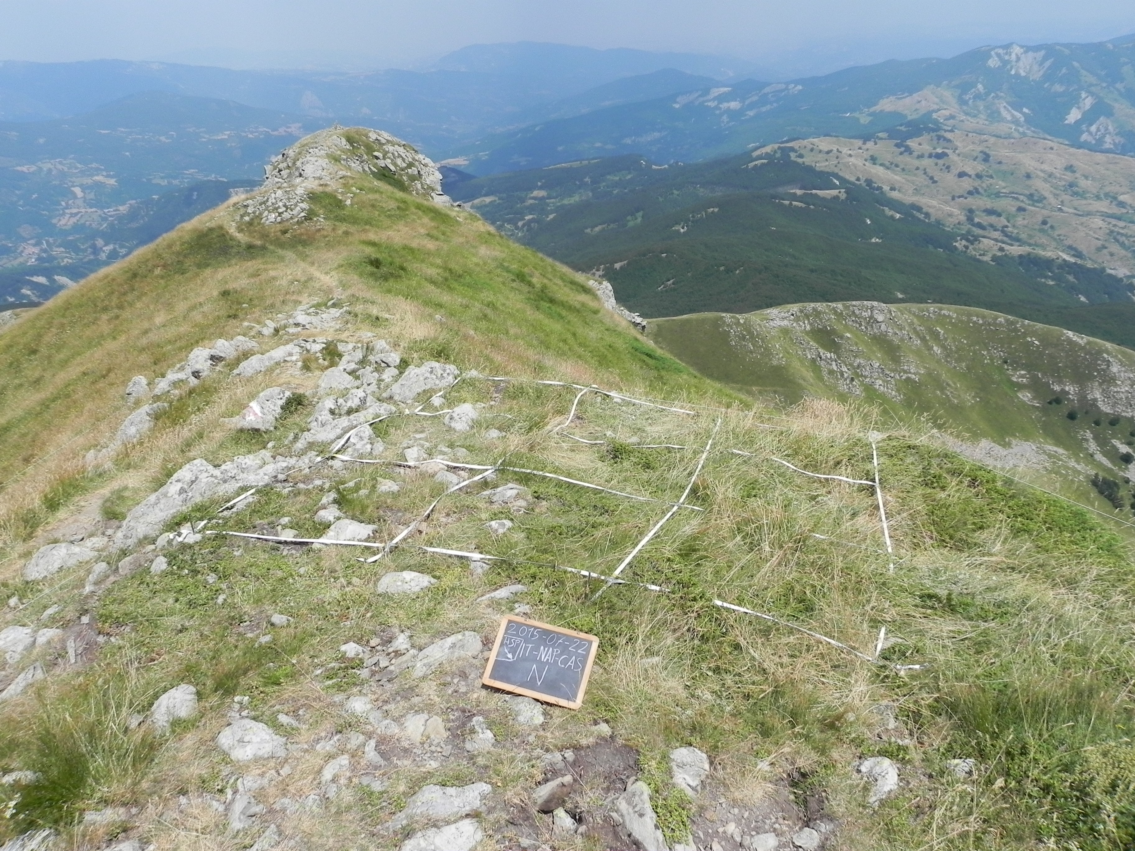
The site consists of “orographic islands” with high elevation vegetation in central Mediterranean basin, along the Apennines mountain range, within the Appennino Tosco-Emiliano National park and partially in the Appennino Modenese Regional park. It includes 64 permanent plots for plant species monitoring, distributed from timberline zone to the subalpine/alpine belt (1722-2000 m), that belong to the GLORIA project’s world network (GLobal Observation Research Initiative in Alpine ecosystems); The plots lie at the top of four summits, displayed along an altitudinal gradient, chosen following the GLORIA Target Region selection criteria. Furthermore, other 26 permanent plots, detached from the GLORIA project, have been settled on mount Prado. The observation and the long-term monitoring of vegetation and alpine plant species population started in 1999. The collection of soil temperature and osmotic potential started in 2001 and 2013, respectively. The site is resurveyed regularly to collect vegetation data (in term of presence/absence and coverage) and climatic data (temperature and osmotic potential data series recorded every 30 minutes by data loggers) in order to assess impacts of climate change on plant communities and single plant species of interest.
-

The Hölstein site is located in in the eastern part of the Swiss Jura mountains (47°26’16.4’’, 7°46’31.1’’; 540 m a.s.l.), in a mixed, temperate forest with an exceptionally high biodiversity and a vigorous tree regeneration. The research plot has a size of 1.6 ha and comprises 540 mature trees. The main tree species are Fagus sylvatica and Picea abies with an admixture of Abies alba, Quercus petraea, Pinus sylvestris, Acer pseudoplatanus, Carpinus betulus, Fraxinus excelsior and Sorbus torminalis. A canopy crane is installed in the center of the research area to access the tree canopies for in situ measurements and for sampling of leaf material. Rainout shelters will be installed in 2019 for conducting a long-term throughfall exclusion experiment.
-
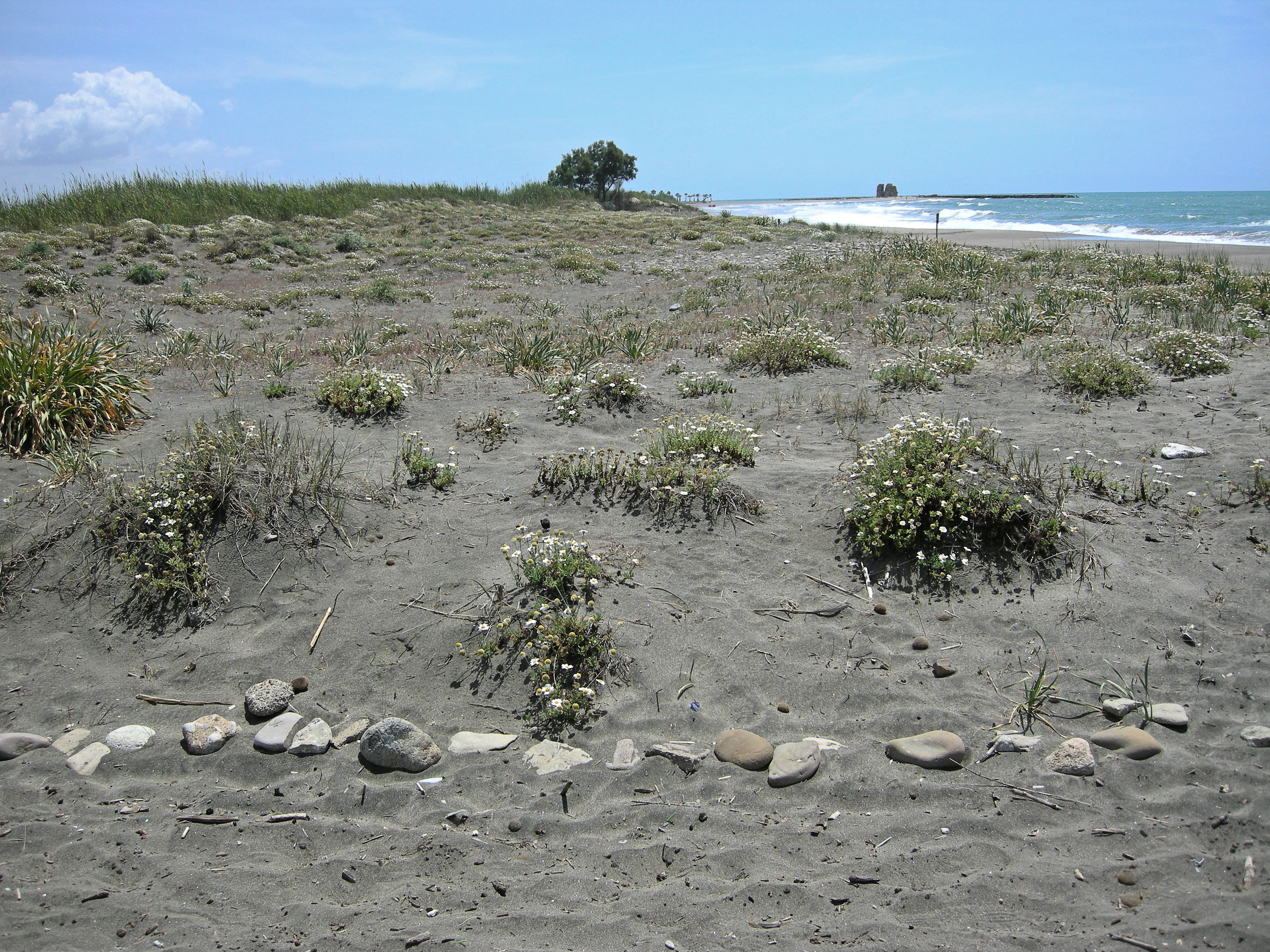
The site, located along the Tyrrhenian coast, north of Rome city, is a Special Protection Area (SPA) for migratory and nesting birds (Anatidae, Ardeidae). The wetland area is one of the last stretches of the Lazio wetlands which have been progressively reclaimed and cultivated during the last century. The flora and the fauna of the site is not only highly specialized but also highly endangered, with a relevant ecological value evidenced in previous studies. The site includes coastal dune habitats of European interest, as the annual vegetation of drift lines, the embryonic shifting dunes, the mobile dunes with Ammophila arenaria and the dune grasslands. There are also habitats related to wet and mud soils, as Mediterranean salt meadows and reed beds dominated by Phragmites australis.
-
The Aelmoeseneie Forest is a 28.5 ha mixed deciduous forest in the community of Gontrode, just southeast of Ghent. The largest part of the forest is ‘ancient forest’, i.e. it is permanently forested since before 1775, while the forest is surrounded by agricultural land (mostly pastures). The soil consists of a silt loam to loam soil (Planosol), overlaying a mosaic of tertiary clayey and sandy deposits with high base saturation starting at 50 cm depth. Forest management is designed to obtain a more natural tree species composition and to conserve biodiversity. More info can be found at www.aelmoeseneiebos.ugent.be.
-

As the largest contiguous pine forest in Switzerland, the Pfyn forest in Canton Valais (46° 18' N, 7° 36' E, 615 m ASL) offers the best conditions for such measurements. In light of this, a WSL research team installed a long-term experiment of 20 years duration in the Pfyn forest. The average temperature here is 9.2°C, the yearly accumulated precipitation is 657 mm (average 1961-1990). The pines in the middle of the forest are about 100 years old and 10.8 m high. The test area has 876 trees covering 1.2 ha divided into 8 plots of 1'000 m2 each (Image 4). Between the months of April and October four of these plots are irrigated by a sprinkler system providing an additional 700 mm of water, annually. In the other four plots, the trees grow under natural, hence relatively dry conditions.
-
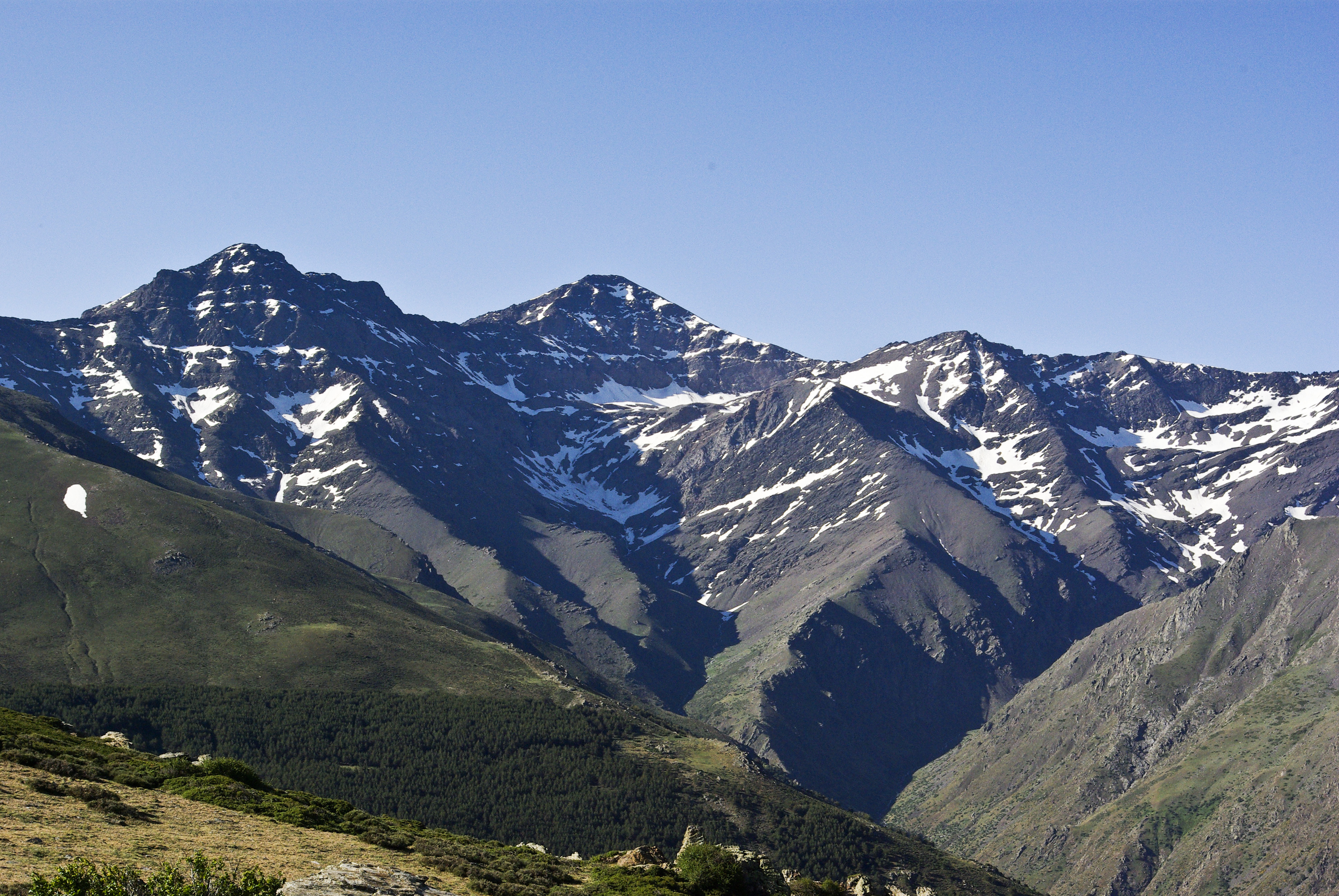
Mountain site, alpine forests Sierra Nevada (Andalusia, SE Spain), is a mountainous region with an altitudinal range between 860 m and 3482 m a.s.l. covering more than 2000 km2. The climate is Mediterranean, characterized by cold winters and hot summers, with pronounced summer drought (July-August). The annual average temperature decreases in altitude from 12-16ºC below 1500 m to 0ºC above 3000 m a.s.l., and the annual average precipitation is about 600 mm. Additionally, the complex orography of the mountains causes strong climatic contrasts between the sunny, dry south-facing slopes and the shaded, wetter north-facing slopes. Annual precipitation ranges from less than 250 mm in the lowest parts of the mountain range to more than 700 mm in the summit areas. Winter precipitation is mainly in the form of snow above 2000 m of altitude. The Sierra Nevada mountain range hosts a high number of endemic plant species (c. 80; Lorite et al. 2007) for a total of 2,100 species of vascular plants (25% and 20% of Spanish and European flora, respectively), being considered one of the most important biodiversity hotspots in the Mediterranean region. This mountain range has several legal protections: Biosphere Reserve MAB Committee UNESCO; Special Protection Area and Site of Community Importance (Natura 2000 network); and National Park. The area includes 61 municipalities with more than 90,000 inhabitants. The main economic activities are agriculture, tourism, cattle raising, beekeeping, mining, and skiing.
-
This LTER-site corresponds with a 0.25 ha intensive forest monitoring plot (ICP Forests Level II) including a 0.25 ha buffer zone. The site is located in a homogeneous stand of Corsican pine (Pinus nigra ssp. laricio var. Corsicana Loud.) planted in 1930 on former heathland and is part of Gewestbos Ravels, a landscape (about 1000 ha) with deciduous and coniferous forests, heathland, bogs and pastures in the northern part of the Campine ecoregion of Flanders. The terrain is gently sloping (1-2 %) and the soil is a well-drained sandy soil (Endogleyic Folic Brunic Albic Arenosol (Dystric)). Ground vegetation is dominated by ferns (Dryopteris dilatata and D. carthusiana) and Vaccinium myrtillus. After a storm in February 2007 felled several trees an understorey of Betula pubescens started to develop. Intensive monitoring was started in 1987 with the main objective to study the effects of air pollution on biogeochemical cycling and forest performance (growth, vitality). This yielded a number of long-term data series including on atmospheric deposition, air quality, soil and soil solution chemistry, tree mineral nutrition, ground vegetation and growth. Monitoring will be continued in the future as a statutory task of INBO.
-
Large forest area, ancient woodland of beech forests, just south of Brussels. In this forest, numerous research activities covering silviculture, forest history, biodiversity inventories, geomorphology, recreation etc... have taken place. Therefore, the complete forest is proposed as an LTSER-platform. Within the forest, two active long-term ecological monitoring programmes are present: - one ICP Forests Level II intensive forest monitoring plot (permanent sampling since 1987) - strict forest reserve monitoring programme on an area of 100 ha (periodic sampling of 15 ha since 1986, extended to 100 ha in 2000) On July 7th 2017, the strict forest reserve 'Joseph Zwaenepoel', together with 4 other unmanaged reserves in the forest, was added to the UNESCO Natural Heritage Site ' Primeval Beech Forests of the Carpathians and Other Regions of Europe' (http://whc.unesco.org/en/list/1133). Besides these, a large number of former research projects, PhD research and a detailed management follow-up make the Sonian Forest one of the best mapped and documented forests in Belgium / Europe.
-
The LTER-site of Wijnendale Forest is a 90 ha scientific zone located in a larger mixed atlantic beech-oak-woodland (300 ha), in the North-West of Belgium, 20 km south of Bruges. The site is located on moderately wet to dry sandy soils. The site is an ancient woodland that used to be managed as coppice with standards. Over the last 100 years it was gradually transformed to a mixed high forest, mainly of oak and beech. The site contains - an ICP Forests Level II plot (0.25 ha), in which effects of air pollution on the forest ecosystem are monitored, according to standard protocols. - a strict forest reserve of 65 ha: here, natural dynamics of forest structure and ground vegetation are monitored, and its effects on biological diversity. - a 25 ha buffer zone, containing both forest and open grassland (extensively managed for nature conservation), where 'open field' measurements are performed. The sampling network in the strict reserve includes >100 sampling plots (0.1 ha) combined with a 1 ha core area. In these plots, full dendrometric surveys (tree position, species, DBH, height, ...) and ground vegetation relevees are performed every 10 years. Additionally, standardised sampling of saproxylic beetles, mosses and fungi were performed and high-resolution air-borne LIDAR and hyperspectral data were recorded in 2012-2014. Main aims for the future are the continuation of the observational networks to provide longer robust time-series that allow more thorough analysis and investigation.
-

The ZA PYGAR covers the whole Garonne river basin up to the upper part of the Gironde estuary (La Reole station). Within this territory, research is structured around 4 main sites: the Pyrénées mountains, covering the upstream part of the Garonne river basin (PYRénées site), the farmland of the foothills of the Pyrénées (Vallées et Coteaux de Gascogne site), the Garonne river (Axe Fluvial Garonne site) and the basin of two tributaries of the Garonne river in the Massif Central moutains (Aveyron-Viaur site).