
seedling growth rate
Type of resources
Available actions
Topics
Keywords
Contact for the resource
Provided by
Years
Formats
Representation types
-
The Sani Environmental Observatory (S.E.O.) is located within a mature, near-coastal Aleppo pine (Pinus halepensis L.) ecosystem at the peninsula of Kassandra, in Chalkidiki, Greece. It is part of the Stavronikita forest, which comprises approximately 300 ha of land covered mainly by forests and to a lesser extend by shrubs and pastures. The Observatory aims primarily at the assessment of the carbon and water balance of this typical low-elevation forest ecosystem to the ongoing climatic shift. Such ecosystems may be prone to the intensified heat and drought events, as well as to the associated insects’ and pathogens’ outbreaks, which are increasingly occurring at the Mediterranean region and particularly at its eastern part. Although Aleppo pines, as well as other Mediterranean pines, are generally adapted to the region’s xerothermic conditions, the in-depth understanding of their ecophysiological and growth responses will allow us to predict the potential of such ecosystems to adapt to climate change. SEO also serves to assess the carbon stocks and fluxes and the contribution of these natural, old-growth ecosystems to carbon sequestration and, thus, to climate change mitigation. S.E.O. is developed by the Forest Research Institute (Lab of Forest Ecophysiology) of the Hellenic Agricultural Organization Dimitra with the support of Sani Resort SA, the owner of the studied forest ecosystem, presenting a nice example of collaboration between the research community and the private sector. Given that SEO is located at a region of high touristic and aesthetic value, close to a wetland and the sea, the Observatory also plans actions to familiarize people with environmental monitoring and the multiple functions and services of the studied Mediterranean ecosystem.
-
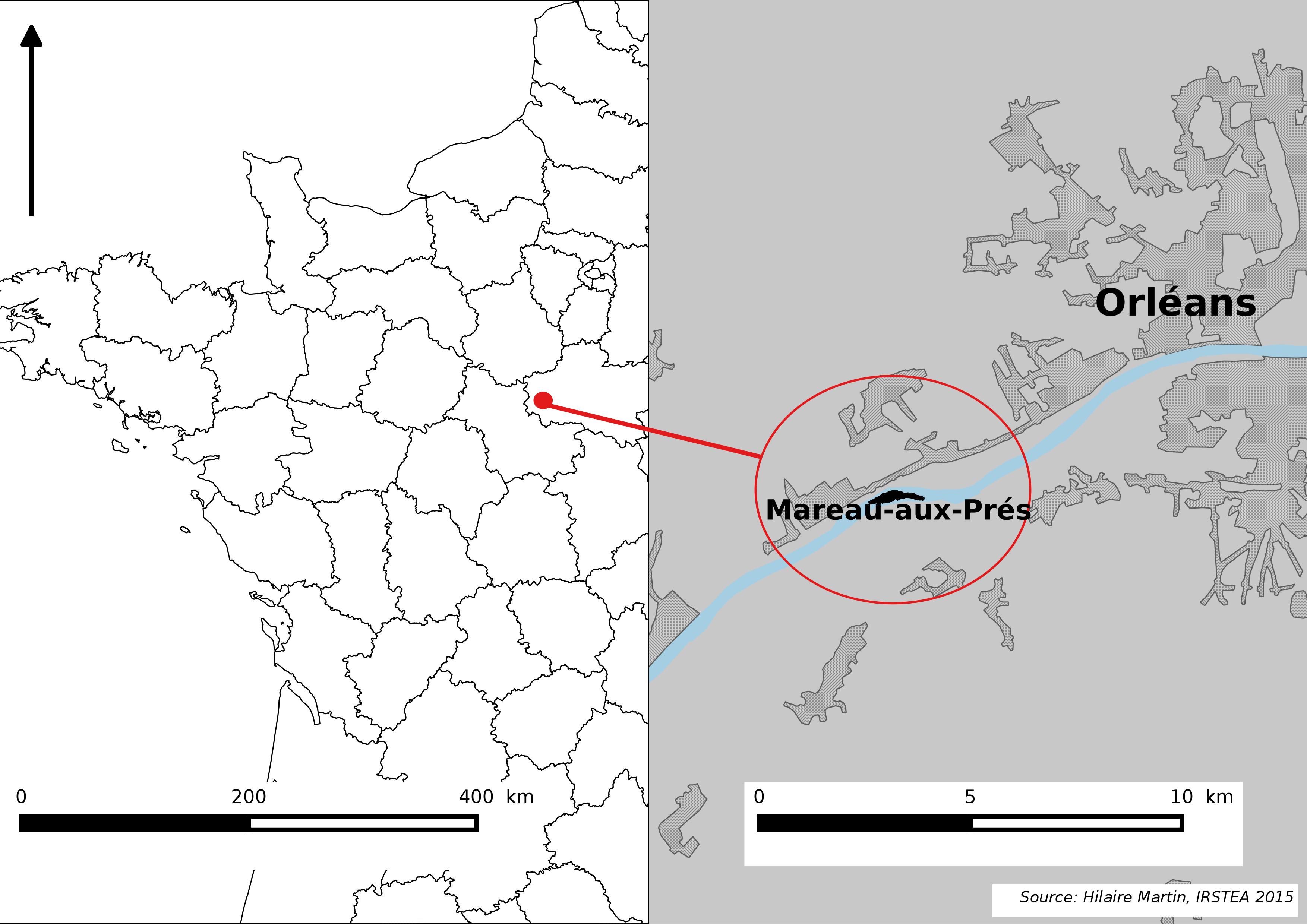
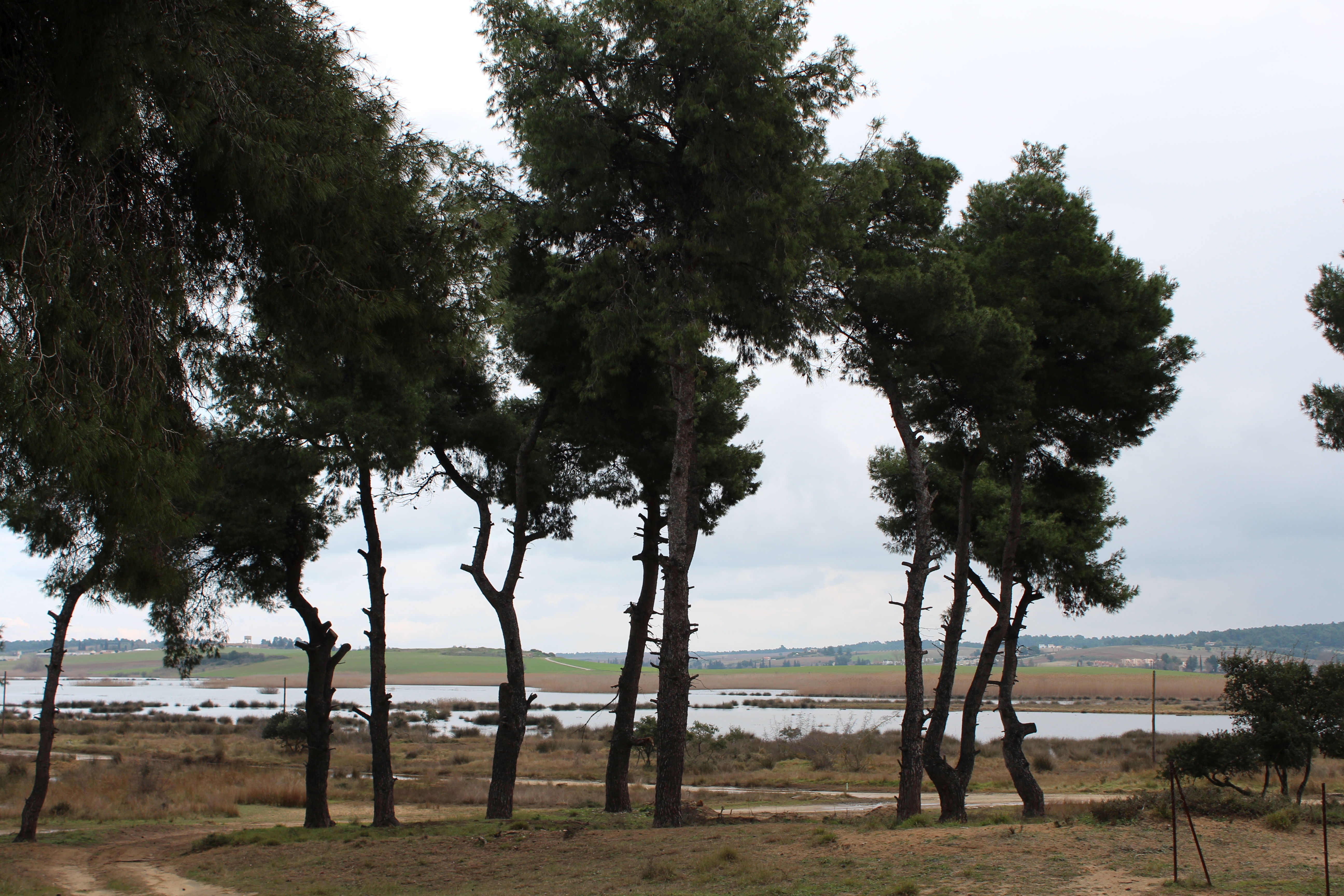
The Mareau-aux-Prés islands, along the Loire river, are characterized by a multiple channel pattern, where natural limestone riffles influence the morphology and spatial distribution of vegetated islands, secondary channels and alluvial bars. Within these islands, in september 2012, fluvial management operations (FMO) were launched. The vegetation of the central sandy-gravelly bar (3 ha area) was uprooted and the bar level lowered in order to maintain the flow capacity of the river. A new sandy-gravelly bar appeared in spring 2013, ideal field support for studying long-term ecological issues. A multidisciplinary research program (‘BioMareau’ project) is currently being conducted from 2012 to 2019, focusing on biodiversity recolonization and on interactions and feedbacks between biotic and abiotic compartments.
-

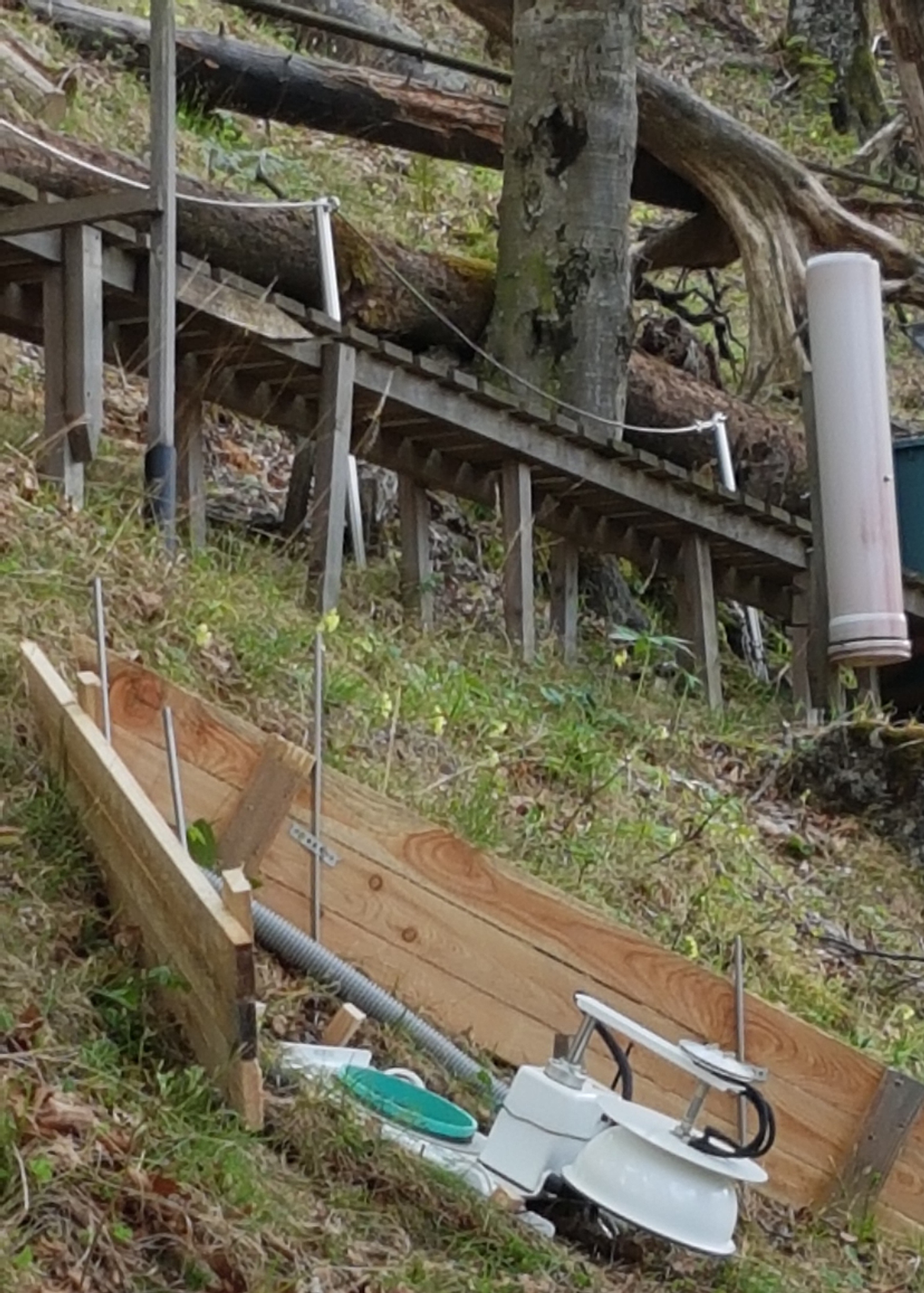
As the largest contiguous pine forest in Switzerland, the Pfyn forest in Canton Valais (46° 18' N, 7° 36' E, 615 m ASL) offers the best conditions for such measurements. In light of this, a WSL research team installed a long-term experiment of 20 years duration in the Pfyn forest. The average temperature here is 9.2°C, the yearly accumulated precipitation is 657 mm (average 1961-1990). The pines in the middle of the forest are about 100 years old and 10.8 m high. The test area has 876 trees covering 1.2 ha divided into 8 plots of 1'000 m2 each (Image 4). Between the months of April and October four of these plots are irrigated by a sprinkler system providing an additional 700 mm of water, annually. In the other four plots, the trees grow under natural, hence relatively dry conditions.
-

Berchtesgaden National Park was established in 1978 and is the only German national park located at the Alps. It comprises three major valleys and covers an elevantional range from 600 to 2700 m. Ecosystems include montane mixed forest and subalpine coniferous forest, alpine grasslands, pastures and rocky habitats. The Department for Research and Monitoring is linked to the Techincal University of Munich. It conducts monitoring on climate, hydrology, ecosystem dynamics and biodiversity. Main research topics include drivers of natural ecosystem dynamics, human impacts on ecosystems and climate change effects on ecosystems.
-

The ZA PYGAR covers the whole Garonne river basin up to the upper part of the Gironde estuary (La Reole station). Within this territory, research is structured around 4 main sites: the Pyrénées mountains, covering the upstream part of the Garonne river basin (PYRénées site), the farmland of the foothills of the Pyrénées (Vallées et Coteaux de Gascogne site), the Garonne river (Axe Fluvial Garonne site) and the basin of two tributaries of the Garonne river in the Massif Central moutains (Aveyron-Viaur site).
-

The Cairngorms National Park is one of 15 National Parks in the UK (one of two in Scotland) and is Britain's largest National Park (4,528 km2). It is the location for some of the most spectacular landscapes in Britain and is home to an incredible diversity of wildlife and plants. http://cairngorms.co.uk/the-park/facts-figures/ The aims of the National Park are: • To conserve and enhance the natural and cultural heritage of the area; • To promote sustainable use of the natural resources of the area; • To promote understanding and enjoyment (including enjoyment in the form of recreation) of the special qualities of the area by the public; • To promote sustainable economic and social development of the area’s communities. Cairngorms National Park, seven broad habitats can be identified: • Enclosed farmlands • Woodlands • Open waters (rivers, lochs, wetlands and floodplains) • Mountains • Moorland • Semi-natural grasslands • Urban • Population of c17,500 • 25.8% of population over 60 (higher than Scottish average) • Average health index in top 25% of Scotland (based on deprivation indices) • Extensive core paths network • 55 Munros including 5 summits over 4000 feet • 3 ski centres • National Cycle Network Route 7 • 1 Long Distance Route (Speyside Way) • Relatively low atmospheric pollution • Annual precipitation over 2250mm on summits and under 900mm in straths • Average annual snow cover 200 days on summits and 50 days on low-ground • Prevailing winds from south-west
-
Small agricultural catchment (320 ha) with 30 years of data to study impact of climate change and agricultural practices on soil erosion, weathering rate and river fluxes. Continuous measurements with sensor: river discharge, Temperature, pH, conductivity, turbidity, dissolved oxygen, nitrate Weekly samples and high resolution sampling during storm runoff: major cations and anions, alkalinity, pH, dissolved silica, conductivity, total suspended solids, stable isotopes (13C of DIC, 2H and 18O of H2O, 15N of nitrates), heavy metals, some pesticide molecules Climatological station, rain collector for precipitation chemistry, soil solution station with lysimetric plate at different depths. Continuous measurement since 2004 of CO2, N2O, water vapor, energy exchange in the soil-vegetation-atmosphere continuum thanks to Eddycovariance and closed chamber methodologies (see OZCAR-RI Regional Spatial Observatory in the South West France contribution) Collaboration with the Aurade farmer association for fertilizer and pesticide inputs, cultivation, agricultural practices... Aurade experimental catchment and flux site are an international field site of the Critical Zone Exploration Network CZEN and of ICOS network, a field site of the French Research Infrastructure OZCAR and it is also a site of the French LTSER ZA PYGAR "Zone Atelier Pyrénées-Garonne". and a regional Platform of Research and Innovation-Midi Pyrénées.
-
The Zöbelboden was established in 1992 as the only Integrated Monitoring station in Austria under the UN Convention on long-range transboundary air pollution (CLRTAP). In 2006 it became part of LTER Austria. The Zöbelboden covers a small forested catchment (90 ha) of a karstic mountain range (500 to 950 m above sea level) in the Kalkalpen National Park. Monitoring and research is focussing on climate change effects on forest ecosystems, the forest carbon and nitrogen cycle, biodiversity, and air pollution effects on forested catchments. The Zöbelboden represents one of the best known karst catchments in Europe with long-term data series of the major components of its ecosystems. The site is part of many national and international monitoring and research networks (ICP Integrated Monitoring, EMEP, LTER, forestREplot, SoilTemp, LifePlan, IG-L, EU NEC-D, etc.). The Zöbelboden is managed by the Environment Agency Austria with technical support of the Kalkalpen National Park and the Austrian Federal Forests.