
snow water equivalent
Type of resources
Available actions
Topics
Keywords
Contact for the resource
Provided by
Years
Formats
Representation types
-
Øvre Heimdalen is located by Valdresflya in the eastern part of Jotunheimen on the border between the municipalities of Øystre Slidre and Vågå. The valley floor, which is oriented east-west, is at an altitude of 1,100 metres. The surrounding mountains reach over 1,800 m above sea level. Birch forest grows on the south-facing valley side, but the rest of the area is above the tree line. Research activity in Øvre Heimdalen began in 1957 with documentation of the trout population in Øvre Heimdalsvatn, and how the biomass, growth rate and age composition of the population were affected by environmental conditions.
-
Cime bianche, Colle Superiore di Cime Bianche, (Valtournenche, Aosta), +398720 +5086095; Valle d'Aosta region
-
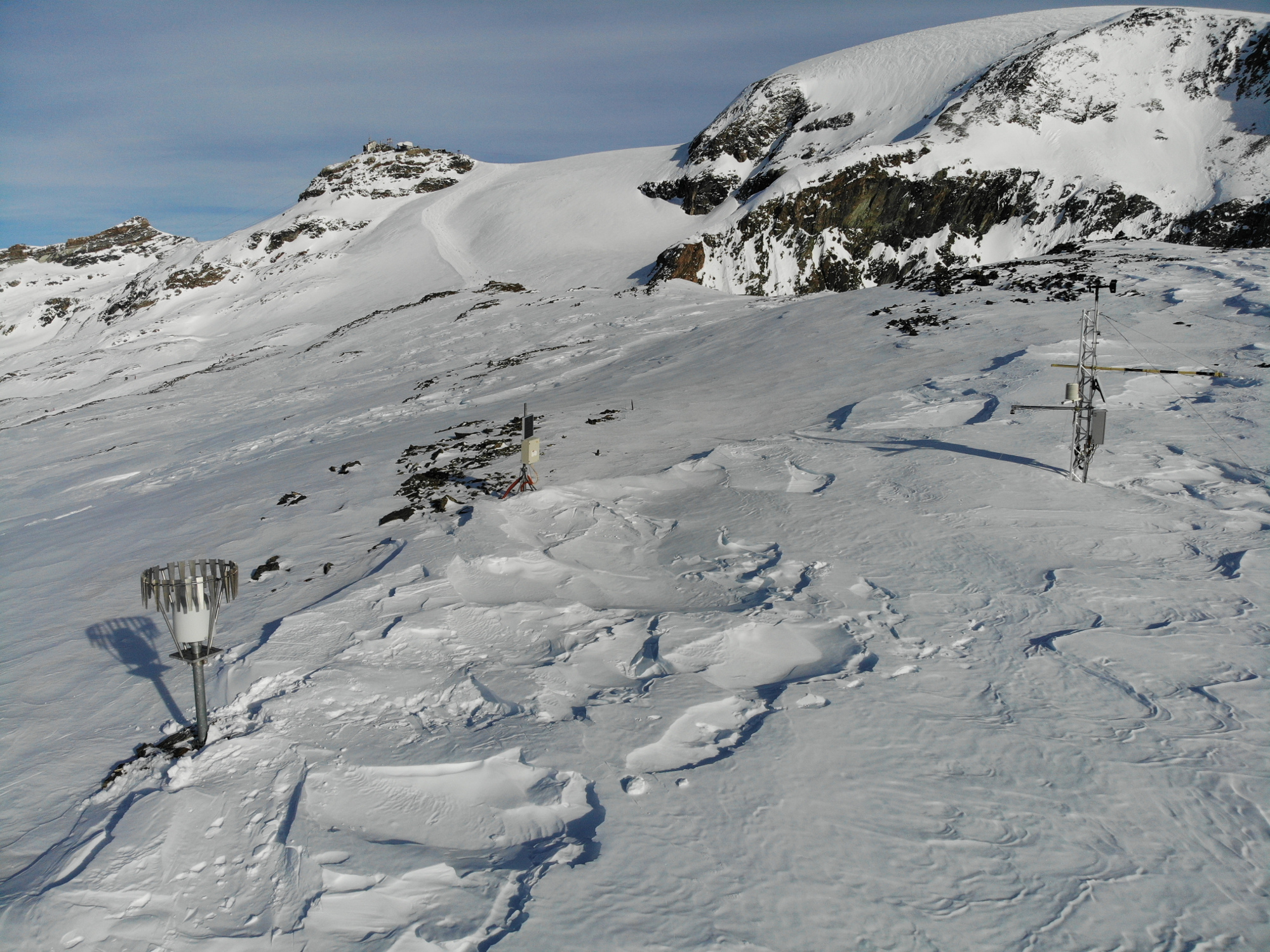
The Hallstätter Glacier is the largest glacier in the northern Limestone Alps. The Hallstätter Glacier is oriented to the northeast and is bordered by Rock walls. The Large plateau above 2550 m.a.s.l. is connected by three short tongues. The largest altitude zone in terms of area is between 2550 m and 2600m. The highest point of the glacier is at 2905 m, the lowest point is on 2240 m. With an area of 2.623 km² (glacier boundary 2020), the glacier lost half of its extent compared to the glacier peak in 1856. In the past 10years, the area has increased by around 13 %.
-
The Venedigerkees in the Hohe Tauern National Park is the easternmost tributary glacier to the former tongue of Obersulzbachkees. As a result of the strong retreat of Obersulzbachkees, the glacier disintegrated into several tributary glaciers, with a large lake remaining at the location of a famous serac zone, the 'Türkische Zeltstadt'. Mass balance of the Venedigerkees is measured since 2011/12 with the direct or glaciological method. Furthermore, an automatic weather station was built between Venedigerkees and Keeskogel in 2018.
-
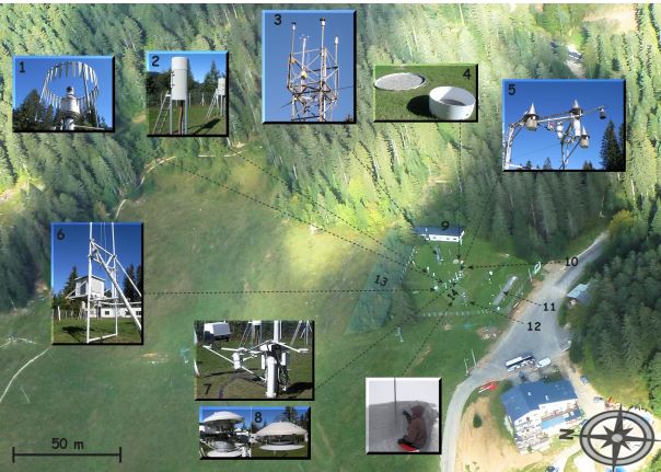
The Col de Porte pilot site is located near Grenoble, in the Chartreuse massif (elevation : 1325m, latitude : 45°30’N, longitude : 5°77’ E). At this mountain site located in a grassy meadow surrounded by a coniferous forest; all the measurements are located within an flat area of 50 × 50 m. Meteorological and snow parameters are recorded hourly since 1961. These parameters are : - Air temperature and relative humidity of air - Incoming and outcoming short and long-wave radiations - Wind speed and direction - Precipitation - Snow depth, snow water equivalent - Settlements and snow temperatures of the different layers of the snowpack Weekly snowpack profiles are also carried out, including major stratigraphic properties of snow (temperature, density, liquid water content, snow type). All sensors are located within a radius of a few tens of meters. (1) Geonor precipitation gauges (3 sensors) and OTT2 (1 sensor), (2) PG2000 heated and non-heated precipitation gauges, (3) windspeed measurements at the top of the 10 m meteorological mast and at the same level of the precipitation gauges, (4) lysimeters (2 sensors), (5) snow depth and surface temperature sensors and settling disks, (6) temperature and relative humidity of air sensors placed in the shelter, (7) Incoming and outcoming longwave and shortwave radiation sensors placed on the rotating arm, (8) close-up on the 4 components radiation sensors, (9) building (cold room, data acquisition, lab space), (10) cosmic rays counter for SWE measurements, (11) former experimental area for the study of road/snow interactions, (12) automatic snow and weather station Nivose for testing purposes (generally used in remote mountain areas), (13) forest area impacted by the cut in 1999, (14) snow pit area, Fore more information refer to : Morin, S., Lejeune, Y., Lesaffre, B., Panel, J.-M., Poncet, D., David, P., and Sudul, M.: An 18-yr long (1993-2011) snow and meteorological dataset from a mid-altitude mountain site (Col de Porte, France, 1325 m alt.) for driving and evaluating snowpack models, Earth Syst. Sci. Data, 4, 13-21, doi:10.5194/essd-4-13-2012, 2012
-
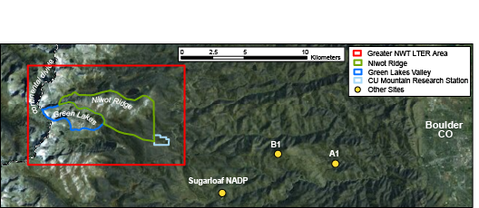
The Niwot Ridge Long Term Ecological Research (LTER) site was established in 1980 with support from the National Science Foundation. The topography, climate and biota of the research site are representative of alpine ecosystems in the southern Rocky Mountains, including extensive expanses of alpine tundra and subalpine coniferous forests, as well as a cirque glacier (Arikaree Glacier), a variety of glacial landforms, lakes and moraines, cirques, talus slopes, patterned ground, and permafrost. The LTER site includes Niwot Ridge, the southern-adjacent Green Lakes Valley, and the University of Colorado’s Mountain Research Station (MRS). Niwot Ridge is part of the Roosevelt National Forest and has been designated a United Nations Educational, Scientific and Cultural Organization (UNESCO) Biosphere Reserve and an Experimental Ecology Reserve (USDA Forest Service). The Green Lakes Valley is a part of the City of Boulder Watershed. The MRS is an interdisciplinary facility devoted to the advancement of the study of mountain ecosystems, providing research and educational opportunities for scientists, students, and the general public.
-
Tarfala Research Station is located at 1130 m a.s.l. in the high alpine Kebnekaise mountains, northern Sweden. The Tarfala valley catchment reaches from 2100 to 500 m a.s.l. Vegetation spans high alpine flora, mountain heath and meadows and the upper mountain birch forest zone. The lake, rivers and glacier meltwater streams is part of the headwaters for the unregulated Kalix River. The station was established in 1946 with the main aim to study glacier massbalance. The best known glacier is Storglaciären which is one of the most well studied glaciers in the world. The glaciers and terrestrial and aquatic ecosystems formed by the harsch climate in this area is now changing rapidly. Over the years the environmental monitoring program has expanded and includes today mountain meteorology, water discharge and chemistry, permafrost and vegetation. The station belongs to Stockholm University and is part of the Swedish Infrastructure for Ecosystem Science (SITES).
-
The Gesäuse Nationalpark and the Johnsbach valley belong to the Ennstal Alps, a part of the Northern Limestone Alps. They are situated in the province of Styria in the center of Austria. Together, they form the joint test site named Gesäuse-Johnsbachtal. This region is characterized by a mountainous landscape which is cut by the river “Enns”. In the north, it borders Eisenwurzen Nature Park and is only 6 km away from the Kalkalpen, a National Park in Upper Austria. In the south, the borders are the Eisenerzer Alps. The total area of the site is about 155 km². The terrain shows a great elevation range from 600-700 m in the Johnsbach valley to over 2300 m in the summit region of the Gesäuse, with Hochtor (2369 m) being the highest mountain. Due to the great range of altitude differences within small areas the Gesäuse-Johnsbachtal shows extremely diverse habitats and, consequently, species of animals and plants. In general, the landscape is dominated by mountain forests along with high Alpine rock formations and meadows. These complex topographic, hydrological, geological, geomorphological and meteorological conditions pose a scientific challenge for all kinds of environmental monitoring and modeling.
-
The "Istituto Scientifico Angelo Mosso" research site is located on the watershed between Piedmont and Valle d'Aosta (NW-Italy), in the Municipality of Alagna Valsesia (Monte Rosa massif). The Scientific Laboratories of the "Angelo Mosso Institute" at Col d’Olen (2901 m a.s.l.), the heart of this research site, were built between 1905 and 1907, when it became clear that the Capanna Regina Margherita on Monte Rosa (4554 m a.s.l.), as a high-elevation research centre, had become insufficient to the increasing number of requests for use by the international scientific community. From here the idea promoted by Angelo Mosso (1846-1910), professor of human physiology at the University of Turin, to add an additional structure to the Observatory of the Capanna Regina Margherita for make larger laboratories available to researchers and allow study stays at high elevation. This project soon became a reality thanks to the intervention of Queen Regina Margherita, Ministries of Education and Agriculture, the Italian Alpine Club and various personalities of the time. The research conducted at the Institute did not concern only human physiology, but also other disciplines, including alpine meteorology and glaciology, thanks also to the presence of the Meteorological Observatory that flanked the Institute, directed in the years 1925-40 by Umberto Monterin. It is now home to an automatic snow and weather station, managed by the Alpine Troops-Meteomont service. In addition to the University of Turin, the research groups that operate at the site and contribute to data collection and implementation are currently CNR-IRSA, Alpine Troops Command-Service Meteomont, Monterosa 2000 SpA and Monterosa SpA (Monterosa Ski), Protected areas of Valsesia, ARPA Piemonte, ARPA Valle d'Aosta and Sesia Val Grande Geopark. In addition to the valuable historical series of climate data, a series of research activities are devoted to the study of snow-soil-vegetation interactions, with particular reference to carbon dynamics e soil nitrogen (Magnani et al. 2017a,b; Freppaz et al. 2019). In addition, investigations are performed focusing on the chemical characteristics of high-elevation surface waters, fed by different cryospheric features such as rock glaciers, glaciers, and permafrost (Colombo et al. 2018a,b; 2019a,b; 2020; Vione et al., 2021). New research lines, aimed at investigating the most recent environmental challenges, have been added to the previous ones. For instance, investigations on sources and routes of atmospheric carbon and nitrogen species are ongoing. References: Colombo N. et al. (2018a), https://doi.org/10.1002/esp.4257. Colombo N. et al. (2018b), https://doi.org/10.1016/j.scitotenv.2018.05.098. Colombo N. et al. (2019a), https://doi.org/10.1016/j.scitotenv.2019.06.233. Colombo N. et al. (2019b), https://doi.org/10.1007/s00027-019-0670-z. Colombo N. et al. (2020), https://doi.org/10.1016/j.catena.2020.104700. Freppaz M. et al. (2019), https://doi.org/10.3897/natureconservation.34.30737. Magnani A. et al. (2017a), https://doi.org/10.1657/AAAR0016-037. Magnani A. et al. (2017b), https://doi.org/10.1016/j.catena.2017.03.007. Vione D. et al. (2021), https://doi.org/10.1016/j.scitotenv.2020.143464.
-
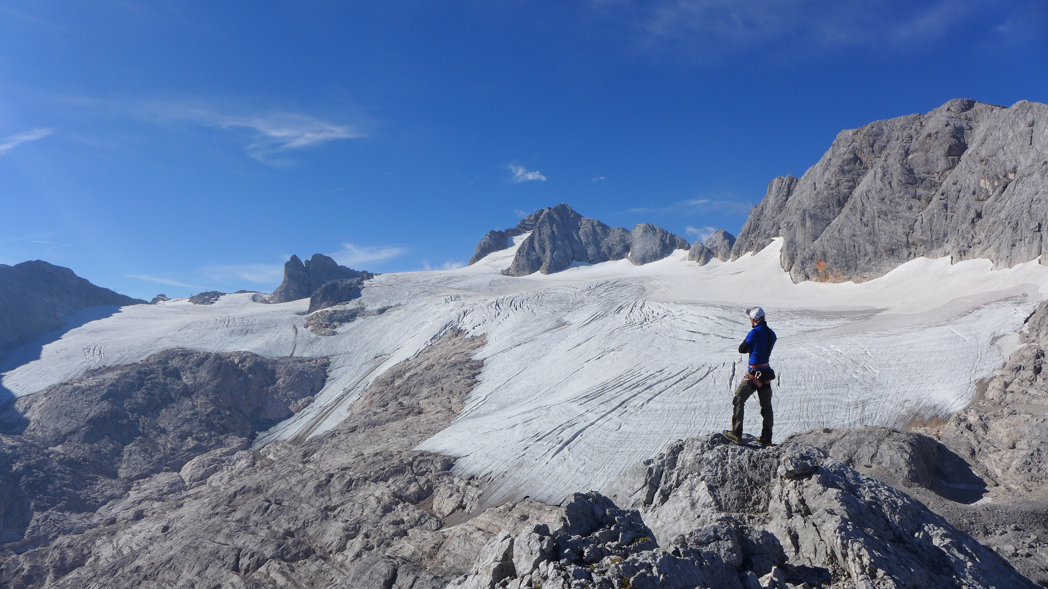
The Mullwitzkees is located in the Venediger Group in the core zone of the National Park Hohe Tauern. The upper part of the glacier (outer Mullwitzkees) is oriented to the south.The lower part of the glacier, especially the tongue, is oriented to West-South-West.