
soil gas flux
Type of resources
Available actions
Topics
Keywords
Contact for the resource
Provided by
Years
Formats
Representation types
-
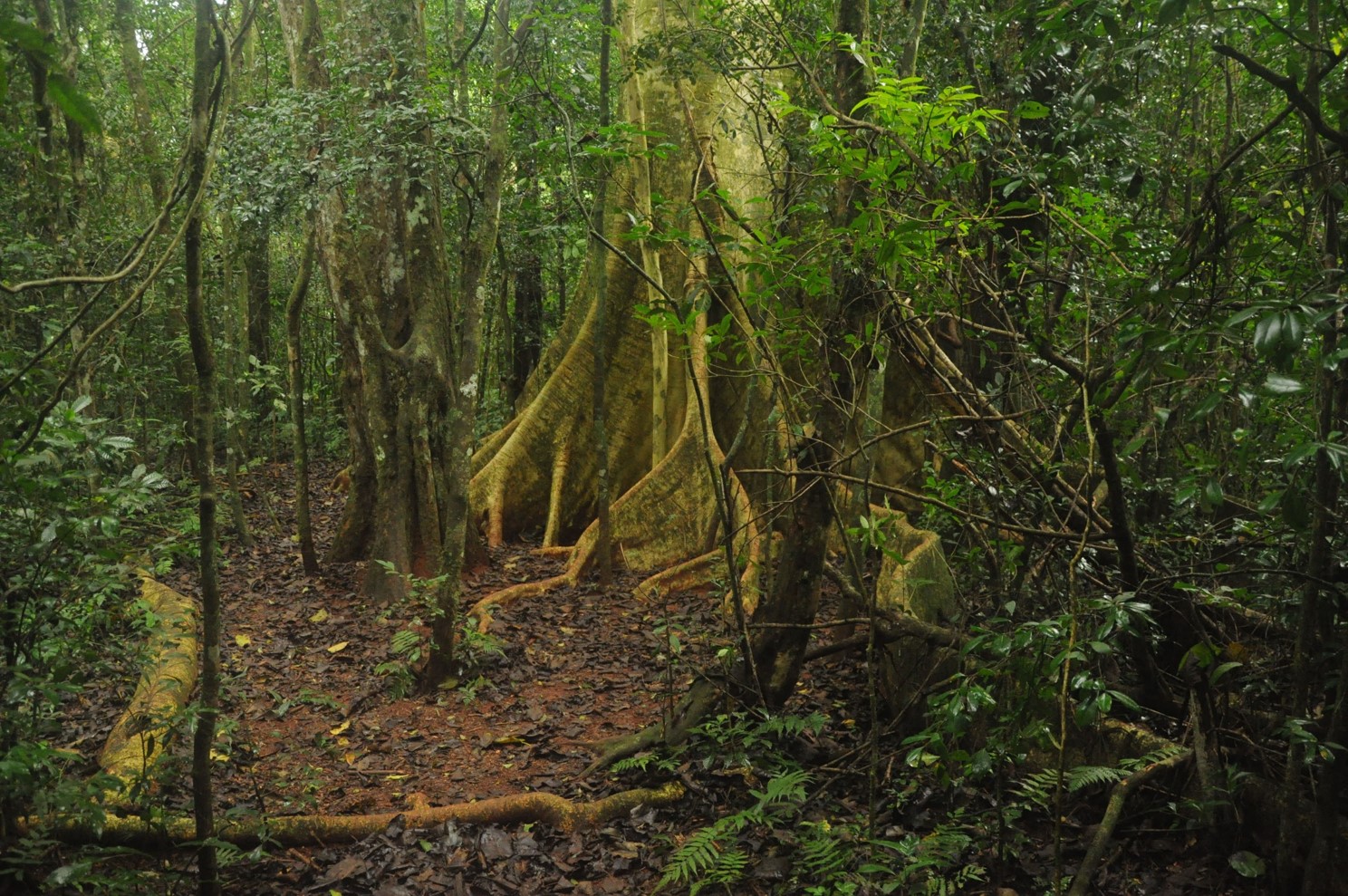
The site is composed by a set of Atlantic Forest fragments and restoration sites scattered in an agricultural landscape in north of Parana state, south Brazil. The forest in this region is a seasonal semi-deciduous form of Atlantic Forest, which undergone strong conversion rates from 1940 to 1980 and presently has only 8% forest cover, distributed in a myriad of small fragments. Forest fragmentation, fertilizer and pesticide leakage from agricultural fields and urbanization are the main regional drivers of environmental change. In each sub-site (forest fragment or restoration site) we are sampling flora, fauna and ecosystem attributes (forest biomass, litter fall, litter decomposition etc). The site is maintained by Londrina State University
-
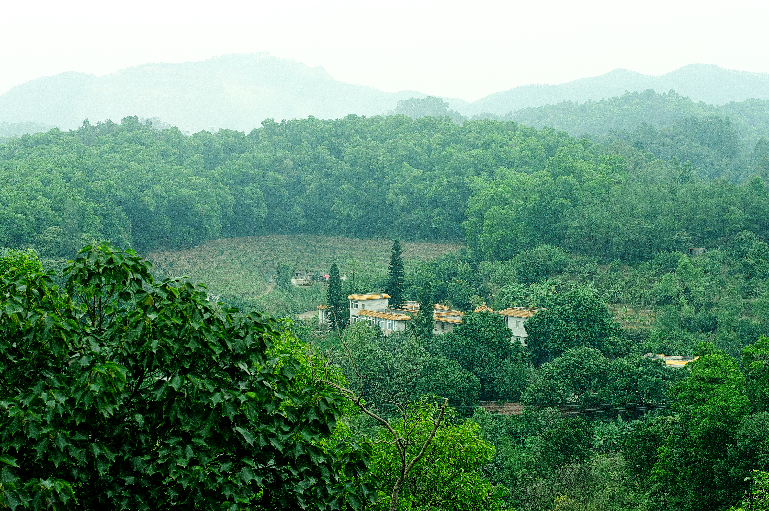
Heshan station (112 °54' E, 22 °41' N) is located in Heshan County, Guangdong Province, China. It is one of the core stations of the Chinese Ecological Research Network (CERN) of the Chinese Academy of Sciences (CAS.). The station was co-established by South China Institute of Botany (Renamed as South China Botanical Garden in 2002), CAS and Heshan Institute of Forest Science in 1984 based on the experience and knowledge of previous studies in a degraded costal ecosystem. Natural Conditions:The station is located in the central part of Guangdong Province with a typical climate of south subtropical monsoon. The soil is laterite. The mean annual temperature is 21.7 C, the mean rainfall is 1700 mm, and the mean evaporation is 1600 mm. The region is a hilly agricultural zone with 78.6% of hilly land, 17.1% of farming land and 4.3% of water body. The zonal vegetation is evergreen broad-leaved forest of typical subtropics. Research Areas:The research areas of the station include but not limited to the followings: 1) Study on canopy water flux of Acacia mangiun forest in the hilly lands of South China by applying sap flow technique; 2) Ecosystem carbon cycling; 3) Conservation genetics of cryptocarya chinensis population in lower subtropical fragmented forest; 4) N2O emission from main types of agricultural and forest lands in tropical and lower subtropical region of China; 5) comparative study on restoration progress between degraded tropical and subtropical ecosystems; 6) effects of landfills on soil biota and water quality; 7) impacts of forest composition on restoration progress; 8) mechanisms of adaptation of invasive species; 9) effects of girdling and defoliation on plant resource use efficiency and soil processes (root exudation, soil respiration and soil biota); 10) confounding effects of manure application on eucalyptus forest and on NEP (Net Ecosystem productivity); 11) nematodes as bio-indicators of different ecosystems.
-
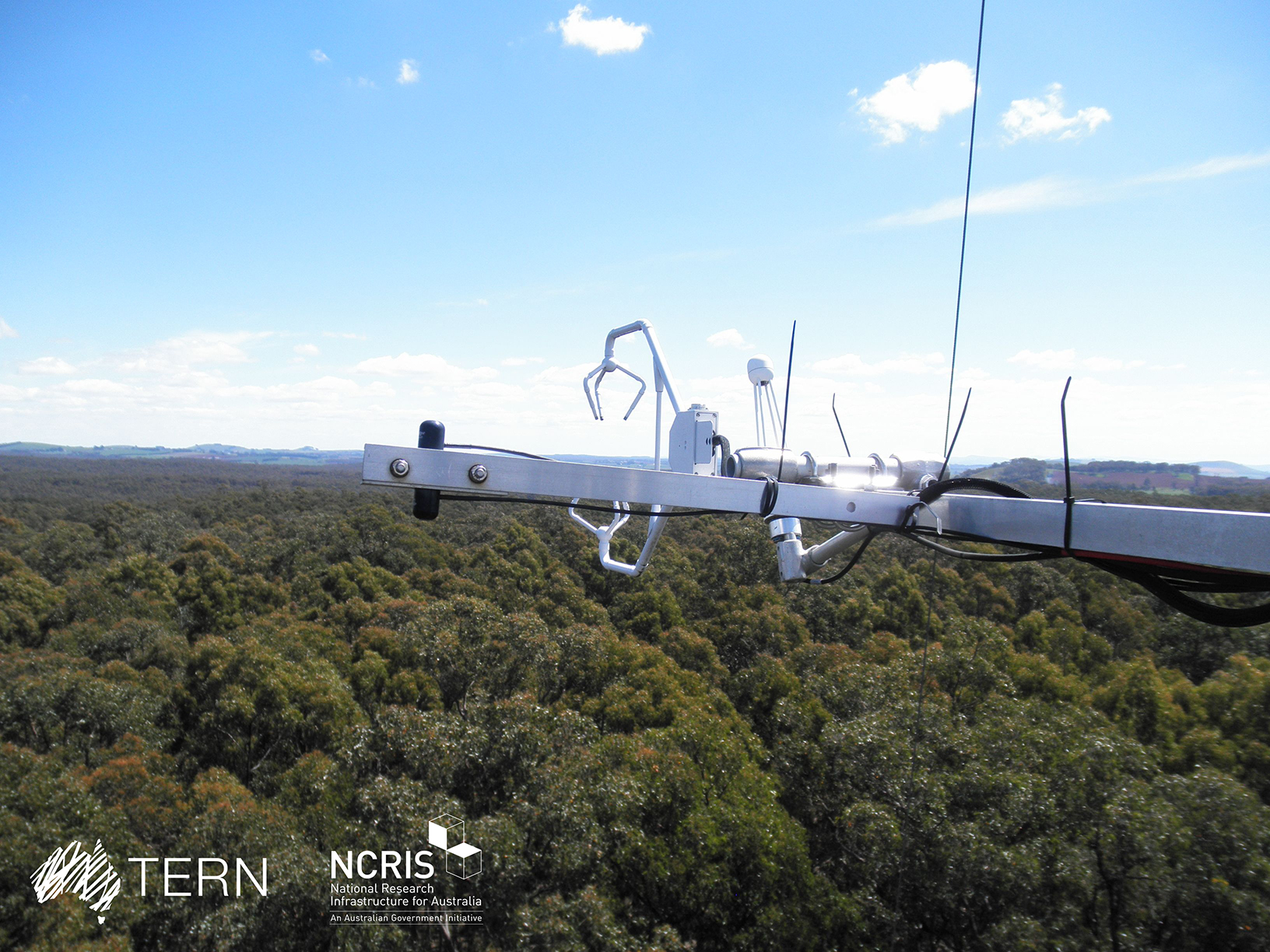
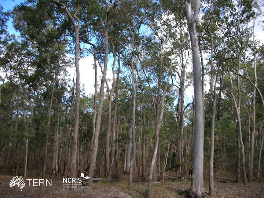
The Wombat Stringybark Eucalypt SuperSite is a member of the TERN Ecosystem Processes platform (https://www.tern.org.au/tern-observatory/tern-ecosystem-processes/), a field observatory within the Australian Terrestrial Ecosystem Network (TERN, http://www.tern.org.au/). The Wombat Stringybark Eucalypt SuperSite is located in the Wombat State Forest, Victoria, South Eastern Australia at an elevation of 713m. The site is a secondary re-growth forest that was last harvested in 1980. Dominant tree species are Eucalyptus obliqua (messmate stringybark), Eucalyptus radiata (narrow leaf peppermint) and Eucalyptus rubida (candlebark) with an average canopy height of 25 m. The understorey consists mainly of patchy grasses and the soil is a silty-clay overlying clay. The forest is managed by the Department of Environment, Land, Water and Planning and management includes selective harvesting and prescribed burning regimes. The climate of the study area is classified as cool-temperate to Mediterranean zone with cold and wet winters (May-Aug) and warm and dry summers (Dec-Feb). Key research objectives include: • What are the elements of structure, composition, functions and processes of the dry eucalypt forests of South Eastern Australia required for the sustainable management of these ecosystems? • What is the carbon sink/source strength of a dry sclerophyll forest and what is their contribution to Australia’s National Carbon Inventory? • What is the magnitude of emission and/or uptake of non-CO2 greenhouse gases, such as nitrous oxide and methane of dry eucalypt forest? • How will climate variability, drought or fire influence the ecosystem processes of dry eucalypt forest? The Dja Dja Wurrung peoples are the traditional owners at Wombat.
-
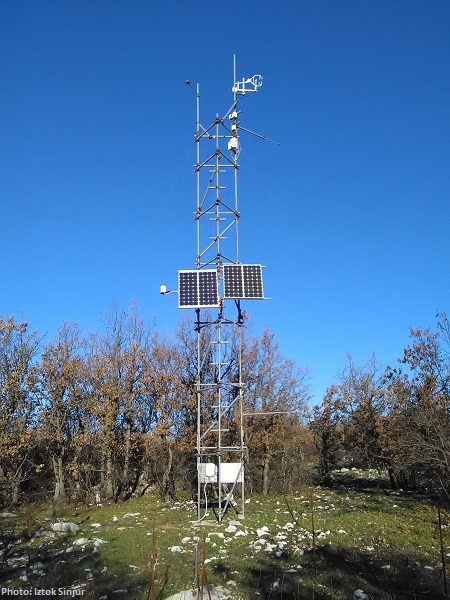
CARBON FLUXES IN TWO SUCCESSIONAL STAGES OF VEGETATION IN THE PODGORSKI KRAS. Research site represents karst grassland and different stages of secondary succession, occasionally affected from forest fires. It is located on karst plateau close to Podgorje village in the sub-mediterranean region of south-west Slovenia. The site is equipped with two Eddy Covariance towers which measure the carbon fluxes in two successional stages of vegetation. The area has undergone major human influences due to its position at the transition between the Mediterranean and central Europe. In fact, agricultural practices, such as overgrazing in the past centuries, led to pronounced destruction of the vegetation cover, causing severe soil erosion and resulting into a stony and bare landscape. However a succession is taking place and different vegetation types, ranging from grasslands to secondary oak forests, are now present. The bedrock is mainly composed of Paleocene and Eocene limestone. The chemical weathering known as karst phenomena led to the formation of Leptosols and Cambisols, which represent insoluble fractions of carbonates. As a result, the soil is superficial, with depths ranging from 0 cm to several decimeters in soil pockets between rocks. The organic matter represents about 12–15% of the topsoil. The climate is referred to as sub-mediterranean, with a mean annual temperature of 10.5 °C, a mean daily temperature of 1.8 °C and 19.9 °C in January and June respectively, and an average annual precipitation around 1370 mm. The growing season ranges from March or April to October.
-
The South East Queensland Peri-urban SuperSite is a member of the Australian SuperSite Network (SuperSites, http://www.supersites.net.au/), a facility within the Australian Terrestrial Ecosystem Network (TERN, http://www.tern.org.au/). The SEQ Peri-urban Supersite’s (SEQP) core infrastructure is located at the sub-tropical 50 ha Samford Ecological Research Facility (SERF) of the Queensland University of Technology in Brisbane (https://www.qut.edu.au/research/why-qut/infrastructure/samford-ecological-research-facility). SERF is located at the western extent of the Pine longitudinal transect north of Brisbane where the urban footprint is rapidly expanding. The transect extends from the upper reaches of the Pine River catchment through the Samford Valley to Central Moreton Bay. The traditional custodians of the Samford Valley are the Yugara nation. Clan relations may well have extended into and from the neighbouring Jinibara and Kabi Kabi. The Supersite focuses on the impact of urban development and low frequency, high flow (ephemeral) events on terrestrial biogeochemistry, biodiversity and downstream water quality. Rapid population growth in SEQ is expected to continue particularly in peri-urban areas. The development, transformation of land use and exploitation of resources associated with this population growth will intensify the pressure on catchment, aquatic and coastal environments, potentially leading to significant habitat fragmentation, water quality issues, biodiversity loss and loss of economic and amenity values. The vulnerability of SEQ’s high biodiversity ecosystems will be compounded by climate change in the region. Key research questions: • Can ecosystem services be maintained in an urbanising environment? • How do carbon and energy balances change under different land uses in transition from a natural dry sclerophyll forest to a peri-urban area? • What impact will Brisbane’s peri-urban development have on water quality and soil borne greenhouse gases (carbon dioxide, nitrous oxide and methane) and surrounding vegetation? • What are the long-term effects of urbanisation on remnant vegetation? • What impact does pasture composition and management have on greenhouse gas emissions? • How will changes in the climate, land-use (e.g. from rural to residential) affect soil nutrient balances and water leaving the catchment? • How can bio-acoustic monitoring be used for measuring ecosystem biodiversity and health?
-
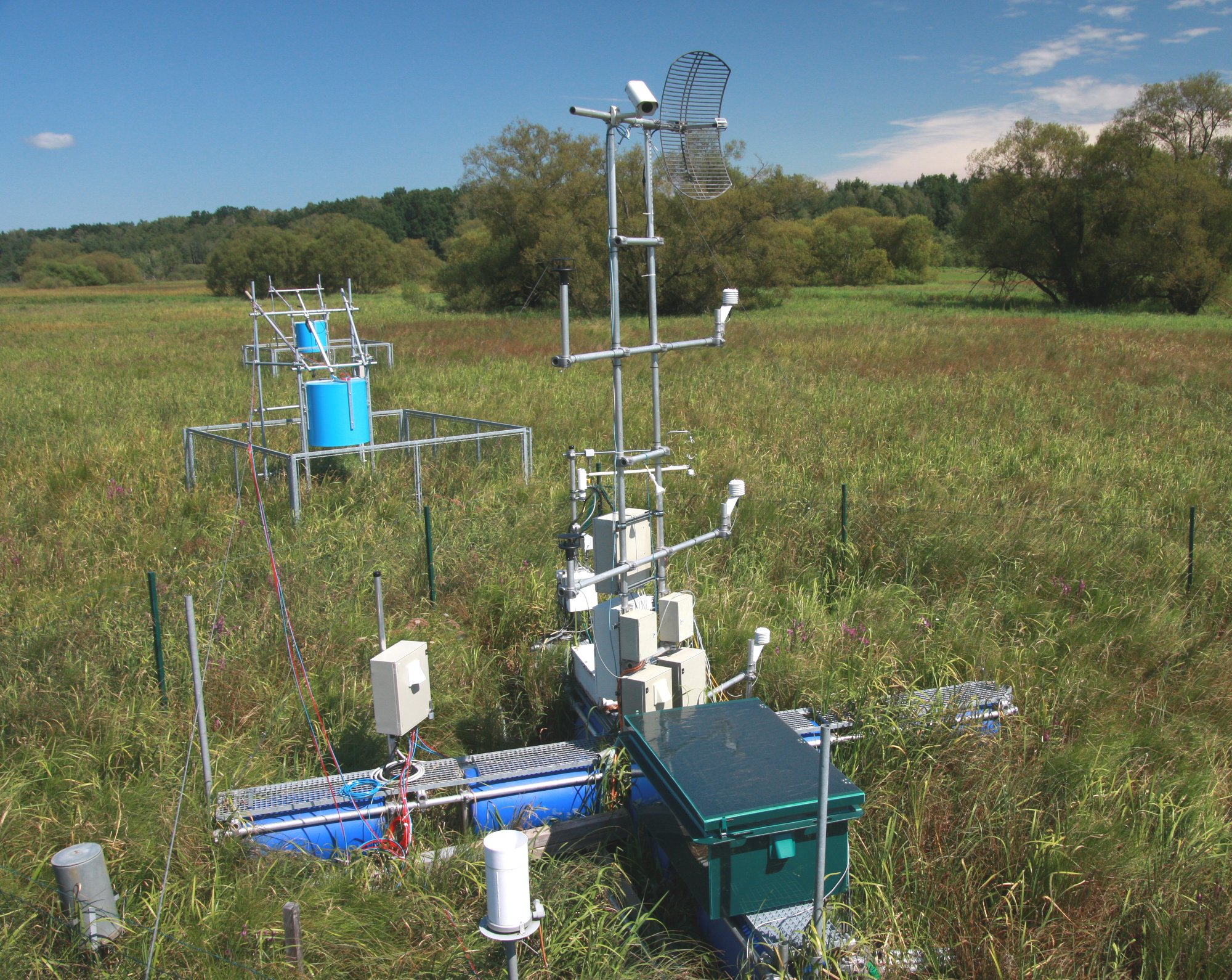
The Třeboň Wet Meadows is an LTER site of a 1 hectare area. It is a part of a wetland with the total area of 450 hectares situated in the inundation area of a large human-made reservoir (Rožmberk fishpond, 5 km2). The Wet Meadows are a predominantly herbaceous wetland with an up to several meters thick layer of organic sediment, which is superimposed on quaternary alluvial sands and clays. The vegetation cover is formed mainly by tall sedges (Carex acuta, C. vesicaria) and reed Canarygrass (Phalaris arundinacea). During the last 50 years, after cessation of mowing, a distinct stand structure of hummocks and hollows has developed. The hummocks are formed by tussocks of Carex acuta. On the site, wide water level fluctuations are recorded in some years. The relatively regular spring floods and irregular summer floods occur as a consequence of snow melting and summer rains in the catchment area, respectively. Extreme floods occurred in the summer of 2002 and both spring and summer of 2006, when the water level culminated at 2 m above the soil surface. The most frequently recorded position of the water level is at about −0.1 m. From 1977 to 2006, meteorological measurements were executed in a meteorological screen. Starting from 2006, the measurements have been executed with electronic sensors connected to data-loggers. Since that time, the site has been equipped for measuring carbon exchange and fluxes of CO2 and H2O (eddy covariance system, Licor). Since the spring of 2011, the site has been equipped for measuring methane and CO2 emissions from the sedges (automatic static flow chamber with a laser gas analyzer, LGR).The Wet Meadows are included in the integrated carbon observation system (ICOS) as a wetland ecosystem station.
-
Pianosa Island (Long. 10° 04' 44” E and Lat. 42° 35' 07” N) is the fifth, by extension, of the seven islands of the Tuscan Archipelago National Park with a total area of 10.2 km2 and a coastal perimeter of approximately 20 km. The island is almost completely flat, with some small undulations. The highest elevation is 29 m above sea level (a.s.l.), while the average is about 18 m a.s.l. The climate of Pianosa is influenced by its flat morphology that prevents the condensation of moist air, resulting in a mean annual rainfall considerably lower than on the other islands of the Tuscan Archipelago; furthermore, due to the high permeability of the soils, the rain is quickly drained. On the basis of an historical meteorological dataset (1951-2009), mean air temperature is 15.8 °C and mean annual rainfall is 497 mm, ranging between a minimum of 176 mm (1999) and a maximum of 716.2 mm (1984). A clear seasonal precipitation pattern shows a maximum from October to December followed by a decrease with a minimum value in July. The first historical record of Pianosa island dates back to the Roman age, when the Emperor Ottaviano, in the 6-7 A.C., forced the grandson Agrippa Postumo to live on Pianosa island. Following the decadence of the Roman Empire, during the periods of Barbarians’ invasions, the island was abandoned. The name of Pianosa island newly appeared in some documents of the Repubbliche Marinare of Pisa and Genova (XII and XIII century) that reported the remarkable strategic position of the island. The 27th August 1802, Napoleone Bonaparte established that the islands of Elba, Capraia, Pianosa, Palmaiola and Montecristo were united to the territory of the French Republic. Bonaparte visited Pianosa twice and found it the most interesting of the other islands, appreciating its richness of vegetation and animals. In 1858 Pianosa became an Agriculture Penal Colony, where the prisoners were forced to work in the fields. During the ’70s the jail of Pianosa became a maximum security penitentiary. Only in the ’80s, representatives of the Government and members of the civil society started to propose to close the prison and to return Pianosa to the competent civil authority. In view of this, the number of the prisoners was drastically reduced and, consequently, several agriculture activities progressively stopped. In the 1997 the territory of Pianosa was formally included in the National Park of the Tuscan Archipelago and since than it is a site for natural conservation. In 1998 the penitentiary was completely dismissed
-
The 'West Polesie' Biosphere Reserve has been created in 2002. Reserve area (140 000 ha) covers almost whole Łęczna-Włodawa Lake District as well as its near vicinity. It is situated about 40 km north-east of Lublin adjacent to Ukraine’s Shatski Biosphere Reserve. West Polesie includes Poleski National Park, three Landscape Parks: Sobiborski, Łęczna Lake District and Chełmski. The most important protected area in the Reserve is Poleski National Park, with natural resources of lakes (e.g. Łukie, Moszne, Długie) and peatbogs (Orłowskie, Durne Bagno, Bagno Bubnów). Many kinds of endangered species of fauna and flora can be found in the West Polesie area. Villages in this rural area show many examples of traditional wooden architecture and still maintain a cultural and folklore life. The 'West Polesie' Biosphere Reserve is located in the eastern part of Lubelskie voivodship and consist 25 administrative units (3 towns and 22 communes).
-
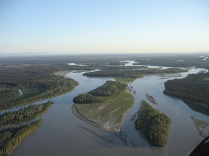
The Bonanza Creek Experimental Forest (BCEF), located approximately 20 km southwest of Fairbanks, Alaska, was established in 1963 with about 3360 ha (8,300 acres) of upland, interior Alaska boreal forest. In 1969, the experimental forest was enlarged to 5053 ha (12,487 acres) to include representative floodplain forests along the Tanana River. The Forest is within the Tanana Valley State Forest, a unit managed by the Division of Forestry, State of Alaska. In 1987 the Bonanza Creek Long-Term Ecological Research program was established, with BCEF as its primary research site.
-
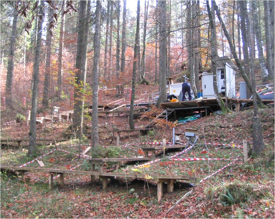
Norway Spruce-Fir-Red Beech Forest on Limestone The experimental site Mühleggerköpfl is located on the northern edge of the Alps and receives air pollutants that are transported over long distances, by predominant westerly winds; local emissions from rural settlements are low. The LTER site has an area of 20 hectares. It is a privately owned mature montane forest rich in Norway spruce in the Northern Limestone Alps at 920 m a.s.l. on a north–north-east facing slope of a mountain (47° 34’ 50” N; 11° 38’ 21” E). The site on an isolated calcareous outcrop in the valley of Achenbach represents a watershedsmall catchment. Routinely measured parameters over the years have included climate (air temperature, precipitation, and air humidity), soil temperature, soil water content, soil solution chemistry, nutrient content of Norway spruce needles, air quality, deposition of N, and surface runoff. The climate is cool and mesic with maximum precipitation in summer and a snow-free period from April/May to November/December. The mean annual air temperature and precipitation from on-site measurements are 6.8°C and 1580 mm, respectively. The annual variability of the precipitation is small. Moist conditions are also evident from the high relative air humidity.