
soil heat flux
Type of resources
Available actions
Topics
Keywords
Contact for the resource
Provided by
Years
Formats
Representation types
-
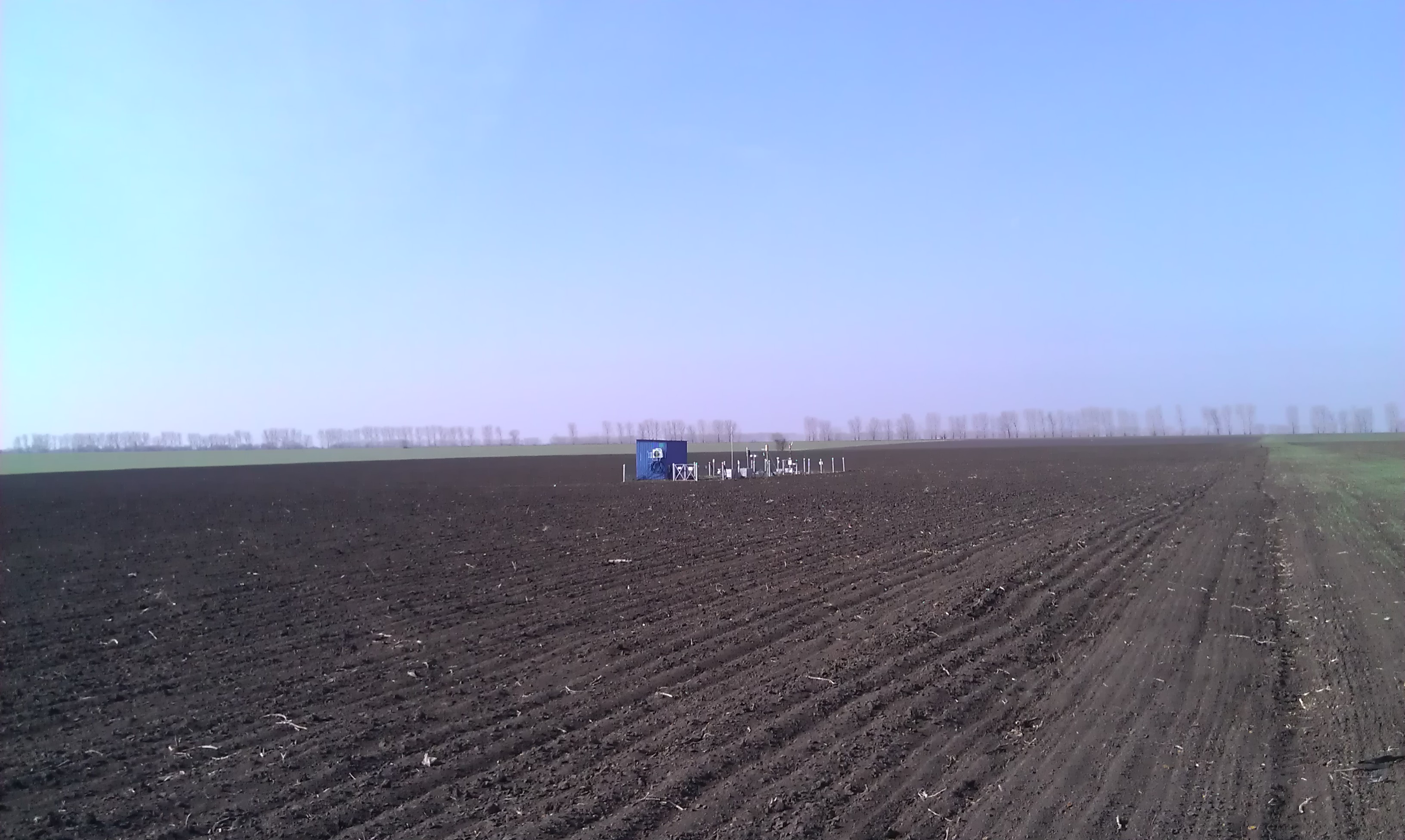
Research Monitoring Station "Petrodolinskoye" (PTR) of the Regional Centre for Integrated Environmental Monitoring and Ecological Studies (RCIEM) of Odessa National I. I. Mechnikov University (ONU) is located on an actively managed arable land. The site is situated 8 km from the Dniester River, which enters the Black Sea (29 km from the study site). The station is located near the village “Mirnoe” (46º27'22.12''N; 30º20'9.94''E), 27 km southeast of Odessa and was established in 2006 within the framework of the EU FP6 NitroEurope IP (Medinets et al., 2014). The arable field study site is 10 ha in size with a flat topography at an elevation of 66 m above sea level. The soil is a black soil (FAO definition: Chernozems Vermi-Calcic, CH vec), and representative for the south of Ukraine (Medinets et al., 2014b, 2016). The climate is temperate continental, with an annual average air temperature of 10.5 °С (period of 2000-2014), an annual minimum mean of 8.4 °С and an annual maximum mean of 12.5 °С. Total average annual precipitation is 432 mm. The atmospheric total N (TN) deposition rate is moderate at ca. 11.4 kg N ha-1 y-1 with significant organic N contribution of circa 67% (Medinets et al., 2016). Crop rotation and management. The study site has been under active agricultural management for more than 200 years, although a detailed history of the agricultural management is unknown. Before autumn 2006 the area was managed by a collective farm (‘kolkhoz’). The study field, 10 ha in size, was leased in autumn 2006 from the Association of Agricultural Enterprises “Granit”. The crop rotation started with wheat in 2006, in the period 2007 – 2014 was onions (2007), tomatoes (2008), barley (2009) and winter wheat (2009/2010) followed by winter onion (2010/2011), carrot (2011), tomato (2012), red beetroot (2013) and onion (2014) followed by winter wheat. This rotation is typical for this region. Crops (except cereals) were grown with drip irrigation (installed in 5-10 cm depth), with fertilizer applied together with the irrigation (fertigation). E.g., during the study period of 2012-2014 the field was fertilized with mineral NPK fertilizers (see Medinets et al., 2016). To prevent plant diseases and to suppress weeds, pesticides and herbicides were applied to all crops following farmers practice. The following tillage methods were used: deep ploughing (40 cm depths), disking (10 cm depth), harrowing (10 cm depth), cultivation (10 cm depth), inter-row cultivation (5 cm depth); the soil was also disturbed under installation/ removing of irrigation tubes (see Medinets et al., 2016).
-
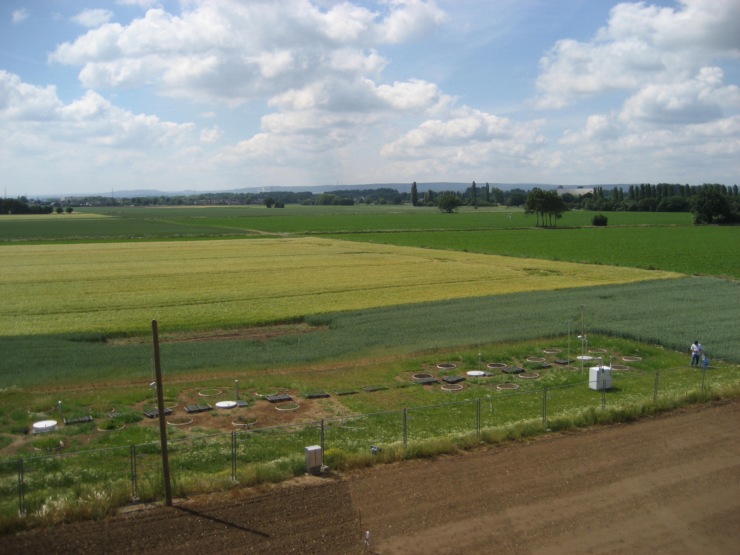
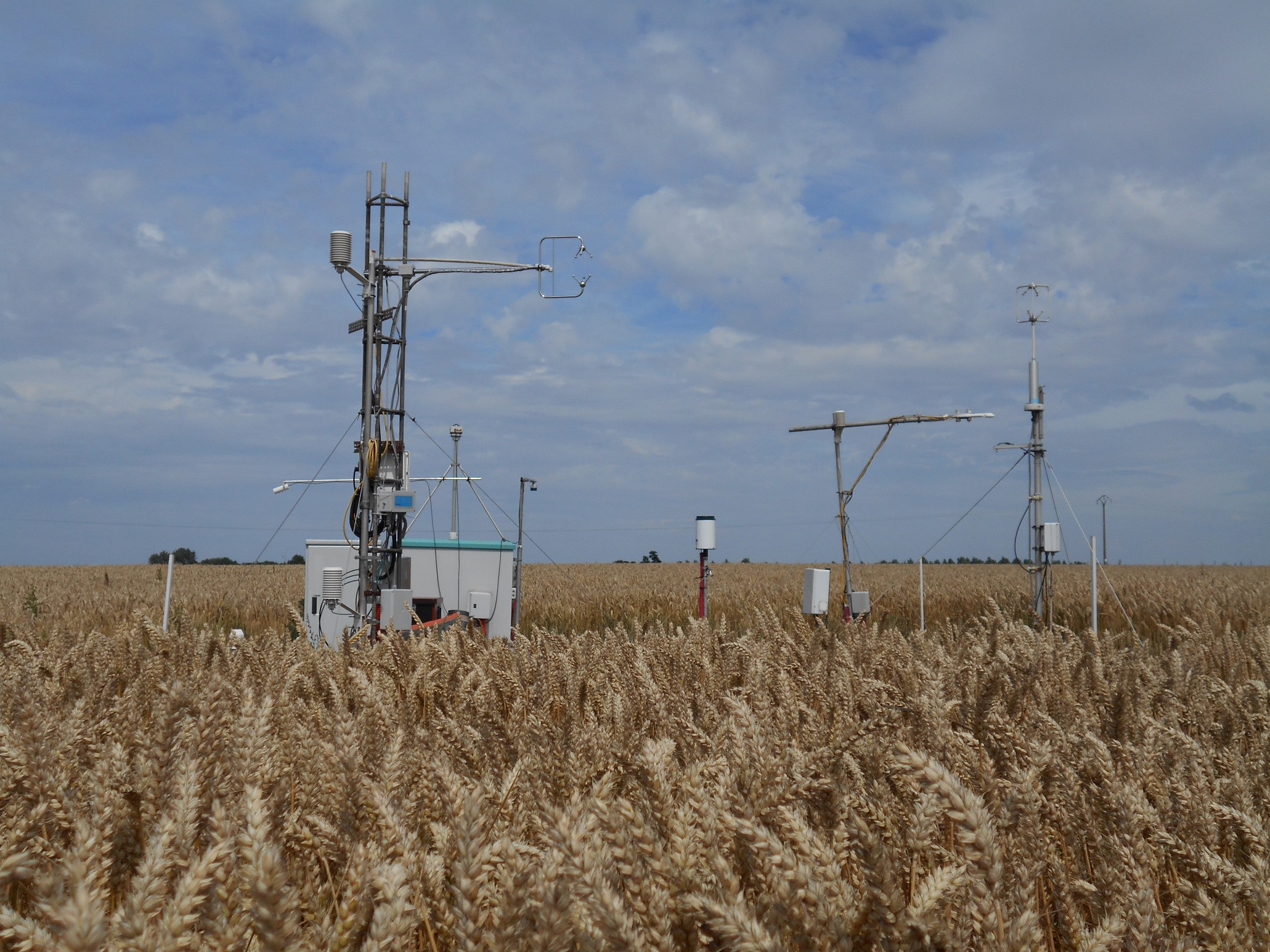
The Selhausen site represents the heterogeneous agricultural rural area of the lower Rhine valley. The climate is temperate maritime with a mean annual temperature of 10°C and annual precipitation of 700 mm for the period from 1961 to 2014 (meteorological tower, Forschungszentrum Jülich). The most important crops in the region of Selhausen are sugar beet (beta vulgaris), winter wheat (triticumavesticum), winter barley (hordeum vulgare), maize (zea mays) and rape seed (brassica napus). Only parts of the region are managed as grasslands. The underlying Quaternary sediments are mostly fluvial deposits covered with loess. Major soil types are luvisols and gleyed cambisols, partly with large contents of gravel. The land surface is generally flat with slopes up to 4° in the area of a former channel of the Rur River system. From 2007 to 2010 a first long-term eddy covariance study was conducted within the Selhausen region (measurements can be found at the European fluxes database cluster, ID: DE-Seh). In spring 2011 a new station (50.865°N, 6.447°E, 203m a.s.l.) was equipped with a CSAT3 sonic anemometer and LI7500 gas analyzer. Besides flux measurements and typical climate parameters (radiation, air temperature, air humidity, soil moisture, soil temperature etc.), also the phenological development of the crops and farming activities were recorded. The station fits now the standards of a Level-1 site for the European project ICOS (Integrated Carbon Observation System). As a pan-European long-term research infrastructure ICOS aims at providing harmonized and high-precision scientific data on carbon cycle and greenhouse gas budget and perturbations.
-
The NEON site at the Oak Ridge National Laboratory (ORNL) is a 138.1-km^2 core terrestrial field site located in the Cumberland Plateau within Anderson and Roane Counties, TN. It is encompassed within NEON's Appalachians and Cumberland Plateau Domain 7, which includes the worlds longest expanse of hardwood-forested plateau. This domain is home to some of North America's greatest diversity of fish, mollusk, and wildflower species. ORNL is managed by a combination of the Department of Energy (DOE) and Tennessee Wildlife Resources Agency (TWRA). The Domain hosts four other NEON field sites, two aquatic and two terrestrial, three of which are located in Tennessee. Remote sensing surveys of this field site collect lidar, spectrometer and high-resolution RGB camera data. The flux/meteorological tower at this site is 127 with 6 measurement levels. The tower top extends above the vegetation canopy to allow sensors mounted at the top and along the tower to capture the full profile of atmospheric conditions from the top of the vegetation canopy to the ground. The tower collects physical and chemical properties of atmosphere-related processes, such as humidity, wind, and net ecosystem gas exchange. Precipitation data are collected by a tipping bucket at the top of the tower and a series of throughfalls located in the soil array. This site has five soil plots placed in an array within the airshed of the flux tower. Field ecologists collect the following types of observational data at this site: Terrestrial organisms (birds, ground beetles, mosquitoes, plants, small mammals, soil microbes, ticks), Biogeochemical data, and soil data. Total data products planned for this site: 119
-
The Kellogg Biological Station (KBS) is located in southwest Michigan in the eastern portion of the U.S. cornbelt, 50 km east of Lake Michigan in the SW corner of the state (42° 24′ N, 85° 24′ W, elevation 288 m). Annual rainfall at KBS averages 1,005 mm/y with about half falling as snow; potential evapotranspiration (PET) exceeds precipitation for about 4 months of the year. Mean annual temperature is 10.1 °C. KBS is 1600 ha of cropping systems, successional communities, and small lakes. Surrounding KBS is a diverse, rural-to-semirural landscape typical of the U.S. Great Lakes and upper Midwest regions. The diversity of land use, soil and vegetation types, and aquatic habitats within a 50-km radius of the Station is high. Most of southwest Michigan is on the pitted outwash plain of the morainic system left by the last retreat of the Wisconsin glaciation, circa 12,000 years ago. Soils in the area developed on glacial till, and include well- and poorly-drained alfisols, mollisols, and entisols. Most regional soils are sandy loam and silty clay loam of moderate fertility, principal Station soils are Typic Hapludalfs. Land use around KBS ranges from urban (Kalamazoo, with a metropolitan population of 180,000, is 20 km south of the Station) to rural; vegetation ranges from cultivated and early successional old fields to older growth oak-hickory and beech-maple forests; and aquatic habitats include more than 200 bodies of water of different morphometries, alkalinities, and degrees of eutrophication within 50 km. Cropping systems in the area are typical of the U.S. cornbelt — mainly corn/soybean rotations with wheat of varying importance, and alfalfa an important forage crop. KBS yields are typical of non-irrigated yields elsewhere in the North Central Region. KBS LTER research is carried out in a variety of experimental systems. The most important of these is the Main Cropping System Experiment (MCSE), which was started in 1989 and consists of 11 different cropping systems or successional plant communities, ranging from annual corn-soybean-wheat rotations to late-successional deciduous forest. All communities are replicated within the landscape.
-
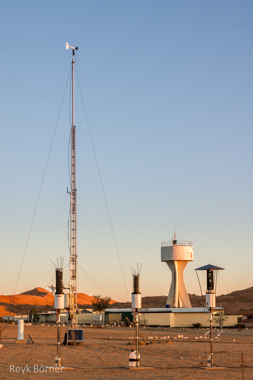
Gobabeb is a Research Centre with accommodation, conference, laboratory and teaching facilities in Namibia's Namib-Naukluft National Park, about 65km from the coast on the northern bank of the ephemeral Kuiseb River. It is located at a point where three main habitats meet (ephemeral river, gravel plain and the Namib erg) and lies within the inland edge of the fog zone. It is the designated monitoring and research centre for the Namib Sand Sea World Heritage Site.
-
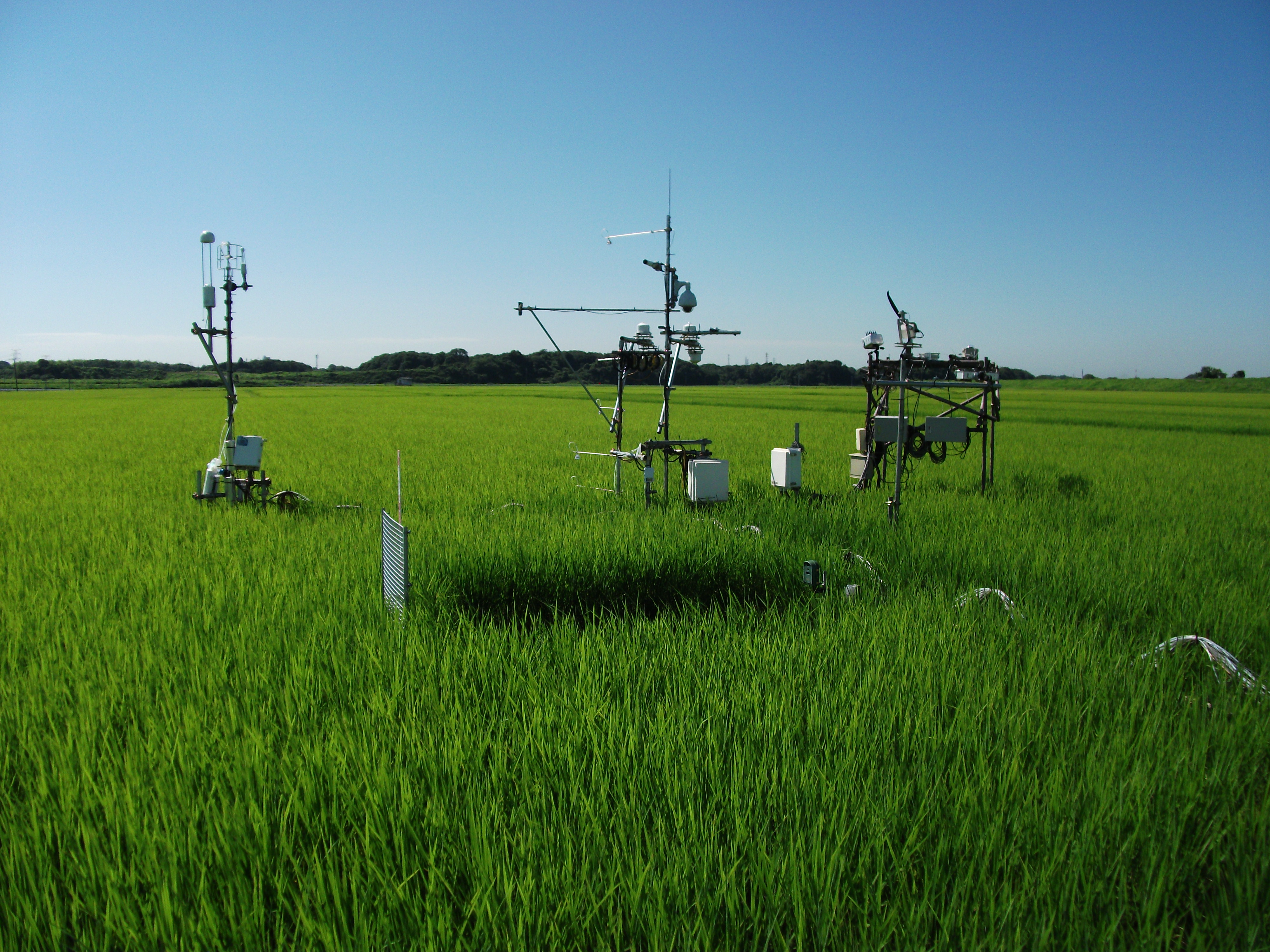
The Mase rice paddy site is a flux station in the AsiaFlux micrometeorological tower network. Located in a regularly cultivated rice paddy area of the Kanto plain in Japan, the site was established in 1999. The initial motivation was to quantify the energy and carbon balance in the rice paddy (ca, 54 a) where the tower was situated. Because of the accessibility and line-power availability, the site has involved many researchers and students from universities and institutes, broadening its target to studies on satellite and field remote sensing, ecosystem modelling, and nutrient cycling.
-
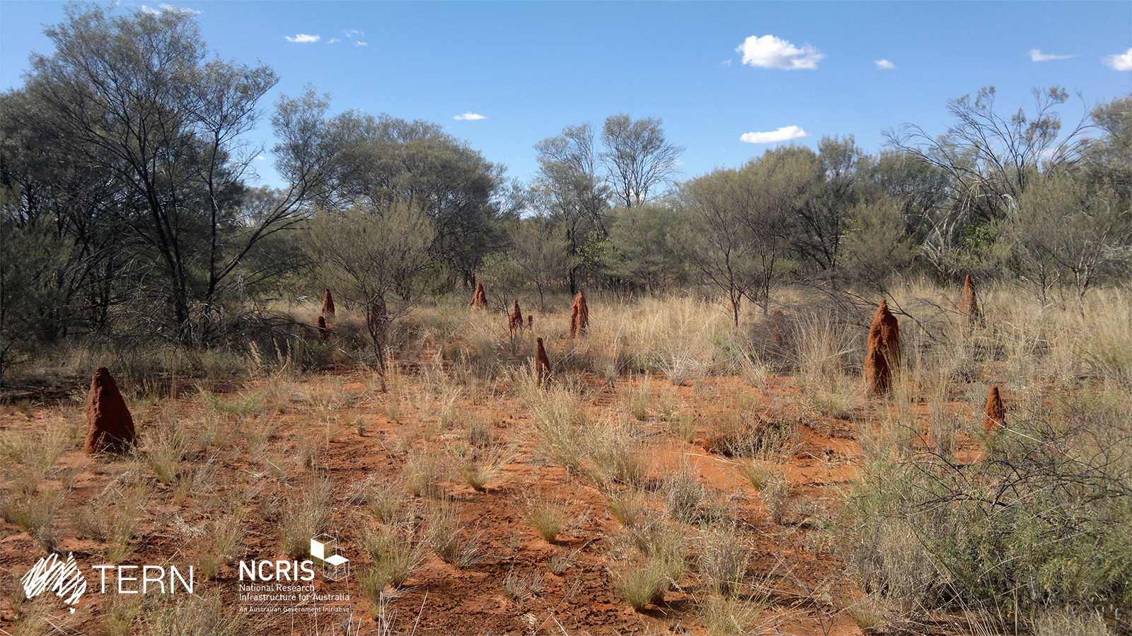
The Alice Mulga SuperSite is a part of the Australian Terrestrial Ecosystem Network (TERN, http://www.tern.org), which provides environmental research infrastructure for understanding how and why ecosystem change occurs (https://www.tern.org.au/tern-observatory/tern-ecosystem-processes/). The Alice Mulga SuperSite is located on Pine Hill Cattle Station approximately 200 km north of Alice Springs, Northern Territory. It lies in the expansive arid and semi-arid portion of mainland Australia that receives less than 500 mm of annual rainfall. The site includes Mulga woodland, hummock grassland, and river red gum forest. The SuperSite Core 1 ha is located in a dense Mulga woodland (cover 70–80%). The SuperSite has a second TERN OzFlux tower at Ti Tree East where TERN Surveillance Plots are also located in a mosaic of hummock grassland/Corymbia savanna with patches of Mulga/tussock grass. A third study location in the SuperSite is a river red gum forest along the Woodforde river where where several hydrological and plant ecophysiological studies have been performed. The traditional owners of these lands are the Anmatyerre Nation.
-
The site is a cropland with a 4-year rotation. Fluxes of CO2 and water vapour are measured by an eddy covariance system. Research activities are carried out by the university of Liège (GxABT).
-
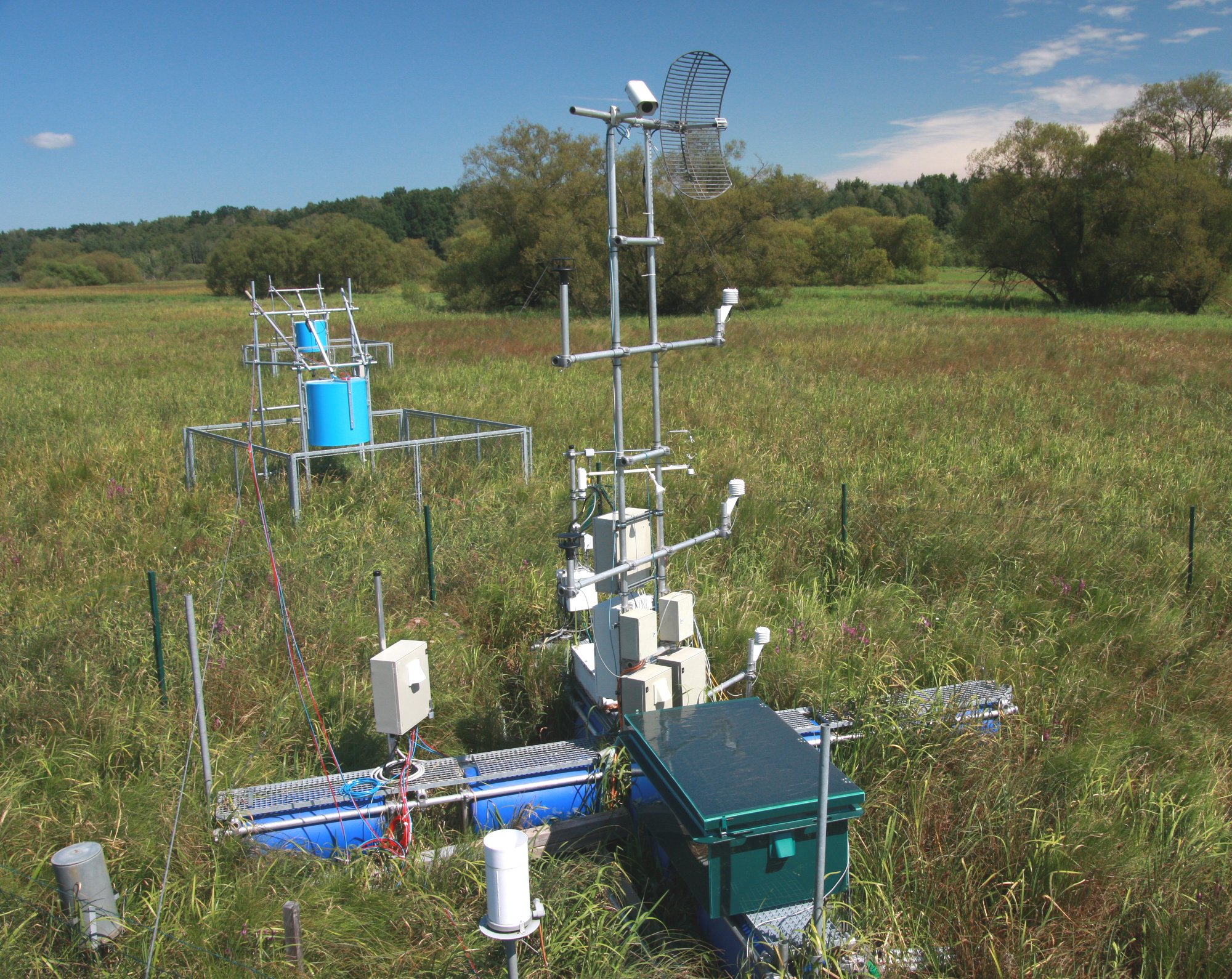
The Třeboň Wet Meadows is an LTER site of a 1 hectare area. It is a part of a wetland with the total area of 450 hectares situated in the inundation area of a large human-made reservoir (Rožmberk fishpond, 5 km2). The Wet Meadows are a predominantly herbaceous wetland with an up to several meters thick layer of organic sediment, which is superimposed on quaternary alluvial sands and clays. The vegetation cover is formed mainly by tall sedges (Carex acuta, C. vesicaria) and reed Canarygrass (Phalaris arundinacea). During the last 50 years, after cessation of mowing, a distinct stand structure of hummocks and hollows has developed. The hummocks are formed by tussocks of Carex acuta. On the site, wide water level fluctuations are recorded in some years. The relatively regular spring floods and irregular summer floods occur as a consequence of snow melting and summer rains in the catchment area, respectively. Extreme floods occurred in the summer of 2002 and both spring and summer of 2006, when the water level culminated at 2 m above the soil surface. The most frequently recorded position of the water level is at about −0.1 m. From 1977 to 2006, meteorological measurements were executed in a meteorological screen. Starting from 2006, the measurements have been executed with electronic sensors connected to data-loggers. Since that time, the site has been equipped for measuring carbon exchange and fluxes of CO2 and H2O (eddy covariance system, Licor). Since the spring of 2011, the site has been equipped for measuring methane and CO2 emissions from the sedges (automatic static flow chamber with a laser gas analyzer, LGR).The Wet Meadows are included in the integrated carbon observation system (ICOS) as a wetland ecosystem station.
-
Pianosa Island (Long. 10° 04' 44” E and Lat. 42° 35' 07” N) is the fifth, by extension, of the seven islands of the Tuscan Archipelago National Park with a total area of 10.2 km2 and a coastal perimeter of approximately 20 km. The island is almost completely flat, with some small undulations. The highest elevation is 29 m above sea level (a.s.l.), while the average is about 18 m a.s.l. The climate of Pianosa is influenced by its flat morphology that prevents the condensation of moist air, resulting in a mean annual rainfall considerably lower than on the other islands of the Tuscan Archipelago; furthermore, due to the high permeability of the soils, the rain is quickly drained. On the basis of an historical meteorological dataset (1951-2009), mean air temperature is 15.8 °C and mean annual rainfall is 497 mm, ranging between a minimum of 176 mm (1999) and a maximum of 716.2 mm (1984). A clear seasonal precipitation pattern shows a maximum from October to December followed by a decrease with a minimum value in July. The first historical record of Pianosa island dates back to the Roman age, when the Emperor Ottaviano, in the 6-7 A.C., forced the grandson Agrippa Postumo to live on Pianosa island. Following the decadence of the Roman Empire, during the periods of Barbarians’ invasions, the island was abandoned. The name of Pianosa island newly appeared in some documents of the Repubbliche Marinare of Pisa and Genova (XII and XIII century) that reported the remarkable strategic position of the island. The 27th August 1802, Napoleone Bonaparte established that the islands of Elba, Capraia, Pianosa, Palmaiola and Montecristo were united to the territory of the French Republic. Bonaparte visited Pianosa twice and found it the most interesting of the other islands, appreciating its richness of vegetation and animals. In 1858 Pianosa became an Agriculture Penal Colony, where the prisoners were forced to work in the fields. During the ’70s the jail of Pianosa became a maximum security penitentiary. Only in the ’80s, representatives of the Government and members of the civil society started to propose to close the prison and to return Pianosa to the competent civil authority. In view of this, the number of the prisoners was drastically reduced and, consequently, several agriculture activities progressively stopped. In the 1997 the territory of Pianosa was formally included in the National Park of the Tuscan Archipelago and since than it is a site for natural conservation. In 1998 the penitentiary was completely dismissed