
soil immobile water content
Type of resources
Available actions
Topics
Keywords
Contact for the resource
Provided by
Years
Formats
Representation types
-

Dong Cao is a small agricultural catchment (47 ha) of northern Vietnam, located at 70 km from Hanoi, in a sloping land environment. The objective is to monitor the impacts of land use changes (from cassava to fodder and tree plantations) and possible climate changes upon hydrological and sedimentary fluxes and budgets. The catchment has an elevation of 125 m to 485 m and slopes range from 15 to 120%. Monitoring devices include an automatic meteorological station, and weirs to monitor discharge, suspended sediment and bedload. More information is available on https://mtropics.obs-mip.fr/ and in the following paper: Valentin, C., et al., 2008. Runoff and sediment losses from 27 upland catchments in Southeast Asia: Impact of rapid land use changes and conservation practices. Agric. Ecosyst. Environ. 128, 225–238. https://doi.org/10.1016/j.agee.2008.06.004
-
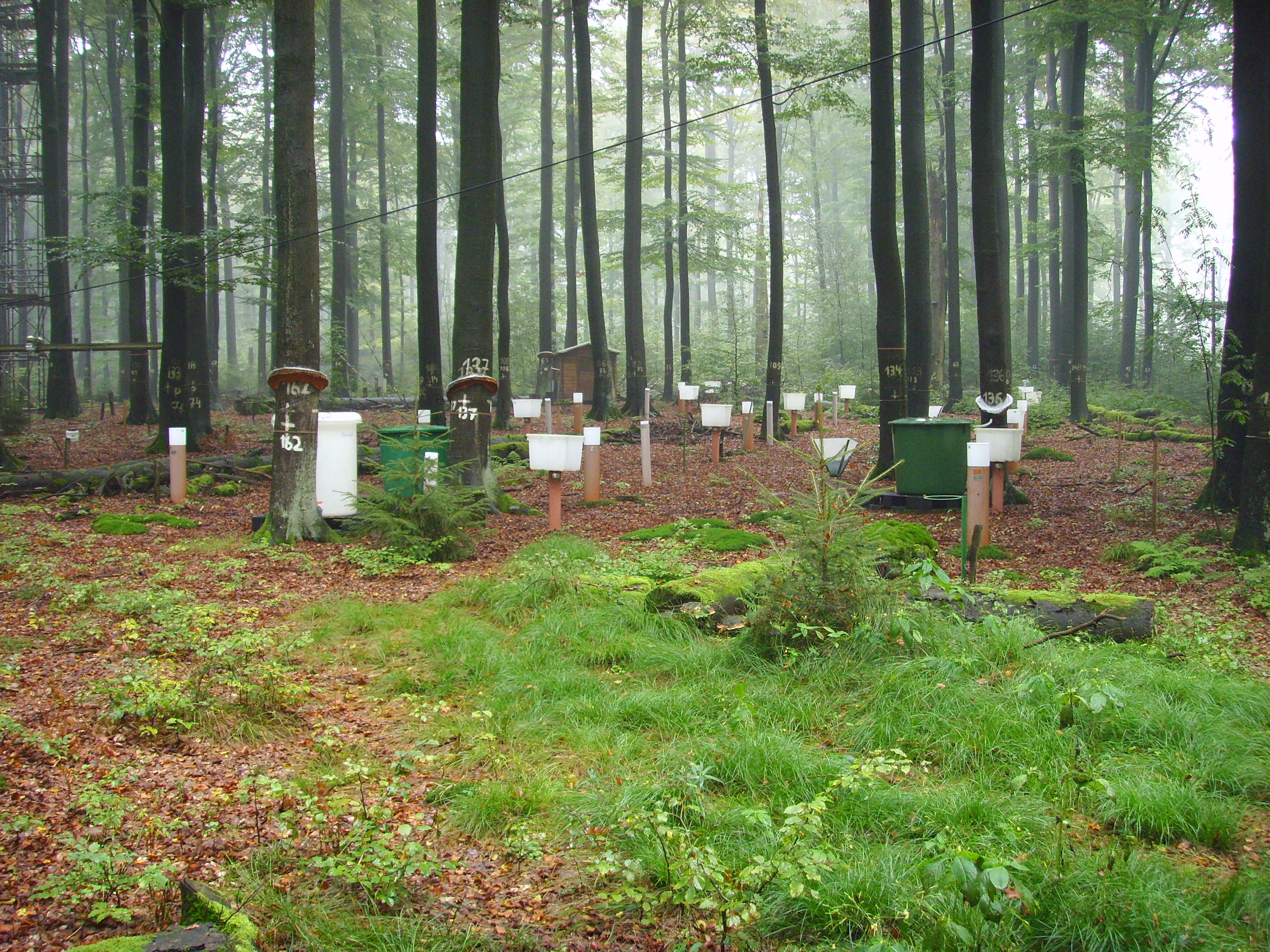
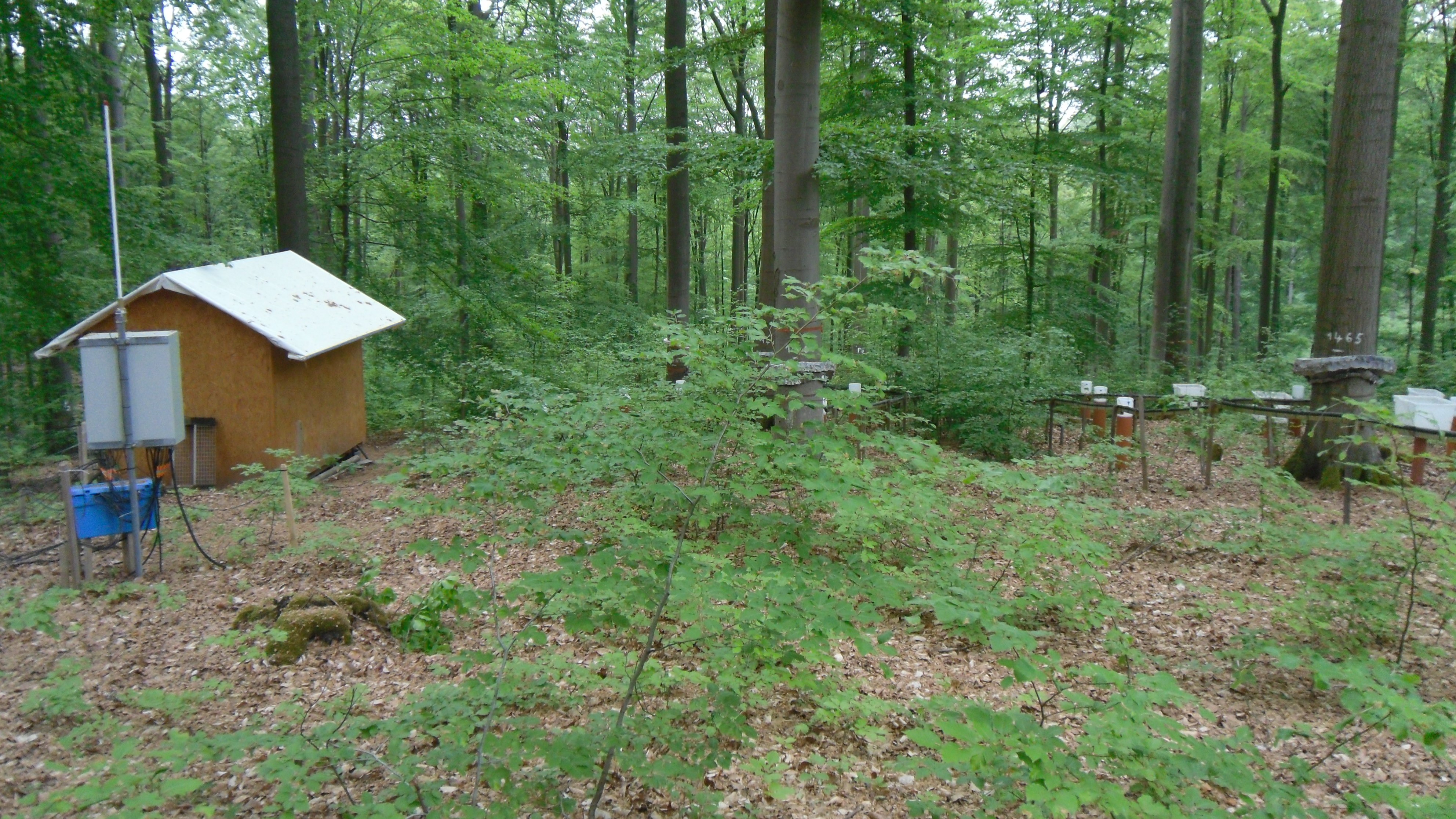
Solling Experimental Forest
-
Krofdorf Forest hydrological research area 4 catchments: A1 (9 ha), A2 (20 ha), B1 (11 ha), B2 (14 ha)
-
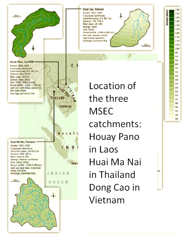
Houay Pano is a small agricultural catchment (60 ha) of northern Lao PDR, 10 km from the UNESCO world heritage city of Luang Phrabang, in a sloping land environment monitored since 1998. The objective is to monitor the impact of land use changes from annual crops (upland rice, Job’s tear and maize, cultivated with slash and burn system) to perennial (teak trees), and of climate changes upon hydrological and sedimentary fluxes and budgets, along with water quality (including microbial contamination). The mean slope is 48%. Alfisol, Ultisol, Entisol developed on shale and shist. Monitoring devices include an automatic meteorological station, weirs to monitor discharge from nested catchments, suspended sediment, and bedload, piezometers, and electrical resistivity. More information is available on https://mtropics.obs-mip.fr/ and in the following papers: Boithias, L., et al., 2021. The Multiscale TROPIcal CatchmentS critical zone observatory M-TROPICS dataset II: land use, hydrology and sediment production monitoring in Houay Pano, northern Lao PDR. Hydrol. Process. 35, e14126. https://doi.org/10.1002/hyp.14126 Ribolzi, O., et al., 2017. From shifting cultivation to teak plantation: effect on overland flow and sediment yield in a montane tropical catchment. Sci. Rep. 7, 3987. https://doi.org/10.1038/s41598-017-04385-2 Valentin, C., et al., 2008. Runoff and sediment losses from 27 upland catchments in Southeast Asia: Impact of rapid land use changes and conservation practices. Agric. Ecosyst. Environ. 128, 225–238. https://doi.org/10.1016/j.agee.2008.06.004 More information is available on https://mtropics.obs-mip.fr/ and in the following papers: Boithias, L., et al., 2021. The Multiscale TROPIcal CatchmentS critical zone observatory M-TROPICS dataset II: land use, hydrology and sediment production monitoring in Houay Pano, northern Lao PDR. Hydrol. Process. 35, e14126. https://doi.org/10.1002/hyp.14126 Ribolzi, O., et al., 2017. From shifting cultivation to teak plantation: effect on overland flow and sediment yield in a montane tropical catchment. Sci. Rep. 7, 3987. https://doi.org/10.1038/s41598-017-04385-2 Valentin, C., et al., 2008. Runoff and sediment losses from 27 upland catchments in Southeast Asia: Impact of rapid land use changes and conservation practices. Agric. Ecosyst. Environ. 128, 225–238. https://doi.org/10.1016/j.agee.2008.06.004
-
Forest Hydrological Research Basin Lange Bramke
-
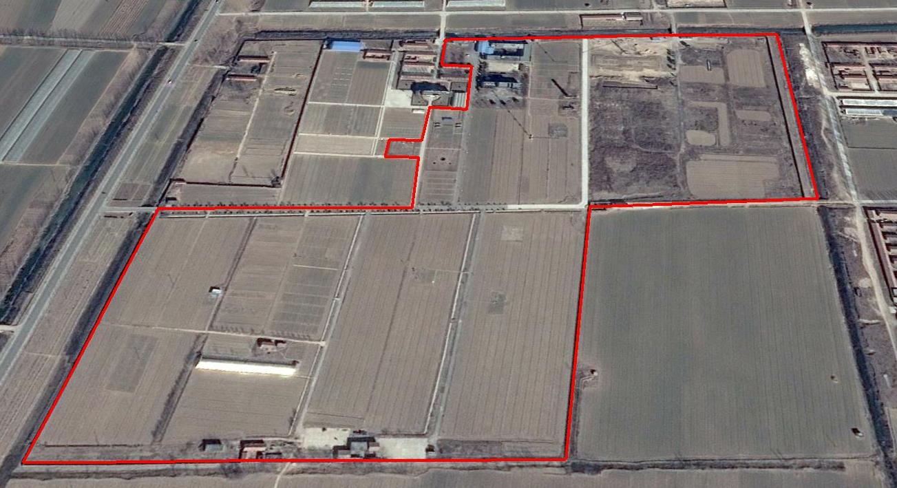
The Yucheng Comprehensive Experiment Station (YCES) of Chinese Academy of Sciences (CAS) is located at the irrigation district of the Yellow River Basin in the Huang-Huai-Hai Plain, also called North China Plain. Physiognomy is characterized as hinterland covered mainly by fluvo-aquic soil (Fluvisol or cambisal) and salinized fluvo-aquic soil in the Yellow River Alluvial Plain. This region is dominated by warm-temperate semi-humid monsoon climate with ample energy and water resources. Historically, natural disasters such as drought, waterlogging, salinization, and wind erosion frequently occurred, resulting in vulnerable ecological environment and low grain production. Integrated improvements and managements were deployed in last several decades, and this region has become suitable for planting winter wheat, corn, cotton, and soybean with high yields in the Huang-Huai-Hai Plain. Research objectives and contents Objectives: regional sustainable agriculture rational utilization of natural resources such as water, land, climate, biomass, etc. Contents: conducting long-term observations and experiments understanding the mechanism of energy transfer and mass cycle in farmlands developing models from point to regional scales improving and developing instruments and measurement methods improving agro-ecosystem managements demonstrating research results and technologies Research achievements: Outstanding research results and massive experiment data have been achieved at the YCES. The achievements cover research fields of farmland evapotranspiration, crop water use, water transfer mechanism, experimental remote sensing techniques, regional agriculture demonstration, and technology transfer. More than 1,000 papers, 15 monograph books, and 5 data sets have been published. A number of awards were granted by national, CAS, and international academic organizations, for example, Agriculture Prize granted by the Third World Academy of Sciences Science and Technology Progress Award by Chinese Academy of Sciences National Top Award of Science and Technology Progress
-
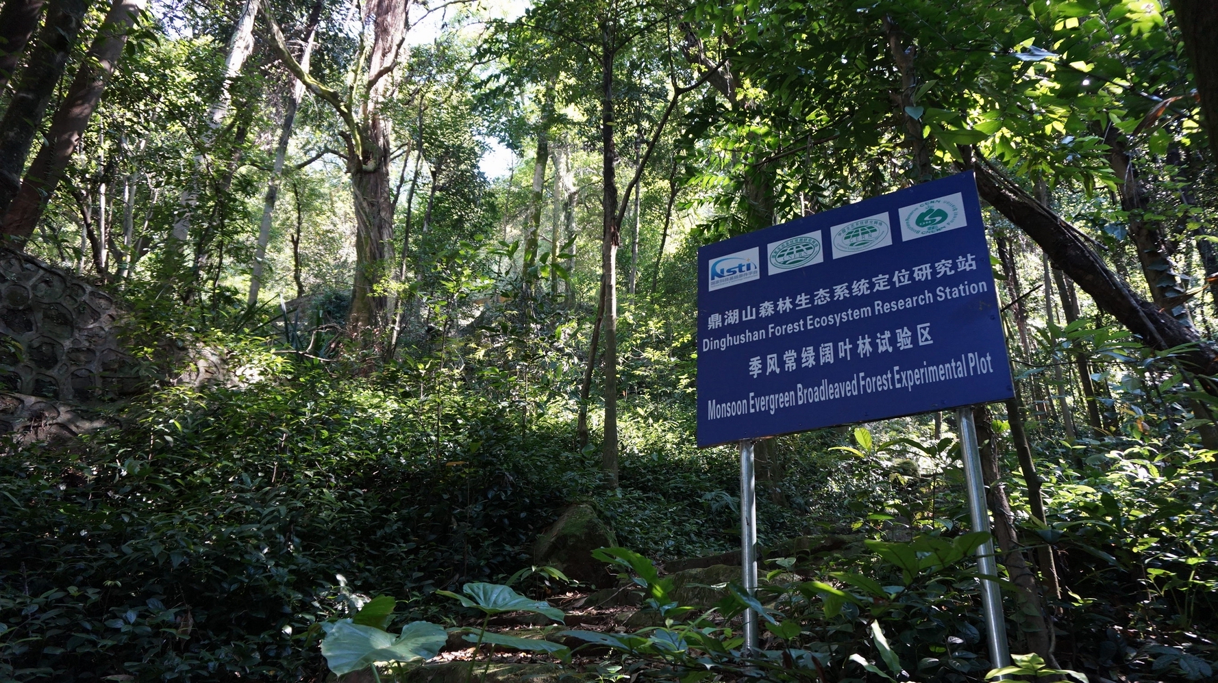
DHS has well protected monsoon evergreen broadleaf forest and its successional forests. Therefore, DHS is an ideal place to research successional processes and patterns of subtropical forest ecosystems, as well as to restore or rehabilitate the degraded forest ecosystems in subtropics of China.